Hampton University Archaeological Project: A Report on the Findings
Colonial Williamsburg Foundation Library Research Report Series - 0358
Colonial Williamsburg Foundation Library
Williamsburg, Virginia
1996
Colonial Williamsburg Archaeological Reports
Hampton University Archaeological Project:
A Report on the Findings
Hampton University
Archaeological Project:
A Report on the Findings
The Department of Archaeological Research
The Colonial Williamsburg Foundation
Williamsburg, Virginia
Submitted to:
William R. Harvey, President
Hampton University
July 1989
Re-issued June 2001
 Photo 1. Aerial view of sites.
Report Production
| Project Director: | Marley R. Brown III |
|---|---|
| Project Archaeologist: | Thomas F. Higgins III |
| Contributing Authors: | Andrew C. Edwards |
| William E. Pittman | |
| Gregory J. Brown | |
| Mary Ellen N. Hodges | |
| Marley R. Brown III | |
| Susan R. Alexandrowicz | |
| Eric E. Voigt | |
| Amy Kowalski | |
| Judy Ridner | |
| Consultants: | Cary Carson |
| Fraser Neiman | |
| Ivor Noël Hume | |
| Drafting: | Kimberly A. Wagner |
| Lucia Vinciguerra | |
| Photography/Layout: | Tamera A. Mams |
| Technical Editor: | Gregory J. Brown |
| Technical Assistance: | Shelly Liebler |
| (2001 Reprinting) | Ron Lippert |
This report replaces the first printing in 1989, which included all of the text and graphics following in Volume 1, and a roughly 1000-page artifact inventory in Volume 2. This inventory has not been reprinted, but is available on CD from the Department of Archaeological Research, Colonial Williamsburg Foundation.
| Page | |
| Report Production | i |
| List of Figures | v |
| List of Photographs | vii |
| List of Tables | ix |
| Preface | xi |
| Acknowledgments | xiii |
| Chapter 1. Research Design and Management Summary | 1 |
| Chapter 2. Environmental Considerations | 5 |
| Chapter 3. Project Methods | 7 |
| Chapter 4. Historical and Cultural Background | 11 |
| Chapter 5. The Prehistoric Sites (Mary Ellen N. Hodges) | 17 |
| A. Site 44HT36 | 17 |
| B. Site 44HT37 | 27 |
| C. Analysis of Prehistoric Finds | 35 |
| Chapter 6. The Historic Site--44HT55 | 45 |
| A. Description of the Major Features | 45 |
| B. The Structures at HT55 | 71 |
| C. Faunal Analysis (Gregory J. Brown) | 78 |
| D. Oyster Shell Analysis (Susan R. Alexandrowicz) | 95 |
| E. Paleobotanical Report (Eric E. Voigt) | 100 |
| Chapter 7. Artifact Analysis--44HT55 (William E. Pittman) | 113 |
| Chapter 8. Conclusions | 175 |
| A. The Prehistoric Sites | 175 |
| B. The Historic Site | 176 |
| References | 179 |
| Appendices | |
| 1. Muster of 1625 | 195 |
| 2. Catalogs of Tobacco Pipes | 199 |
| 3. Faunal Data | 235 |
| 4. Data Recovery Plan | 247 |
| Page | |
| 1. Context record | 8 |
| 2. Soil pH values | 10 |
| 3. Map of area showing conjectural early seventeenth-century property lines | 12 |
| 4. Overall drawing of 44HT36 | 19 |
| 5. Feature section drawings—44HT36 | 21 |
| 6. Soil chemistry—44HT36 | 28 |
| 7. Overall drawing of 44HT37 | 30 |
| 8. Feature section drawings—44HT37 | 33 |
| 9. Soil chemistry—44HT37 | 36 |
| 10. Prehistoric pottery—44HT36, 44HT37, and 44HT55 | 39 |
| 11. Detail of Structure A | 46 |
| 12. Posthole sections—Structure A | 47 |
| 13. Detail of Structure B | 49 |
| 14. Posthole sections—Structure B | 50 |
| 15. Detail of Structure C | 52 |
| 16. Posthole Sections—Structure C | 53 |
| 17. Detail of Structure D | 54 |
| 18. Posthole sections—Structure D | 54 |
| 19. Detail of Structure E | 56 |
| 20. Posthole sections—Structure E | 56 |
| 21. Detail Plan—Trash Pits A/B | 58 |
| 22. Section—Trash Pit A | 59 |
| 23. Section—Trash Pit B | 61 |
| 24. Section—Trash Pit C | 62 |
| 25. Section—Trash Pit D | 63 |
| 26. Section—Trash Pit E | 64 |
| 27. Section—ditch feature | 65 |
| 28. Overall drawing, 44HT55, showing location of slot fences | 66 |
| 29. Section drawings—slot fence trenches | 67 |
| 30. Section drawing of well | 70 |
| 31. Soil chemistry—44HT55 | 71 |
| 32. Detail plan of Structures A-E | 72 |
| 33. Detail of cellar wall—Structure A | 75 |
| 34. Detail of cellar steps—Structure A | 76 |
| 35. Detail of cellar floor—Structure A | 76 |
| 36. Kill-off patterns—pig, cow, and sheep/goat | 90 |
| 37. Oyster shell anatomy | 96 |
| 38. Oyster types and salinity regimes | 97 |
| 39. Oyster tongs | 99 |
| 40. Corn cob morphology | 104 |
| vi | |
| 41. Percentages of ware types represented | 119 |
| 42. Vessel form/function | 124 |
| 43. Window pane angles | 140 |
| 44. Drinking beaker foot fragment on projected vessel form | 142 |
| 45. Harrington histogram—entire site | 148 |
| 46. Harrington histogram—site by feature | 148 |
| 47. Harrington histograms—well, Trash Pit A, and Trash Pit B | 149 |
| 48. Harrington histograms—Trash Pit F, Trash Pit H, and Trash Pits F and H combined | 150 |
| 49. Imported marked pipes, probable origins | 151 |
| 50. Marked pipe concentrations | 151 |
| 51. Pipe bowl capacities—average cubic displacement | 153 |
| 52. Krauwinckel jetton | 168 |
| 53. Harrington farthing, Type 2 | 168 |
| 54. Bale seal | 168 |
| 55. Dutch pipe | 201 |
| 56. Imported clay tobacco pipes | 201 |
| 57. Imported clay tobacco pipes | 207 |
| 58. Imported clay tobacco pipes | 212 |
| 59. Decorated imported clay tobacco pipe stems | 224 |
| 60. Domestic clay tobacco pipes | 227 |
| 61. Domestic clay tobacco pipes | 231 |
| Page | |
| 1. Aerial view of sites | facing i |
| 2. Aerial view of 44HT36 | 18 |
| 3. Section/excavated plan of Feature 42 | 23 |
| 4. Aerial view of 44HT37 | 29 |
| 5. Detail of human bone in Feature 1001 | 31 |
| 6. Site 44HT36 during excavation | 37 |
| 7. Examples of Mockley ware | 40 |
| 8. Aerial view of 44HT55 | 45 |
| 9. Quarter-section—Trash Pit B | 60 |
| 10. Detail of cow skull in well | 68 |
| 11. Detail of brick cellar—Structure A | 77 |
| 12. Turtle plastron | 85 |
| 13. Cut deer antlers | 87 |
| 14. Reconstructed cow skull | 87 |
| 15. Red earthenware strainer, interior and side views with profile | 117 |
| 16. Unglazed earthenware flask, Mexican (?), with profile | 120 |
| 17. Thumb-impressed earthenware storage jar, with profile | 125 |
| 18. Red earthenware pipkin handle, with profile | 126 |
| 19. Unglazed pipkin lid, with profile | 126 |
| 20. Locally-made earthenware storage jar, with profile | 128 |
| 21. Iberian oil jar mouth, with profile | 129 |
| 22. French earthenware storage jar, exterior and interior views with profile | 129 |
| 23. North Italian slip marblized porringer handle, with profile | 130 |
| 24. European slipware fragments, with profiles | 131 |
| 25. North Devon slip-sgraffito dish, with profile | 131 |
| 26. Portuguese/Spanish majolica plate, interior and exterior views with profile | 132 |
| 27. Portuguese/Spanish plate, interior and exterior views with profile | 133 |
| 28. Portuguese/Spanish majolica plate fragment from the Jamestown Collection | 133 |
| 29. Portuguese majolica bowl, interior and exterior views with profile | 134 |
| 30. Portuguese majolica bowl rim fragment from the Jamestown Collection | 134 |
| 31. English delftware jug, with profile | 135 |
| 32. English delftware drug jar, with profile | 135 |
| 33. English delftware polychrome platter, interior and exterior views with profile | 136 |
| 34. Dutch delftware dish base, interior and exterior views with profile | 136 |
| 35. Bellarmine jug neck, with profile | 137 |
| 36. Westerwald blue and grey stoneware jug neck fragments, with profile | 138 |
| 37. String-trailed glass container fragment, with profile on projected vessel form | 141 |
| 38. Stemmed wine glass base, with profile | 143 |
| 39. Glass linen smoother handle, with profile on projected form | 143 |
| viii | |
| 40. Spoon bowl with maker's mark | 164 |
| 41. Bone "needle" | 164 |
| 42. Bone comb | 166 |
| 43. "Lace" | 166 |
| 44. Lathe-marked plaster | 169 |
| 45. Roofing tile fragments | 169 |
| 46. Overall, structural postholes and cellar of Structure A, ground view | 177 |
| 47. Imported clay tobacco pipes | 216 |
| 48. Imported clay tobacco pipes | 220 |
| Page | |
| 1. Feature Summary—44HT36 | 25 |
| 2. Feature Summary—44HT37 | 32 |
| 3. Prehistoric Ceramic Sherds | 37 |
| 4. Vessel Profiles and Rim Diameters, Mockley Ware | 39 |
| 5. Earthfast Virginia Buildings | 75 |
| 6. Allometric Values | 81 |
| 7. Taxa Identified in the Hampton University Assemblage | 83 |
| 8. Relative Dietary Importance | 88 |
| 9. Estimated Meat Frequencies by Period | 89 |
| 10. Habitat Preferences of Identified Fish | 92 |
| 11. Habitat Preferences of Identified Reptiles/Amphibians | 92 |
| 12. Habitat Preferences of Identified Birds | 93 |
| 13. Habitat Preferences of Identified Mammals | 93 |
| 14. Oyster Shell Attributes by Percentage | 100 |
| 15. Oyster Shell Attributes by Raw Count | 101 |
| 16. Oyster Shell Attributes—Summary | 102 |
| 17. Oyster Shell Size | 102 |
| 18. Botanical Remains in 44HT36 Samples | 107 |
| 19. Botanical Remains in 44HT37 Samples | 108 |
| 20. Botanical Remains in 44HT55 Samples | 109 |
| 21. Ceramic Ware Type Quantification | 118 |
| 22. Ceramic Vessel Form Quantification | 121 |
| 23. Ceramic Vessel Function Quantification | 123 |
| 24. Tobacco Pipe Decorations from 44HT55 | 144 |
| 25. Binford Pipe Stem Dating Calculations | 146 |
| 26. Maker's Marks on Imported Tobacco Pipes | 153 |
| 27. Artifact Function Categories | 156 |
| 28. Summary of Food Preparation and Consumption Items | 170 |
| 29. Summary of Cutlery Items | 170 |
| 30. Summary of Tools and Equipment | 171 |
| 31. Summary of Weaponry and Armor | 171 |
| 32. Summary of Personal Items | 171 |
| 33. Summary of Textile-Related Items | 172 |
| 34. Clothing Pin Distribution | 173 |
| 35. Summary of Trade-Related Artifacts | 173 |
| 36. Summary of Furniture-Related Artifacts | 174 |
| 37. Summary of Architectural Artifacts | 174 |
| 38. NISP, MNI, and Pounds of Usable Meat | 237 |
| 39. Biomass | 240 |
| 40. Age Distribution for Domestic Pig | 243 |
| x | |
| 41. Age Distribution for Domestic Cow | 244 |
| 42. Age Distribution for Domestic Sheep/Goat | 245 |
Preface
In 1979, a plowed field on the Hampton University campus containing site 44HT55 was surveyed by Howard MacCord for the Virginia Department of Highways and Transportation (now the Virginia Department of Transportation). This survey was conducted as part of the examination of the right-of-way for a proposed new extension of state Route 143. MacCord did no excavation, but identified a seventeenth-century domestic site, 44HT55, on the basis of a surface sample of imported and locally-made clay smoking pipes and a few fragments of tin-enamelled earthenware and Rhenish stoneware. Based on this material, MacCord attributed the site to the third quarter of the seventeenth century.
The parcel was again examined in 1980 by Mark Wittkofski, staff archaeologist with the Virginia Division of Historic Landmarks. Wittkofski did some limited subsurface testing in the area of 44HT55, finding two features: a narrow trench identified as support for a paling fence, and another wider trench. Wittkofski concluded that:
A phase three excavation will be required for 44HT55 if it becomes threatened by any construction. Limited testing indicated the site had good preservation of subsurface cultural features. Since much of Hampton has been heavily urbanized, this site could provide important information concerning the changes which took place in the lower Tidewater region (1980:6).
Subsequent construction of the Route 143 extension and interchange did not affect 44HT55, and the site was left undisturbed until the spring of 1987. Knowing of the site's existence, Hampton University officials arranged with the local chapter of the Archaeological Society of Virginia to examine site 44HT55 further and salvage any significant remains prior to the development of a housing complex and shopping center by the university.
The Kicotan Chapter of the A.S.V. began their investigation of the site by digging a number of test trenches in the plowed field. Almost immediately, they encountered a brick-lined cellar. Other trenching activities in the vicinity revealed several features, which, along with the cellar, were partially excavated by the Kicotan Chapter.After these discoveries were made known, university officials sought professional advice. Museum Director Jeanne Zeidler contacted the Tidewater Cultural Resource Center at the College of William and Mary, and the discoveries made by the A.S.V. were reviewed in the field by T.C.R.C. officials. Discussion with Hampton University representatives indicated the possibility of funding through a United States Department of Housing and Urban Development (HUD) grant to help finance the project. In view of the recommendations made in Wittkofski's 1980 report, the Center suggested a proper Phase II investigation of HT55 be undertaken concurrently with a combined Phase I and II study of the entire development parcel. The T.C.R.C. completed this work in mid-September 1987, as part of a cooperative agreement with the University (see Appendix 4).
Upon completion of the Phase I and II investigations, the university asked the Colonial Williamsburg Foundation's Department of Archaeological Research to carry out Phase III excavations on the three sites (44HT36, 44HT37, and 44HT55) identified by the T.C.R.C. Field work headed by Thomas F. Higgins III began on October 27, 1987 and was completed in early May 1988. This is a report of those findings.
xiiAcknowledgments
The Hampton University Archaeological Project was successfully completed through the efforts of a great number of interested and dedicated people. The authors would like to thank the following for their contributions:
Hampton University
William Harvey, University President, for his interest and encouragement.
Charles Wooding, University Development Director, for his efforts in coordinating research interests with construction efforts, as well as for his patience and understanding.
Jeanne Zeidler, University Museum Director, who deserves special thanks for her part as liaison between the University and the Foundation, securing space and equipment for the effort, and offering support and encouragement to the archaeological team.
Additionally, the Maintenance and Landscape departments at Hampton University are especially thanked for helping numerous times by providing equipment and supplying needed electricity to the site. The R.O.T.C. Department allowed the field crew to use their facilities and was, thankfully, not too upset about the holes in their parade ground.
We are also grateful to the Audio-Visual Department for loaning us a brand new IBM Model 30 computer for database management.
Department of Historic Landmarks
Tony Opperman and Randy Turner, for their aid and suggestions regarding the interpretation and excavation of the aboriginal sites.
Bruce Larson, for his help in guiding the Foundation and the University through the compliance requisites.
Colonial Williamsburg
The field and laboratory crew who expertly excavated all three sites in spite of a long and cold winter and the sixty-mile round-trip commute:
Thomas Higgins, Project Archaeologist
Lucie Vinciguerra, Field Technician
Charles Thomas, Field Technician
Nathaniel Smith, Field Technician
Meredith Moodey, Field Technician
William Sheppard, Excavator
Gunnar Brockett, Excavator
James Card, Excavator
Amy Kowalski, Laboratory Technician
Judy Ridner, Laboratory Technician
Julie Bledsoe, Laboratory Technician
Walter Schmidt, Laboratory Volunteer
Kathleen Pepper, Laboratory Technician, who supervised the Hampton laboratory activities and offered her help and guidance.
Joanne Bowen Gaynor, who provided general supervision and advice in the faunal analysis.
Nan Reisweber, Department of Archaeological Research secretary, who provided administrative support.
Robert C. Birney, Sr. Vice-President, who approved the project and offered his support.
Cary Carson, Vice-President, Research, who offered administrative support as well as his expertise in seventeenth-century vernacular architecture.
Ivor Noël Hume, Foundation Archaeologist (Retired), who also visited the site, offering his expert advice on both the interpretation of the features and identification of many of the artifacts recovered.
xivRob Hunter, Dave Muraca, and Patricia Samford, who offered their help in the field, pitching in when needed the most.
Dave Doody of the Colonial Williamsburg Audio-visual Department arranged for the helicopter and expertly photographed the sites from the sky.
Tom Olds, who often volunteered his much appreciated efforts, both in the field and laboratory.
Susan Wiard, who contributed her precise and invaluable editorial skills for the artifact analysis section.
Others
Fraser Neiman of Yale University, who provided his expert advice on vernacular architecture.
Professors Norman F. Barka of the College of William and Mary and Jay Custer of the University of Delaware, who likewise gave us the benefit of their expert opinions.
We would also like to acknowledge the invaluable assistance of the staff of the Virginia Department of Historic Landmarks in Richmond, the National Park Service facility at Jamestown, and the Departments of Birds and Herpetology of the Smithsonian Institution's National Museum of Natural History for access to their collections for comparative study.
Chapter 1.
Research Design and Management Summary
Site Significance
The development of the area on the Hampton University campus in which the historic and prehistoric sites were located was accomplished, in part, with financial assistance from the United States Department of Housing and Urban Development (HUD). As a result, federal mandates require that the significance of these sites be assessed in terms of the criteria for eligibility to the National Register of Historic Places. For nomination, a site must be:
- A. Associated with significant events in the broad patterns of national history,
- B. Associated with the lives of persons significant in our past,
- C.Representative of a time period, or method of construction, or the work of a master, or
- D.Capable of yielding important information about the past (from Brown and Bragdon 1986:2).
Clearly, all three of the sites take on respective importance primarily in the character and quality of the information they contain. As with most archaeological sites, this information is most directly related to the first and fourth of the National Register criteria. Evaluating the research potential of these sites more specifically is a matter of identifying the relevant historical and cultural patterns and processes to which they relate, and specifying the categories of archaeological data recovered which will help to understand these events and developments. Much of the intellectual and procedural framework for this evaluation is based on a comprehensive historic preservation plan for the James-York peninsula, Toward a Resource Protection Process: Management Plans for James City County, York County, City of Poquoson, and City of Williamsburg, prepared by the Colonial Williamsburg Department of Archaeological Research in 1985 and 1986 (Brown and Bragdon 1986).
The Prehistoric Sites — 44HT36 and 44HT37
Study Unit III in Colonial Williamsburg's 1986 resource protection plan for the Peninsula addresses several research questions pertinent to the investigation of sites 44HT36 and 44HT37. On the basis of radiocarbon analysis and associated diagnostic artifacts, the prehistoric sites at Hampton University can be dated to the latter part of the Middle Woodland Period (500 B.C.- A.D.1000). This traditional chronological unit falls within a broader era of cultural adaptation, spanning the period 2000 B.C. to A.D. 1000, defined in Study Unit III.
Referred to by some as the Woodland I Period (Custer 1984, 1989), this era is distinguished by the emergence of a more sedentary lifeway among the Native American populations of the Peninsula and the larger Middle Atlantic Region, although the exact processes involved with this change remain unclear. Earlier, populations within the region were characterized by forest-based economies, high residential mobility reflecting seasonal resource availability, small group size, and a portable tool assemblage. Beginning ca. 2000 B.C., however, the archaeological record displays evidence for the development of intensive riverine and estaurine adaptations and increased residential permanency by larger group aggregates. Technological innovations through the period included the development a ceramic container technology, the construction of food storage facilities, and the development of plant horticulture. The latter is believed to have initially involved the 2 intensive use of wild, herbaceous annuals, with true domesticates integrated at a later date.
Using guidelines from the management plan, sites 44HT36 and 44HT37 were excavated with the intent of adding to existing knowledge of the social, economic, and demographic organization, subsistence activities, and material culture of Native American peoples during this era. Prior to identification of these specific sites, the Hampton University project area had been judged likely to contain prehistoric archaeological remains due to its topographic setting and proximity to estuarine resources. A previous archaeological survey (Wittkofski 1980) had recovered small surface collections of aboriginal pottery and stone tools in the nearby fields. The first clear indication of the potential prehistoric significance of the area came, however, during Phase I and II testing by the Tidewater Cultural Resource Center in the summer of 1987, when it was discovered that pit features were preserved below the plowzone at sites 44HT36 and 44HT37. The presence of pit features suggested these sites represented residential bases involving the storage of plant foods. A preliminary date for the sites was provided by the recovery of Mockley ware, a shell tempered, cord marked and knotted net impressed ceramic common on late Woodland I Period sites within the Coastal Plain of Virginia, Maryland, and Delaware.
In order to address the specific research questions posed in the management plan, data recovery strategy at 44HT36 and 44HT37 included the excavation of the majority of the pit features exposed at the sites and analysis of their depth, breadth, and contents in order to determine their probable function. Material suitable for radiocarbon analysis was collected to date the occupations and to provide additional information on the occurrence of Mockley ware. Soil samples were collected, treated, and analyzed by a paleoethnobotanist to determine which wild or domesticated plants were used by the inhabitants. Rather than limiting the investigation to the small, non-contiguous test units initiated during the Phase I/II investigation, expansive excavation areas were exposed at each site with the hope of obtaining information on the overall plan and internal structure of the settlements—whether shelters, cooking, and other activity areas existed, and, if so, how they were arranged.
Excavation and analysis of the sites suggested that they represent small, residential bases. Unfortunately, only limited information was generated on the plan of the settlements. Within the excavation area exposed at 44HT37, some clustering of pit features was evident, but no evidence for structures was found at either site. Either none existed, or any evidence had been destroyed by subsequent plowing or landscaping. The extremely small size of the artifact assemblages, which were comprised almost exclusively of ceramic sherds, precluded sound spatial analysis. The excavation, on the other hand, did produce some potentially significant data relevant to an understanding of ceramic and horticultural development during the Middle Woodland Period. Radiocarbon analysis of charcoal associated with ceramics and plant remains from the sites yielded some of the earliest dates yet obtained within the Middle Atlantic Region for shell tempered ceramics (first century A.D.) and for the possible limited cultivation of maize (fourth century A.D.).
The Seventeenth Century
Site—44HT55
Study Unit X in Colonial Williamsburg's resource protection plan, "Establishment of Colonial Society: Development of Tidewater Society and Economy A.D. 1630 - A.D. 1689" outlines "the development of a distinctive Anglo-Virginian lifestyle in response to the conditions of the Chesapeake" (Brown and Derry 1986). During this period, the plantation system emerged, based on the cultivation of tobacco and a reliance upon bound and slave labor. The so-called "operating plan" for this study unit identifies a broad range of property types that should be recoverable as archaeological sites. These include plantations of both large and small planters, tenant farms, public buildings, taverns and other commercial sites. 3 Until recently, however, there has been a bias toward the recording and excavation of domestic sites associated with the planter elite, such as those at Kingsmill and Governor's Land, both in James City County (Brown and Derry 1986).
The Hampton University site is of special importance primarily because, although it was probably occupied by a fairly wealthy or socially-prominent household, it was never, at least in the seventeenth century, part of any large private land holding. It was, in fact, probably tenant land that was not part of any permanent estate until it was patented in 1642. Even then it was not a familial holding, but part of a 116-acre tract which likely included several other similar domestic complexes. Site HT55, in fact, probably because of its association with the large tract patented by the Virginia Company, was part of a rural enclave in what was becoming a relatively urban area (although little of Hampton itself, then only part of Elizabeth City County, ever actually became heavily urbanized). It remained such until acquisition by Hampton University in 1938. Thus the full-scale excavation of the site has afforded archaeologists the opportunity to add significantly to the understanding of the material culture of the English population in second quarter seventeenth-century Virginia.
What, then, are the archaeologically-discernible things which distinguished the landless tenant farmers in the second quarter of the seventeenth century from the landed gentry? Is it their houses and their possessions, or is it something less tangible, such as their political connections, education, or ambition? The architectural ghosts and the rubbish left to posterity at sites from this period do not seem to point to any one factor which would explain or define these historically-known differences. Almost all of the houses built in Tidewater from 1625 to 1650 were relatively small, earthfast structures composed of wood, whether home of lord or laborer. Additionally, some of the same ceramic types found at Jamestown, the core of the elite, and at Causey's Care, on the periphery, were also found at HT55. The artifacts recovered from HT55 seem, in fact, to indicate that the residents of the site had sufficient wherewithal to purchase both ceramics and glassware of a quality suggestive of a high standard of living.
The question of social and economic status of the folks living at 44HT55 can be addressed through a variety of sources, but there are few definitive answers. Since there appears to be no evidence that the property served as a glebe-house for the nearby church, an automatic status indicator, that of the clergy, cannot be assumed, nor can it be used, unfortunately, to seek clues regarding the economic well-being of ministers during Virginia's early period.
Looking for insights into the status of the site's inhabitants through their architecture is also questionable ground on which to tread. As pointed out in Chapter 6, social dichotomies between masters and indentured servants were not as well-defined in the first half of the seventeenth century as they were in the second half. This is reflected in the architecture of the houses as well as in the historical record (Neiman 1980), and even in the general layout of the domestic complex. Servants often lived in virtually the same rooms as their "masters." In the Muster of 1625 (Appendix 1), Robart Thrasher and Roland Williames apparently lived in one house with their servant, John Sacker. John and Elizabeth Haney and Nicolas and Mary Rowe also lived with their servants Thomas Moreland and Ralph Hood, as there is only one house listed in these musters. Neiman (1980) found a reference which, off-handedly, mentions a "Negro" servant sitting and drinking with his mistress, a situation unlikely to arise only fifty years later.
It has been demonstrated by Neiman and Carson that houses built by the elite, or at least the "upper echelon" of society, appear to have been constructed in much the same manner as those belonging to people on the lower end of the economic ladder. Even planters who could probably well afford brick houses, or at least frame houses with brick chimneys, had houses constructed entirely of wood with chimneys of mud. There are notable early seventeenth-century 4 exceptions, of course, such as Piercey's house at Flowerdew Hundred (Barka 1976), which had a brick and stone foundation along with the wooden posts and a large double brick chimney. But this was an exception; the earthfast structures at Kingsmill, Epps Island, Pettus, and Drummond plantations were the norm.
Site HT55 consisted of five seemingly meager structures. Atypical of most post-in-ground dwellings, Structure A contained a tile-floored, brick-lined cellar—not a feature as easily or as cheaply constructed as the more common wood-lined ones. It also sported two sets of brick steps leading into the cellar, although the chimney(s) were constructed of wood and mud. Evidently, safe storage of food, a consumable, was more important to the owner than a more elaborate and attractive house. The house met the needs of the inhabitants for about 30 to 40 years, although extensive repairs were apparently necessary.
Chapter 2.
Environmental Considerations
The Climate
Weather on "the Peninsula," as the area between the York and James Rivers is locally known, is characterized by relatively mild winters and warm summers, but not without extremes on both ends of the thermometer. John Smith accurately described the area's climate in 1624:
The Sommer is hot as in Spaine; the Winter cold as in France or England. The heat of sommer is in June, July, and August, but commonly the coole breeses asswage the vehemency of the heat. The chiefe of winter is halfe December, January, February, and halfe March. The colde is extreame sharpe, but here the Proverb is true, that no extreame long continueth.
The winds here are variable, but like the thunder and lightning to purifie the ayre, I have seldome either seen or heard in Europe. From the Southwest came the greatest gusts with thunder and heat. The Northwest winde is commonly coole and bringeth faire weather with it. From the North is the greatest cold, and from the East and Southeast as from the Barmudas, fogs and raines
(Smith 1624:21).
Captain Smith also describes the quick changes sometimes exhibited in Tidewater weather, a fact to which anyone who has lived in the area for much time can attest. Statistically, however, the peninsula's weather is rather mild, the average July temperature being 77.7°F, and the average in January 40.3°F. Annually, the average is 59.1°F. Summer temperatures can, on occasion reach above 100°, and winter nights plummet to near 0°, but both extremes, especially the latter, are rare. Annual rainfall averages about 42 inches, approximately 8.6 inches of which may be recorded as snow (Virginia Peninsula Industrial Council [V.P.I.C.] 1976).
Resources
Total land area of the peninsula is about 262,400 acres, roughly half of which is forested (much less, of course, in the Hampton area). Forests are primarily composed of pine, oak, and hickory trees. The local ground water is generally acidic and contains high amounts of iron, making it unfit for most purposes. At depths below 200 feet, a high salt content pervades all well water in the Hampton area. All of the surface water around Hampton is quite salty, supporting a great deal of marine life including fish, oysters, clams, and crabs (V.P.I.C. 1976).
Geology
Hampton and the peninsula are located on the very eastern edge of Virginia's Coastal Plain, a geologically-old area primarily composed of "loose, unconsolidated beds of sand, gravel, clay, and marl"(Virginia Governor's Office 1968:30) , below which is Cretaceous and Tertiary sedimentary rock (Andrews 1981). As Hampton is located at the very tip of the peninsula, it is at the lowest elevations (site HT55, for instance, is about 10 feet A.S.L.). On the upper part of the peninsula, near Williamsburg, elevations may be as high as 120 feet A.S.L.
The Hampton University sites are at the mouth of the James River as it empties into the Chesapeake Bay. The Bay, probably the greatest influence on the early adventurers, is still today an extremely important waterway. Affording protection from the sea, as well as a great abundance of marine life, the Chesapeake Bay has an area of 4,300 square miles, a shore line of 4,500 miles, is about 165 miles long, but has an average depth of only 20 feet (Power 1970). The early importance of Hampton is directly related to its strategic location in the part of the Bay across from 6 Norfolk—the entire area composing a commercially-important region known as Hampton Roads.
Chapter 3.
Project Methods
A. Excavation
The Native American Sites
The methods and techniques used to carry out Phase III excavations on the three Hampton University sites were structured to obtain the types of data pertinent to addressing several research questions discussed in Chapter 1. The two Native American sites—44HT36 and 44HT37—provided a unique opportunity to broaden the current knowledge of the material and culture history of aboriginal populations in the Tidewater region during the latter part of the Middle Woodland Period.
Phase I and II test excavations performed by the Tidewater Cultural Resource Center at the College of William and Mary revealed subsurface features with few or no cultural remains in the topsoil overburden. When Colonial Williamsburg began the Phase III study, this overburden was therefore stripped by machine until features were evident. A grid was established over the sites, and the features were subsequently mapped and given appropriate numerical designations. All features were sectioned, either in halves or in quarters, depending upon size. A known percentage of the fill from each feature in excess of 2000 ml was retained for wet-screen, flotation sampling, and chemical analysis. The remainder of the fill was screened through one-quarter inch or one-eighth inch mesh hardware cloth. The carbon samples collected were sent to Beta Analytic Laboratories for radiocarbon dating. Artifacts recovered from the sites were generally transferred to the on-campus laboratory for processing at the end of each work day, but items requiring special treatment could be taken to the lab within minutes of their discovery.
The recording method used on the aboriginal sites was the same as that used on other Colonial Williamsburg sites. Features were given consecutive numerical designations as they were mapped. Layers within the features were given context numbers as they were excavated, and all pertinent information relating to the feature or context was recorded on forms designed for computer entry (see Figure 1). This information was later transferred to computer using dBase III-compatible database management software. Major features were photographed in plan and section.
The Historic Site
Excavation and recording techniques employed at HT55 were essentially identical to those used at the Native American sites. Previous archaeological investigations, years of surface collection, and other considerations prompted the stripping of topsoil and plowzone from the site, exposing the subsurface features. The area was gridded into the customary ten-foot squares in order to facilitate mapping of the large site. Again, features were given sequential numbers as they were mapped. Each unit was mapped on a 1:24 scale, producing a composite site plan. All features were sectioned and a portion of the fill retained for chemical, flotation, and wet screen sampling. Most features were photographed in plan and section.
B. Soil Analysis
Flotation
(Charles Thomas and Lucie Vinciguerra)
Soil samples recovered from the Hampton University sites were transported to the Department of Archaeological Research facilities in Williamsburg for flotation. The flotation device used in processing soil samples consisted of two
main sections. The base was a 15-gallon cylindrical NALGENE tank with two holes drilled
8
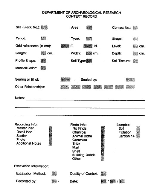 Figure 1. Context record.
9
through the wall near the base. One hole was fitted with a plug to serve as a drain for emptying the tank between samples, and the other with an L-shaped length of copper pipe running upward through the bottom of the tank. An adjustable spray nozzle was attached to this pipe.
Figure 1. Context record.
9
through the wall near the base. One hole was fitted with a plug to serve as a drain for emptying the tank between samples, and the other with an L-shaped length of copper pipe running upward through the bottom of the tank. An adjustable spray nozzle was attached to this pipe.
The upper portion of the device was constructed of a 20-quart utility tub, with a shallow, rectangular hole cut near the upper edge, and a broad, flat spout attached. The bottom of the tub was removed and replaced with a 24-by-24 brass mesh cloth (wide diameter: 0.014"), which retained all particles greater than 0.0277" (0.70 mm). The tub was selected to create a snug, water- tight fit when pressed down into the NALGENE tank.
Aluminum baking pans with bottoms removed and replaced with 40-mesh brass wire strainer cloth were used for collection of the floated material. These would collect particles of at least 0.0175" in diameter.
Water was run into the base tank from the bottom until it filled the NALGENE tank and spilled over the spout. Then, at high pressure, a stream of water was directed through the screen to create turbulence. The soil was sprinkled into the sample bucket, the lighter fraction of which was carried away through the spout and into the collecting tray. The sample could be agitated slightly by hand to break up any highly coherent soil, if necessary. The process continued until there was no further suspended material visible in the flow to the collecting tray. The tray was then set aside for air drying while the heavy fraction was retained in the screen fitted in the NALGENE tank. The water was drained and the sample extracted between each process.
This method of collecting flotation samples minimizes the handling of delicate material, which is especially fragile when wet. The standard poppy seed test, i.e., placing 100 poppy seeds in a sample before it is processed and counting them after flotation, produced an average recovery rate of 95.5%. This test was run periodically in order to monitor the conditions of the screens, adhesives, and fittings.
Chemical Analysis
Soil samples taken from the three sites were analyzed by the Virginia Department of Agriculture facility at Blacksburg for the following elements: potassium (K), phosphorus (P), calcium (Ca), and magnesium (Mg). Soil pH and the amount of humus were also measured.
Although the constituent element analysis was very revealing, the latter two tests revealed little of major archaeological interest. All of the samples taken were slightly acidic (Figure 2), both the control samples and those taken from specific features. However, the pH value of the soils is significantly affected by rainwater and modern farming practices, and it is likely that these are the principal factors being measured. The pH value of the soil simply gives an archaeologist an idea of how well some items, such as bone, shell, and metals, will be preserved in the ground. The slightly acidic conditions suggest that all of these materials were adversely affected, but probably not drastically so.
The presence of high levels of potassium in the soils of features is generally an indicator of the presence of wood ash. Phosphorus, on the other hand, seems to indicate the presence of human waste material and is usually extremely high in historic- era privies. High calcium levels are generally indicative of the presence of decaying shell or bone within a feature or layer (Pogue 1989). Large amounts of calcium will remain in the soil after the source has seemingly disappeared. Although the samplers were routinely tested for magnesium, which may be important for the health of some crops, its archaeological significance is yet unknown.
C. Artifact Analysis
Artifacts recovered from the field were brought to the archaeological laboratory established on the Hampton University campus. As quickly as possible, the artifacts were washed according to D.A.R. laboratory standards, dried, sorted into categories, and labeled with site and provenance
10
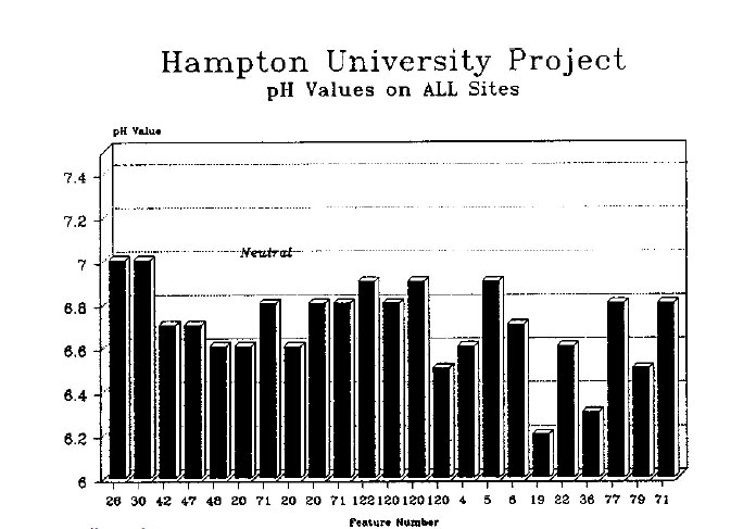 Figure 2. Soil pH values.
number. Oyster shell and brick fragments were separated, counted, and placed in temporary storage. The oyster shells were later sent to Williamsburg for analysis.1The remainder of artifacts were coded according to type and entered into a custom dBase III-compatible program on an IBM Model 30 microcomputer provided by the University. The processed artifacts were placed in open-rack storage in the laboratory until the analysis was complete. All faunal material was remanded to the Zooarchaeological Laboratory
for analysis, and any artifact in immediate need of conservation was transported to the main lab facility in Williamsburg for treatment.
Figure 2. Soil pH values.
number. Oyster shell and brick fragments were separated, counted, and placed in temporary storage. The oyster shells were later sent to Williamsburg for analysis.1The remainder of artifacts were coded according to type and entered into a custom dBase III-compatible program on an IBM Model 30 microcomputer provided by the University. The processed artifacts were placed in open-rack storage in the laboratory until the analysis was complete. All faunal material was remanded to the Zooarchaeological Laboratory
for analysis, and any artifact in immediate need of conservation was transported to the main lab facility in Williamsburg for treatment.
Ceramics and smoking pipes were crossmended under the supervision of the Collections Supervisor. The smoking pipes and some ceramic vessels were also removed to Williamsburg for analysis. The aboriginal artifacts from all three sites were also transported to the main laboratory for analysis by a prehistoric specialist.
All materials from the sites were returned to the custody of the University Museum at the completion of all reporting activities. Chapter 7 of this report is a full discussion of the artifacts from the historic site. Artifacts from the prehistoric sites are discussed in Chapter 5.
D. Paleobotanical Analysis
This study was assigned to consultant Eric Voigt. His report is included in Chapter 6-E.
E. Faunal Analysis
The zooarchaeological study of site HT55 was conducted by staff archaeologist Gregory J. Brown. His methods are described below; his report is included in Chapter 6-C, with tables and detailed data in Appendix 3. Faunal remains from HT36 and HT37, which were both sparse and badly fragmented, were not analyzed.
Chapter 4.
Historical and Cultural Background
The scope of the historical background of the Hampton, Virginia area will be primarily limited to a discussion of events taking place (and to people living or doing business) on the east side of the Hampton River during the seventeenth century. The domestic complex at HT55, which is the primary focus of this report, was established, inhabited, and abandoned between the third and seventh decades of that century, and little archaeological evidence exists at this site which would add significantly to the interpretation of later periods in Hampton's long history.
The known culture history of the Native American peoples who have lived in the Hampton Roads area, especially during the first half of the first millennium, is necessarily limited by the somewhat meager amount of archaeology done in the immediate vicinity over the past several decades. The sites at Hampton University are, perhaps, best understood within a regional context which would include the Virginia Coastal Plain and the larger Middle Atlantic area.
A more comprehensive, non-site-specific history of the Hampton area can be found through the following sources:
- 1983
- Phase II Archaeological Survey of a Proposed Dredging Site in the Hampton River, Hampton, Virginia. Report prepared by Underwater Archaeological Joint Ventures for Langley and MacDonald, Inc.
- 1907
- Narratives of Early Virginia, 1606-1625. Charles Scribner's Sons, New York.
- n.d.
- Elizabeth City County, Virginia, 1782-1810. M.A. thesis, College of William and Mary, Williamsburg.
- 1936
- The First Plantation, A History of Hampton and Elizabeth City County, 1607-1887. Hampton.
A. Seventeenth-Century Hampton
Several weeks before Capt. Christopher Newport, Capt. John Smith, George Percy, and their party formally established the English foothold in North America at Jamestown, they were enjoying the hospitality of their new-found (but short-lived) neighbors at Kicotan, an Indian town having "eighteen houses pleasantly seated upon three acres of ground" (Smith 1608). It is believed that Kicotan probably stood in the area presently occupied by the Veterans Administration Hospital. Recognizing the strategic importance of the Kicotan area, especially Point Comfort, from which the mouth of the James River could be guarded against the Spanish threat to the south, a fort (called Fort Algernon) was built there in 1609. Two additional forts, Henry and Charles, were erected at the mouth of the Hampton River on its east and west banks, respectively. Fort Henry probably stood between John's Creek and Strawberry Banks, on the shore of Hampton Roads. The military buildup was effective in more ways than one, as the Indians were driven from Kicotan under orders from Sir Thomas Gates in 1610 (McCartney 1983).
Both Thomas Dale and William Strachey wrote that two to three thousand acres of land had already been cleared by the Indians at Kicotan. Although they were not specific, this land
12
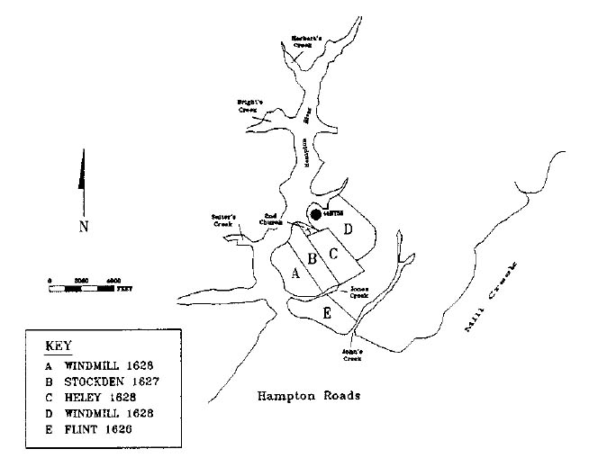 Figure 3. Map of area showing conjectural early seventeenth-century property lines.
was probably located on both sides of the Hampton River. The land on the east side of the river (again about 3000 acres) was designated Company land and used to provide a place for those persons coming to the colony at the Virginia Company's expense. It was also used to house the military contingent protecting the area from enemy attack, be it derived by land or sea (McCartney 1983).
Figure 3. Map of area showing conjectural early seventeenth-century property lines.
was probably located on both sides of the Hampton River. The land on the east side of the river (again about 3000 acres) was designated Company land and used to provide a place for those persons coming to the colony at the Virginia Company's expense. It was also used to house the military contingent protecting the area from enemy attack, be it derived by land or sea (McCartney 1983).
In 1619, at the first meeting of the House of Burgesses, the name of Kicotan was changed to the Corporation of Elizabeth City. At that time, and until 1637, Elizabeth City also included the area now known as Norfolk and Virginia Beach. Elizabeth City was then the most populous of the four corporations. Virginia Company records indicate that 349 persons were living there in early 1624. Over a hundred had died during the difficult years following the Massacre of 1622, even though Elizabeth City had fared well in comparison with other areas.
The Muster of 1625 begins to shed the first light on the specific history of site HT55. It, fortunately, separates those persons living on the west side of the river from those living on the east (see Appendix 1). Unfortunately, it does not indicate the exact location of the homesteads or show how much land was involved in each. It does name names, however; names that can, in some cases, be traced though the patent records to other tracts of land on both sides of the river.
The first surviving mention of a lease or patent on the east side of the Hampton River near HT55 is in a lease of 50 acres to Lt. Thomas Flint on 23 February 1626 (page 77 of the original patent book). It leases the land and houses in the Indian Thicket, an area between two creeks (John's and Jones) which had been occupied by Capt. Whitacre. This was former Company land adjacent to Fort Henry Fields, the present site of the Veterans Administration Hospital. This land is 13 included in Capt. Francis West's muster of 1625. Two patents and two pages later in Patent Book I, 50 acres is leased to Rev. Jonas Stockden, who, in the 1625 muster, is listed as living on the west side of the river. The boundaries of his lease are quite specific: 50 acres on the eastern side of the Southampton River, within the Company's Land at Elizabeth City, abutting on its south side a Creek parting this from the land in occupation of Lt. Flint, commonly called the "Indian Howse Thickett," north on another Creek, west on said river and east on the Maine woods. This was recorded on September 8, 1627 (Nugent 1979).
The next lease listed involving the area near 44HT55 is in Patent Book I, page 90, to Christopher Windmill, Planter, for 60 acres abutting south on the plantation called "Indian Howse Thickett," formerly granted to Lt. Flint. The tract was bounded on the north by the "ground of Jonas Stockden, Minister, dec'd.," and on the west by the Southampton River. The lease is dated 20 September 1628. This appears, at first glance, to be in virtually the same spot as Stockden's 50 acres, as both parcels are bounded on the west by the river and on the south by "Indian Howse Thickett." However,Windmill's lease is bounded on the north by Stockden's land.
The next lease after Windmill's is that of Walter Heyley (also Ely or Heley), who, according to the patent, was an "Ancient Planter." While Heley was not on the list of ancient planters compiled by Nugent in Cavaliers and Pioneers, he was listed as a resident of the east side of the Hampton River in the 1625 muster. His lease, made on the same day as Windmill's, was for 50 acres abutting south on the land of Jonas Stockden, and north toward the head of the river. The east and west boundaries are not mentioned.
Two months later, Windmill was granted another lease, this time of 50 acres, which bounded south on a creek going towards the land of Walter Heley, west on the Southampton River, and east on the main land. This may be the land upon which 44HT55 was located (see Figure 3).
Christopher Windmill came to Virginia in the Bona Nova in 1619. In 1625, when the muster was taken, he was 26 years old, attached to the household of John Ward, and living on the east side of the river. By 1632 Windmill had died and his wife inherited the lease which was promptly conveyed to Francis Hough, her new husband. Hough assigned the northern parcel of Windmill's land to Joseph Hatfield in October 1632, and the southern 60 acres to Henry Coleman in January of 1633 for unknown considerations. Hatfield, ironically, had come to Virginia in 1619 on the Bona Nova with Christopher Windmill, and lived on the east side of the river in 1625 attached to Sgt. William Barry.
The 50-acre parcel leased by Hatfield in 1632 was apparently part of a 116-acre tract patented by Henry Poole on October 17, 1642. The tract included land "previously leased," bounded on the west by the Hampton River, on the south by the Glebe, and on the north by Henry Coleman. The Glebe Land is thought to be part of the old 50 acres leased to the Reverend Jonas Stockden in 1627, and includes the site of the so-called second church (McCartney 1983). By this time Coleman, to the north, had acquired the land originally leased to Walter Heley. Henry Poole sold the whole 116-acre parcel to Richard Hull on October 15, 1655. It was not long after that date that site HT55 was abandoned.
The approach taken to the settling of the Hampton area during the first half of the seventeenth century was obviously a bit different than that of the hinterlands, where leases and patents of over 1000 acres were common. It was different, too, from the Jamestown area, where leases and patents at the time were seldom in excess of a few acres and often less than one (Nugent 1979). This is evidence that Hampton was neither a town nor a particularly rural area, but a dispersed system of small land holdings. Even today, the cities of Hampton, Newport News, and Norfolk are more sprawling than cities such as Richmond, with relatively small, sometimes undiscernible downtown areas.
B. Prehistoric Context
People first inhabited the Peninsula of Virginia approximately 12,000 years ago, toward the end of the Late Pleistocene. From roughly 10,000 to 8,000 B.C., referred to as the Paleo-Indian Period, Native American populations were adapted to a regional environment different from that of today, a result of cooler climatic conditions still affected by the last of the "Ice Age" glaciers. Few material remains of these people have been found on the Peninsula, and our knowledge of their lifeways comes primarily from archaeological survey and excavation conducted elsewhere in Virginia and in other parts of North America. More mobile than later inhabitants of the region, the Paleo-Indians' primary means of subsistence was the hunting of larger game animals supplemented by general foraging for plant foods.
As climate warmed during the Holocene, the regional environment changed to approximate more modern conditions. The archaeological record provides evidence for a change in cultural adaptations during this period, to an environment increasingly characterized by deciduous forest growth and more pronounced seasonality in the availability of resources. While hunting still played a major role in subsistence, Native American populations made increasing use of plant resources. Sites from the Archaic Period, roughly dated from 8000 to 2000 B.C., are found in a wider variety of environmental settings than previously, but settlement systems were still characterized by a high degree of residential mobility.
The archaeological record for the next three thousand years, 2000 B.C. to A.D. 1000, is remarkably different. As discussed in Chapter 1, the Woodland I Period is characterized by the development of intensive riverine and estuarine adaptations and increased residential permanency by larger group aggregates. Several regional syntheses have addressed the archaeological record of this period (Custer 1984, 1989; Gardner 1980). Locally, however, it is apparent that relatively little work has focused on this period, especially when compared to the amount of historical archaeology accomplished to date on the Peninsula. A listing of relevant projects includes the following investigations, which range from surveys to full-scale excavations:
- Chickahominy River Survey (Barka and McCary 1969)
- York County Survey (Derry et al. n.d.)
- New Quarter Park Survey (V.R.C.A. 1978)
- Kingsmill Survey (Reinhart 1973)
- Second Street Survey (Hunter, Samford, and Brown 1984)
- Governor's Land Survey (Reinhart and Sprinkle n.d.)
- Route 199 Survey (Hunter and Higgins 1985)
- Mulberry Island (Beaudry 1976)
- Oakland Dairy (Mullen, Geier, and McCartney 1980)
- Fort Eustis (Opperman 1984)
- College Creek (Reinhart 1978)
- Powhatan Creek (Reinhart 1976)
- Carter's Grove (Muraca 1989)
- Croaker Landing (Egloff et al. 1988)
- Various York County projects (McCary 1958; Rountree 1967)
- Skiff's Creek (Geier and Barber 1983)
Research on other sites within the Virginia Coastal Plain includes these additional projects:
- Maycock's Point, Prince George County (Barka and McCary 1977; Barber 1981; Opperman 1980)
- White Oak Point, Westmoreland County (Waselkov 1982)
- Chicacoan Locale, Northumberland County (Potter 1982)
- Great Neck, Virginia Beach (Painter 1967, 1979, 1980a, 1980b; Geier 1986; Turner and Egloff 1984)
As reviewed in Colonial Williamsburg's resource protection plan (Hunter and Higgins 1986), this body of research suggests that settlement systems during the Woodland I Period involved residential groupings of two types. These 15 included residential bases occupied by what has been termed the "macroband," a social and economic unit comprised of several families, and those occupied by a subgroup of the larger unit, the "microband," perhaps comprised of a single nuclear or extended family. Both types of base camps are commonly found situated on elevated landforms adjacent to high-productivity riverine or estuarine settings. The archaeological record also includes procurement sites which were occupied for a short period of time while specific activities involved in the utilization of a particular resource were carried out.
While the settlement systems of the Paleo-Indian and Archaic Periods were also characterized by the fission and fusion of population groups, the residential bases dating from the Woodland I Period suggest a higher degree of sedentism. Evidence of structures and large pits, possibly used for the storage of plant foods, has been found at several sites dating from the middle and later years of the period (Custer 1989; Geier 1986; Turner and Egloff 1984). Analysis of faunal assemblages indicates that some sites were occupied for extended periods spanning several seasons (Barber 1981; Whyte 1986). The areal extent of base camps and the extensive midden deposits associated with some of them (Barber 1981; Geier 1986) suggest that the population size of the aggregate units may have been larger than during preceding periods.
The Woodland I Period is also characterized by several changes in the use of food resources. The earliest evidence for the use of shellfish within the region dates to ca. 2000 B.C. (Potter 1982; Waselkov 1982), and shell midden sites are quite common later in the period. Site locations and faunal remains indicate that fishing was also an important subsistence activity. Evidence for changes in the use of plant foods is less direct, since relatively little data on this subject has been accumulated in the region to date. The presence of large pit features at some sites does suggest, however, that certain plant foods were harvested intensively at levels sufficient to enable them to be stored for later use.
While plant foods included mast crops such as hickory nuts, walnuts, and acorns, which were also important during earlier times, research in the Southeast indicates that a variety of starchy and oily seed plants were beginning to be cultivated as early as the first millennium B.C. (Yarnell and Black 1985). Cultivated plants included types of maygrass, knotweed, and barley little different from wild forms. Cultigens such as bottle gourds and squash, sunflowers, marsh elders, and chenopods were also grown. The best evidence for early corn in the Southeast dates to the fourth century A.D., but this domesticate is not found in abundance until the Missippian Period, when the earliest beans appear (Yarnell and Black 1985). More locally, plant remains of chenopod and knot-weed have been found in fifth century A.D. contexts in Henrico County (Gleach 1985). Corn has been radiocarbon dated to A.D. 1030 ± 75 at the Point of Fork site in Fluvanna County (Mouer 1985) and has been found in several components postdating A.D. 1100 at the White Oak Point site in Westmoreland County (Waselkov 1982:311).
One of the most important and diagnostic technological advances characterizing the Woodland I Period in the Middle Atlantic Region was the introduction of a ceramic container technology. Major trends in the development of prehistoric ceramics in the Virginia Coastal Plain have been summarized by Egloff and Potter (1982). From ca. 2000 B.C. and continuing for a short time into the Early Woodland Period, Native Americans within the Middle Atlantic Region had produced durable containers from steatite (soapstone), a material not indigenous to the Coastal Plain but found in various places in the adjacent Piedmont province. Steatite was carved into round or oval bowl forms with flat bottoms and small lug handles. The earliest ceramic containers manufactured in the region appear ca. 1200 B.C.
These early ceramics were commonly produced in shapes similar to stone bowls, some employing steatite as a tempering agent (Marcey Creek ware) and others employing materials such as crushed schist or grog (Bushnell and Croaker Landing wares). By at least 500 B.C., a sand 16 tempered ceramic tradition in which coil-construction was used to produce concoinal vessels predominated in the Middle Atlantic Region, with types such as Accokeek and Popes Creek ware found in the Virginia Coastal Plain. This tradition was replaced in at least the Outer Coastal Plain with a shell tempered technology by the first or second century A.D. Mockley ware, a shell tempered, cord and knotted net impressed ceramic, predominates in the archaeological record until ca. 900 A.D., after which it was replaced by the shell tempered, fabric marked ceramic type known as Townsend ware.
Remaining aspects of the known material culture of the Woodland I Period include tools and ornaments made of stone, bone, and shell. Diagnostic projectile points for the period include a variety of large stemmed points with narrow blades, broadspears, small points with contracting stems, and large triangulars (Custer 1989). Points commonly associated with Mockley ware ceramics within the Virginia Coastal Plain during the late Woodland I Period include the Potts Corner-Notched and Side-Notched, Fox Creek and Selby Bay, Rossville, and large triangular types (Egloff et al. 1988:14-17; Geier 1983:96-118; McCary 1953; Potter 1982:330).
While research elsewhere within the Middle Atlantic Region has shown that populations at this time were participating in far-reaching exchange networks involving raw lithic materials and finished artifacts (Custer 1984, 1989), there is presently less evidence for this in the Virginia Coastal Plain. Occasionally tools of exotic materials, such as rhyolite, are found, but lithic assemblages are dominated by quartz and quartzite which are available locally. In the far Outer Coastal Plain of Virginia where large cobbles of quartz and quartzite are not accessible, tools were fashioned from small pebbles of local jasper, and bone seems to have replaced the use of stone for many items (Geier 1986; Painter 1980a). Tools and ornaments fashioned from bone and antler included projectile points, awls, flakers, cups, and decorated pins (Painter 1980a; Potter 1982:276-330; Turner and Egloff 1984).
Mortuary patterns characteristic of Woodland I populations are not well understood for the Virginia Coastal Plain, since few burials have been discovered, and those excavated have been poorly reported on. Thus far, there is no evidence of complex mortuary centers such as those associated with the Delmarva Adena Complex or that found at the Island Field site in Delaware (Custer 1984, 1989). Excavations by James Madison University at the Great Neck site in Virginia Beach uncovered two possible Woodland I Period burials. One burial contained the primary inhumation of a single individual, while the other held several disarticulated fragments of human longbone. The former was placed in a semi-flexed position within an oval pit with sloped walls measuring 4.1 by over 1.6 feet. The disarticulated remains were contained within a roughly rectangular pit, 3.0 by 2.3 feet in plan and over 0.8 feet deep, and appeared to be interred along with trash deposits (Geier, Cromwell, and Hensley 1986:85-91). At the Currituck site in coastal North Carolina, dated ca. 800-600 B.C., Painter has found a variety of burial types including individual and mass primary interments, along with secondary bundle burials (Painter 1977).
Chapter 5.
The Prehistoric Sites
A. Site 44HT36
The presence of site 44HT36 (Photo 2) was first indicated during the Phase I and II testing carried out by the Tidewater Cultural Resource Center of the College of William and Mary during the summer of 1987. Test units placed in the University's R.O.T.C. parade ground revealed a minor concentration of aboriginal ceramics and several associated features. A 108by-66 foot area in the northwestern section of the parade ground was stripped of sod, late topsoil, and plowzone, revealing a total of 55 features containing prehistoric or historic deposits (Figure 4). The prehistoric and historic components of the site are summarized below, with detailed information on selected features provided in the section following.
It should be noted before discussing the features at sites HT36 and HT37 that both sites were characterized by a very sandy subsoil. Because of this substrate, excavated dimensions of features may not truly represent the original dimensions of pits. It is likely that feature walls have slumped and organics within the fill have migrated into the surrounding matrix. This characteristic of the sites also made it difficult to determine whether some features were prehistoric pits or natural tree holes.
Prehistoric features at 44HT36 are somewhat scattered across the excavation area opened at the site, not displaying the tighter clustering seen at site 44HT37. Those features most clearly identified as dating from the prehistoric period are distributed within an area defined north-south by grid lines S90 and S150 and east-west by grid lines E30 and E60 (see Table 1).
At the northern end of this area, at least four prehistoric pit features were identified. The largest of these was Feature 42/47/48/122, which measured 4.7' in diameter and 3.8' deep. Charcoal derived from the bottom layer of the pit yielded a radiocarbon date of A.D. 20 ± 70 years. Situated within twenty feet west of Feature 42 were three smaller pits. Features 13/14 and 4/5/6 were roughly 3.0' in diameter and 1.5' deep. Still smaller was a fourth prehistoric pit, Feature 38/40/41, which was located adjacent to Feature 13/14. The fill of each of these four features contained a number of prehistoric artifacts, primarily ceramic sherds, while the second layer in Feature 38/40/41 also contained bits of shell.
The remaining features at 44HT36 positively identified as dating from the prehistoric period were located thirty to forty feet south of those discussed above. Feature 71 was 2.75' in diameter and 2.7' deep. Feature 19/20 was a shallower, oval pit measuring 2.6' by 1.1' in plan and extending to a depth of 1.2' below subsoil level.
If only the features discussed above are considered prehistoric, the archaeological remains within the excavated area of 44HT36 suggest perhaps two non-contemporaneous encampments occupied by small groups of people. There were several other features uncovered at the site which are of possible prehistoric origin, however (these are discussed in greater detail below). If these features are indeed prehistoric, interpretation of the prehistoric occupation at 44HT36 is made more difficult. Given the present capabilities of archaeology, it is impossible to determine if the complex of prehistoric features represents one large encampment or several noncontemporaneous ones. The rather small number of artifacts recovered in the excavation would suggest, however, that the latter interpretation is the correct one.
The archaeological evidence also suggests that prehistoric remains at 44HT36 are representative of a semi-sedentary population. While no structural remains were discovered, the size of some of the pit features would be compatible with
18
 Photo 2. Aerial view of 44HT36.
their use as storage facilities. Therefore, it is likely that the encampments established here were either occupied throughout one or more seasons or were used as caching areas to be returned to at a later time. The vast majority of ceramics recovered
from across the excavation area are shell tempered, cord and knotted net impressed, indicating the site was used during the late Woodland I Period. The radiocarbon date of A.D. 20 (± 70) derived from charcoal in Feature 42 confirms this affiliation.
Photo 2. Aerial view of 44HT36.
their use as storage facilities. Therefore, it is likely that the encampments established here were either occupied throughout one or more seasons or were used as caching areas to be returned to at a later time. The vast majority of ceramics recovered
from across the excavation area are shell tempered, cord and knotted net impressed, indicating the site was used during the late Woodland I Period. The radiocarbon date of A.D. 20 (± 70) derived from charcoal in Feature 42 confirms this affiliation.
Historic-period occupation of site 44HT36 is represented primarily by post hole features. A total of 21 historic post holes were positively identified within the excavation area, none of which appears to define a structure. Eight post holes,
however, comprise a prominent fenceline, probably erected no earlier than the mid-nineteenth century, when the area was part of Tabb Farm. The fence runs north-south along grid line E60 and includes the following features (listed from north to south): Features 142, 1/2, 10/11, 16/17, 107, 105, 127/129, 133, and possibly 102/103 (not mapped). Several other post holes were located
within a ten-foot radius of grid point S160 E60, including Features 102/103, 127/129, 132,
19
 Figure 4. Overall drawing of 44HT36.
134, 135, 136, 137, and 140. At the northern end of the excavation area, three larger post holes were found: Features 64/66, 94/96, and 98/100. Two additional post holes, Feature 111/112 and 114, were identified in the excavation area west of the ROTC Road.
Figure 4. Overall drawing of 44HT36.
134, 135, 136, 137, and 140. At the northern end of the excavation area, three larger post holes were found: Features 64/66, 94/96, and 98/100. Two additional post holes, Feature 111/112 and 114, were identified in the excavation area west of the ROTC Road.
In addition to post holes, two other historic features were identified at 44HT36. Feature 73, located in grid unit S90 E90, was a large, somewhat oval pit, 4.0' long, 2.1' wide, and 0.6' deep with very straight walls and a flat bottom. Both prehistoric and historic artifacts were contained in the fill. Feature 33/36/37, located in grid unit S110 E40, is also suspected to date from the historic period. Although the feature fill yielded only one fragment of fire-cracked rock, the pit is rectangular in plan and profile, and roughly the same size and shape as Feature 73.
For a number of the remaining features uncovered during excavations at 44HT36, it could not be positively determined whether they dated from the prehistoric or historic period. Most of the features were relatively small, shallow pits containing one layer of fill and yielding few or no artifacts. Among the features located at the northern end of the excavation area fitting this description were at least two, Features 60 and 62, whose placement strongly suggests that they represent historic post holes. In cross-section, both have very straight sides, with flat bottoms at a depth of 0.5' below subsoil level. These features also lie roughly in line with Features 64/66 and 98/100, known historic post holes, and both are situated at a similar distance from post hole 64/66. Other features of somewhat similar shape and size situated at the northern end of the excavations area include Features 25, 26/30, 27, 49, 52, and 69. These pits range in size from 1.5 to 2.5' in diameter and vary in depth from 0.5 to 0.9' below subsoil level. Few contained any artifacts, and, with the exception of Feature 26/30, all contained only one discernible layer of fill.
Features 34 and 51 may also represent historic post holes. Both contained small depressions at the center of their bases. In Feature 34, this depression strongly suggests the seating for a post. The evidence for Feature 51 is less clear; it is larger than Feature 34 and contained a number of burned prehistoric ceramic sherds. Features 34 and 51 do lie roughly in line with a post hole, Feature 140, at the southern end of the excavation area, however. A line drawn connecting the three would lie parallel to the prominent historic fence line running through the excavation area along grid line E60.
Features at the southern end of the excavation area for which cultural affiliation is uncertain include Features 8, 43/45, and 76. Ranging in size from 1.9 to 2.5' in diameter and in depth from 1.1 to 1.8' deep, these pits could represent historic post holes. Feature 43/45 contained several prehistoric sherds in Layer 43, an orange sandy fill. Layer 45, a core of dark brown sandy loam containing charcoal, somewhat suggests the remains of a burned post. Features 8 and 67 contained only one layer of fill yielding no artifacts. The cultural affiliation of a somewhat larger pit, Feature 116, located in the western section of the site, is also uncertain.
Several non-cultural features were also identified within the excavation area at 44HT36. The following features most likely represent filled tree holes: Features 22, 46, 77, 79/81, 86/90, 88, 120/123, 124/126. The fill of three of these disturbances, Features 46, 79/81, and 120/123, contained small amounts of prehistoric debris.
Description of Features
Feature 4/5/6 (see Figure 5) was a roughly circular pit measuring 3.1' by 3.3'in plan and extending 1.7' below subsoil level. The walls of the feature were relatively straight sided and the base gently rounded. Three layers of fill could be discerned within the feature.
Layer 4, the uppermost deposit, consisted of brown sandy loam with some charcoal inclusions and was about 1.0' thick. This layer contained the vast majority of artifacts recovered from the feature. Included were 42 shell tempered sherds: 22 cord marked, 18 knotted net impressed, 1 plain surfaced, and 1 unidentified. A minimum of
21
 Figure 5. Feature section drawings—44HT36.
22
five vessels are represented in the assemblage: 3 cord marked and 2 knotted net impressed. Four highly-weathered sherds were also recovered. The layer also contained a fired coil of a fine, sandy paste ceramic, 1 quartzite flake, 1 quartzite mano,
4 fire-cracked rocks, and a quartzite cobble. One seed identified to Gramineae (Grass family) was also recovered.
Figure 5. Feature section drawings—44HT36.
22
five vessels are represented in the assemblage: 3 cord marked and 2 knotted net impressed. Four highly-weathered sherds were also recovered. The layer also contained a fired coil of a fine, sandy paste ceramic, 1 quartzite flake, 1 quartzite mano,
4 fire-cracked rocks, and a quartzite cobble. One seed identified to Gramineae (Grass family) was also recovered.
Layer 5 was the second layer of fill in the pit, consisting of about 0.4' of light brown sandy silt mounded slightly higher in the center of the feature. The layer contained 4 sherds, all shell tempered: 3 knotted net impressed and one cord marked.
The bottom layer of the pit, Layer 6, consisted of tan sandy clay about 0.3' thick. Included among the fill were 3 shell tempered sherds: 2 knotted net impressed and 1 plain. One small fragment of quartzite with water-worn surfaces was also recovered.
Feature 7 was an oval pit, 2.0' by 1.5'. The feature had steeply sloping sides extending to a nearly pointed bottom 1.8' below subsoil level. Fill consisted of greyish-brown sandy loam which contained no artifacts.
Feature 13/14 (see Figure 5) was a circular pit 3.0' in diameter and 1.3' deep with sloping sides and a flat bottom. The upper layer of the feature, Layer 13, extended to 0.7' below subsoil and was filled with brown sandy loam. The layer yielded 9 shell tempered sherds: 6 cord marked, 2 knotted net impressed, and 1 unidentified, representing a minimum of three vessels. Three quartzite flakes were also recovered. The bottom of the feature was filled with a pale brown sandy clay which contained no artifacts. Layer 14 was 0.6' thick.
Feature 19/20 (see Figure 5) was a roughly ovate pit measuring 2.6' by 1.1'. The walls sloped abruptly to a flat bottom 1.2' below subsoil. The main feature, represented by Layer 20, was filled with mottled orange clay containing charcoal flecks but no artifacts. Artifacts were recovered from a pocket of fill, Layer 19, lying at the east end of the pit. Approximately 1.0' in diameter and 1.0' deep, Layer 19 consisted of dark grey-brown loam. Three sherds of shell tempered, cord marked ceramic representing one vessel were contained in the fill.
Feature 22 was a circular pit with three layers of fill which may represent a tree hole. The pit was 3.4' in diameter and extended to an overall depth of 1.5' below subsoil. Root disturbances were noted at the base of the feature on its northern side. In profile, the pit had rounded sloping walls and a rounded base. The central fill of the feature consisted of a pocket of dark brown sandy soil 1.4' in diameter and 1.0' deep. A layer of grey-white, dry, compact soil extended under this fill on one side of the feature. The bottoms and edges of the pit were filled with an orange-grey sandy clay with some charcoal flecks. No artifacts were recovered from the feature.
Feature 25 was a small circular pit, 1.5' in diameter and 0.9' deep. The walls of the feature sloped inward to a rounded base. Fill consisted of a grey-brown sandy loam which contained no artifacts.
Feature 26/30 was a circular pit, 2.5' in diameter containing a smaller pocket of fill. The main feature, Layer 30, had roughly straight walls and a flat bottom lying 0.55' below subsoil level. Fill consisted of brown sandy loam mottled with orange clay. Layer 26 was a pocket of dark brown mottled loam with flecks of charcoal situated roughly in the center of the main pit. The deposit was 1.3' in diameter and extended to the bottom of the main pit. Neither layer of fill contained any artifacts.
Feature 27 was a circular feature, about 2.0' in diameter and 0.55' deep. The pit contained an upper layer of dark greyish brown sandy loam 1.2' in diameter and 0.25' deep. Below this layer was mottled tan and brown sandy loam. No artifacts were recovered from the feature.
Feature 33/36/37 was a rectangular pit measuring 2.3' by 3.9' and containing three layers of fill. The walls of the pit were straight-sided, terminating at a flat base 1.35' below subsoil level. The upper layer of the pit, Layer 33, consisted of 0.2' brown sandy loam with some charcoal flecking. Below this was Layer 36, consisting of 0.6' 23 of light sandy silt with some pebbles. The bottom layer, Layer 37, consisted of 0.55' of tan sandy clay. One fire-cracked rock was recovered from the uppermost layer of the pit.
Feature 34 was a circular pit, 2.5' in diameter, consisting of 0.7' of greyish sandy loam fill containing only 1 shell tempered, cord marked sherd. The walls of the feature sloped gradually from south to north and abruptly from north to south.
Feature 38/40/41 (see Figure 5) was a circular pit 2.2' in diameter and 1.45' deep with three layers of fill. The walls of the pit were nearly vertical and the bottom was flat. The uppermost fill, Layer 38, consisted of 0.5' of dark brown sandy loam with some charcoal flecking. Next was Layer 40 which consisted of 0.65' of tan sandy loam with shell and charcoal inclusions. The bottom layer, Layer 41, was 0.3' thick and composed of orange sand clay. Artifacts were found only in the upper two layers of fill. Layer 38 contained 2 shell tempered sherds, 1 cord marked and 1 knotted net impressed, and one quartzite flake. Layer 38 yielded a single quartzite flake.
Feature 42/47/48/122 (see Figure 5) was originally identified during Phase II test trenching, at which time approximately one-quarter of the feature was excavated. The remainder of the feature was removed during the Phase III excavation. The feature was circular in plan, about 4.7' in diameter at the surface of subsoil. The walls of the feature sloped inward from subsoil level to a depth of 1.3', after which they descended vertically to a depth below subsoil of 3.8'. The lower portion of the feature was roughly 2.5' in diameter with a flat bottom.
Four layers of fill were discerned within the pit. Layer 42 varied in depth from 0.4' to 1.2' below subsoil level, sloping from the sides to the center. The fill consisted of grey-brown sandy loam with some charcoal flecking. The layer contained 6 shell tempered sherds: 3 knotted net impressed, 1 cord-marked, 1 plain, and 1 with an unidentified surface treatment. Another sherd with a fine sandy paste and knotted net impressed surface was also recovered. Two seeds from Nyssa spp. (Black Gum) were recovered in the flotation sample from the layer.
The next layer in the pit, Layer 47, existed only on the eastern side where it was about a foot deep, sloping towards the middle. The fill consisted of dark brown sandy loam with orange sandy clay mottling. This layer contained 3 sherds, all of which were shell tempered. Two were cord-marked and the other unidentified. Layer 122 sloped from the west, under Layer 47, almost extending to the eastern side. It was about 0.7' deep, consisting of dark brown sandy loam.
At the bottom of the pit was a layer of brown sandy loam with charcoal flecks approximately 1.6' deep. Layer 48 yielded 27 shell tempered sherds, all cord marked, which represent a minimum of six vessels. A large, flat, quartzite cobble 0.8' long was found lying horizontally about 0.4' from the base of the pit (Photo 3). The cobble had two small flakescars but otherwise exhibited no evidence of use. A radiocarbon date of A.D. 20 ± 70 years (1,930 B.P., Beta-25913) was derived from charcoal recovered from this layer.
Feature 43/45 was a circular pit approximately 2.5' in diameter and 1.2' deep with two layers of fill. In profile, the pit had steep sloping sides and a rounded bottom. Layer 45 was a 1.3' diameter circular concentration of charcoal in a dark brown sandy loam matrix which extended from the top of the pit at subsoil level to a depth of 1.0'. Layer 43, which surrounded Layer 45
and underlay it, consisted of orange sandy fill with
 Photo 3. Section/excavated plan of Feature 42.
24
some charcoal flecking. No artifacts were recovered from the charcoal concentration, but Layer 43 contained 10 shell tempered ceramic sherds, 9 cord-marked and 1 unidentified. A minimum of two vessels are represented in the collection. A fragment of fire-cracked rock was also recovered.
Photo 3. Section/excavated plan of Feature 42.
24
some charcoal flecking. No artifacts were recovered from the charcoal concentration, but Layer 43 contained 10 shell tempered ceramic sherds, 9 cord-marked and 1 unidentified. A minimum of two vessels are represented in the collection. A fragment of fire-cracked rock was also recovered.
Feature 46 was a circular pit, 2.8' in diameter. The fill consisted of grey/tan sandy loam with some charcoal flecking. The sides were steeply sloping to a narrow, but flat bottom, 3.2' below grade. It is possible the feature is a tree hole. One shell tempered, knotted net impressed sherd was recovered from the fill.
Feature 49 was a small, 1.8' diameter pit some 0.6' deep. Its fill consisted of dark brown sandy loam with some unidentified pottery recovered near the surface.
Feature 51 was a 3.0' diameter circular pit about 0.7' deep. The fill consisted of dark brown sandy loam. The sides of the pit sloped gently to a rounded bottom. The pit contained 16 shell tempered sherds: 12 cord marked, 3 knotted net impressed, and 1 unidentified. One vessel is represented by the net impressed sherds, with a minimum of three vessels represented by those which are cord marked. The sherds from one cord marked vessel and the net impressed vessel are burned, as is an additional unidentified sherd recovered from the pit.
Feature 52 was a circular pit with overall dimensions at subsoil level of 2.0' in diameter. Only one layer of dark brown loam fill could be discerned in the pit, although the feature narrows to 1.1' in diameter at 0.9' below subsoil level. No artifacts were recovered.
Feature 60 was a small, roughly circular pit, 1.3' in diameter and consisting of 0.5' of dark brown sandy loam. The sides of the pit were straight and its bottom flat. Some charcoal inclusions were noted. The pit contained 6 shell tempered sherds, all cord marked, representing a maximum of 3 vessels.
Feature 62 was an irregular, somewhat circular pit, 2.2' in diameter and 0.5' deep, filled with dark brown sandy loam. The sides of the feature were vertical and the bottom flat. One shell tempered, cord marked sherd was recovered from the fill.
Feature 69 was a circular pit, approximately 2.0' in diameter and 0.5' deep, filled with dark brown sandy loam. The sides of the pit were nearly vertical and the bottom was flat. The fill contained 9 shell tempered sherds, 8 of which were knotted net impressed and 1 plain. One recently shattered fragment of quartzite was also recovered. All of the sherds from this pit could have originated from one vessel, with the plain sherd coming from near the base.
Feature 71 (see Figure 5) was a large circular prehistoric pit with a diameter of 2.75'. The feature was 2.7' deep, consisting of dark brown sandy loam fill. The sides sloped steeply to a rounded bottom. No stratigraphy could be detected in the pit. The fill contained 43 shell tempered sherds: 31 knotted net impressed and 12 cord-marked. Analysis of the ceramics suggested that a minimum of 7 net impressed and 4 cord marked vessels are represented in the collection. Lithic materials recovered include a quartzite shatter fragment, 4 fragments of fire-cracked rock, and a burned cobble. One Galium (Bedstraw) seed was also recovered.
Feature 73/75 was an oval pit about 4.0' long and 2.1' wide. The northern end of the feature lay outside of the excavation unit, so exact dimensions are not known. The sides of the pit were vertical with a very flat bottom about 0.6' below subsoil level. The upper layer of the feature, Layer 73, consisted of dark brown loam mottled with tan sand and silt. Some charcoal inclusions were noted. The layer was about 0.3' thick and contained 22 sherds of shell tempered prehistoric ceramics, 21 knotted net impressed and 1 cord marked, and 1 small quartzite biface (a side-notched point preform). All the net impressed sherds recovered from this feature probably originated from a single vessel. Historic artifacts recovered from Layer 73 included 1 fragment each of coarseware and pearlware, 1 nail, bricketage, slag, and coal. The lower 0.5' of the pit was filled with Layer 75, a tan sandy clay with 25
| Feature No. | Grid Unit | Exc? | Plan | Dimensions | Depth | Interpretation |
|---|---|---|---|---|---|---|
| 1/2 | S90 E60 | yes | rectangular | 1.1' by 2.0' | 1.0' | historic post hole/mold |
| 4/5/6 | S90 E40 | yes | circular | 3.2' diameter | 1.7' | prehistoric pit |
| 8 | S90 E40 | yes | oval | 2.0' by 1.5' | 1.8' | prehistoric or historic |
| 10/11 | S100 E60 | yes | rectangular | 1.0' by 1.9' | 0.8' | historic post hole/mold |
| 13/14 | S140 E30 | yes | circular | 3.0' diameter | 1.3' | prehistoric pit |
| 16/17 | S110 E60 | yes | rectangular | 1.2' by 2.2' | 1.1' | historic post hole/mold |
| 19/20 | S130 E30 | yes | oval | 2.6' by 1.1' | 1.2' | prehistoric pit |
| 22 | S110 E50 | yes | circular | 3.4' diameter | 1.5' | tree hole |
| 25 | S100 E40 | yes | circular | 1.5' diameter | 0.9' | prehistoric or historic |
| 26/30 | S110 E30 | yes | circular | 2.5' diameter | 0.55' | prehistoric or historic |
| 27 | S100 E40 | yes | circular | 2.0' diameter | 0.55' | prehistoric or historic |
| 33/36/37 | S110 E40 | yes | rectangular | 2.3' by 3.9' | 1.35' | probable historic feature |
| 34 | S110 E50 | yes | circular | 2.5' diameter | 0.7' | prehistoric or historic |
| 38/40/41 | S90 E30 | yes | circular | 2.2' diameter | 1.45' | prehistoric pit |
| 42/47/48/ | S100 E50 | yes | circular | 4.7' diameter | 3.8' | prehistoric pit |
| 122 | ||||||
| 43/45 | S130 E60 | yes | circular | 2.5' diameter | 1.2' | prehistoric or historic |
| 46 | S90 E70 | yes | circular | 2.8'diameter | 3.2' | tree hole |
| 49 | S80 E70 | yes | circular | 1.8' diameter | 0.6' | prehistoric or historic |
| 51 | S90 E50 | yes | circular | 3.0' diameter | 0.7' | prehistoric or historic |
| 52 | S80 E50 | yes | circular | 2.0' diameter | 0.9' | prehistoric or historic |
| 60 | S80 E50 | yes | circular | 1.3' diameter | 0.5' | prehistoric or historic |
| 62 | S80 E70 | yes | circular | 2.2' diameter | 0.5' | prehistoric or historic |
| 64/66 | S80 E60 | yes | square | 2.1' by 2.1' | 0.3' | historic post hole/mold |
| 69 | S90 E80 | yes | circular | 2.0' diameter | 0.5' | prehistoric or historic |
| 71 | S140 E50 | yes | circular | 2.75' diameter | 2.7' | prehistoric pit |
| 73/75 | S90 E90 | partial | oval | 2.1' by 4.0' | 0.6' | historic feature |
| 76 | S160 E40 | yes | circular | 1.9' diameter | 1.1' | prehistoric or historic |
| 77 | S120 E70 | yes | circular | 1.8' diameter | 2.8' | tree hole |
| 79/81 | S120 E70 | yes | oval | 1.5' by 3.0' | 1.6' | tree hole |
| 86/90 | S160 E50 | yes | oval | 3.1' by 3.7' | 0.8' | tree hole |
| 88 | S80 E60 | yes | irregular | 4.4' by 4.1' | 0.8' | tree hole |
| 94/96 | S90 E80 | yes | rectangular | 1.5' by 1.7' | 1.6' | historic post hole/mold |
| 98/100 | S80 E80 | yes | rectangular | 1.5' by 1.6' | 1.4' | historic post hole/mold |
| 102/103 | S130 E60 | no | rectangular | ------ | --- | historic post hole/mold |
| 105 | S130 E60 | no | rectangular | 1.0' by 1.8' | --- | historic post hole |
| 107 | S120 E60 | yes | rectangular | 1.2' by 2.2' | 1.0' | historic post hole |
| 109 | S90 W90 | partial | irregular | 7.0' diameter | 2.0' | tree hole |
| 111/112 | S90 W90 | yes | rectangular | 0.6' by 1.0' | 0.15' | historic post hole/mold |
| 114 | S80 W90 | no | rectangular | 0.6' by 0.8' | --- | historic post hole |
| 116 | S140 W90 | yes | oval | 2.2' by 2.8' | 1.0' | prehistoric or historic |
| 118 | S140 W70 | yes | irregular | 4.7' by 6.8' | 1.2' | probable tree hole |
| 120/123 | S130 W40 | yes | circular | 3.0' diameter | 2.6' | tree hole |
| 124 | S130 E40 | partial | irregular | ----- | 0.7' | tree hole |
| 127/129 | S140 E60 | no | rectangular | 1.0' by 2.2' | --- | historic post hole/mold |
| 131 | S100 W70 | no | oval | ----- | --- | --------- |
| 132 | S160 E60 | no | rectangular | 0.8' by 1.0' | --- | historic post hole |
| 133 | S150 E60 | no | rectangular | 0.8' by 1.8' | --- | historic post hole |
| 26 | ||||||
| 134 | S150 E60 | no | square | 1.0' by 1.0' | --- | historic post hole |
| 135 | S150 E60 | no | rectangular | 0.8' by 1.0' | --- | historic post hole |
| 136 | S150 E60 | no | rectangular | 0.8' by 1.0' | --- | historic post hole |
| 137 | S140 E60 | no | square | 1.0' by 1.0' | --- | historic post hole |
| 138/139 | S140 E60 | no | rectangular | ----- | --- | historic post hole/mold |
| 140 | S160 E50 | no | square | 1.0' by 1.0' | --- | historic post hole |
| 142 | S80 E60 | no | rectangular | 1.0' by 2.0' | --- | historic post hole |
Feature 76 was a circular pit, 1.9' in diameter, consisting of brown sandy loam with charcoal flecking. It was about 1.1' deep, with almost vertical sides and a flat bottom. Several large, about 1", charcoal inclusions were noted in the fill, but no artifacts were found.
Feature 77 was a small circular feature about 1.8' in diameter, with a small pocket of oyster shell in the center at subsoil level. The pit was 2.8' deep and had irregularly vertical sides sloping to a nearly pointed bottom. The pit may have originated as a tree hole. There were no finds.
The plan of Feature 79/81 was obscured by a natural disturbance, but an oval feature approximately 3.0' by 1.5' was suggested. The feature was filled in two levels. The main fill, Level 81, was a mixture of very dark grey/brown sandy loam, orange clay, and tan sandy loam extending to a depth of 1.6'. The walls of the feature were irregular; the bottom basically flat. The fill contained 13 shell tempered, cord marked sherds, representing a minimum of 2 vessels, and 1 quartzite flake. Layer 79 was a small (1.4' by 1.0'), irregularly ovate deposit of dark grey fill, containing 4 shell tempered, cord-marked sherds, all from one vessel, and 1 quartzite flake. The deposit was situated roughly in the center of Layer 81 and extended from the surface of subsoil to a depth of 0.6'. The soil disturbance noted around the periphery of Layer 81 suggests that Layers 77, 79, and 81 may represent separate layers of fill within a large tree hole which once existed in grid unit S120 E70.
Feature 86/90 was a 3.1' by 3.7' oval, basin-shaped pit 0.8' deep. The main body of fill, Layer 86, consisted of dark brown sandy loam containing many charcoal fragments, but no artifacts. The east side of the feature sloped irregularly, whereas the west side was steep and regular. The bottom was irregular as well, with numerous tree root holes extending from the base of the main pit. Layer 90 was a small (0.75' diameter), conical deposit contained within Layer 86. The fill consisted of brown sandy loam and extended from the surface of subsoil to a depth of 1.9'. Small flecks of charcoal and ash were noted in the fill, but no artifacts were recovered. Feature 90 probably represents the remains of a tap root associated with the tree hole represented by Feature 86.
Feature 88 was an irregular pit, probably a tree hole, measuring 4.4' by 4.1' in plan and 1.1' deep and consisting of grey/tan sandy fill. The sides sloped gently to an irregular bottom. The pit contained 7 shell tempered sherds, 6 knotted net impressed and 1 unidentified, which were probably recovered from a shallow lense of darker fill in the southern half of the feature at subsoil level.
Feature 109 probably represents another tree hole. The feature consisted of large soil stain, irregular, but approximately 7.0' in diameter. A portion of the feature was excavated, revealing 27 about 2.0' of brown sandy loam on the east side. No artifacts were recovered.
Feature 116 was an ovate feature approximately 2.2' by 2.8' in plan, filled with dark brown sandy loam. The feature was about a foot deep. The north side of the pit sloped very gently to a rounded bottom, whereas the south side was steeper. Some charcoal inclusions were noted. The fill contained only 1 shell tempered, knotted net impressed sherd.
Feature 118 is likely the remains of a tree hole. The feature consists of a deposit of dark brown, sandy loam 6.8' by 4.7' in plan and 1.2' deep. The bottom of the feature is highly irregular, shallow at one end and deep at the other. The fill yielded one shell tempered, cord marked sherd, one knotted net impressed sherd with a fine sandy paste, and a cobble core of quartzite.
Feature 120/123 was a large pit, probably a tree hole, with two layers of fill. The core of the feature, Layer 120, was a roughly circular deposit of grey-brown sandy loam 3.0' in diameter and extending to a depth of 2.6'. The sides of the deposit sloped steeply to a flat bottom. This fill contained 1 shell tempered, cord marked sherd and four quartzite cobbles, three of which showed signs of having been burned. Two of the cobbles had flakes removed, probably a result of testing the quality of the lithic material. Layer 123 of the feature was an outer ring, about 4.8' in diameter, of brownish orange sandy clay containing some charcoal flecking. The walls of this deposit also sloped steeply and did not extend beyond the depth of Layer 120. No artifacts were recovered from this fill.
Feature 124 was a very irregular feature consisting of two layers. Part of the feature extended beyond the excavation area, so only the north-south dimensions (2.0' to 4.4') are known. Layer 124 consisted of 0.3' of light brown sandy loam and Layer 126 of 0.4' of light brown loam. There were no finds.
Soil Chemistry (Figure 6)
At HT36, 10 samples showed significant amounts of potassium well above the control sample amounts. Layer 47, part of a large prehistoric pit also containing Layers 42, 122, and 48, tested highest in potassium content, with 48 ppm (parts per million) more than the control sample, which had an average of 22 ppm. All of the layers contained prehistoric ceramics and charcoal flecking. There was no visible evidence of ash, but the primary components may have been leached out of the soil over the past 2000 years. Feature 20, a small pit also containing charcoal and pottery, tested high for potassium as well.
Only one feature, Feature 71, contained significantly high amounts of phosphorus, measuring 80 ppm above the control (6 ppm). The pit was about 2.5' in diameter and over 2.5' deep. Pottery and cobbles were found near the surface.
Again, only one feature tested high for calcium and was the only feature containing more calcium than the control samples. The feature, Feature 120, contained only a few fire-cracked rocks, ceramics, and a few charcoal flecks, but no shell or bone. The feature, which was probably a tree hole, may have contained a large amount of animal bone or shell, which may account for the high reading.
B. Site 44HT37
As with 44HT36, the presence of site 44HT37 was first indicated during the Phase I and II testing of the proposed development parcel by the Tidewater Cultural Resource Center of the College of William and Mary during the summer of 1987. Phase III investigations were directed primarily toward the recovery of information from the prehistoric Native American component at the
site, although historic features were present as well. The area opened by the Colonial Williamsburg Foundation in Phase III excavations encompassed a total of 7070 square feet (Photo 4; Figure 7). The prehistoric and historic
28
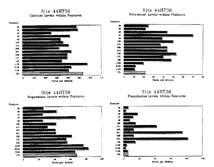 Figure 6. Soil chemistry—44HT36.
components are briefly summarized below. More detailed descriptions of selected features, presented in numerical order, are provided in the section following. A list of all features identified at 44HT37 is provided in Table 2.
Figure 6. Soil chemistry—44HT36.
components are briefly summarized below. More detailed descriptions of selected features, presented in numerical order, are provided in the section following. A list of all features identified at 44HT37 is provided in Table 2.
Two clusters of prehistoric features were evident at 44HT37. In the vicinity of grid point N220 W140, at least three closely-spaced pit features were found. These include Feature 1001, a small secondary burial containing the remains of two individuals, and Features 1002/1005 and 1003/ 1018, two small shell-filled pits both about 2.0 feet in diameter with the latter 1.2 feet deep. A radiocarbon date of A.D. 40 (± 80 years) was derived from charcoal from Feature 1003/1018. Feature 1006, another pit located nearby, may also be part of the cluster; however, the size, depth, and configuration of this feature pit leave open the possibility that it may represent an historic post hole. Feature 1021/1022, which was not excavated, likely represents a filled tree hole.
The other group of prehistoric features at 44HT37 is located roughly ninety feet south from the first cluster, in the vicinity of grid point N130 W160. At least two pits, Features 1024 and 1030, were identified here. These features were larger and deeper than the two shell-filled features in the other cluster and measured roughly 3.0 feet in both diameter and depth. Charcoal recovered from Feature 1024 yielded a radiocarbon date of A.D. 300 (± 70 years). Again, other features located nearby are of possible prehistoric affiliation, although the evidence is ambiguous. Feature 1036 is a little larger in plan than Feature 1038, a
29
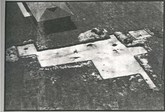 Photo 4. Aerial view of 44HT37.
known historic post hole, but the depths of the two features are the same. Feature 1095, which was not excavated, is of similar size to Feature 1036.
Photo 4. Aerial view of 44HT37.
known historic post hole, but the depths of the two features are the same. Feature 1095, which was not excavated, is of similar size to Feature 1036.
In the northeast section of the site, Features 1097, 1119, 1120, and 1121 were identified. A somewhat scattered group of small pit features, probably originating from the prehistoric period, was also uncovered in the northeastern corner of the excavation area. These include Features 1043, 1054, 1059, 1062, and 1080. A number of additional features of possible prehistoric origin were identified at 44HT37, but were not able to be excavated within the time allocated to the project. Feature 1115, which contained dark brown fill and oyster shell, was situated in the vicinity of the Features 1001, 1002/1005, and 1003/1018. Features 1107, 1108, 1110, and 1093 were located in the vicinity of grid point N190 W150. The latter was represented by a large circular stain of brown loam 3.0 feet in diameter.
Several large tree hole disturbances were excavated at 44HT37, and some of these contained significant amounts of prehistoric debris. Feature 1007/1015, located ten feet west of Features 1001, 1002/1005, and 1003/1018, contained a small deposit of oyster shell near the surface of subsoil, while the remainder of the fill contained a number of prehistoric ceramic sherds (one fragment each of brick and glass were also recovered). The upper layer of Feature 1026/1087/ 1089 contained two fragments of bone tools as well as a sherd and a quartzite flake. This feature is adjacent to Feature 1093, a large, unexcavated pit of possible prehistoric origin. Other probable tree disturbances which were excavated, but yielded little or no artifactual debris, include Features 1023, 1039, and 1042.
A late Middle Woodland Period date for the prehistoric occupation at 44HT37 is indicated by the association of almost exclusively shell tempered, cord and knotted net impressed ceramics, comparable to Mockley ware, with the
30
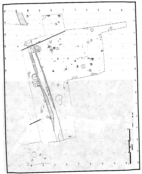 Figure 7. Overall drawing of 44HT37.
31
excavated features. The radiocarbon dates of A.D. 40 (± 80 years) and A.D. 300 (± 70 years) derived from charcoal contained in two of the features support this attribution as well. The presence of pit features at 44HT37 as well as the presence
of a secondary burial suggests a settlement type of some permanency. The size of the settlement remains unclear, although it seems most likely that the two small clusters of features represent non-contemporaneous encampments. The number
of prehistoric artifacts recovered as a whole from the site is low, and few if any prehistoric features were identified in the area separating the two clusters. In general, the archaeological evidence suggests use of 44HT37 during the latter
portion of the Woodland I Period was characterized by repeated, intermittent establishment of long-term encampments by small groups of Native American peoples.
Figure 7. Overall drawing of 44HT37.
31
excavated features. The radiocarbon dates of A.D. 40 (± 80 years) and A.D. 300 (± 70 years) derived from charcoal contained in two of the features support this attribution as well. The presence of pit features at 44HT37 as well as the presence
of a secondary burial suggests a settlement type of some permanency. The size of the settlement remains unclear, although it seems most likely that the two small clusters of features represent non-contemporaneous encampments. The number
of prehistoric artifacts recovered as a whole from the site is low, and few if any prehistoric features were identified in the area separating the two clusters. In general, the archaeological evidence suggests use of 44HT37 during the latter
portion of the Woodland I Period was characterized by repeated, intermittent establishment of long-term encampments by small groups of Native American peoples.
Historic period occupation of site 44HT37 is represented by the remains of two fence lines associated with the nineteenth-century Tabb Farm. These fences are roughly parallel and run east-west. At the far northern end of the excavation area, one fence is represented by Features 1106, 1100/1101, and 1102/1103. Five post holes comprise the other fence, located at N200; these include Features 1047/1069, 1051/1071, 1104/ 1105, 1049/1067, and 1065/1063. Other scattered post holes identified across the site are listed in Table 2. A large modern drainage ditch, Feature 132, ran northwest-southeast through the excavation area.
Description of Features
Feature 1001 was a roughly circular, 2.0' diameter prehistoric pit containing human bone in its upper level (Photo 5; Figure 8). The fill consisted of brown sandy loam about 0.5' deep with inclusions of shell. The feature was bowl-shaped, with
rounded sides and bottom. The human remains contained within the feature represent a secondary burial involving at least two individuals. Recovered from the pit were two right femurs, one from a juvenile and one from a mature individual,
 Photo 5. Detail of human bone in Feature 1001.
and a right tibia which probably belongs to the individual represented by the larger femur. A few other unidentifiable fragments of bone were also recovered. The feature fill contained no other artifacts.
Photo 5. Detail of human bone in Feature 1001.
and a right tibia which probably belongs to the individual represented by the larger femur. A few other unidentifiable fragments of bone were also recovered. The feature fill contained no other artifacts.
Feature 1002/1005 was a small circular prehistoric pit, about 1.8' in diameter. No depth was recorded. Fill consisted of dark grey sandy loam containing snail shells, oyster shell, animal bone, 1 shell tempered, cord-marked sherd, and a small amount of carbonized wood. The feature appeared to have been filled in at least two levels. Layer 1002, which comprised a core area about 0.5' in diameter, appeared to have been deposited after the fill of Layer 1005, which contained the majority of shell, had settled.
Feature 1003/1018 (see Figure 8) was a small, circular prehistoric pit roughly 2.0' in diameter and 1.2' deep with sloping sides and a rounded base. The inner fill of the feature, Layer 1003, was a pocket-shaped deposit, 1.3' in diameter and 0.7' deep. This dark, greyish brown sandy loam contained many oyster shells as well as 13 sherds of shell tempered, knotted net impressed ceramic representing a minimum of two vessels. A radiocarbon date of A.D. 40 ± 80 years (1,910 B.P., Beta-25914) was derived from charcoal in Layer 1003. One Galium (Bedstraw) seed, one Quercus spp. (Oak) acorn cap, and 1 Carya spp. (Thickshell Hickory) nut shell were identified in the analysis of a flotation sample from the feature. The lower fill of the pit, Layer 1018, 32
| Feature No. | Grid Unit | Exc? | Plan | Dimensions | Depth | Interpretation |
|---|---|---|---|---|---|---|
| 1001 | N200 W140 | yes | circular | 2.0' diameter | 0.5' | secondary burial |
| 1002/1005 | N220 W140 | yes | circular | 1.8' diameter | --- | prehistoric pit |
| 1003/1018 | N220 W150 | yes | circular | 2.0' diameter | 1.2' | prehistoric pit |
| 1006 | N230 W150 | yes | circular | 2.0' diameter | 0.5' | prehistoric or historic |
| 1007/1015 | N220 W160 | yes | circular | 5.6' diameter | 3.4' | tree hole |
| 1021/1022 | N230 W150 | no | circular | 1.1' diameter | --- | tree hole |
| 1023/1035 | N180 W140 | yes | irregular | 8.2' by 5.3' | 5.8' | tree hole |
| 1024 | N130 W160 | yes | circular | 2.8' diameter | 2.8' | prehistoric pit |
| 1026/1087/ | N200 W160 | yes | circular | 7.0' diameter | 3.5' | tree hole |
| 1089 | ||||||
| 1028 | N200 W170 | yes | rectangular | 0.8' by 1.3' | 0.3' | historic post hole |
| 1030 | N140 W170 | yes | circular | 2.7' diameter | 2.9' | prehistoric pit |
| 1032 | N180 W150 | no | linear | ----- | --- | modern ditch |
| 1036 | N130 W160 | yes | circular | 1.8' diameter | 0.9' | prehistoric or historic |
| 1038 | N130 W170 | yes | square | 1.0' by 1.0' | 0.9' | historic post hole |
| 1039 | N170 W150 | bisect | circular | 3.2' diameter | 1.1' | probable tree hole |
| 1042 | N250 W150 | quart | ----- | ----- | 4.0' | probable tree hole |
| 1043 | N200 W110 | yes | oval | 2.0' by 1.5' | 0.8' | possible prehistoric pit |
| 1045 | N200 W160 | yes | rectangular | 0.5 by 1.2' | 0.9' | historic post hole |
| 1047/1069 | N210 W120 | yes | rectangular | 0.4' by 1.1' | 0.8' | historic post hole/mold |
| 1049/1067 | N210 W120 | yes | rectangular | 0.5' by 1.3' | 0.9' | historic post hole/mold |
| 1051/1071 | N200 W140 | yes | rectangular | 0.65' by 1.3' | 0.9' | historic post hole/mold |
| 1054 | N240 W90 | yes | circular | 2.0'diameter | 0.7' | prehistoric pit |
| 1059 | N230 W100 | partial | circular | 2.3' diameter | 2.0' | prehistoric pit |
| 1062 | N240 W110 | yes | circular | 2.2' diameter | 1.2' | prehistoric pit |
| 1065/1063 | N210 W110 | yes | rectangular | 1.1' by 1.2' | 0.75' | historic post hole/mold |
| 1074/1076 | N200 W170 | yes | square | 1.2' by 1.2' | 0.75' | historic post mold/hole |
| 1080 | N210 E110 | yes | circular | 1.4' diameter | 0.6' | possible prehistoric pit |
| 1093 | N190 W160 | no | circular | 3.0' diameter | --- | possible prehistoric pit |
| 1097 | N210 W150 | no | circular | 1.3' diameter | --- | possible prehistoric pit |
| 1104/1105 | N210 W130 | no | rectangular | 1.1' by 0.9' | --- | historic post hole/mold |
| 1106 | N250 W170 | no | rectangular | 1.2' by 1.5' | --- | historic post hole |
| 1107 | N200 W160 | no | irregular | ----- | --- | possible prehistoric pit |
| 1108 | N200 W160 | no | irregular | ----- | --- | possible prehistoric pit |
| 1110 | N190 W160 | no | oval | 0.6' by 1.1' | --- | possible prehistoric pit |
| 1113/1114 | N230 W170 | no | rectangular | 0.7' by 0.8' | --- | historic post hole/mold |
| 1115 | N230 W140 | no | oval | 0.65' by 1.1' | --- | possible prehistoric pit |
| 1117/1118 | N210 W100 | no | rectangular | 1.0' by 0.9' | --- | historic post hole/mold |
| 1119 | N230 W110 | no | circular | 1.3' diameter | --- | possible prehistoric pit |
| 1120 | N230 W110 | no | circular | 1.1' diameter | --- | possible prehistoric pit |
| 1121 | N240 W110 | no | circular | 3.1' diameter | --- | possible prehistoric pit |
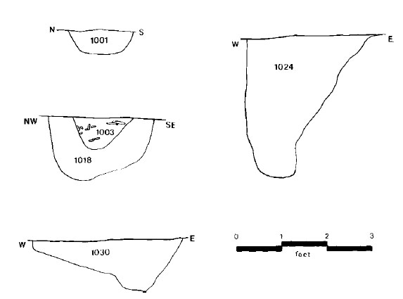 Figure 8. Feature section drawings—44HT37.
consisted of light brown sandy loam with some clay content. This deposit contained 9 shell tempered, knotted net impressed sherds, representing a minimum of 2 vessels. Four small cobbles were found in Layer 1018, situated around the perimeter of the fill of Layer 1003. Although one small fragment of glass was also found in Layer 1018, the feature is believed to date from the prehistoric period.
Figure 8. Feature section drawings—44HT37.
consisted of light brown sandy loam with some clay content. This deposit contained 9 shell tempered, knotted net impressed sherds, representing a minimum of 2 vessels. Four small cobbles were found in Layer 1018, situated around the perimeter of the fill of Layer 1003. Although one small fragment of glass was also found in Layer 1018, the feature is believed to date from the prehistoric period.
Feature 1006 was a small, circular pit, roughly 2.0' in diameter consisting of medium brown sandy loam. It was about 0.5' deep, with irregular sides and bottom. One fragment of fire-cracked rock was recovered.
Feature 1007/1015 was a large circular pit 5.6' in diameter and 3.4' deep, which likely represents a tree hole with various fill deposits. The central part of the feature (Layer 1007) was filled with a dark grey-brown sandy loam which graded to a medium grey-tan sandy loam. This deposit was bowl-shaped with steeply angled sides and a rounded bottom. It contained both prehistoric and historic artifacts. Prehistoric artifacts included 35 shell tempered sherds (19 cord marked, 12 knotted net impressed, 3 plain, and 1 unidentified), four low-fired, untempered lumps of clay, and one quartzite flake. One fragment each of colorless non-leaded glass and brick were also recovered. Also present in the fill were 1 cf. Cyperaceae (Sedge family) seed, 1 Galium (Bedstraw) seed, and some carbonized wood. Layer 1015 was a small, semi-circular deposit of darker fill and oyster shell contained within Layer 1007. The deposit was 1.6' long and extended from subsoil level to a depth of 0.6'.
Feature 1021 was a small, circular deposit of dark grey sandy loam about 1.1' in diameter which appeared to be contained within a larger 34 tree hole disturbance. Within the center of Layer 1012 was a pocket of charcoal (Layer 1022). Neither deposit was excavated.
Feature 1023/1035 was a very large irregularly-shaped feature measuring 8.2' north-south and 5.3' east-west, and consisting of dark brown sandy loam. The feature appears to be a tree hole. Two layers of fill were excavated. The uppermost layer, Layer 1012, was 0.5' deep on its north end, dropping to 2.8' just south of its center, then back up to 0.5' at the south end. One fire-cracked rock spall was recovered. Layer 1035 was the second layer in the large pit, consisting of dark brown sand with many pebbles and some charcoal flecking. At about 0.8' below subsoil this deposit extended 6.0' in diameter. The north wall of the feature sloped to a flat bottom, whereas the south wall was almost vertical. The deposit extended to a total depth of 5.8' below subsoil level.
Feature 1024 (see Figure 8) was a circular prehistoric pit, 2.8' in diameter, consisting of dark brown sandy loam and containing flecks of charcoal, shell, and pebbles. The east side of the pit sloped at about 40°, whereas the west side was nearly vertical. A small, flat bottom was found at a depth of 2.8' below the surface. The feature contained 7 shell tempered sherds: 6 knotted net impressed and one cord marked. A radiocarbon date of A.D. 300 ± 70 years (1,650 B.P., Beta25915) was derived from charcoal samples obtained from this feature. Paleobotanical remains from the feature were quite significant and included the following: a pine cone fragment (Pinus spp.), carbonized wood, 1 thickshell hickory nut fragment (Carya spp.), 1 nut fragment of the Walnut family (Juglandaceae spp.), 1 bedstraw seed (Galium spp.), 1 seed of the Smartweed family (Polygonaceae), and 1 possible maize kernel fragment (Zea mays).
Feature 1026/1087/1089 appears to have been a large tree hole with several layers of fill intruded by a recent drainage ditch. As represented by Layer 1089, consisting of light to medium brown sandy loam, the main feature was 7.0' in diameter and 3.5' deep with a deeply rounded profile. Within this depression were two smaller deposits. Layer 1087, a fill deposit of dark grey and medium brown sandy loam, was 2.0' in diameter and 3.4' deep with steeply sloping sides. A smaller deposit (Layer 1026) of very dark grey sandy loam with oyster shell was contained within the upper 0.7' of Layer 1087. Layer 1026 was 1.0' in diameter. The only deposit within the feature to yield artifacts, Layer 1026 contained 1 shell tempered, knotted net impressed sherd, 1 quartz flake, and two fragments of polished animal bone representing either tools or ornaments.
Feature 1030 (see Figure 8) was roughly circular prehistoric pit, 2.7' in diameter, containing brown sandy loam fill with charcoal flecking. The sides of the pit sloped steeply from the east and gradually from the west to a depth of 2.9'. Artifacts recovered include 1 shell tempered, knotted net impressed sherd and 3 chunks of fired, unshaped sandy paste ceramic.
Feature 1036 was a small, 1.8' diameter, circular pit consisting of brown sandy loam. It was irregularly bowl-shaped with a depth of 0.9'. There were no finds.
Feature 1039 was probably roughly circular; however, the recent drainage ditch appears to have removed half the feature. The original feature was probably about 3.2' in diameter and may represent a tree hole. The profile indicates it was bowl-shaped and 1.1' deep. The greyish-brown sandy loam fill contained no artifacts.
Feature 1042 was a large pit uncovered along the northern edge of the excavation area. Fill consisted of light brown gravelly sand. The portion of the feature excavated revealed a profile approximately 4 feet deep with steep sides and a rounded bottom. There were no finds.
Feature 1043 was an ovate pit measuring 2.0' by 1.5' and consisting of brown sandy loam containing some charcoal flecking. Sides were bowl-shaped with a rounded bottom 0.8' below subsoil level. The feature contained 5 shell tempered sherds, 4 of which are knotted net impressed. The remaining shell tempered sherd showed an unfinished exterior surface with scrape marks over unwelded joins between coils. The 35 feature also yielded one sherd of a fine, sandy paste ceramic with knotted net impressed surface; one fired, unshaped lump of sandy clay; and 2 fragments of fire-cracked rock.
Feature 1054 was a 2.0' diameter, circular pit consisting of medium brown sandy loam with oyster shell inclusions. The walls of the feature sloped slightly to a rounded base 0.7' below the surface. Ceramics recovered from the feature included 15 shell tempered sherds, 14 knotted net impressed and one cord marked, likely representing a maximum of three vessels. An additional shell tempered, cord marked vessel is also represented (the vessel collapsed into numerous tiny fragments in excavation). Two fragments of fire-cracked rock and some carbonized wood was also recovered from the feature.
Feature 1059 was partially obscured by the adjacent baulking. The feature was probably circular, approximately 2.3' in diameter. The sides sloped steeply to a narrow, flat bottom about 2.0' below grade. The fill consisted of grey-brown sandy loam. Inclusions of charcoal flecks were recorded. The pit contained 1 shell tempered, knotted net impressed sherd.
Feature 1062 was a circular pit about 2.2' in diameter. The fill consisted of medium brown sandy loam. The feature was bowl-shaped, with sloping sides and a rounded bottom some 1.2' below grade. Two shell tempered, knotted net impressed sherds were recovered, each representing a single vessel.
Feature 1080 was roughly circular, 1.4' by 1.5' consisting of brown sandy loam with concentrated oyster shell. The pit was 0.7' deep.
Feature 1093 was roughly circular stain, 3.0' in diameter consisting of brown sandy loam. It was not excavated.
Soil Chemistry (Figure 9)
Only one feature, Layer 1002 in Feature 1002/ 1005, had a notably high potassium content. The layer was a small pocket of fill, ca. 1.0' in diameter, containing some oyster shell and charcoal. The same feature also contained significant amounts of phosphorus, indicating the possibility that this was a place where human wastes were deposited.
Several features at HT37 contained significant calcium levels: Feature/Layers 1002, 1003, 1015, 1054, and 1087. Calcium can indicate the presence of decaying shell or bone, and all of the features or layers contained oyster shell in abundance, probably leading to the high readings.
C. Analysis of Prehistoric
Finds (Mary Ellen N. Hodges)
Ceramic Artifacts
Ceramics were overwhelmingly the most abundant type of prehistoric artifact recovered in the excavations, although the entire collection from all three sites totaled only 571 sherds. Apart from radiocarbon dates derived on charcoal from three features at HT36 and HT37, ceramics proved the most informative of the recovered artifacts in determining the cultural affiliation or date of occupation of the three sites. In general, the ceramics indicated a late Woodland I (2000 B.C.-A.D. 1000) date for sites HT36 and HT37. The excavated area designated as site HT55 was largely dominated by historic features relating to a colonial-period occupation. The ceramics associated with the few prehistoric features identified within this area, as well as those incorporated into colonial contexts, are evidence of earlier prehistoric occupations dating from the late Woodland I Period and the Woodland II Period (A.D. 1000-1600).
Study of the ceramic collections from the three sites began by sorting the sherds by size. Only those sherds measuring greater than 2 cm in any direction across the interior or exterior surface were examined further. Analysis proceeded by sorting sherds into groups defined by attributes of temper, paste, and surface treatment. Other attributes relating to manufacturing techniques,
such as rim profile and preparation and vessel shape, were also noted. Vessel size was assessed through an estimate of rim diameters obtained by
36
 Figure 9. Soil chemistry—44HT37.
comparing the curvature of rim sherds against a template on which concentric circles in increments of 2 cm in diameter had been drawn. The collection included very few rim sherds, however, and those fragments which could be measured commonly represented no more than five to ten percent of the total vessel rim. Only one of the sherds examined bore any decoration other than cord or
net marking on the lip, an attribute which is probably more a by-product of shaping the rim with a wrapped paddle than a result of intentional decoration.
Figure 9. Soil chemistry—44HT37.
comparing the curvature of rim sherds against a template on which concentric circles in increments of 2 cm in diameter had been drawn. The collection included very few rim sherds, however, and those fragments which could be measured commonly represented no more than five to ten percent of the total vessel rim. Only one of the sherds examined bore any decoration other than cord or
net marking on the lip, an attribute which is probably more a by-product of shaping the rim with a wrapped paddle than a result of intentional decoration.
Frequencies of wares and types discussed below are based on sherd counts made prior to mending (Table 3). Mends within features were noted in the artifact catalog, but no attempt was made to mend between features. Estimates of the number of vessels represented within each fill layer are provided in the descriptions of features for HT36 and HT37. It should be noted that examination of the sherds suggested, in general, that very few vessels were represented in individual features.
Three ceramic wares, comparable to those previously defined for the Virginia Coastal Plain, were identified in the collections. These included Mockley Ware, a shell tempered late Woodland I Period ceramic characterized by cord marked,
net impressed, and plain surfaces (Stephenson and Ferguson 1963:105-109); Townsend ware, dating from the Woodland II Period and characterized by a shell tempered paste and fabric impressed surfaces (Blaker 1963:14-22); and Roanoke Simple Stamped, another shell tempered ware, dating from the late prehistoric and early Contact period (Blaker 1952; Harrington 1948).
37
 Photo 6. Site 44HT36 during excavation.
| 44HT36 | 44HT37 | 44HT55 | |
|---|---|---|---|
| SHELL TEMPER: | |||
| Cord | 126 | 23 | 100 |
| Knotted Net | 102 | 72 | 58 |
| Fabric | --- | --- | 7 |
| Simple Stamped | --- | --- | 17 |
| Plain | 4 | 7 | 5 |
| Unidentified | 6 | 2 | 18 |
| SANDY PASTE: | |||
| Cord | --- | --- | 4 |
| Net | 2 | 3 | --- |
| Unidentified | --- | --- | 1 |
| UNIDENTIFIED: | 5 | --- | 2 |
| TOTAL | 245 | 107 | 212 |
The vast majority of sherds recovered from the three sites relate to the Mockley series. At HT36, where a total of 245 sherds were recovered in the excavations, 238 were classified as Mockley ware. Of these, surface treatments on 52.9% were cord marked, with 42.9% knotted net impressed, and 1.7% plain, smoothed surfaced (it is likely that the plain surfaced sherds from both HT36 and HT37 represent vessel sections from just below the rim or near the base). Surface treatment on 2.5% of the Mockley sherds was unidentifiable. The remainder of the collection from HT36 consisted of two sherds with a fine sandy paste and knotted net impressed surfaces, and five sherds whose poor condition prevented classification.
The assemblage recovered from HT37 was also dominated by Mockley ceramics. Of a total of 107 sherds, 104 were classified as Mockley ware (Figure 10). Three sherds with a fine sandy paste and knotted net impressed surfaces were also recovered. Among the Mockley ware, 22.1% were cord marked, 69.2% knotted net impressed, 6.7% plain, and 1.9% unidentified.
The collection from HT55 is more diverse (see Figure 10), although Mockley ware again predominated. Of a total of 205 shell tempered sherds, 158 (77.0%) were classified as Mockley ware. Of these, 63.3% were cord marked and 36.7% were knotted net impressed. Seven sherds recovered were assignable to the Townsend series based on their shell tempered paste and fabric impressed surfaces. Seventeen sherds were classified as Roanoke Simple Stamped. Of the remaining shell tempered sherds, five were plain surfaced and eighteen had badly eroded surfaces and could not be definitely assigned to a ware group. The remainder of the ceramic collection from HT55 was comprised of five sherds with a sandy paste, four of which were cord marked and one unidentifiable. Two additional sherds were not assignable to any ware group.
The Mockley ceramics from the three sites conformed fairly well with Stephenson and Ferguson's (1963:103-109) original definition of the ware based on an assemblage from the Accokeek Creek site on the Potomac River in Maryland, as well as with subsequent descriptions of occurrences within the Coastal Plain of Virginia (Egloff and Potter 1982:104; Photo 7). The sherds commonly fractured along joins between coils. Coil manufacture was also indicated by one sherd recovered from HT37 (Feature 1043), with a plain surface and scrape marks which had not completely obliterated the joins between coils. Rim profiles and rim diameters suggested that both jar and bowl forms were present, although only jars were found in the assemblage from HT37 (Table 4). Of four basal sherds recovered, two were subconoidal, one conoidal, and one rounded with a slight flattening. The presence of flat bottomed vessels similar to the "beakers" described by Painter (1977; see also Egloff et al. 1988:28-32) was possibly suggested by one knotted net impressed sherd from HT55 which appeared to originate from the base of the vessel wall, a position where these types of vessels commonly have a thickened, ring-like bulge. Rims on the Mockley ceramics from Hampton University were sometimes thinned or beveled, with the lips either smoothed or marked by cord or net impressions. Vessel wall thickness measured on rim sherds ranged from 0.5 to 0.95 cm. Interior scoring was noted on 13% of the sherds from HT36 and HT37 and less than 1% (one sherd) of those from HT55.
The group of sherds which was identified as Mockley ware within the three assemblages from Hampton was quite variable in paste composition. A small number, about five percent, of the Mockley ware sherds from HT36 and HT37 were characterized by shell temper in a silty paste with no sand admixture. The remainder of Mockley
39
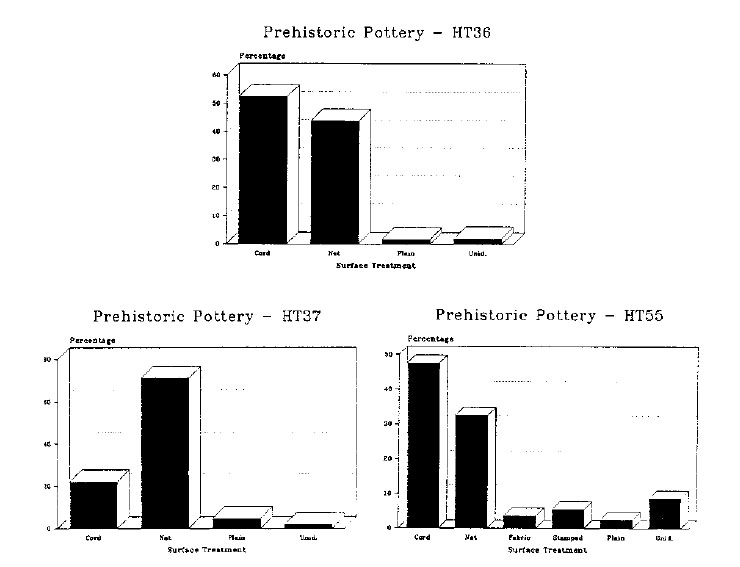 Figure 10. Prehistoric pottery—44HT36, 44HT37, and 44HT55.
| 44HT36 | 44HT37 | |
|---|---|---|
| PROFILE (n=23): | ||
| Straight | 9 | 5 |
| Slightly Everted | 2 | 3 |
| Incurved | 4 | --- |
| RIM DIAMETER (n=10): | ||
| Straight Profile | 34-38 cm | 20 cm |
| Slightly Everted | --- | 26-30 cm |
| Incurved | 10-14 cm | --- |
 Photo 7. Examples of Mockley ware.
ware sherds from these two sites had a paste which contains shell and sparse to moderate amounts of rounded sand grains ranging in size from 0.5 to 3.0 mm in diameter. Approximately two-thirds of the sherds with a sandy paste also contained finer particles of sand which gave the paste a gritty texture on the surfaces, with the exteriors somewhat smoother to the feel than the
interiors. The interior surfaces of many of the sherds with the gritty paste were degraded, with the outer layer of clay peeled off. Some of the sherds had a more compact paste, however. All three paste varieties were also present in the assemblage from HT55, but estimates of the proportions of each were not made.
Photo 7. Examples of Mockley ware.
ware sherds from these two sites had a paste which contains shell and sparse to moderate amounts of rounded sand grains ranging in size from 0.5 to 3.0 mm in diameter. Approximately two-thirds of the sherds with a sandy paste also contained finer particles of sand which gave the paste a gritty texture on the surfaces, with the exteriors somewhat smoother to the feel than the
interiors. The interior surfaces of many of the sherds with the gritty paste were degraded, with the outer layer of clay peeled off. Some of the sherds had a more compact paste, however. All three paste varieties were also present in the assemblage from HT55, but estimates of the proportions of each were not made.
Mockley ware has been described elsewhere as containing, in addition to shell temper, varying amounts of sand, limonite, and organic matter in the paste (Stephenson and Ferguson 1963:104; Egloff and Potter 1982:103). Sherds of mixed sand and shell were noted in assemblages from the Croaker Landing site (44JC70, 44JC71) on the York River (Egloff et al. 1988:26), and sand and organic matter were described as common inclusions within the Mockley ware recovered from James Madison University's (JMU) 41 excavations at the Addington (44VB9) and Sherwood's Forest (44VB92) sites at Great Neck in Virginia Beach (Smith and Andrews 1986). It was also noted by JMU archaeologists that shell was a common inclusion in the paste of those ceramics from Great Neck identified as Mount Pleasant ware, a sand tempered, late Woodland I Period ceramic with cord marked, net impressed, fabric impressed, and plain surfaces defined by Phelps (1983:32).
The meaning of this type of variability in paste is unclear at present. Egloff (Egloff et al. 1988:26,75, 78) concluded that the sherds from Croaker Landing with both shell and sand in the paste most likely represent local variation in the clay source used to produce Mockley ceramics, although he suggested that the paste variety may represent an early temporal phase within Mockley ware. In the Outer Coastal Plain of southeast Virginia, assessment of the meaning of variability in paste is complicated by the fact that shell temper and sand temper traditions have been suggested to have had distinct distributions during the late Woodland I Period. Phelps (1983:32) has noted that Mount Pleasant ware is distributed on inland and coastal sites in the northern half of the North Carolina Coastal Plain. Mockley ware has been found in this region on only a few sites along the Chowan River, and shell temper appears as a common trait only within the Woodland II Period.
Because of variability in paste, differentiating between Mount Pleasant and Mockley wares in southeast Virginia is complicated. The two wares are apparently contemporaneous. Radiocarbon dates on Mount Pleasant components in North Carolina range from around A.D. 200 to 800 (Phelps 1983:32). In Virginia, Mockley ceramics have been dated from A.D. 460 to 875 at the Maycocks site in Prince George County on the James River (Barka and McCary 1977) and from A.D. 260 to 460 at the Great Neck site in Virginia Beach (Egloff et al. 1988:26). Apart from the relative proportions of sand versus shell, vessels identified as Mount Pleasant and Mockley ware at the Addington and Sherwood's Forest sites are virtually identical in terms of manufacturing methods, vessel thickness and form, surface treatment, frequency of interior scoring, and decoration (Smith and Andrews 1986:30-48, 80-98). As they are currently defined, the most striking difference between the two wares is the addition in the Mount Pleasant series of fabric impressed surface treatment (Phelps 1983:32). The Mockley series includes only cord marked and net impressed types. It may be significant that only one out of sixty-eight Mount Pleasant vessels identified at the Addington and Sherwood Forest sites was fabric marked (Smith and Andrews 1986: 30-48, 80-98).
The possibility that mixed sand and shell in the paste of Mockley ceramics represents an early variation in the ware cannot be eliminated on the basis of evidence from the Hampton University assemblages. Two of the radiocarbon dates for the occurrence of Mockley ware at Hampton University are rather early considering other dates which have obtained for the ware. Charcoal recovered from Feature 42 at HT36 yielded a date of A.D. 20 ± 70 (1,930 B.P., Beta 25913). The feature contained thirty-six shell tempered sherds with a sandy paste: thirty cord marked, three knotted net impressed, one plain surfaced, and two unidentified. One net impressed sherd with a sandy paste was also included. At site HT37, a date of A.D. 40 ± 80 (1,910 B.P., Beta-25914) was obtained on charcoal from Feature 1003, which contained all sandy paste, shell tempered sherds: nine knotted net impressed and four plain surfaced. The plain surfaced sherds probably represent a single vessel base. A third radiocarbon sample on Mockley ware yielded a later date, however. The date was obtained on Feature 1024 at HT37, which yielded ceramics similar in paste to those from the other two dated features. Charcoal from Feature 1024 was dated to A.D. 300 ± 70 (1,650 B.P., Beta 25915). The feature contained five shell tempered sherds with a sandy paste, four knotted net impressed and one cord marked, and two knotted net impressed sherds with a fine sandy paste.
The two earlier radiocarbon dates obtained from the prehistoric sites at Hampton University 42 contribute to a growing body of evidence that a shell tempered ceramic tradition appeared in the Coastal Plain of Virginia during the middle portion of the Woodland I Period (Egloff et al. 1988:30). Painter (1977) has identified an early shell tempered ceramic in the outer Coastal Plain of southeastern Virginia and northeastern North Carolina which, because of its similarity to Marcey Creek ware, is believed to date ca. 1200 B.C. At the Currituck site in North Carolina, Painter has obtained radiocarbon dates ranging from 810660 B.C. on sherd, sand, or shell tempered, flat-bottomed "beaker" vessels with either cord, net, or fabric impressed surfaces (Painter 1978). The early dates derived from the Hampton University sites also lend support to Custer's (1989:276277) suggestion that the Mockley ceramic tradition spread from south to north along the Atlantic coast, with its origin in the outer Coastal Plain of southeastern Virginia.
Very little can be said about the Late Woodland Period ceramics recovered from site HT55. No rim or basal sherds or decorated fragments were included among the seven fabric impressed and seventeen simple stamped sherds in the collection. These shell tempered ceramics were generally characterized by a silty paste. Simple stamping was accomplished with both flat, thong-like and more fibrous materials.
The small number of Townsend and Roanoke Simple Stamped ceramics at HT55 does suggest rather limited use of the site during the Late Woodland Period. In fact, very few, if any, features associated with this period were identified at the site. Townsend ware has been radiocarbon dated in Virginia from A.D. 945 to A.D. 1590 (MacCord 1965; Outlaw 1978; Potter 1982:239-242; Waselkov 1982:286-287). Roanoke ware is suggested to have appeared very late within the prehistoric period. The ware has been found in early colonial contexts at Fort Raleigh on Roanoke Island, North Carolina (Harrington 1948) and at what is believed to be the site of a colonial trading post at Kecoughtan in Hampton. A radiocarbon date of A.D. 1515 was obtained by Painter from a pit at Great Neck in Virginia Beach containing mainly Roanoke ware (Fleming 1981).
In addition to vessel fragments, the ceramic collection from HT37 contained several fired, unshaped clumps of clay which may be waste from ceramic manufacturing activities. The clay is generally of a sandy texture. None of the clumps was observed to contain any shell inclusions. The debris was recovered from Features 1007, 1030, and 1043. The latter feature also yielded the sherd, described above, on which the coil joins had not been obliterated.
The only other prehistoric ceramic artifact recovered in the excavations at Hampton University is a shell tempered, Townsend ware rim sherd which was pressed into the face of a historic ceramic floor tile before the tile was fired. The exterior face of the sherd is visible and is decorated just below the lip with two bands of vertically-oriented notches which seem to have been formed by pressing a short length of dowel into the clay.
Lithics
The sites at Hampton University are remarkable for the very small number of lithic artifacts contained in the assemblages. The collection from HT36 contained only six flakes, three each of quartz and quartzite. Two of these bear cortical surfaces. One quartz biface was recovered from Feature 73, considered to be an historic feature. The artifact was a preform to a small side-notched point. Feature 4 yielded a quartzite mano. The remaining lithic artifacts from the site were a quartzite cobble core and a few fragments of fire-cracked rock.
Site HT37 yielded only two flakes, one each of quartz and quartzite. Aside from a few fragments of fire-cracked rock, the only other lithic artifact recovered was a fragment of a small quartzite projectile point with a contracted stem, which may be of the Rossville type (Ritchie 1971; Stephenson and Ferguson 1963). Both the stem and blade are broken. Width at the shoulder is 43 2.43 cm. Radiocarbon dates from the northeastern United States compiled by Gleach (1985) suggest the Rossville point was in use from about 500 B. C. to A.D. 400.
A total of 340 flakes was recovered from HT55. Of these 267 are quartz (78.5%), 63 quartzite (18.5%), and two jasper (0.6%). The remaining flakes included one each of green slate and sandstone. Also recovered were six flakes of a distinctive material referred to as oolitic quartzite (Bottoms 1968), characterized by quartz grains embedded in a chalcedony-like matrix. Two hundred sixty of the flakes in the assemblage (254 quartz, six quartzite) were recovered from Feature 407, a large shallow basin which also yielded the remnant of a quartzite core and the tip of a quartz projectile point. Three Mockley cord marked sherds were also recovered from the feature.
Five additional bifaces were recovered at HT55. These, which were in an early stage of reduction, include three of quartz and one of quartzite. Feature 33 yielded a fragment of a small, unidentifiable quartzite projectile point, the base of which had been broken. Two modified flake tools were identified in the assemblage, one each of quartz and quartzite.
The excavated assemblage also included four ground stone tools. One is a possible metate fragment of quartzite sandstone which has been fire-cracked. Two other artifacts, which were recovered from the same historic context, appear to have been used to abrade other tools. One was a rectangular block of sandstone, approximately 3 cm long and 2 cm wide, with two parallel linear grooves incised on a face and an edge. The other artifact was a cobble of fine-grained sandstone about 9 cm long, 4 cm wide, and 1 cm thick. One face of the cobble had been abraded to a very smooth surface, and one edge had been squared off from abrading. The remaining ground stone artifact was a schist cobble, roughly 7 cm in diameter with a maximum thickness of 2.3 cm, recovered from Feature 203. The cobble has shallow pecked depressions on each face, suggesting its use as an anvil stone. The feature also yielded 19 Mockley sherds, 17 cord marked and 2 plain surfaced.
Three notable artifacts were recovered at HT55 while cleaning the surface of the subsoil after removal of the plowzone. One was a tear-drop-shaped, bifacial endscraper of quartz, 4.85 cm long with a maximum width and thickness, respectively, of 2.37 cm and 0.75 cm. A small, stemmed, quartzite projectile point of the Savannah River type (Coe 1964) was also recovered. Small variants of the Savannah River type have been radiocarbon dated to about 2000 B.C. at the Plum Nelley site (44NB128) in Northumberland County, Virginia (Potter 1982:276-329). The dimensions of the point from HT55 were: total length 4.13 cm; shoulder width 2.91 cm; stem length 1.07 cm; stem width at base 1.50 cm; and maximum thickness 0.74 cm. The remaining artifact was a triangular-shaped biface of quartzite, probably a projectile point preform. The tip has been chipped slightly, but the existing length was 4.35 cm. Basal width and maximum thickness were, respectively, 2.50 cm and 1.11 cm.
Bone and Shell Artifacts
Fragments of two unidentifiable polished bone tools were recovered from Feature 1026 at HT37, which also yielded one Mockley knotted net impressed sherd. At HT55, one tubular shell bead was recovered.
44Chapter 6.
The Historic Site—44HT55
A. Description of the
Features (Photo 8)
A detailed description of each of the several hundred individual features found at site HT55 would be unnecessary—an exercise in drudgery for the writers and a sure cure for insomnia for the readers. The completed records for each of these features and their contexts are included in a separate volume on file at Colonial Williamsburg's Department of Archaeological Research. The field drawings and photographs are also on file at the D.A.R.
There are certain features, however, which are an integral part of the interpretation of the site and the reader may be served by having detailed descriptions. These include features comprising the five structures, the well, trash pits, and slot fence lines.
Structure A
The remains of Structure A were composed of a brick-lined cellar and numerous post holes (see Figures 11 and 12). The post holes represent the placement of three transverses, an east, central, and west, around which the two-bay building was constructed. The post holes will be described in pairs, beginning with the eastern transverse.
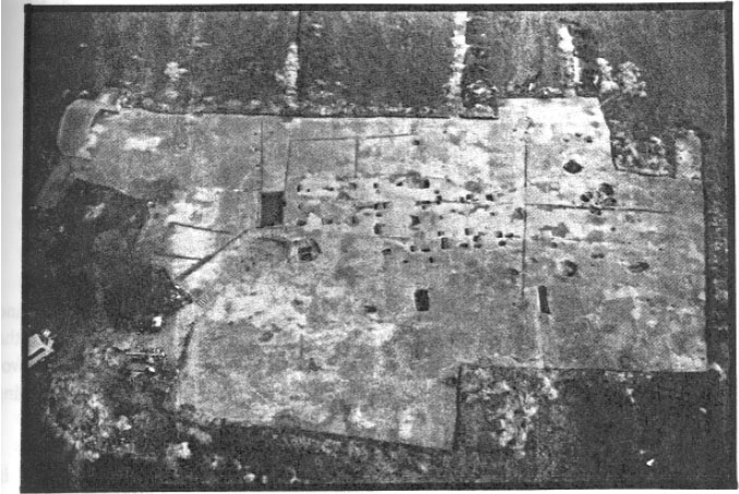 Photo 8. Aerial view of 44HT55.
 Figure 11. Detail of Structure A.
Feature 5 was the northeast post hole of Structure A, measuring 2.65' in length, 2.41' in width, and 1.25' in depth. It was roughly rectangular, containing brown sandy loam fill and post mold 76. The fill also contained a small amount of brick, a speck of mortar, and a little charcoal flecking. The post mold measured 0.85' by 0.60' by 1.17' and was rectangular as well. Its fill was a dark brown sandy loam containing some bricketage, mortar, and charcoal.
Feature 8 once contained a post which was a repair/replacement for the one previously standing in Feature 5, so indicated by its intruding the latter feature. The roughly rectangular post hole measured 2.4' by 1.8' x 0.72' and contained a sandy clay fill with some brick, mortar and charcoal. The post mold, Feature 9, measured 0.84' by 0.60' by 0.72', was also rectangular, and contained dark brown sandy loam fill.
The southeastern post hole group is, of course, the corresponding set for the east transverse. Post hole 363, with post mold 364, are the original southeast structural posts for Structure A. The post hole was large, measuring 3.0' by 2.5' by 1.56', rectangular, filled with mottled brown sandy loam, and containing some shell and charcoal. The post mold, Feature 364, was 0.7' square and 1.6' deep. It contained only dark brown sandy loam with no apparent inclusions.
Post hole combination 132/133 was the repair post for 363/364, but was not intrusive. Feature 132 was a square hole with straight sides to a depth of one foot, then sloping towards the center, below the post mold. It measured 1.7' by 1.7' by 1.25', containing mottled fill with shell, brick, mortar, and charcoal inclusions. The post mold (133) was also rectangular (.85' by 0.55') with a flat base resting on a clay cap of redeposited subsoil. The fill was a clay and sandy silt combination with brick and charcoal inclusions.
The original post hole for the north central traverse was Feature 347. No mold was visible,
47
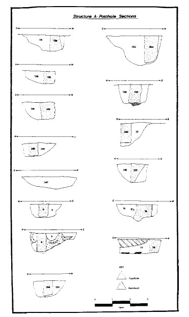 Figure 12. Posthole sections—Structure A.
48
its having been obliterated by a later repair. The post hole was large, measuring approximately 3 feet by 2 feet, but extending only 0.7' below subsoil.
Figure 12. Posthole sections—Structure A.
48
its having been obliterated by a later repair. The post hole was large, measuring approximately 3 feet by 2 feet, but extending only 0.7' below subsoil.
Replacement post hole/ mold 344/345 intruded 347 and was probably a later repair. Post hole 347 was roughly 2.0' square and 0.75' in depth. It was intruded by post hole 341, a yet later repair. Post hole 344 contained brown sandy loam fill with heavy orange clay mottling and some shell bits. Post mold 345 was about 0.8' by 0.6', rectangular with a depth of 0.7'. It was filled with dark brown sandy loam.
Post hole/post mold 341/342 appears to be a subsequent repair to the north central traverse of Structure A. The post hole consisted of brown sandy loam mottled with clay and loam. It measured 2.1' by 1.8' and was about 1.0' in depth, containing some shell and brick inclusions. Post mold 342 was roughly 0.7' square and also about 1.0' deep. This post mold contained a Harrington farthing minted in 1613 or 1614.
The southern corresponding post for the central traverse on the south side of Structure A was represented by Feature 316, which was about 1.8' square and 1.1' deep. Its fill contained a brown sandy loam mottled with clay and some brick bits and charcoal flecks. Post mold 317 was large, about 1.0' square, though partially obliterated by later repair post hole 30/330. Post hole 30 consisted of grey-brown sandy loam and measured 1.7' by 1.7' by 1.3'.
The north original post hole/post mold for the western traverse was composed of Features 131/ 129. The post hole (131) was rectangular, measuring 1.7' by ca. 2.0', the western edge having been destroyed when repair post hole/post mold 126/128 was placed. Post mold 129 consisted of dark brown loam and measured 0.5' square. Repair post hole 126 measured 1.9' by 1.5' and contained a 0.5' square post mold (128).
The southern post hole of the same traverse consisted of original post hole 77 with post mold 79, and repair post hole 74 with its post mold 76. Post hole 77 measured 2.7 by 2.4 by 0.9', was roughly square, and had vertical sides and a flat bottom. The fill was mottled light and dark grey sandy loam containing a significant number of seventeenth-century artifacts, shell, bricketage, mortar fragments, and charcoal. It was the only original post hole in Structure A which contained artifacts in large numbers. Its post mold, Feature 79, consisted of dark grey sandy silt, was roughly 0.65' square and 0.75' deep. It, too, contained numerous artifacts and other material. The repair post hole, 74, had sloping sides and a flat bottom under the post mold (76). The hole measured 2.2' by 1.6' by 0.7' and contained grey sandy silt/loam mottled with orange clay, some artifacts (primarily iron), shell, bricketage, mortar, and charcoal inclusions. The post mold (76) was round, with a diameter of 0.8' and 0.9' in depth, consisted of dark grey sandy silt and contained some artifacts as well as shell, brick, and charcoal in small amounts.
Post hole/post mold 353/354 was located midway between the post holes making up the eastern traverse. It may have held a gable post next to the cellar, but since no corresponding post hole was found on the western end of the structure it is more likely that it served as a fireplace support. A passage was added when the cellar was constructed. Post hole 353 was roughly square, ca. 2.0' by 2.0' by 0.95', and filled with brown sandy loam. Its post mold (354) was rectangular (0.5' by 0.6') and about 0.85' deep, filled with dark brown sandy loam. No inclusions were noted.
Structure B
Structure B was also a traverse-raised, two-bay dwelling located only a few feet to the west of Structure A (Figures 13 and 14). It exhibited, as did Structure A, signs indicating several repair episodes. A description of the post holes and mold associated with Structure B will begin with the southernmost traverse.
Post hole/post mold complex 320/321 was located at the southeastern corner of Structure B. The post hole was rectangular, 2.5' by 2.0' and 1.8' in depth. The fill consisted primarily of
49
 Figure 13. Detail of Structure B.
orange clay with tan, grey and brown sandy loam mottling. There were no artifacts or inclusions in the fill. The post mold was about 0.6' square, filled with dark grey sandy loam. No repairs were evident.
Figure 13. Detail of Structure B.
orange clay with tan, grey and brown sandy loam mottling. There were no artifacts or inclusions in the fill. The post mold was about 0.6' square, filled with dark grey sandy loam. No repairs were evident.
The corresponding post hole/post mold on the southwestern corner of the structure was designated Feature 306/307. The post hole measured 3.2' in length and at least 2.7' in width, with a depth of 2.1' It was, however, intruded on the east side by a repair post and a twentieth-century cow burial. The fill was primarily orange clay (redeposited subsoil) mottled with brown sandy loam. Some bricketage was found in the fill, but little other cultural material. Its post mold (307) was roughly 0.7' square, 1.8' deep, and contained dark brown sandy loam with some brick bits and charcoal. Repair post hole/ post mold complex 303/304 intruded the northeast corner of 306 and was in turn intruded by the modern cow burial. Feature 303 was 1.7' in length and probably about 1.5' wide, with a depth of about 2.0'. The post mold, 304, was 1.8' deep, roughly 0.8' square and filled with dark brown sandy loam with some brick and charcoal bits.
East-central post hole 276 measured 2.6' by 3.0' and was 1.9' deep. It was intruded on the east side by a slot fence trench connecting Structures A and B. The fill was a mixture of loam and clay with shell, brick, and charcoal inclusions. The post mold (277) was about 0.8' square and 1.8' deep. Its dark sandy loam fill contained only nails.
The west-central framing post hole/mold, 291/ 292, was intruded by Features 289/288 on the north side. Post hole 292 was rectangular, measuring 3.3' by 3.0', had steeply sloping sides and a flat bottom, two feet in depth. The fill consisted of alternating bands of clayey redeposited subsoil and sandy loam, containing aboriginal pottery, tin-enamelled earthenware, case bottle glass, lead shot, and 7 nail fragments. A nearly whole brick was embedded in the upper part of the fill.
50
 Figure 14. Posthole sections—Structure B.
The post mold, 291, was circular, 0.8' in diameter, containing brown sandy loam fill and bricketage, along with a nail and a domestic pipe bowl fragment. The post mold extended to the bottom of the post hole.
Figure 14. Posthole sections—Structure B.
The post mold, 291, was circular, 0.8' in diameter, containing brown sandy loam fill and bricketage, along with a nail and a domestic pipe bowl fragment. The post mold extended to the bottom of the post hole.
Repair post hole 289 was smaller than 291, roughly 1.6' square and 1.4' deep. The south edge was steeply sloping, whereas the north sloped more gently to a flat bottom. The fill was hard-packed clayey redeposited subsoil with tan sandy loam mottling. Two nails, one piece of lead shot and a fragment of daub were recovered from the section. Post mold 288 consisted of dark brown loamy fill, was circular, about 0.7' in diameter, 1.3' deep, with a flat bottom extending about 0.15' 51 below the bottom of the post hole. The mold contained two nails.
The north-east post hole, 163, measured 3.0' by 2.6' was rectangular and intruded by repair post hole 162 on its south end. The fill was 1.6' deep, mixed orange and yellow clay mottled with light brown sandy loam, containing aboriginal pottery, a nail, and two brick fragments, shell, and charcoal. The post mold, 165, was roughly 0.8' square, also 1.6' deep, consisted of dark brown sandy loam containing no artifacts, but some brick and charcoal flecks.
The post hole/mold complex intruding the southern part of the original post hole were Features 160 and 162. Feature 160 was roughly 2.0' by 1.6' by 0.9', rectangular, consisting of mixed clay fill, and containing aboriginal pottery and two roofing tile fragments. The post mold (162) was also roughly rectangular, 1.0' by 0.8', consisted of dark grey sandy loam fill and contained a fragment each of aboriginal pottery, tin-enamelled earthenware, two nails, and a domestic pipe stem fragment.
The northwest post hole complex (472/473) was intruded by repair post hole 470. Feature 472 was roughly 2.8' square, 1.6' deep, consisting of brown sandy clay and containing one nail, and some brick and charcoal fragments. The post mold (473) was about 0.8' square, 1.7' deep, flat-bottomed and contained fill consisting of dark brown sandy loam containing two nails and a faunal bone fragment. The intrusive repair post hole complex 470/471 obscured the southeast corner of 472/473.
Post hole 470 was irregularly-shaped, measuring 2.4' by 1.7' and 1.7' in depth. The fill consisted of brown sandy loam mottled with orange clay containing one fragment of container glass and some brick and charcoal fragments. The post mold (471) was roughly 0.4' square, also 1.7' deep and consisted of brown sandy loam fill containing one nail fragment. Both the hole and the mold had relatively flat bottoms.
Post hole/mold 115/116 was located between the two southern framing posts and probably served as a fireplace support as did Features 353/ 354 in Structure A. Post hole 115 measured 2.1' by 1.7'and was 2.02' deep. Both sides were steeply sloping and the bottom flat. The post mold (116) was rectangular, 0.6' by 0.7', resting on the bottom of the hole cut.
Structure C
Structure C (Figures 15 and 16) was probably the first building erected at HT55. It was rectangular, approximately 20' by 40', oriented east-west. The building consisted of eight post hole/ post mold complexes forming three long bays.
The northernmost post hole of the eastern traverse was designated Features 271/270. The post hole was rectangular, measuring 2.75' by 2.1' and 1.05' in depth.
It had steeply sloping sides and a flat bottom. Fill was re-deposited subsoil mottled with topsoil mixed when the post hole was dug. No artifacts or inclusions were evident. The post mold (270) was nearly square, 0.8' by 0.7', and also 1.05' in depth. Its fill was dark brown sandy loam and was sterile except for one brick fragment.
Post hole/post mold 283/284, located at the southeastern corner of Structure C, were severely truncated by the later east-central framing post for Structure B. The north-south measurement for 283 was 2.2', but the east-west length was unattainable. The post mold, 284 was 0.7' north-south and was probably square.
Post hole/mold 138/139 was roughly rectangular, 2.45' by 2.18', and was 1.0' deep. The fill was re-deposited orange clay subsoil with brown sandy loam lenses. Artifacts recovered were one fragment of aboriginal pottery, a flake, and a fragment of English flint. The post mold (139) was 0.8' in diameter, circular, and consisted of tan sandy clay fill mottled with brown sandy loam. One nail, one straight pin, and a glass linen smoother handle were recovered from the 1.0 feet of fill.
Feature 295 was probably roughly circular, measuring 2.4' in diameter, but had been subsequently intruded on the west side by the west-central framing posts from Structure B. The post
52
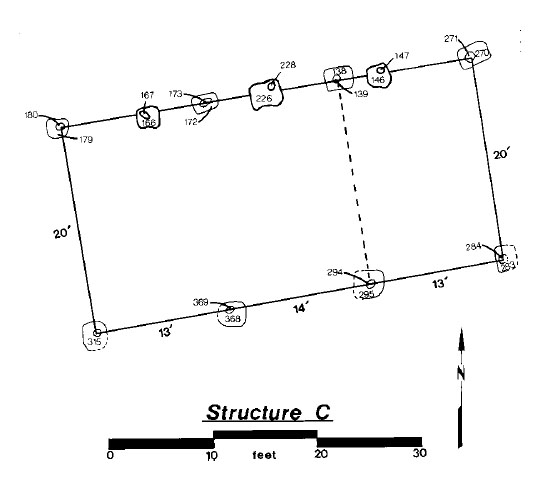 Figure 15. Detail of Structure C.
mold (294) was also roughly circular, measuring about 0.9' in diameter and filled with brown sandy loam. Both the hole and mold were about 2.3' deep.
Figure 15. Detail of Structure C.
mold (294) was also roughly circular, measuring about 0.9' in diameter and filled with brown sandy loam. Both the hole and mold were about 2.3' deep.
Post hole 172 was roughly rectangular, measuring 2.7' by 2.3' with a depth of 1.6'. The sides of the post hole were basically straight, sloping toward the base to a flat bottom. A lens of light grey sand was found beneath the post hole. The fill was otherwise typical and contained no artifacts or inclusions. The post mold, 173, was roughly 0.6' square with very dark grey sandy loam fill. There was a clay deposit below the post hole, raising it 0.3' above the bottom of the post hole. No artifacts were recovered, but inclusions of brick bits were noted.
Feature 368, the eastern post hole, was roughly 2.3' square and contained brown sandy loam mottled with orange clay fill. Shell and charcoal inclusions were recorded, but no artifacts were recovered. The post mold, 369, was 0.6' square and contained dark brown sandy loam fill. No artifacts were found.
The northwest corner post hole, Feature 179, was somewhat smaller than the others, measuring about 2.0' square. The bottom of the post hole, about 1.4' below the surface was flat and rounded in plan. The fill was re-deposited subsoil
53
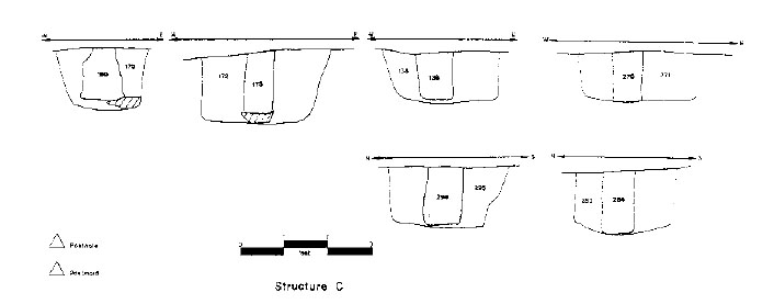 Figure 16. Posthole sections—Structure C.
mottled with brown sandy loam, containing no artifacts or inclusions. The post mold, 180, was rectangular, 0.65' by 0.50' and extended to a depth of 1.06'. Its dark brown sandy loam fill contained one nail and a roofing tile.
Figure 16. Posthole sections—Structure C.
mottled with brown sandy loam, containing no artifacts or inclusions. The post mold, 180, was rectangular, 0.65' by 0.50' and extended to a depth of 1.06'. Its dark brown sandy loam fill contained one nail and a roofing tile.
The southeastern post hole for Structure C was Feature 315. Unfortunately, it was almost entirely obliterated by the later southeast corner post of Structure D.
Structure D
This southeastern corner post hole, Feature 279, was part of Structure D (Figures 17 and 18), a building which obviously postdated the abandonment of Structure C. The post hole was nearly square, 2.2' by 2.1', and intruded by Structure E post hole 265 on its southern edge. It was 1.85' deep consisting of brown sandy loam mottled with orange clay and containing three nails, a domestic pipe stem, faunal bone and some bricketage inclusions. The post mold (280) was 0.7' square, contained dark brown sandy loam with orange clay inclusions, and was 1.85' in depth. One wrought nail and a sliver of wood were recovered from the fill.
Post hole/mold 169/170 once represented the northeast corner post for the structure. It was irregularly shaped, measuring 2.5' by 2.0' with a depth of 2.0'. Its fill was the typical orange sandy clay re-deposited subsoil with brown sandy loam mottling, containing only one aboriginal pottery sherd and a few brick and charcoal bits. The post mold, 170, was ovate, 1.0' by 0.6', and also attained a depth of 2.0'. Its fill consisted of dark brown sandy loam and contained, in addition to brick, shell, and charcoal inclusions, nails, case bottle glass, English flint, a straight pin, and unidentified iron and lead objects. The presence of this material in the post mold fill may indicate that the post was pulled up, allowing surrounding debris to enter the resulting hole.
The northern post hole/mold in the middle traverse, Feature 149/150, was a large, nearly square post hole, measuring 3.0' by 3.08', attaining a depth of 1.8'. The post hole's sides were straight and its base flat. The fill was re-deposited subsoil mottled with brown sandy loam containing, in addition to brick and charcoal inclusions, two sherds of aboriginal pottery, a fragment of container glass, two nails, a copper alloy thimble, a bit of bog iron, and a faunal bone. The post mold, 150, was rectangular, 1.2' by 0.9', 2.1' in depth, consisting of light brown and grey loam mottled with tan sandy clay, and containing three aboriginal pottery sherds, two nails, a domestic pipe bowl and stem, and six fragments of unidentified iron.
The corresponding post hole/mold in the central traverse, Feature 337/336, was approximately the same size and shape as 149/150, measuring 3.0' by 2.9' and 2.0' deep. The fill was also redeposited subsoil mottled with brown sandy loam and contained a great number of historic artifacts:
54
 Figure 17. Detail of Structure D.
 Figure 18. Posthole sections—Structure D.
55
three aboriginal pottery sherds, two blue coarseware pieces, one faience sherd, one Westerwald fragment, twelve nails, one straight pin, two fragments of daub, faunal bone, brick, shell, charcoal, and an assortment of domestic and imported tobacco pipe stems and bowls. The post mold, 336, was surprisingly small, measuring only 0.6' by 0.4', filled with dark grey sandy loam and containing a case bottle fragment, a nail, and two faunal bones. The large amount of cultural debris found in the post hole was somewhat unexpected. There seem to be two explanations for the material, the structure was originally constructed a long enough time after Structures C that trash had built up around the site and was subsequently deposited in the hole, or the post hole was disturbed by later post hole 299.
Figure 18. Posthole sections—Structure D.
55
three aboriginal pottery sherds, two blue coarseware pieces, one faience sherd, one Westerwald fragment, twelve nails, one straight pin, two fragments of daub, faunal bone, brick, shell, charcoal, and an assortment of domestic and imported tobacco pipe stems and bowls. The post mold, 336, was surprisingly small, measuring only 0.6' by 0.4', filled with dark grey sandy loam and containing a case bottle fragment, a nail, and two faunal bones. The large amount of cultural debris found in the post hole was somewhat unexpected. There seem to be two explanations for the material, the structure was originally constructed a long enough time after Structures C that trash had built up around the site and was subsequently deposited in the hole, or the post hole was disturbed by later post hole 299.
The northern post hole (Feature 223) in the western traverse was a large, 2.8' square feature with a post mold, 224, in its southwest corner. The 1.45' deep post hole contained re-deposited subsoil mottled with brown sandy loam fill and numerous seventeenth century artifacts, similar to 149. The post mold was irregularly shaped, measuring 1.1' by 1.0' with a depth of 0.8', substantially less than that of the post hole. The fill was grey sandy loam mottled with orange clay containing four nails, an iron buckle, daub, and bone. Shell, brick and charcoal inclusions were also noted.
The southwest corner post hole in Structure D, Feature 312, was a large, 2.5' roughly square post hole almost entirely obscuring the southwest corner post hole for Structure C. The post hole was 1.7' deep consisting of orange, tan, grey, and dark brown loam mottled with light tan silt, and containing such historic artifacts as coarseware fragments, Westerwald, nails, window lead, flint, pins, bog iron, pipe bowls, pipe stems, iron, bone and oyster shell. The post mold, 313, was relatively small, measuring 0.7' by 0.6', and almost square. Its dark brown loamy fill contained nails, copper alloy tacks, bone, shell, chalk, pipe stems and bowls, and a possible iron knife blade. It, too, was approximately 1.7' deep.
Feature 349 was a post hole located on the middle east end of the structure, probably serving as fireplace support post. It was irregularly shaped, approximately 2.2' by 1.9', consisting of 0.8' of brown sandy loam fill containing two nails, one case bottle fragment and two faunal bones. The post mold, 350, was circular, 0.6' in diameter and consisted of dark brown sandy loam fill containing two nails, one faunal bone, and oyster shell.
Structure E
The final building, Structure E, was the last to be built at HT55, replacing Structure D when it apparently fell into disrepair (Figures 19 and 20). It shares no walls or post holes with the previous buildings, was ca. 20' wide, 24' long, and made up of six framing post holes. This building appears to have been side-raised, rather than traverse-raised like the majority of the others. Two small off-set post holes on the western end of the building may indicate a fireplace.
Feature 219 was the northeastern corner post hole for the structure. It was almost square, measuring 2.5' by 2.2' and containing 1.5' of orange clay mottled with brown sandy loam fill. Two aboriginal pottery sherds, two nails, a flake, and a large amount of bricketage was recovered from the fill. The post mold, 221, was 0.8' circular, containing brown sandy loam, but no artifacts.
The southeast corner post hole, Feature 265, was rectangular, measuring 2.2' by 2.4'. The bottom of the hole was square and flat some 1.5' below the surface. The brown loam mottled with orange clay contained shell, brick, and charcoal inclusions along with a considerable number of seventeenth-century artifacts (see Artifact Catalog, Volume II). The post mold, 266, was circular, 0.7' in diameter, consisted of dark brown silt, and contained a case bottle fragment, nails, pins, pipe stems, a pipe bowl fragment, and bone. It, too, was approximately 1.5' deep, with a flat bottom.
North-central framing post hole 157 measured 2.1' by 2.6', was rectangular and 1.65' in depth.
56
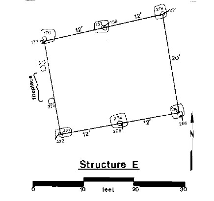 Figure 19. Detail of Structure E.
 Figure 20. Posthole sections—Structure E.
57
The sides were steep and straight, the bottom flat. The fill consisted of light yellowish brown clay mottled with brown, grey and black sandy loam. Artifacts recovered were numerous, including aboriginal pottery, 21 nails, daub, brick fragments, imported and domestic pipe stems and bowls, and an unidentified iron object. The mold, 158, was 0.9' circular, with slightly irregular sides and a flat base resting on about 0.2' of packed clay. Artifacts recovered included widow glass, 6 nails, brick, and bone.
Figure 20. Posthole sections—Structure E.
57
The sides were steep and straight, the bottom flat. The fill consisted of light yellowish brown clay mottled with brown, grey and black sandy loam. Artifacts recovered were numerous, including aboriginal pottery, 21 nails, daub, brick fragments, imported and domestic pipe stems and bowls, and an unidentified iron object. The mold, 158, was 0.9' circular, with slightly irregular sides and a flat base resting on about 0.2' of packed clay. Artifacts recovered included widow glass, 6 nails, brick, and bone.
South-central post hole 299 was 3.0' by 2.4' rectangular, consisting of light brown sandy loam mottled with clumps of yellow clay. The sides were straight and the bottom flat. Artifacts recovered included 15 nails, one window came, an English flint, one clothing pin, mortar, brick fragments, shell, and domestic and imported smoking pipe fragments. The post mold, 298, was 1.0' by 0.9' by 1.6', consisting of loose, soft, dark brown sandy loam. A depression in the bottom of the post hole suggests that the post was driven past the bottom of the hole or sank under the weight of the building. Artifacts recovered included aboriginal pottery, clothing pins, 2 domestic pipe bowl fragments, and 2 domestic pipe stem fragments.
The northeast corner post hole, Feature 176, was nearly square, measuring 2.4' by 2.3' with a depth of 1.6'. Its sides were straight and its bottom flat; the fill consisted of orange sandy clay mottled with tan and grey sandy loam. Artifacts recovered from the feature included two aboriginal pottery sherds, redware, case bottle glass, nails, flint, an iron clothing hook, imported and domestic pipe stems, with brick, shell, and mortar inclusions. The post mold, 177, was about a foot square, contained dark brown sandy loam fill, but only one nail and another clothing fastener. Brick, shell, and charcoal inclusions were also recorded.
Two small post holes, Features 373 and 374, were located between the two western support posts. Both of these post holes were small and did not contain post molds. They probably functioned as supports for an entrance or possibly a chimney. Post hole 373 was about 0.9' square and only 0.7' deep. The fill was grey/tan sandy loam with orange clay mottling and contained a nail, brick fragments, and oyster shell. The bottom appeared to be slightly rounded. Post hole 374 was slightly rectangular, 0.7' by 0.9', and only 0.35' in depth. The fill was identical to that of 373 and its bottom was also slightly rounded. Artifacts recovered included six fragments of tin-enamelled earthenware, a nail, and an imported pipe stem.
Non-Structural Features
In addition to the five buildings erected at 44HT55 during the first half of the seventeenth century, several other non-structural features that require detailed descriptions. These include the two large trash pit just north of Structure A (Trash Pits A and B), the well, Trash Pits C, D, and E, the slot fence trenches, and the boundary/drainage ditch in the north central area of the site. Features or layers making up a larger entity were given so-called "macro-feature" designations and were considered related in the artifact analysis.
Trash Pit A
First uncovered by the Kicotan Chapter of the Archaeological Society of Virginia during the spring of 1987, Trash Pit A (Figures 21 and 22) was a large, circular pit some 10 feet in diameter, filled with structural debris, oyster shell, bone, and hundreds of seventeenth-century artifacts. The first layer (Layer 3) in the pit consisted of dark brown sandy loam with densely-packed oyster shell, brick, and charcoal patches. The second layer, directly under 3, was Layer 12, which consisted of a reddish brown sandy loam containing dense brick and mortar concentrations. Inclusions of shell and charcoal were also noted. Layer 21 was made up of dark greyish brown sandy loam containing a large amount of oyster shell, brick chips, and charcoal scattered throughout. Layer 42 was a relatively thin depositional layer within the trash pit sealed by Layer 21. It consisted of dark,
58
 Figure 21. Detail plan—Trash Pits A and B.
59
Figure 21. Detail plan—Trash Pits A and B.
59
 Figure 22. Section—Trash Pit A.
greyish-brown compact, sticky sandy clay containing bits of charcoal. Thickest near the middle, this layer lacked distinct edges. Shell, brick, and mortar inclusions were also noted. Layer 43 was a pocket of pale yellowish grey sandy silt lying just under the western edge of Layer 42. It appeared to have been washed into the pit. The fill was clean (no inclusions) but contained a few artifacts, including a unidentifiable Spanish (?) silver coin. Layer 44 was an additional washed-in layer on the eastern side of the pit overlain by Layers 56 and 21. It consisted of loose brown sand
60
blending indistinctly into Layer 42 along its western edge; it contained only some brick fragments, oyster shell and a nail.
Figure 22. Section—Trash Pit A.
greyish-brown compact, sticky sandy clay containing bits of charcoal. Thickest near the middle, this layer lacked distinct edges. Shell, brick, and mortar inclusions were also noted. Layer 43 was a pocket of pale yellowish grey sandy silt lying just under the western edge of Layer 42. It appeared to have been washed into the pit. The fill was clean (no inclusions) but contained a few artifacts, including a unidentifiable Spanish (?) silver coin. Layer 44 was an additional washed-in layer on the eastern side of the pit overlain by Layers 56 and 21. It consisted of loose brown sand
60
blending indistinctly into Layer 42 along its western edge; it contained only some brick fragments, oyster shell and a nail.
Layer 56 in Trash Pit A was a very thin (ca. 0.1') deposit of pale grey sticky clay below Layer 42 and resting on the bottom of the pit. Some brick chips and oyster shell inclusions were recorded. Layer 63 was next to the bottommost layer in Trash Pit A, consisting of brownish-yellow re-deposited subsoil fill containing only a few brick chips and charcoal flecks, but no artifacts. Lying just below 63, Layer 84 was a thin deposit of orange sandy clay mottled with pale grey, brown, and black loam which blended gradually into the subsoil below. It contained very small quantities of shell, brick, and charcoal, along with one aboriginal pottery sherd, two fragments of case bottle glass, three nails and some bone.
A discussion of the artifacts recovered from Trash Pit A and how they relate to other finds on the site, may be found in the artifact inventory and artifact analysis chapters.
Trash Pit B
Trash Pit B (Figure 23; Photo 9) was located adjacently west of Trash Pit A, just north of Structure A's cellar. It, too, was first uncovered by the Kicotan Chapter in the spring of 1987. This pit was roughly square, approximately 9.5' across, consisting of various layers containing many seventeenth-century artifacts. The top layer in the pit, Layer 4, was made up of dark brown sandy loam with a high concentration of oyster shell and hundreds of artifacts from the occupation period. Although the bottom of this layer was rather irregular, it was approximately a foot in thickness.
Layer 19 was located just below Layer 4 and consisted of a heavy concentration of purple ash with charcoal. In addition to an abundance of personal and domestic material over 25 fragments of lead relating to shot making were found in this layer. Layer 28, a deposit of sandy clay, appears to have been dumped or washed in from the south side before the deposition of Layer 19.
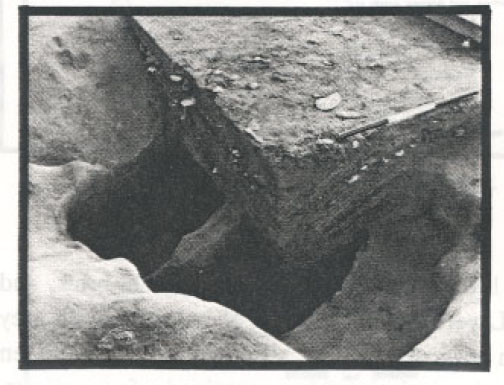 Photo 9. Quarter-section—Trash Pit B.
There were no inclusions or artifacts recovered from the deposit.
Photo 9. Quarter-section—Trash Pit B.
There were no inclusions or artifacts recovered from the deposit.
This clean fill covered Layer 46, which consisted of brown loam mottled with sandy clay. Excavation of Layer 46 revealed that the bottom of the trash pit contained two large holes ca. 4.5' by 2.0', filled with two feet of Layer 46. The holes were parallel, divided by subsoil 0.5' wide at the top and one foot wide at the bottom. The purpose of these holes is as yet unknown, but may have served as underground storage prior to the construction of the cellar. The holes were apparently fill purposefully and rapidly, as few artifacts were found in the fill. Only the portion of the pit above the holes appears to have been filled gradually with household debris.
Trash Pit C
Trash Pit C was a roughly circular feature about 6.0' in diameter located in the western part of the site near a series of trash deposits along the western slot fence. The pit was the largest of these deposits and was located only about 9.0' northwest
of the well. The top layer of the pit was actually made up of several lenses (see Figure 24), none of which extended across the entire feature. The fill in Layer 25 consisted of 1.8' of very dark brown sandy loam with an extremely heavy concentration of oyster shell. Brick and charcoal
61
 Figure 23. Section—Trash Pit B.
62
Figure 23. Section—Trash Pit B.
62
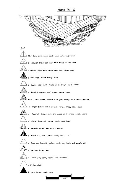 Figure 24. Section—Trash Pit C.
63
inclusions were also noted, but not in anywhere near the concentration of the oyster shell. Over 900 artifacts were recovered from Layer 25. Numerous lenses representing many discreet deposits made up the lower layer (Layer 41) in Trash Pit C. The fill was basically grey sandy loam with patches of purple ash and washed-in lenses of orange clay, some 0.6' deep. Shell, brick and
charcoal were noted inclusions. Layer 41 contained 114 artifacts and around 80 pieces of animal bone.
Figure 24. Section—Trash Pit C.
63
inclusions were also noted, but not in anywhere near the concentration of the oyster shell. Over 900 artifacts were recovered from Layer 25. Numerous lenses representing many discreet deposits made up the lower layer (Layer 41) in Trash Pit C. The fill was basically grey sandy loam with patches of purple ash and washed-in lenses of orange clay, some 0.6' deep. Shell, brick and
charcoal were noted inclusions. Layer 41 contained 114 artifacts and around 80 pieces of animal bone.
Trash Pit D
Trash Pit D was roughly circular, about seven feet in diameter and 1.75' in depth (Figure 25). The top layer, Layer 49, consisted of dark brown sandy loam with a very heavy concentration of oyster shell, very similar to Trash Pit C. About 1.2' in depth, Layer 49 contained about 600 seventeenth-century artifacts. Layer 64 was the second deposit in Trash Pit D, consisting of a 0.15'thick lens of light tan sandy loam, mottled with grey sandy loam containing inclusions of shell, brick, mortar, and charcoal, in addition to a good assortment of seventeenth-century rubbish. Below 64, another lens (Layer 67), about 0.2' deep consisting of grey ash was located. Inclusions of shell, brick, mortar, and charcoal were recovered, in addition to artifacts such as coarseware, aboriginal pottery, case bottle glass, nails, pins, aiglets, coal, and domestic and imported smoking pipe fragments.
The bottom layer in Trash Pit D was Layer 68, a re-deposited subsoil layer about 0.2' deep containing only charcoal inclusions and aboriginal pottery and flakes. This layer may represent soil washed-in between the time the pit was dug and its initial use as a trash receptacle.
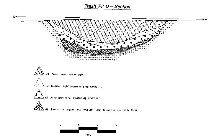 Figure 25. Section—Trash Pit D.
 Trash Pit E
Pit E was an irregularly-shaped pit located about 15' west of Trash Pit D in the northwestern section of the site. On the surface the feature was about 8.5' long, 6.0' wide on the eastern side and 4.0' wide on the western. About 0.7' below the surface, however, the pit became rectangular, approximately 7.0' long and 2.4' wide, very much like a grave feature. The top fill (Layer 87) appeared to have been disturbed somewhat by the growth of a later tree, but consisted of dark brown sandy loam with inclusions of shell and brick (Figure 26). Although it appeared to be a trash pit, relatively few artifacts in comparison with the other trash pits, were recovered from the fill. The bottom surface of 87, and therefore the top surface of Layer 97, was undulating, about 0.7' deep at the deepest point. Layer 97 completely filled the grave-like part of the feature also resting on the bottom of the upper part of the pit. The fill was a fine tan sandy soil containing no inclusions and only five fragments of aboriginal pottery and two sherds of English coarseware. Although the feature appeared to be a human grave shaft, virtually identical to those excavated at contemporary sites, no trace of human remains could be found. Perhaps the intended occupant recovered from his illness or the soil in 350 years completely absorbed the bones. Since most people in that time period were buried without the benefit of clothing, no aiglets, buckles or buttons would have been interred with the body and thus none subsequently survived.
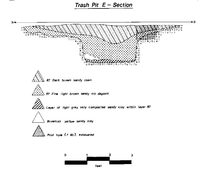 Figure 26. Section—Trash Pit E.
 "The Ditch"
A ditch, approximately 3.0' wide was found in the northwest section of the site, some 5 to 6 feet west of the main north-south slot fence. The feature began about 7 feet northeast of Trash Pit D, and extended 30 feet northward beyond the limit of excavation, toward Settler's Landing Road. In section, the ditch was trapezoidal in shape, that is, wide at the top, with sloping sides and a narrow, flat bottom (Figure 27). The fill was composed of three layers: about 1.4' of dark grey sandy loam, a 0.2' lens of tan sandy silt, and the bottom layer of brownish orange sandy clay about half a foot deep. Sixteen fragments of case bottle glass, a fire-cracked rock, a flake, and some faunal bone were recovered from the first layer in the section excavated. No finds or inclusions were noted in the lower two layers. The function of this ditch is unclear. It may have been constructed as a drainage ditch to remove excess water from that area of the site. The silt and sand in the bottom seems to indicate that the ditch had been left open for some time and was probably not used to support a palisade or other type of fence. Although the few artifacts recovered from the feature did not indicate a fill date, it may have been constructed after the north-south slot fence just to the east. Had the two features been contemporaneous, it is likely they would be parallel to each other, but in reality they are not.
The Slot Fences
Among the more distinctive features discovered at HT55 were the ten slot fence trenches found throughout the site (Figures 28 and 29). The fence remains are similar to those found at Wolstenholme Towne in James City County (I. Noël Hume 1979) and at Nansemond Town in Suffolk (Luccketti n.d.). The fences, which stood about four to five feet high, were constructed by digging a trench 6 to 8 inches wide and a foot or so deep, placing upright planks in the ditch, and securing them by packing dirt around their bases. The planks would be placed so that they touched
 Figure 27. Section—ditch feature.
each other, forming a wall similar to a palisade. This type fencing was used primarily to confine small yard animals in certain areas and prohibit them from entering others, such as kitchen gardens or well surrounds.
Figure 27. Section—ditch feature.
each other, forming a wall similar to a palisade. This type fencing was used primarily to confine small yard animals in certain areas and prohibit them from entering others, such as kitchen gardens or well surrounds.
The western half of the site contained two slot fences, one (Slot Fence A, Features 286 and 69) running north-south approximately 97 feet, beginning near the southern edge of excavation and continuing north, out of the excavated area.
It seemed to serve the function of separating the dwellings and outbuilding from the western third of the site. The trench was about a foot wide and 0.3' deep, consisting of dark grey sandy loam with shell, brick, and charcoal inclusions. Artifacts recovered from the small area excavated included two nails, some bone, and an imported pipe bowl fragment and stem. An east-west slot fence (Feature 69) intersected Feature 286 about 30' north of its southern reach, forming a right angle. This fence slot continued to the west for about 50', ending before the western edge of excavation. It was about a foot wide and 1.2' deep, with visible soil stains indicating the planking, both in plan and profile (see Figure 30). The fill was primarily dark
66
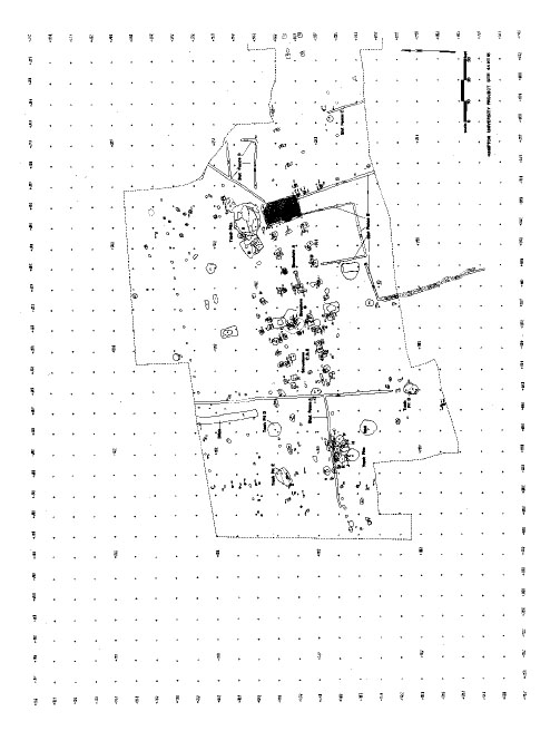 Figure 28. Overall drawing—44HT55, showing location of slot fences.
67
Figure 28. Overall drawing—44HT55, showing location of slot fences.
67
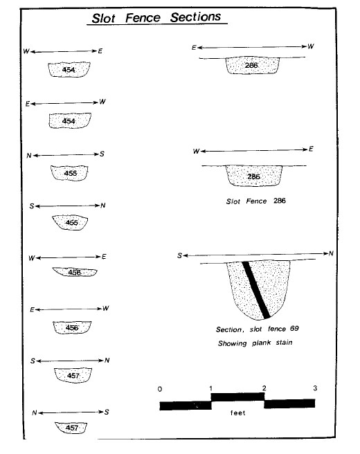 Figure 29. Section drawings—slot fence trenches.
68
brown sandy loam with orange sandy clay redeposited subsoil packed in around the planking. It was apparently constructed or re-dug after the numerous small trash pits in the area were in use, as it intrudes nearly all of them. In addition to the
shell, brick and charcoal inclusions, numerous artifacts were recovered. This debris probably made its way into the slot fill when it was dug through the trash pits.
Figure 29. Section drawings—slot fence trenches.
68
brown sandy loam with orange sandy clay redeposited subsoil packed in around the planking. It was apparently constructed or re-dug after the numerous small trash pits in the area were in use, as it intrudes nearly all of them. In addition to the
shell, brick and charcoal inclusions, numerous artifacts were recovered. This debris probably made its way into the slot fill when it was dug through the trash pits.
Several more slot fences which seem to form two enclosures were located on the south side of Structure A. Features 371 and 455 (Slot Fence B) form a 26' square enclosure attached to the south side of Structure A, beginning at the southwest corner of the cellar, extending 26', making a right angle, running another 26' westward, then making another right angle and running 26' back to the southwest corner post of the structure. There is a one-foot gap in the southeast corner of the enclosure which probably served as an entrance into the enclosed area. Feature 371, the slot extending southward from the cellar, consisted of brown sandy loam mixed with orange sandy clay subsoil and contained two fragments of lead glazed coarseware. It was about 0.8' wide and only 0.2' deep. Feature 455, the west and north extensions of the slot, was also about 0.8' wide and 0.3' deep, consisting of dark brown sandy loam, containing coarseware, slipware, two aiglets, nails, case bottle glass and bone. Both slots were undoubtedly much deeper when they were dug, the site having lost about a foot or more of soil to plowing.
Feature 432, also designated Slot Fence A, was the slot fence extending from the southeast corner of the cellar of Structure A southward about 40' to the edge of excavation. Its actual length is not known. It is flanked on the east by a line of post holes about eight feet apart, which make a right angle at the corner of the cellar and extend another 45' eastward to the eastern edge of the excavated area. Feature 432 consisted of brown loam mottled with orange sandy clay re-deposited subsoil and contained shell, an aboriginal projectile point and a faunal bone. This 0.8'-wide slot was about 0.7' deep, but no plank stains were evident.
Slot Fence C (Feature 112) was located 34 feet east of 432, oriented parallel to it. It began some 20 feet north of the southern edge of excavation. Its southern extent is not known, but it is assumed that it makes a right angle, forming an enclosure by intersecting 432 somewhere in the unexcavated portion of the site. Feature 112 consisted of dark brown sandy loam fill. The feature was not excavated.
Slot Fence D (Features 278, 452, 453, and 454) extended 34' from the northeast corner of the cellar northeastward at about a 45° angle to Structure A, to the edge of excavation. Some 22' along its length, Slot Fence Feature 453 extended towards the east, forming a "Y-shaped" trench. From its intersection with 278, it ran about 20' to the eastern edge of excavation. The actual length and configuration of the two trenches is unknown. Feature 278 consisted of orange sandy clay with dark patches of brown sandy loam but contained no artifacts. Feature 453 consisted of dark brown loam, was about 0.4' deep, containing no finds.
Just south of slot fence trenches 278 and 453 was an "L-shaped" slot feature (Feature 452/ 454), which formed a 12' by 24' enclosure with gaps at the northeast and southwest ends. Feature 452 began about 2' east of 278, running 24' east at which point it made a right angle running 8' to the north (454). Both consisted of dark brown sandy loam about 0.8' wide and 0.4' deep, but contained no artifacts.
The Well
The well for HT55 was located primarily in unit 250S 280E in the southwest quadrant of the site, about 18' south of Slot Fence A and 16' west of Feature 286. It was roughly circular, with a diameter of about 7.4'. Water was encountered at about 8 feet below grade. As is the case with most wells, it had been recognized as a convenient trash receptacle after it lost its usefulness as a water supply or during a clean up project as the site was vacated. Thousands of artifacts, shells, 69 and pieces of animal bone were recovered from the well fill, all dating no later than the third quarter of the seventeenth century. Discussions of the artifacts from the well and its faunal material are provided in Chapters 6C and 7; the following is a physical description of the ten layers of fill recorded during excavation (see Figure 30).
The top layer of the well, Layer 107, was comprised of dark brown sandy loam with orange mottling and some yellow sandy washed-in lenses. The layer was rather flat and 0.7' in depth, contained heavily-compacted oyster shell in addition to brick, mortar, and charcoal inclusions. The second layer, Layer 175, varied in depth from 0.25' to 1.4', was comprised of orange sandy clay with mottling of dark brown sandy loam. Oyster shell, brick, and mortar inclusions were noted. The third layer, Layer 182, was about 0.8' thick, sloped from east to west and was composed of dark brown ashy loam with a very high concentration of brick rubble. Shell, brick, mortar, and charcoal inclusions were present.
The fourth layer, Layer 191, also sloped from east to west, indicating the well was likely filled by debris being thrown in from the east, a logical assumption since the dwellings were to the east of the well. This layer was 2.2' thick, and comprised of light grey sandy loam with brick, mortar, shell, and charcoal inclusions. The fifth layer, Layer 241, was about half a foot thick, consisted of greenish sandy soil, and also sloped from east to west. Inclusions of shell, brick, and charcoal were recorded. The sixth layer, Layer 242, was about 1.7' thick and comprised of a dark sandy loam with a very high concentration of brick rubble, much charcoal and ash as well as some oyster shell. The intact skull of a cow (Photo 10) was found in this layer. It is the oldest known complete cow skull recovered from any archaeological site in this region, and thus is of great scientific interest.
The seventh layer, Layer 275, was about 1.2' thick and consisted of yellowish orange sandy loam with shell and brick inclusions. The eighth layer was comprised of about 0.7' of orange wash or evidence of slumping of the surrounding
 Photo 10. Detail of cow skull in well.
sub-soil. The last cultural layer, Layer 297, was approximately 0.5' thick and consisted of dark grey clay mottled with lumps of compact brown sandy loam. Shell, brick, and charcoal inclusions were noted. Excavators dug two feet below Layer 297 to be sure no further layers existed which would contain any cultural deposits; all that was encountered was two feet of orange coarse sand, gravel and water.
Photo 10. Detail of cow skull in well.
sub-soil. The last cultural layer, Layer 297, was approximately 0.5' thick and consisted of dark grey clay mottled with lumps of compact brown sandy loam. Shell, brick, and charcoal inclusions were noted. Excavators dug two feet below Layer 297 to be sure no further layers existed which would contain any cultural deposits; all that was encountered was two feet of orange coarse sand, gravel and water.
Prehistoric Features
Four features of probable prehistoric origin were identified at HT55. All contained Mockley ware ceramics as found at sites HT36 and HT37, suggesting that they date from the Late Woodland I Period.
Three of the features are relatively small, shallow pits, all bowl-shaped in profile. Feature 155 (S260 E280) was 2.0' in diameter and 0.85' deep. The orange, brown sandy loam fill contained 4 sherds of shell-tempered, cord-marked ceramic and 2 flakes, one each of quartzite and green slate. A slightly larger pit, Feature 203 (S250 E340) was filled with grey-brown sandy loam with flecks of shell. Extending 0.9' in depth and 2.3' in diameter, the feature yielded 19 shell-tempered sherds (17 cord-marked, 2 plain) and a small schist cobble possibly used as an anvil stone. Feature
70
 Figure 30. Section drawing of well.
71
194 (S160 E370) was 2.2' in diameter and 0.4' deep. Eight shell-tempered cord-marked sherds and 6 quartz flakes were recovered from the fill.
Figure 30. Section drawing of well.
71
194 (S160 E370) was 2.2' in diameter and 0.4' deep. Eight shell-tempered cord-marked sherds and 6 quartz flakes were recovered from the fill.
Feature 407 (S150 E380) was a large oval pit, very shallow in depth. The feature measured 4.5' by 3.5' in plan and extended only 0.35' below subsoil level. The bottom was irregular. Fill consisted of light tan-grey sandy loam containing 3 shell-tempered, cord-marked sherds. In light of the very small number of lithic artifacts recovered during the Hampton University excavations, Feature 407 was remarkable in that it also contained 254 quartz flakes (most smaller than 20 sq cm in plan), 6 quartzite flakes, the remnant of a quartzite core, and a fragment of the blade tip to a quartz projectile point.
Chemical Analysis
Although chemical analysis was carried out at HT55, few of the sampled features contained significant amounts of potassium or phosphorus (see Figure 31). Those containing high levels of calcium (Features 77 and 79) both contained oyster shell, probably leading to the high readings.
B. The Structures at HT55
(Figure 33)
Note: The authors are indebted to Cary Carson of Colonial Williamsburg's Department of Historical Research and Fraser Neiman of Yale University for their insights regarding the sequence and construction methods of the structures at 44HT55. Both Cary and Fraser are notedFigure 31. Soil chemistry—44HT55. 72 authorities in the realm of post-in-the-ground construction techniques and the archaeology thereof. Fraser is presently building a classification system for these types of structures. Much of the interpretation comes from personal communication and correspondence with both scholars and from their publications on Tidewater impermanent architecture and on the Clifts Plantation Site in Westmoreland County, Virginia.
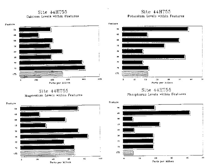
During the course of excavation at HT55 and during the process of sorting what was found, the several earth-fast structures delineated there acquired clever names such as Structure A, Structure B, etc. The letter designations, however, have little to do with the chronology of the site. Structure A, for example, was so named because it was, from the beginning, the most obvious, having a brick-lined cellar and due to the fact its post hole configuration was not obscured by superposition on a previous structure. When first uncovered, the remaining buildings appeared, from the ground surface, to be a confusing mess of post holes, some intruding others which, in turn, intruded still earlier features. It was not until they were mapped, in fact, that the various buildings and their sequences could be untangled.
Structure C appears to have been the first building erected at the site. The paucity of historic artifacts in the post hole fill attests to the fact that little was lying around on the surface which could have subsequently been backfilled with the posts. It was also the largest structure built at HT55, measuring 20' north-south by 40' east-west. Four pairs of posts framed three larger-than-average bays, two measuring 13' and the other 14'. The other four structures at HT55 have bays of 10', except Structure E which sports two 12' bays. Buildings forty feet long generally have four bays rather than three; to illustrate this point, and the uncommonness of Structure C, below is a partial list of ca. 40' earth-fast buildings discovered in Virginia with approximate construction dates and number of bays:
Another variation on the interpretation of the configuration of the post holes of Structure C has been suggested by Cary Carson (C. Carson, personal communication). He suggests that the seemingly errant post holes along the northern side of
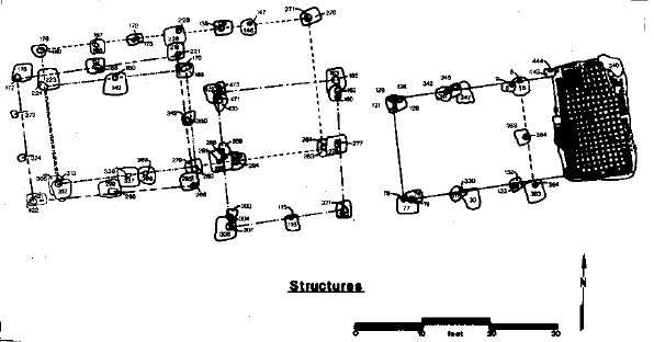 Figure 32. Detail plan of Structures A-E.
73
Figure 32. Detail plan of Structures A-E.
73
| Site Name | Site No. | Date(s) | Size | No. Bays |
|---|---|---|---|---|
| Kingsmill Tenement II | 44JC39 | ca. 1625 | 40'x18' | 4 bays |
| Martins Hundred Site B | 44JC113 | ca. 1625-50 | 44'x22' | 4 bays |
| Mathews Manor | 44NN44 | ca. 1650 | 41'x19' | 5 bays |
| Flowerdew Hundred | 44PG65 | 1619-1630 | 42'x16' | 2 bays |
| Flowerdew Hundred | 44PG65 | 1619-1630 | 41'x24' | 4 bays |
| Clifts Plantation | 44WM33 | ca. 1670 | 41'x18½' | 5 bays |
| John Washington | 44WM204 | 1656 | 40'x21' | 4 bays |
| Jamestown Island Bldg. #71-77 | ----- | ----- | 40'x18' | 5 bays |
| Drummond Site | 44JC43 | ca. 1648 | 36'x18' | 3 bays |
| Littletown Quarter | 44JC39 | 1625-50 | 41'x18' | 4 bays |
| (Kingsmill) |
There is another possible explanation for the three "errant" post holes. They may have been used simply as bracing or shoring on the north side of the structure, the face of the house characteristically receiving the brunt of the harshest weather.
As stated, no signs of a fireplace or hearth were found in the ground, nor could one's placement be conjectured from post positions as was the case in the other structures. Neither was there any evidence of a floor raised on sills. Unfortunately, all such remains supporting or denying such details were destroyed by the plow.
Structure C's relationship with Structures B, D, and E is rather obvious; they could not have been standing at the same time. Its relationship with Structure A, however, is a bit more ambiguous. Structures A and C could have coexisted; however, Fraser Neiman has suggested that this was unlikely for two reasons. First, the large trash pits adjacent to Structure A were probably dug for clay used to daub the walls and chimney (?) in Structure C. The trash pits would probably have been filled before Structure A was erected because of their very close proximity. Secondly, Structure B almost assuredly existed concurrently with Structure A, since they appear to be connected by a short slot fence, and, of course, in order for Structure B to be built, Structure C had to have been torn down.
Just how long Structure C did remain standing is unknown. However, since there appeared to be no evidence of repair to any of the framing posts, it probably survived less than twenty years, possibly even as few as ten (Carson 1981).
Chronologically, the next building or buildings to be erected at HT55 was or were Structures A, B, and/or D. The only certainty regarding the next construction phase is that Structure E was built after Structure D's demise. Judging from the number and kinds of artifacts recovered from the framing post holes, Structures A and B were probably the next built after C. Only one post hole in each of the buildings, original to their construction, contained any artifacts in significant numbers. These were post hole 292 in Structure B 74 and post hole 77 in Structure A. Nearly all of the post holes in both buildings, however, contained some brick or "brick bits." Daub was recovered from post hole 289 and a roofing tile from post hole 163, both in Structure B. The presence of several roofing tiles and "brick-like" material may indicate that one of the earlier structures may have had a tile roof, similar to the 1619-1630 stone foundation house at Flowerdew Hundred (Barka 1976).
In contrast to Structures A and B's lack of artifacts, Structure D contained significant quantities of seventeenth-century material, indicating quite a lot of activity had taken place on the site prior to its being built.
Structure A (Figures 33-35) probably began as a 16' by 20', two-bay structure (each bay ten feet wide), perhaps existing concurrently with Structure B, a similar two-bay 20' by 18' dwelling. As mentioned earlier, the two buildings were connected by a slot fence after their construction. The purpose of the fence may have been to restrict the passage of animals corralled on the south side of the buildings. Both structures exhibited extensive repairs to virtually all of the original framing posts, indicating they were in service for an extend period of time.1 Since the site appears to have been abandoned early in the third quarter of the seventeenth century, the structure may have been erected as early as 1630-35.
Both structures contained a post hole at one gable end of the structure without a corresponding post at the other. This may indicate the presence of fireplaces as noted in Figure 11. There was no other evidence of fireplaces or floors.
Sometime during the course of its use, a passage and a brick cellar were added to the east end of Structure A.2 The cellar was brick-lined and tile-floored, probably 3 to 4 feet in depth at time of construction (Photo 11). The cellar had two entrances, one from the interior and another exterior bulkhead entrance from the north. None of the brick work was held together with the benefit of mortar; instead, clay was used between the bricks as an adhesive. The bricks were small and generally poorly fired. The floor tiles were about 8" square, similar to those found at the Walter Aston Site in Charles City County (Styrna 1984) and at Nansemond Town in Nansemond County (Luccketti 1988), among others. Surprisingly few artifacts were recovered from the excavation of the cellar; in fact, although there is no extant record, nor can it be proven, the cellar seemed to have been excavated and re-filled sometime within the last hundred years. Even though there were no artifacts to support this "feeling," it was shared by the senior author and commented on by visiting archaeologist Ivor Noël Hume.
If this was the case, it is unfortunate, since valuable archaeological information was probably lost forever. The remaining evidence, however, is quite revealing. Structure A appears to have had a typical West Country plan, similar to remains discovered at Clifts (44WM33), the Hallows site (44WM6), and Martin's Hundred Site A (Carson, personal communication). Carson suggests that the lower brick room may have been used as a work area, perhaps above a parlor. He also points out that the cellar appears to be wider than the remainder of the structure, especially on the north side. Since the bulkhead steps to the cellar are on that side, a lean-to may have once extended off the northeast side, protecting the bulkhead and keeping the cellar dry.
Structure D was a small, 15' by 20' house consisting of six framing posts forming two 10' bays, similar to Structures A and B. It, too, had one errant post hole at one gable end, probably indicating a fireplace. There was no evidence to confirm or deny that it was contemporaneous with Structures A and B, but all three probably stood together at some point. There were no repairs to Structure D's framing posts, and indeed the existence of Structure E indicates that D was
75
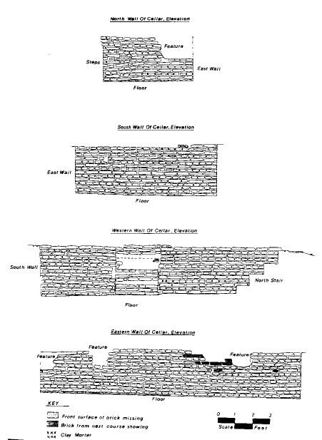 Figure 33. Detail of cellar wall—Structure A.
76
Figure 33. Detail of cellar wall—Structure A.
76
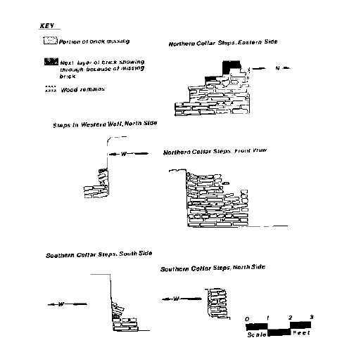 Figure 34. Detail of cellar steps—Structure A.
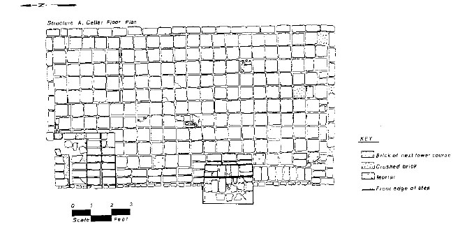 Figure 35. Detail of cellar floor—Structure A.
77
Figure 35. Detail of cellar floor—Structure A.
77
 Photo 11. Detail of brick cellar—Structure A.
removed entirely and replaced, rather than being repaired.
Photo 11. Detail of brick cellar—Structure A.
removed entirely and replaced, rather than being repaired.
Structure E was a bit larger that D, measuring 20' by 24' and consisting of two 12' bays. Its fireplace, however, appears to have been placed at the west gable end as indicated by post holes 373 and 374. The structure was almost certainly the last building erected at the site. Its construction may coincide with the major repairs made to Structures A and B.
The Hampton site has provided several earthfast buildings to the burgeoning archaeological inventory of such structures, which were common but unique to the Chesapeake throughout the seventeenth century. These houses were probably quite typical of the pre-1650 "Virginia house" of the period. The interior walls were not plastered, but likely covered with clapboard, as were the exterior walls and roof. It is unknown whether any of the dwellings had a raised floor on interrupted sills, and any archaeological evidence of buried wall studs would have long-since been plowed away. It is possible that an interrupted sill could have been constructed, providing a wooden floor, but there is no evidence for one. It is not unlikely that any of the structures at HT55 were of block construction (sills resting on wooden posts), as this type of construction was apparently not common until the early eighteenth century (Neiman 1978). The presence of daub in several of the features in and around the buildings suggest that the chimneys and probably some walls were made of mud-covered wood as well. Any evidence of brick hearths would likely have been removed by later plowing in the area.
Careful archaeological technique and experience can explain how they were built, that is, whether they were transverse raised, post-toplate, block, puncheon, etc., but history must interpret why they were so pervasive in this region. The best explanation of the phenomenon can be found in Carson and others, "Impermanent Architecture in the Southern American Colonies" (1981) and in Fraser Neiman, "Domestic Architecture at Cliffs Plantation" (1978). "Impermanent" is indeed an adequate description of the earthfast structures built during this period. Fire, termites, and rot over the past 350 years have destroyed all such buildings in Virginia. The only post building dating to the seventeenth century 78 left in Tidewater is Cedar Grove in Ann Arundell County, Maryland, built in the latter part of the century. This house was preserved only because it was encased in a more substantial structure during the next century (Carson 1981; Neiman 1978). Why such structures which we see today as totally inadequate were constructed pervasively for over a hundred years is an interesting question answered by both Carson and Neiman.
The first and most logical reason for building such structures was the feeling of most of the early colonists that Virginia was simply a place that would provide an opportunity that was unavailable in England—a chance to get rich quickly and return home as soon as possible. With this in mind, the embellishment of one's living space would be costly and time-consuming (Morgan 1975).
"Costly and time-consuming" brings up another very important reason for building a home considered today rude and uncomfortable. The price of building a house in the colonies was thirty percent higher than that of England, and it could take a much longer time (Carson 1981:168). By cutting the cost of building materials, using wood which was plentiful and free, and reducing labor costs by simplifying the construction techniques, one could erect a serviceable shelter which would be expensive but not outrageously so (Neiman 1980). Neiman points out, however, that even those members of the elite such as Pettus, John Washington, and Governor Drummond, who could afford houses of brick, lived instead in earthfast houses. So the economic reasons are perhaps the ones that started the building practice, but not necessarily the ones that perpetuated it. Instead, he suggests that 350 years ago there was a very different view of what was important and what was not.
Although post-in-ground buildings are considered "impermanent" and "rude" by twentieth-century standards, they fulfilled the architectural and housing needs of Virginians in the seventeenth century. None stand today, but then how many apartments, condominiums, and houses that well-serve the needs of today's sophisticated Virginians will survive to the year 2330? As Neiman suggests, ground-to-plate architecture was the answer to a particular problem at a particular time—obviously a very successful answer.
C. Faunal Analysis
(Gregory J. Brown)
Introduction
Animal bone is among the most important material on an archaeological site, providing not only evidence of diet but also some indication of food procurement strategies, marketing and redistribution, seasonality and activity scheduling, environmental conditions, and even trade relations and the effective use of the surrounding resources. The study of archaeological faunal remains—called "zooarchaeology"—investigates these and other topics, using data and techniques from archaeology, anthropology, history, zoology, and animal ethology.
Much of the faunal data gathered in the Chesapeake is summarized in a major work titled "Colonization and Subsistence Change on the 17th Century Chesapeake Frontier," by Henry Miller of the St. Mary's City Commission. Miller's work provides by far the best synthesis of our present state of knowledge about the foodways of early colonists, and it will be referred to often in the discussion below. Other important sources include studies of the food remains from Clifts Plantation (Bowen 1979) and the Maine (Barber 1978), as well as contemporary natural histories (Beverley 1947; Hemor 1957), traveller's accounts (Durand 1934), and studies of seventeenth-century food and foodways (Spencer 1982).
Despite this work, however, there are still significant questions in seventeenth-century Chesapeake zooarchaeology. Many were raised during a 1987 planning conference on Chesapeake foodways (Gaynor et al. 1985), which concluded that a comprehensive and multi-disciplinary research program is needed in order to understand both seventeenth- and eighteenth-century developments in the field. On the archaeological end, this involves continued research on a variety of 79 sites such as those at Hampton University, which will provide a fuller and much richer database to draw upon.
The Hampton University historic site (44HT55) contained some 13,884 individual elements, 3584 identifiable and 10,300 unidentifiable. This is a much larger assemblage than most of those cited in Miller's 1984 work, and indeed is one of the largest bone assemblages from any historic site in the area. The percentage of identifiable elements—26%—is roughly similar to that seen on other local sites, reflecting relatively good preservation conditions and relatively little post- depositional disturbance.
Methods
All animal bone from the Hampton University site was bagged by context and washed. The bone was then sorted into "identifiable" and "unidentifiable" components—identifiable bone being defined as bone which could be classified at least to the taxonomic level of Order. Unidentifiable bone was subdivided into several major taxonomic groupings: fish, reptile or amphibian, bird, bird or small mammal, mammal, small mammal, medium mammal, large mammal, or undetermined. The bones were also subdivided on the basis of major element categories—long bones, flat bones, ribs, vertebrae, crania, mandibles, teeth, spines, and scales. Each particular taxon/element grouping from each particular context was then counted and weighed, receiving a so-called "unique bone number" for use in the computerized database. Once entered, the unidentified bone was put aside.
Each identifiable bone was labelled with its context number and its own unique bone number, in order to facilitate future tracking. These bones were identified by reference to comparative skeletal collections, in most cases using Joanne Bowen Gaynor's collection in the Colonial Williamsburg Department of Archaeological Research. Some of the birds, and all of the reptiles and amphibians, were identified using the collections of the Departments of Birds and Herpetology of the Smithsonian Institution's Museum of Natural History. In all cases, bones were identified on the basis of species-specific morphological characteristics; when such characteristics were virtually identical in several species, the bone was identified to a higher taxonomic level such as genus or family.
Due to the lack of specific morphological indicators in some elements (particularly ribs and, to a lesser extent, vertebrae), many of these elements were grouped together at the level of Family or Order. It should be noted, however, that much of the "Family Phasianidae" material is probably chicken, and much of the "Order Artiodactyla" material is probably pig. When an element was judged to be very likely (but not undoubtedly) associated with a particular taxonomic category, it was labelled "cf." (literally, "compare"). These elements were generally lumped along with the definitely-identifiable elements in most of the analysis below.
Two categories—Artiodactyla I and Artiodactyla II—were used to group certain elements. Loosely based on terminology used by Crader (1984), Artiodactyla I is defined as members of the Order Artiodactyla (even-toed ungulates) which include pig, deer, sheep, and goat. Because pig bones can often be separated from those of the latter three taxa, Artiodactyla II is defined as members of the Order Artiodactyla which include only deer, sheep, and goat. These latter three share many morphological characteristics, but once again deer bone can often be distinguished from that of sheep or goat. The latter two, however, are extremely similar skeletally, so much so that they are most often lumped together as sheep/goats (sometimes called "ovicaprids") by modern analysts.
The identifiable bones were entered into a database created in Ashton-Tate's dBASE III Plus. Recorded information included unique bone number, context number, taxon, element, side, portion that was present, epiphyseal fusion state, relative size, tooth type and wear, weight, and presence or absence of modifications such as burning, weathering, carnivore or rodent chewing, and butchering.
Collection Methods
All soil from the site was screened through one-quarter inch mesh. Portions of selected contexts such as the well were also wet-screened through one-eighth inch mesh. Flotation samples were taken, but little if any identifiable bone was recovered.
It has been argued that screening is extremely important in order to provide a representative sample of all faunal remains (Payne 1972). Many of the sites described by Miller (1984), however, were excavated using the "hand-picking" method; it appears, based on a gross comparison of the percentages of small fragile bones in the various sites, that similar recovery was obtained, and thus these sites can profitably be compared with the Hampton University assemblage (and the other "screened" sites in Miller's sample).
Methods of Analysis and Aggregation
Artifactual and architectural data suggests that the site was occupied for a reasonably short period, circa 1630 to 1660. Aside from a few modern contexts, therefore, all faunal material was aggregated into a single assemblage. The data will be treated as such in the work below, except for certain specific instances where the analysis of seasonal indicators or preservational bias requires that particular features be analyzed independently.
Four different methods of quantification have been used: number of identified specimens (NISP), minimum number of individuals (MNI), usable meat weight, and biomass based on skeletal allometry. Each has its staunch adherents, but it is generally recognized that there are faults in each method. Because they have individual strengths and weaknesses, they will be briefly discussed here.
The NISP method involves simply counting and comparing the numbers of identified elements for each taxon. It is certainly the most basic measure of relative importance, and many analysts have suggested recently that it has been criticized unfairly (Grayson 1984). It is clear, however, that there are problems with this approach. It is skewed toward animals with fragile, easily broken bones; it does not account well for situations where a single animal is disproportionately represented by many bones (as is the case with the cattle found in the Hampton University well); and it obviously must be transformed in some way to indicate that, for instance, the bones of a cow represent far more meat that those of a rabbit.
The MNI method is used to mitigate problems of element interdependence. First proposed for archaeology by paleontologist Theodore White in 1953, it is based on the determination of the smallest number of animals that could have accounted for the faunal remains. In practice this is accomplished by pairing lefts and rights, and counting the largest number of unique elements (all paired bones plus unpaired elements). Following current practice, in this study size variation and morphological differences will be used as factors when pairing elements, thus producing a larger and more accurate MNI count.
Although this seems a conservative and safe approach, the MNI method has been accused of having certain important biases. The counts vary significantly with changes in sample size and differences in the way that the units are aggregated. One approach is to use the entire site as a single assemblage (which is done here), and to determine MNIs for the site as a whole. It is also possible, however, to determine MNIs individually for each feature or group of features, under the assumption that the bones deposited represent different animals than those deposited in other features on the site. The cumulative MNI count using this latter technique will be generally higher, but lacking good archaeological evidence for the function and contemporeity of features it is difficult to determine which count is more accurate.
Nonetheless, MNI counts are the basis of most modern zooarchaeology. They are used in the third major method of quantification, which is simply a transformation technique resulting in a comparison of actual usable meat. The "pounds of usable meat" method involves multiplying the MNI count for each taxon by the average amount 81
| Taxon | N | b | log a | r2 |
|---|---|---|---|---|
| Mammal | 97 | 0.90 | 1.12 | 0.94 |
| Bird | 307 | 0.91 | 1.04 | 0.97 |
| Turtle | 26 | 0.67 | 0.51 | 0.55 |
| Snake | 26 | 1.01 | 1.17 | 0.97 |
| Chondrichthyes | 17 | 0.86 | 1.68 | 0.85 |
| Osteichythyes | 393 | 0.81 | 0.90 | 0.80 |
| Non-Perciformes | 119 | 0.79 | 0.85 | 0.88 |
| Perciformes | 274 | 0.83 | 0.93 | 0.76 |
| Sparidae | 22 | 0.92 | 0.96 | 0.98 |
| Sciaenidae | 99 | 0.74 | 0.81 | 0.73 |
The final method of quantification is based on skeletal allometry: the principle that any two dimensions of an animal's body (for instance, bone weight and total live weight) will vary in a relatively predictable fashion. Used most innovatively by Elizabeth Wing of the Florida State Museum and Elizabeth Reitz of the University of Georgia, this study of "biomass" involves determining the bone weight for a particular taxon and inserting it into a regression equation based on empirical studies at the University of Georgia (for the allometric constants, see Table 6). The principal problems with this approach involve the accuracy of these modern estimates to the allometric relationship of past animals, as well as the significant changes in actual bone weight that can be caused by burning and "post-depositional" decalcification.
Several other attributes of the assemblage were studied as well. The relative proportions of elements were determined for the major taxa, in order to test preservational indicators as well as to determine possible butchery and disposal methods. A feature containing an abundance of hard, dense bones or teeth and very few softer, less dense bones, for instance, should be viewed with caution, since preservational conditions such as soil acidity may have destroyed a significant portion of the original "death assemblage." Such a feature suggests, in fact, that many taxa such as fish and certain birds may no longer be represented at all, and this must be borne in mind for all other related analyses.
Aside from preservational bias, however, element distributions are also useful for indicating butchery and disposal practices. It is often thought, for example, that the remnants of meals should be distinguished by a relative abundance of long bones and vertebrae, while butchery waste dumps should contain mostly non-meaty elements such as phalanges and sesamoids, along with cranial parts. In the seventeenth- and eighteenth-century Chesapeake, however, no such distinction is visible on most sites.
Animal husbandry is another important subject that can be studied. The age structure of the animal populations buried on the site can be determined by evaluating epiphyseal fusion and/or 82 tooth eruption and wear. Epiphyseal fusion distributions have been used in this study, following methods described by Chaplin (1971), and will be discussed shortly.
Tooth eruption is potentially even more discriminating, since the times of eruption have been carefully studied in livestock management. It has been suggested, however, that eruption stages were different in the past, and it is the values for historic populations given by Silver (1969), Payne (1973), and Bull and Payne (1982) that are now generally used. Tooth wear study is becoming increasing popular as well, although the stages are less readily accepted (except Payne's [1973] study of sheep and goats). Nonetheless, an accurate age distribution is only possible with a fairly large sample; none of the taxa from the Hampton University site contained enough teeth to make such a study profitable.
Finally, osteological measurements can be used to help establish the probable size of the animals themselves. The study of so-called "dimensional allometry," however, is not far advanced, and it is generally difficult to determine even the average size (much less the range of variation) for animals in the historic past. Although not used for specific analysis, therefore, the osteological measurements of the Hampton University material were taken in order to contribute to a database being compiled at the University of Georgia, so that this significant avenue of inquiry can be better followed in the future. All measurements taken of this assemblage followed the techniques described by von den Dreisch (1976). The data is on file in the Department of Archaeological Research of the Colonial Williamsburg Foundation.
Taxa Represented in the Assemblage
The Hampton University assemblage contained approximately 14,000 bone elements representing forty-eight species: one crustacean, ten fish, two amphibians, seven reptiles, fourteen birds, and fourteen mammals (see Table 7). Roughly twenty-six percent by total number, and seventy-nine percent by weight, were identifiable to at least the level of Order. A brief description of the species identified will be presented below.
Crustaceans
Twenty-two crab claws were found on the site. The Chesapeake blue crab (Callinectes sapdius) is still widely distributed along the Atlantic coast, living in waters ranging from low- to very high salinity (Lippson and Lippson 1984:127). It was almost certainly taken much as it is today, most likely from near-shore waters. Commercial distribution of crabs, however, was virtually non-existent until better facilities for pickling and salting both fish and shellfish were developed.
Oysters (Crassostrea virginica) were also found in great abundance on the site. Since they are the subject of a separate analysis in this volume, however, they will not be discussed here.
Fish
Fish remains from the site included many of the most common species in the Chesapeake Bay: sturgeon (Acipenser spp.), gaff-topsail catfish (Felichthys felis), striped bass (Morone saxatilis), sheepshead (Archosargus probatocephalus), black drum (Pogonias cromis), red drum (Sciaenops ocellatus), Atlantic croaker (Micropogon undulatus), seatrout (Cynoscion spp.), and requiem shark (Family Carcharhinidae). The most abundant by far were the black drum, the gaff-topsail catfish, and the Atlantic croaker.
The black drum is principally an open-water fish adapted to bottom-feeding on mollusks and crustaceans (Lippson and Lippson 1984; Hildebrand and Schroeder 1928). It is relatively commonly found on seventeenth-century archaeological sites, occurring on eight of the twenty-one sites or phases described by Miller (1984). According to Lippson and Lippson (1984:191), "schools enter the Bay in spring and summer … [where] larger black drums are concentrated in deeper channel waters, often on clam or oyster beds or around wrecks or rock piles." 83
| CRUSTACEANS | |
|---|---|
| Callinectes sapidus (Blue Crab) | |
| FISHES | |
| Acipenser spp. (Sturgeon) | |
| Felichthyes felis (Gaff-Topsail Catfish) | |
| Morone saxatilis (Striped Bass) | |
| Family Sparidae (Porgies) | |
| Archosargus probatocephalus (Sheepshead) | |
| Pogonias cromis (Black Drum) | |
| Sciaenops ocellatus (Red Drum) | |
| Micropogon undulatus (Atlantic Croaker) | |
| Cynoscion spp. (Seatrout) | |
| Carcharhinus spp. (Bull or Milbert's Shark) | |
| AMPHIBIANS | |
| Bufo spp. (Toad) | |
| Rana spp. (Frog) | |
| REPTILES | |
| Sternotherus odoratus (Stinkpot) | |
| Kinosternon subrubrum (Eastern Mud Turtle) | |
| Pseudemys spp. (Painted Turtle or Cooter) | |
| Malaclemys terrapin (Diamondback Terrapin) | |
| Order Squamata (Snakes) | |
| Family Colubridae (Non-Poisonous Snakes) | |
| Elaphe guttata (Corn Snake) | |
| Thamnophis sirtalis (Eastern Garter Snake) | |
| Crotalus horridus (Canebrake Rattlesnake) | |
| BIRDS | |
| Ardea herodias (Great Blue Heron) | |
| Gavia immer (Common Loon) | |
| Phalacrocorax spp. (Cormorant) | |
| Phalacrocorax auritus (Double-Crested Cormorant) | |
| Cygnus columbianus (Whistling Swan) | |
| Anser spp. (Goose) | |
| Anser anser (Domestic Goose) | |
| Branta canadensis (Canada Goose) | |
| Anas platyrhynchos (Domestic Duck/Mallard) | |
| Aythya spp. (Bay Duck) | |
| Gallinago gallinago (Common Snipe) | |
| Family Phasianidae (Quail, Pheasants, and Partridges) | |
| Meleagris gallopavo (Turkey) | |
| Gallus gallus (Chicken) | |
| Colinus virginianus (Bobwhite) | |
| Bonasa umbellus (Ruffed Grouse) | |
| Ectopistes migratorius (Passenger Pigeon) | |
| Turdus migratorius (Robin) | |
| MAMMALS | |
| Didelphis virginiana (Opossum) | |
| Sylvilagus floridanus (Eastern Cottontail) | |
| Order Rodentia (Rodents) | |
| 84 | |
| Sciurus carolinensis (Grey Squirrel) | |
| Sciurus niger (Fox Squirrel) | |
| Castor canadensis (Beaver) | |
| Sigmodon hispidus (Hispid Cotton Rat) | |
| Canis spp. (Dog or Wolf) | |
| Procyon lotor (Raccoon) | |
| Felis domesticus (Cat) | |
| Equus spp. (Horse or Ass) | |
| Order Artiodactyla I (Sheep, Goat, Deer, or Pig) | |
| Order Artiodactyla II (Sheep, Goat, or Deer) | |
| Sus scrofa (Domestic Pig) | |
| Odocoileus virginianus (White-Tailed Deer) | |
| Bos taurus/Equus spp. (Domestic Cow/Horse or Ass) | |
| Bos taurus (Domestic Cow) | |
| Capra hircus (Domestic Goat) | |
| Ovis aries/Capra hircus (Domestic Sheep or Goat) | |
The much smaller Atlantic croaker, a cousin of the black drum, would have been found in shallower waters. According to Lippson and Lippson (1984:111), "small croakers called pin heads, about eight inches long, congregate close to shore in the lower half of the Bay." They could be caught either using a line or in a gill net, and were once extremely plentiful.
The gaff-topsail (or sea) catfish lives primarily in tropical and temperate waters, around river mouths, bays, and harbors (Robins et al. 1986; Hildebrand and Schroeder 1928). It is a scavenging bottom-feeder which can be taken using either lines or nets (Reitz and Scarry 1986). The white catfish or channel catfish (Ictalurus spp.) was identified in seven of Miller's twenty-one sites or phases. Based on the configuration of the frontal bones of the cranium, however, the Hampton University specimens were more likely sea catfish, which were not identified in any of the seventeenth-century sites which Miller describes.
Less common fish remains from the site include sturgeon, sheepshead, striped bass, red drum, and seatrout. The Atlantic sturgeon (Acipenser brevirostris), in particular, was an important food fish for the early colonists; around 1607 John Smith stated that "only of sturgeon we had great store, whereon our men would so greedily surfeit, as it cost many their lives" (Wharton 1957:6). All of these fish, however, were eaten readily, and are listed among the natural wonders described by Robert Beverley in his 1705 work The History and Present State of Virginia (Beverley 1947).
A single shark vertebra was found in one of the features associated with Structure C. It appears to represent either a bull shark (Carcharhinus leucas) or a Milbert's (or blue) shark (Carcharhinus milberti). While the larger bull shark does frequent the mouths of bays and harbors, it is not recorded by Hildebrand and Schroeder (1928); however, they state (1928:48) that the Milbert's shark is more common in the Bay than any other shark except the spiny dogfish.
Amphibians
Amphibian remains from the site came mostly from the well, and most likely were accidental deaths rather than the remains of meals. Almost all were frogs (Rana spp.); some 647 elements, comprising at least twelve individuals, were recovered.
Reptiles
Reptilian remains included both snakes and turtles. Identifiable snakes included the corn snake (Elaphe guttata), the Eastern garter snake (Thamnophis sirtalis), and the canebrake rattlesnake (Crotalus horridus). Like the amphibians, these animals most likely died accidentally on the site and were not used for food.
The most common turtle was the diamondback terrapin (Malaclemys terrapin), which was represented by twenty-six elements from at least two individuals. A virtually-complete terrapin plastron (Photo 12) was found in the well, along with a variety of long bone elements. Small quantities of other turtles were also discovered, including the stinkpot (Sternotherus odoratus), the Eastern mud turtle (Kinosternon subrubrum), and a painted turtle or cooter (Pseudemys spp.).
Birds
The birds recovered on the site included both wild and domestic taxa. Most common were the Anseriformes—ducks and geese—and the Galliformes—such as chickens and turkeys. A small number of wild shore birds, however, were also found, along with a few terrestrial game birds.
The Anseriformes included domestic goose (Anser anser), Canada goose (Branta canadensis), whistling swan (Cygnus columbianus), domestic duck or mallard (Anas platyrhynchos), bay duck (Aythya spp.), and a number of unspecified ducks and geese that may have been either wild or domesticated.
The wild waterfowl were predominantly migratory, arriving in the spring or fall. Their presence thus has direct implications for seasonality
 Photo 12. Turtle plastron.
and scheduling activities. Both the whistling swan and Canada goose, however, spend most of the winter on the Bay (Miller 1984), and therefore were most likely taken in these months. A variety of other wild ducks and geese have been found on other local archaeological sites, and it is likely that a great many were available—particularly during the spring and fall—on nearby ponds, marshes, and shorelines.
Photo 12. Turtle plastron.
and scheduling activities. Both the whistling swan and Canada goose, however, spend most of the winter on the Bay (Miller 1984), and therefore were most likely taken in these months. A variety of other wild ducks and geese have been found on other local archaeological sites, and it is likely that a great many were available—particularly during the spring and fall—on nearby ponds, marshes, and shorelines.
Other birds inhabiting the shoreline were also taken, including common loon (Gavia immer), snipe (Gallinago gallinago), great blue heron (Ardea herodias), and double-crested cormorant (Phalacrocorax auritus).
The Galliformes were overwhelming chicken (Gallus gallus), but also included a few others: turkey (Meleagris gallopavo), bobwhite (Colinus virginianus), and ruffed grouse (Bonasa umbellus). It is likely that all except the chicken were wild species inhabiting nearby woodlands.
Other terrestrial birds included the passenger pigeon (Ectopistes migratorius). Once exceptionally common, in the early 1610s William Strachey (1849:126) noted that: 86
…A kind of wood-pigeon we see in the winter time, and of them such numbers, as I should drawe … the creditt of my relation concerning all the other in question, yf I should expresse what extended flocks, and how manie thousands in one flock, I have seen in one daie, wondering (I must confesse) at their flight, when, like so many thickned clowdes, they (having fed to the northward in the day tyme) retourne againe more sowardly towards night to their roust …
It has been estimated that there were roughly three million pigeons in America around 1600; by the late 1800s, however, they had become extinct (Schorger 1973). Two passenger pigeon bones—a coracoid and a carpometacarpus— were found at the site.
The single passerine bird—a robin (Turdus migratorius)—was almost certainly an accidental death rather than a food source.
Wild Mammals
Wild mammals recovered from the site included opossum (Didelphis virginiana), Eastern cottontail (Sylvilagus floridanus), grey squirrel (Sciurus carolinensis), fox squirrel (Sciurus niger), beaver (Castor canadensis), raccoon (Procyon lotor), cotton rat (Sigmodon hispidus), and white-tailed deer (Odocoileus virginianus).
Most important in terms of diet, by far, was the white-tailed deer, which formed a very significant source of meat for the site's inhabitants. Deer were common in seventeenth-century Virginia, before much of their woodland and brushy scrub habitats were eradicated, and were a source of great wonder to the early colonists. Overhunting, however, apparently caused many local population depletions, and the fluctuations in the availability of these resources probably were a major factor in the colonists' eventual preference for more stable and easily-controlled domestic livestock. Although deer hunting was still very popular by the mid-seventeenth century, relatively few deer bones are present in most eighteenth-century archaeological assemblages.
Deer did offer some significant advantages, however. Not only was the meat utilized, but other products of the animal were exploited as well. Two saw-cut pieces of antler (Photo 13), for example, suggest that the antler tips were being cut for use as tools—possibly as leather-working awls.
The opossum, cottontail rabbit, squirrel, and raccoon inhabited the nearby woodlands and brushy scrub environments, where they existed in some numbers. Beavers and raccoons could be taken around marshes, ponds, and swamps.
Domestic Mammals
The major domestic mammals—cow, pig, and sheep or goat—were by far the most important contributors to the meat diet of the occupants, supplying some 75 percent of the meat as measured using the biomass method (see below). Cow, in particular, was extremely important, supplying both the greatest number of elements and the greatest amount of meat in the assemblage.
The domestic cow (Bos taurus) was brought over from the Old World almost immediately after settlement began. Cattle prospered in the new environment, although it has been suggested that they were not exceptionally well-cared-for. They were mostly allowed to roam free, and by 1633 the predations of carnivores (and local Native Americans) upon cattle herds was one reason for the erection of a six-mile-long palisade across the James-York peninsula.
Of course, the typical seventeenth-century cow was much smaller than the modern breeds, apparently providing only some 400 pounds of usable meat per adult animal (Miller 1984). There is considerable interest in determining the physical characteristics of these early cows, and thus it was remarkable that the well fill contained, at a depth of about six feet, a virtually-complete adult cow skull (Photo 14). The skull, which most resembles a modern Devon in morphology, provides a clear and important picture of the general appearance of these animals in the early colonial period.
87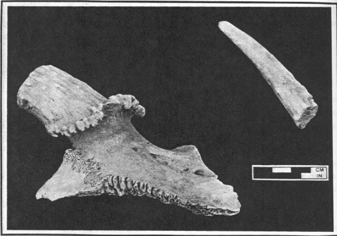 Photo 13. Cut deer antlers.
The domestic pig (Sus scrofa) was the second most important source of meat for the colonists throughout the seventeenth and eighteenth centuries. Pigs were allowed to roam free in the woods, subsisting on what food they could scavenge, and thus required little care. Miller (1984), in fact, has suggested that it was this foraging ability, along with a prolific reproductive rate and fast growth rate, which made them an ideal source of food on the Chesapeake frontier. Probate inventories indicate that, before 1660, almost everyone had one or more pigs; in contrast, in the earlier periods only one-third of inventoried households owned cattle (Miller 1984:297).
Sheep (Ovis aries) or goat (Capra hircus) was not nearly as important as cow or pig. Sheep, being particularly vulnerable to natural predators, were hard to raise successfully in the Tidewater, and they were found in consistently low numbers in the twenty-one sites or phases described by Miller.
 Photo 14. Reconstructed cow skull.88
 Other domestic mammals recovered in relatively low numbers include horse (Equus cabellus) and domestic cat (Felis domesticus). Three bones—a mandible, humerus, and tooth— may represent the remains of either domestic dog (Canis familiaris) or wolf (Canis lupus).
Dietary Contribution
Relative dietary contributions were assessed in two ways—using pounds of usable meat and biomass values (see Table 8). Both methods suggested that cattle were far and away the most significant food resource, accounting for 57.6 percent of the pounds of usable meat and 62.0 percent of the biomass. Pig was second in importance, representing 26.4 percent of the pounds of usable meat and 13.8 percent of the biomass. Next in significance were wild mammals—principally white-tailed deer—which accounted for 7.7 percent of the pounds of usable meat and 3.6 percent of the biomass. Fish were also a major food source, with 4.4 percent of the pounds of usable meat and 2.1 percent of the biomass.
Despite the presence of a variety of wild game and fish, it is clear that the occupants relied quite heavily on domestic livestock. The major domesticates—cow, pig, sheep, goat, and chicken— accounted for 87.2 percent of the pounds of usable meat and 76.1 percent of the biomass, as opposed to 8.4 percent and 3.6 percent, respectively, for wild mammals and birds.
This reliance on domestic livestock, particularly cattle, is mirrored at the other sites described by Miller, where, except for the Maine Site, cow accounted for anywhere between 42.19 and 72.16 percent of the total amount of usable meat. Likewise, pig was consistently the second most important food source, ranging between 11.22 and 36.64 percent. At the Maine Site (the earliest
| NISP | MNI | Usable Meat | Biomass | |||||
|---|---|---|---|---|---|---|---|---|
| No. | % | No. | % | Lbs | % | Kg | % | |
| Dom. Mammals | 2015 | 31.0 | 41 | 31.1 | 6240.0 | 86.7 | 275.10 | 75.2 |
| Pig | 650 | 10.0 | 21 | 15.9 | 1900.0 | 26.4 | 50.51 | 13.8 |
| Cow | 1250 | 19.2 | 13 | 9.8 | 4150.0 | 57.6 | 226.69 | 62.0 |
| Sheep/Goat | 95 | 1.5 | 6 | 4.5 | 190.0 | 2.6 | 14.86 | 4.1 |
| Dom. Birds | 260 | 4.0 | 16 | 12.1 | 38.0 | 0.5 | 3.20 | 0.9 |
| Chicken | 245 | 3.8 | 13 | 9.8 | 20.0 | 0.3 | 2.83 | 0.8 |
| Commensals | 679 | 10.4 | 20 | 15.2 | 0.0 | 0.0 | 0.87 | 0.2 |
| Wild Mammals | 123 | 1.9 | 12 | 9.1 | 552.8 | 7.7 | 13.32 | 3.6 |
| Wild Birds | 48 | 0.7 | 14 | 10.6 | 50.0 | 0.7 | 0.61 | 0.2 |
| Turtles | 32 | 0.5 | 5 | 3.8 | 5.0 | 0.1 | 0.62 | 0.2 |
| Fishes | 1444 | 22.2 | 20 | 15.2 | 314.5 | 4.4 | 7.66 | 2.1 |
| Crustaceans | 22 | 0.3 | 4 | 3.0 | 0.8 | <0.1 | <0.01 | <0.1 |
| Indet Mammals | 1617 | 24.8 | 0 | 0.0 | 0.0 | 0.0 | 63.21 | 17.3 |
| Indet Birds | 268 | 4.1 | 0 | 0.0 | 0.0 | 0.0 | 1.31 | 0.4 |
| Dom. Taxa | 2954 | 45.4 | 77 | 58.3 | 6282.0 | 87.2 | 279.17 | 76.3 |
| Wild Taxa | 1669 | 25.6 | 55 | 41.7 | 919.1 | 12.8 | 22.21 | 6.1 |
| TOTAL | 6508 | 132 | 7201.1 | 365.90 |
| Mean Percentage | |||
|---|---|---|---|
| 1620-1660 | 1660-1700 | 1700-1740 | |
| Cow | 44.26 | 65.39 | 65.62 |
| Pig | 24.65 | 21.94 | 25.46 |
| Sheep/Goat | 0.74 | 1.95 | 3.50 |
| Domestic Fowl | 0.18 | 0.30 | 0.35 |
| Deer | 16.83 | 5.38 | 6.17 |
| Small Mammal | 1.38 | 0.31 | 0.26 |
| Waterfowl | 0.65 | 0.19 | 0.16 |
| Terrestrial Fowl | 0.29 | 0.28 | 0.23 |
| Turtle | 0.25 | 0.32 | 0.23 |
| Fish | 10.66 | 3.92 | 0.90 |
These similarities can be seen most easily in a chart produced by Miller (Table 9), which breaks down the mean percentages of usable meat by three temporal periods: 1620 to 1660, 1660 to 1700, and 1700 to 1740. In the earliest period cow accounted for some 44.26 percent of the total usable meat, followed by pig at 24.65 percent, deer at 16.83 percent, and fish at 10.66 percent. As one can see from a comparison with Table 8, cow was slightly more important at the Hampton University site, with deer and fish correspondingly less important.
Mean percentages for the period 1660 to 1700, however, are much more skewed in favor of domestic mammals, and the Hampton University data thus clearly suggests a temporal placement in the latter part of the period 1620 to 1660.
Livestock Management and Husbandry Patterns
Given the extraordinary contribution of domestic mammals in the diet of the colonists, even during this early period, it is important to understand some of the details of animal husbandry. Most of these patterns, of course, were imported with the colonists; Trow-Smith (1957) and Miller (1984) give useful summaries of livestock management in England during the sixteenth and early seventeenth centuries. Many patterns, however, had to change to accommodate differences in climate, predator pressure, reproductive rate, and animal use between the Old World and the New.
Livestock husbandry can be investigated archaeologically using so-called "kill-off patterns" derived from the bones themselves. As an animal matures, the bone grows outward from various centers of ossification (in long bones, the diaphysis or shaft and two or more epiphyses—at least one on either end). When growth stops, the cartilaginous plates separating the diaphysis and epiphysis themselves ossify, and the epiphysis is said to have "fused." As this stage of skeletal maturity varies among different elements for any individual species, it is possible to separate fused and unfused bones systematically and to construct what amounts to an age distribution for that species (see Figure 36).
These age distributions provide important clues about the ways in which the animals were used. For example, the pig distribution from the Hampton University site indicates that some 70% of the animals were apparently killed in their first
90
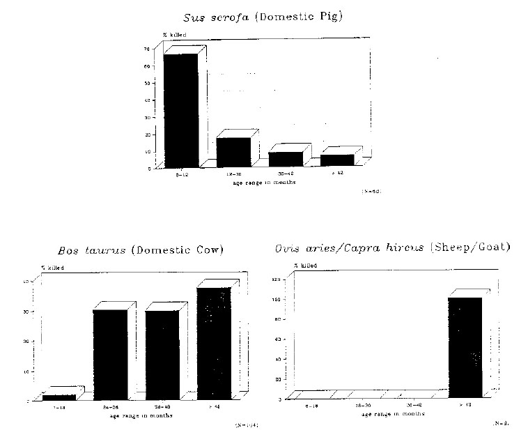 Figure 36. Kill-off patterns—pig, cow, and sheep/goat.
year, with a lesser number killed before 30 months and a few low percentage killed after this time. Pigs obtain their adult weight fairly early, by the age of about twelve months. It appears that most were slaughtered soon after, possibly so that they
did not require further care. Given their freedom to roam in the woods, however, another cause may have something to do with the relative ease with which younger animals could be caught, in contrast to older, presumably wiser, animals.
Figure 36. Kill-off patterns—pig, cow, and sheep/goat.
year, with a lesser number killed before 30 months and a few low percentage killed after this time. Pigs obtain their adult weight fairly early, by the age of about twelve months. It appears that most were slaughtered soon after, possibly so that they
did not require further care. Given their freedom to roam in the woods, however, another cause may have something to do with the relative ease with which younger animals could be caught, in contrast to older, presumably wiser, animals.
The distribution for cow suggests that the great majority were slaughtered after two years of age, with roughly equal percentages killed between two and three years and between three and four years, and a slightly higher percentage killed after four years of age. This would be expected in a so-called "subsistence-based" agricultural economy, where cattle were raised for a variety of purposes. Although a small percentage were slaughtered as veal calves, most were raised to maturity and only slaughtered when they had obtained their optimum weight at about two years of age. As shown by the high percentage of older cattle, however, many were retained as breeders, milk producers, or draft animals.
The distribution for sheep or goat shows that all animals were apparently killed after the age of forty-two months. This suggests that sheep were 91 being raised for their wool, and only killed and eaten after the quality of wool began to decline at six or seven years of age. Relatively few animals were kept, judging by the total number of elements—probably due to the difficulty of protecting them from disease and natural predators.
Site Catchment and the Use of the Environment
In a 1979 review article, Donna Roper defined a site catchment as "that area for which a site (or more properly, the inhabitants of a site) derived its resources" (1979:120). First used in archaeology by Claudio Vita-Finzi and Eric Higgs (1970), it is a useful conceptual tool for explaining resource use and exploitation. Given the lack of a comprehensive environmental and ecological reconstruction for the Hampton University site, however, it will be treated here on a fairly gross level.
Generally speaking, the faunal remains from the site suggest that the occupants were exploiting a variety of local habitats, including woodland, brushy scrub, marshlands, inland swamps, shoreline tidal flats and channels, and even perhaps open Bay waters. Tables 10-13, taken largely from Miller (1984:123-136), shows the normal habitat preferences of the species identified on the site.
It is likely, in fact, that the abundance of small local "micro-environments" in the region was a major reason for its settlement in the first place. It has long been recognized that archaeological sites, both prehistoric and historic, tend to cluster at the junction of environmental zones, where there is access not only to the main resources of those zones, but also to the abundance of wildlife that inhabits the transitions. Bay and stream shorelines are among the most prolific of all transition environments—a fact recognized not only by the earliest Virginia settlers, but also by settlers during later periods.
In these highly-diverse "ecotones," the historic-period settlements were often built atop or near the remains of earlier prehistoric occupations. This is of course the case at the Hampton University site, where the historic occupation was located only some 1000 feet south of a cluster of Middle Woodland-period prehistoric sites, and in fact, it is likely that HT55 itself has probably obliterated most traces of an earlier prehistoric site in the same location.
The Hampton University assemblage does suggest that the enormous species diversity in the area of the site was being exploited. At least forty-two wild taxa were used in some way. Nonetheless, analysis of the data leads inescapably to the conclusion that it was domestic livestock, and not the natural products of the local environment, that was the subsistence base of the occupants. Despite the faunal diversity of the area, the settlers relied heavily on cattle, and to a lesser extent pigs, and almost undoubtedly shaped their own environment accordingly—clearing fields for grazing, protecting them from predators, and foregoing a certain amount of hunting and fishing.
The heavy reliance on domestic livestock—a trend which would become more and more pervasive in the eighteenth century—may have several causes. Miller (1984) suggested three: that livestock was a form of economic security in a largely exchange-based economy; that they provided a means of passing on an inheritance to one's children; and that they provided the settlers with a subsistence system which was very much like the one that they or their parents grew up with in England. In the end it is this last reason which may be most important of all; by raising livestock in a traditional British manner, the occupants of the site were able to subsist without relying solely on a rich, but still probably unfamiliar, local environment—one which in addition was subject to periodic seasonal fluctuations in both quantity and diversity.
Nonetheless, the rearing of domestic livestock did not totally obviate the effect of the environment on the site's occupants. It appears that there were plagues throughout the seventeenth century, among them a major cattle plague in 1672-73 that "killed many thousands of animals in Virginia and Maryland"(Miller 1984:297) . At such times 91
| Tidal Fresh | Low Oligo-Haline | High Meso-Haline | Meso-Haline | Poly-Haline | |
|---|---|---|---|---|---|
| Blue Crab | X | X | X | X | X |
| Sturgeon | --- | X | X | X | X |
| Sea Catfish | X | --- | --- | ||
| Striped Bass | --- | X | X | X | X |
| Sheepshead | X | X | X | ||
| Black Drum | — | X | X | ||
| Red Drum | X | X | |||
| Atlantic Croaker | --- | X | X | X | |
| Seatrout | --- | X | X | ||
| Milbert's Shark | --- | --- | X | --- |
--- = secondary habitat
| Fresh Marshes | Brackish Marshes | Inland Swamps | Forest | |
|---|---|---|---|---|
| Toad | X | X | X | |
| Frog | X | X | X | X |
| Stinkpot | X | X | ||
| Mud Turtle | X | X | X | |
| Painted Turtle | X | X | X | |
| Cooter | X | X | X | |
| Diamondback Terrapin | X | X | X | |
| Corn Snake | X | |||
| Garter Snake | X | X | X | X |
| Canebrake Rattlesnake | X | X |
--- = secondary habitat 93
| Open Bays | Fresh Marshes | Brackish Marshes | Inland Swamps | Forest | |
|---|---|---|---|---|---|
| Common Loon | X | X | |||
| Great Blue Heron | X | X | X | ||
| Double-Crested Cormorant | X | ||||
| Whistling Swan | X | ||||
| Domestic Goose | X | X | |||
| Canada Goose | X | X | --- | ||
| Mallard | X | X | --- | ||
| Bay Duck | X | --- | |||
| Snipe | X | X | |||
| Turkey | X | ||||
| Bobwhite | X | ||||
| Ruffed Grouse | X | ||||
| Passenger Pigeon | X | ||||
| Robin | X | X |
--- = secondary habitat
| Forest | Transitional Zone | Inland Swamps | Coastal Marshes | |
|---|---|---|---|---|
| Opossum | X | X | X | |
| Eastern Cottontail | X | --- | --- | |
| Grey Squirrel | X | --- | ||
| Fox Squirrel | X | X | ||
| Beaver | --- | X | X | |
| Cotton Rat | X | X | ||
| Grey Wolf | X | |||
| Raccoon | X | X | X | X |
| White-Tailed Deer | --- | X | --- | --- |
--- = secondary habitat 94 wild resources would play a much more prominent role. Likewise, since many stock animals were allowed to roam free in the woods and swamps nearby, they were reliant on the botanical resources of these areas for their food. The slash-and-burn method of land clearing, not only for pasture land but more importantly for tobacco fields, not only altered the natural balances of these faunal and floral communities, but actually created a whole new set of habitats with a new set of wildlife. It would be interesting to measure through time the changes in site catchment size, local resource diversity, and environmental equilibriums as the area around Hampton University was settled and developed; such a study, however, will require a much larger and more diversified database than we presently have gathered.
Seasonality and Scheduling
Nonetheless, the presence of migratory waterfowl and other transients in the assemblage suggests that some clues can be discovered regarding seasonality and scheduling. Seasonality refers to the periodic fluctuations in the variety and nature of the resources themselves, as conditioned by migrations, reproduction, and variation in the animal's yearly cycle. Scheduling, on the other hand, is defined by Kent Flannery (1968:227) as "a cultural activity which resolved conflicts between procurement systems"—in other words, a mechanism by which humans were able to effectively make selective use of seasonally-varying resources in a relatively efficient manner.
A brief look at the assemblage indicates clearly that, like most in the Chesapeake, the site was occupied year-round. It is likely, of course, that wild resources such as migratory waterfowl were exploited most heavily at particular times of the year, and that at these times other resources were exploited a little less heavily (a scheduling decision). This is even true in a subsistence economy based on domestic livestock; since meat preservation was difficult, most animals were probably slaughtered in the late fall or early winter when the colder temperatures would serve to keep the meat somewhat fresher.
It appears that this slaughtered livestock was the majority of the diet throughout the winter and early spring, and that there was a shift toward a greater reliance on wild mammals, turtles, and fish in the summer and early fall. Migratory waterfowl were probably taken at their periods of greatest abundance, in the spring and fall (Miller 1984:272273).
This seasonal round can be used to investigate larger questions as well. Miller (1984) was able to define the depositional period of a variety of features using the faunal remains which they contained. Such analyses of course presume that the feature was filled relatively quickly, and that the fill was not redeposited soil from elsewhere in the yard (which could have been originally deposited during another season). Thus a seasonal determination is possible only for features such as the trash pits, and not the well, which was probably filled using nearby sheet refuse and trash deposits that had built up over a period of years.
Several of the trash pits from the Hampton University site were analyzed in this way. Trash Pit A, for example, contained the remains of several fish (striped bass, sheepshead, black drum, Atlantic croaker, and seatrout), as well as turtles including stinkpot and diamondback terrapin. A single bone from a mallard or domestic duck (Anas platyrhynchos) represents the only possible example of migratory waterfowl. In composition this assemblage appears to most resemble Feature 28A from Bennett Farm Phase I, which Miller (1984:439) suggests was deposited in the summer.
Trash Pit B, on the other hand, contained an even wider variety of fish (sturgeon, catfish, striped bass, sheepshead, black drum, Atlantic croaker, and seatrout), along with stinkpot, Eastern mud turtle, and several snakes. Migratory waterfowl include Canada goose and mallard or domestic duck. Pig bones were relatively common (51 out of 502 identified to Class), but only six cow bones were recovered. This relative scarcity of domestic livestock, and presence of migratory waterfowl, turtles, and fish, suggests a spring to summer deposition.
95Other trash pits suggest a fall to winter deposition. Trash Pits C, E, G, and H, for example, include almost all domestic livestock. Although relatively few bones were recovered in some of these features, it appears that they were deposited during a period when few waterfowl or fish were being taken.
Finally, Trash Pit D suggests deposition over a relatively protracted period. A variety of fish were found, along with two types of turtles—suggesting deposition in the spring or summer. However, domestic livestock, particularly cow and pig, were fairly abundant as well, suggesting some deposition in the winter.
Conclusions
The faunal remains of the Hampton University site reveal important information about diet, environmental utilization, and animal husbandry in the period 1620-1660. They do not, however, provide the complete picture regarding food and foodways; additional data from oyster shell analysis, paleobotanical research, and documentary studies must be factored in as well.
The information gathered at the Hampton University site suggests that, as on most contemporary archaeological sites, domestic livestock was by far the most significant food source, accounting for the vast majority of the meat consumed. Significant contributions, however, were made by wild local resources, including deer, small mammals, wild terrestrial game birds, migratory waterfowl, turtles, and a variety of near-shore fishes. The occupants apparently utilized most of the wide range of ecological communities in the area, taking advantage of the diversity of resources that had naturally been presented to them.
D. Oyster Shell Analysis
(Susan Alexandrowicz)
Oysters have been and still are a very important food in Tidewater Virginia. Historically, they were not only plentiful and easy to procure, but also tasty and nutritious. No special tools or skills were required to gather them, and they were available year around if necessary, although more abundant in some seasons of the year than in others.
In recent years archaeologists have begun to examine oyster shells from historic sites in order to attempt to learn not only during which seasons of the year oysters were gathered, but also which environments were harvested and how the oysters were then processed. For example, they have tried to determine whether they were roasted, how they were shucked, and where the beds were located.
A sample of 5678 oyster shells from eleven contexts from HT55 were collected and processed (see Tables 14-17). Of these, only the shells measuring greater than three inches (a total of 2874 shells) were analyzed. Shells smaller than this size exhibit few of the criteria which were used to analyze the oysters, so they were simply counted and eliminated from further analysis. Unfortunately, however, the strategy for collecting oyster shells evolved during the fieldwork, so the quantities and types of shell from any particular context may not be identical to collections made from another context.
Eight of the contexts from which oysters were sampled came from pit features, and the other three contexts were from the well (Feature 107). Briefly, Context 3, Feature 4 (Trash Pit B) was a pit of dark brown loam and shell; Context 18, Feature 19 was a large trash pit of brown sandy loam and ash located just off the northwest corner of the cellar; Context 26, Feature 25 (Trash Pit C) was a very thick layer of shell mixed with brown sandy loam in a refuse pit on the west end of the site property; Context 39, Feature 38 was dark gray loam and shell in the top layer of Trash Pit G; Context 42, Feature 26 consisted of charcoal and purple ash with many washed-in lenses and shell; Context 50, Feature 49 (Trash Pit D) was a dark brown sandy loam pit filled with many artifacts; Context 67, Feature 58, the second layer in Trash Pit H, was dark brown sandy loam and shell; Context 69, Feature 60, the second layer in Trash Pit G, was dark brown 96 sandy loam with ash and shell; and finally Context 182, Feature 191, Context 216, Feature 242, and Context 237, Feature 275 were all well layers.
Analysis
A number of attributes were examined and recorded for the samples. First, it was noted whether a shell was an upper (right) or a lower (left) valve. Uppers are distinguishable by a ridge in the center of the hinge which fits into a corresponding groove in the lower hinge. Uppers are also typically flatter than the more cup-shaped lowers and they also usually have a smoother, whiter surface which has been less pockmarked by other marine organisms.
Only valves which had a complete hinge were examined. First it was noted whether the valve itself was complete. If a valve was complete its height-length ratio (HLR) was generally calculated to determine the environment in which the oyster grew, since an oyster's shape is influenced by its environment. Oysters have been categorized into four types determined by their HLR and other physical characteristics (Kent n.d.:30).
As described by Brett Kent, an oyster which grows on a firm sandy substrate will develop a more or less round profile with a HLR of less than 1.3, the height being measured from the hinge down and the length being measured perpendicular to the height at the widest point across (Figure 37). This type of shell is referred to as a "sand oyster." Sand oysters usually grow individually, unattached to other oysters. "Channel oysters" have a HLR of greater than 2.0, which means that they are very long and narrow. They are long because they grow in deep water on a muddy bottom and so they have to reach up through the mud to get clear water. Another type of oyster which has a HLR of greater than 2.0 is a "reef oyster." It is easy to distinguish from a channel oyster because it grows in clusters instead of individually and it is proportionally much smaller than the large channel oysters. The last type of oysters is the type which was most commonly
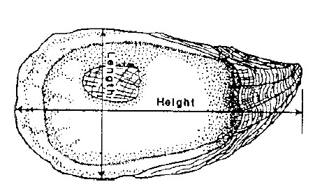 Figure 37. Oyster shell anatomy.
found at HT55. This is the "bed oyster," which has a HLR of between 1.3 and 2.0; it grows on a mixture of sand and mud and it may or may not be clustered to other oysters.
Figure 37. Oyster shell anatomy.
found at HT55. This is the "bed oyster," which has a HLR of between 1.3 and 2.0; it grows on a mixture of sand and mud and it may or may not be clustered to other oysters.
Other attributes were examined as well. Clustering was noted by the presence or absence of other oyster valves or attachment scars on the lower valves for over half their length (Kent n.d.:33). Ribbing and coloring was also examined. These two characteristics develop on valves as a result of how much sunlight an oyster receives. Therefore, sand oysters, which typically develop in intertidal areas, are much more likely to exhibit deep purple coloring on their exterior surface and strong radial ribs which originate at the shell's hinge than are channel oysters, which are found in deeper water (Kent n.d.:30). This ribbing and coloring also is more apparent on lower valves than on the uppers, which are typically smoother.
Oysters can tolerate a wide range of salinity so, just as there are four general types of environment in which an oyster grows, oysters have also been categorized into four regimes based on the relative salinity of the water in which they grew. Basically, according to Kent, these are indicated by the presence or absence of boreholes produced by small (Cliona trutti-type) sponges and large (Cliona celata) sponges, both of which attack the oyster valves. If there are no boreholes in the shell produced by these sponges the water in which the oyster lived was not very saline. This is because, in low-salinity environments, the sponges could not live; even the oysters would 97 find this a particularly stressful environment (Doms and Custer 1983:8), since the variety of plant and animal life in areas of low salinity is less than in adjacent areas of higher salinity (Galtsoff, 1964:398). These low-salinity zones are defined as Salinity Regime I, where the water would have a salinity of less than 10 parts per thousand (ppt) for about half the year, and seldom becomes greater than 20 ppt. If the oyster valves exhibit boreholes from only the smaller sponges, they probably came from Salinity Regime II, where the salinity would be less than 10 ppt approximately one-quarter of the year, less than 15 ppt half of the year, and greater than 20 ppt at some times. Oysters from Salinity Regime III will show boreholes mostly from the small sponges, but will also have some large boreholes. They would have been found in water which had salinity less than 15 ppt occasionally and greater than 20 ppt for one-quarter to one-half of the year. Finally, oysters which grew in very saline water, where the salinity seldom fell below 15 ppt and usually was above 20 ppt, are defined as coming from Salinity Regime IV (Kent n.d.:41).
The presence or absence of other boreholes caused by polydora worms and boring clams was also recorded. Polydora worms, which live in subtidal mud, enter the oyster at the margin between the two valves and leave distinctive double holes around the edge of the oyster. Boring clams, which are found in water with low salinity, leave a hole which is relatively small at its mouth but which opens up to a large cavity within the shell. However, unless there is some erosion of the oyster shell which makes this cavity visible, it tends to be rather hard to determine whether a hole was caused by a boring clam or by a C. celata sponge.
It was also noted whether or not there were any barnacles or net-like bryozoan sponges attached to the oysters, although it is unclear as to whether these are very useful as indicators of environment or salinity.
Results
From this data several patterns emerged (Figure 38). First, 57% of the shells were classified as bed oysters, which are found in a mixture of sand and mud. The fact that 86% of the sample had polydora worm holes also suggests that the shells grew in a muddy subtidal environment. Less than 20% of the shells exhibited moderate to heavy ribbing, and less than 5% exhibited moderate to heavy coloring which also indicates a subtidal environment. Only 12% of the sample were classified as sand oysters, and less than 6% were classified as channel oysters. Thus, most of the oysters did not come from either intertidal zones right along the shore or from very deep waters. Over 70% of the sample exhibited either no or only small cliona holes, indicating water of low salinity. However, boring clams, which are found in water
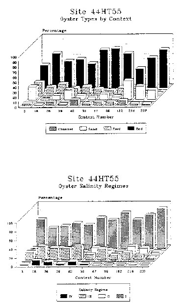 Figure 38. Oyster types and salinity regimes.
98
of low salinity, were definitely noted on only 4% of the sample, although, as was noted, boring clam holes were difficult to identify.
Figure 38. Oyster types and salinity regimes.
98
of low salinity, were definitely noted on only 4% of the sample, although, as was noted, boring clam holes were difficult to identify.
Site HT55 is located between two small creeks or inlets off the Hampton River, which would provide the best conditions for the growth and development of an oyster population (Goode 1887:731; Galtsoff 1964:400). Kendall and Haven's 1982 report on oyster leases along the Hampton River supports basically what the oysters themselves indicated—that, although the main channel of the river varies in depth from approximately nine to fourteen feet, most of the bottom is shallower than five feet. Hence, historically, river oysters must have been gathered in fairly shallow waters.
Kendall and Haven also stated that "the bottom was mud except for some sand near the shore." This should come as no surprise, since most of the oysters found at HT55 were bed oysters, which grow in a mixture of sand and mud. It is interesting to note that of the four oyster leases which were examined in 1982 by Kendall and Haven, two of which are on the same side of the river as HT55 and two of which are on the opposite shore, the one which has the greatest density of oysters per acre (67%) is the one located adjacent to the site.
Although it may be tempting to project backward in time and say that this may have also been the case when the site was occupied, there are a number of dynamic factors which influence the growth and development of an oyster community. Factors such as the character of the bottom, water movements, salinity and temperature of the water, and food supplies all affect the oysters, while sedimentation, pollution, competition, disease and predation will all work against the population (Galtsoff 1964:398-399). In addition, humans, while essentially predators, may also aid oyster beds through seeding to extend their natural environment.
Historical Research
From historical research it seems that oysters were extremely plentiful in Tidewater Virginia. Records from as early as 1607 comment on how the "oysters lay on the ground as thick as stones" (Wharton 1957:5). In fact, during the seventeenth century, there are numerous accounts of settlers and "Indians" surviving on little more than oysters. Apparently oysters were generally easy to obtain even without a boat or canoe, and oysters in the lower James River could even be picked over by hand at low tide (Wharton 1957:26-27). With a boat even more oysters could be gathered with ease, as it was recorded in 1687 that "almost every Saturday my host…had only to send one of his servants in one of the small boats and two hours after ebb tide he brought it back full. These boats…can hold as many as fourteen people and twenty-five hundredweight of merchandise" (Wharton 1957:35).
It was also recorded that oysters were usually caught on Saturday at ebb tide with tongs (Wharton 1957:37-38). The practice of tonging for oysters goes back to the Native Americans, who taught the colonists in Tidewater Virginia how to use tongs not unlike those still in use today (Jackson 1988:66; see Figure 39). This was probably a method which was in use near 44HT55 to gather oysters. By 1701 travellers to the area still were amazed at the incredible abundance of oysters and told of banks of oysters so large that ships must avoid them (Pearson 1942:218; Jackson 1988:63). However, there was little organized industry dealing with oysters until the nineteenth century (Wharton 1957:41) which made unlimited opportunities for exploitation during the time site HT55 was occupied.
Oysters played an important part in the diet of Virginians and are mentioned again and again in the historical literature. Generally, oysters were consumed during the fall and winter months and were avoided during the summer (or, more colloquially, in any month without an "R" in its name because it was considered to be unhealthy to eat them then Pearson 1942:217; Jackson 1988:62) and they were said to cause fevers (Wharton 1957: 38). However, historic references were found which refer to eating oysters in every month except May, April and August. It seems that in the early seventeenth century oysters were eaten in 99 the summer just to keep from starving, and that by the late eighteenth century some people came to disregard the widespread superstition about not eating oysters in the warm months.
Actually, there are valid reasons for not consuming oysters during this period of the year, because the oysters are spawning or have just spawned and thus are played out and less tasty (Jackson 1988:62). Oysters are at their best as energy-producing food between August and November because of the glycogen which they have stored during the summer (Russell 1923:9). In addition, the oyster responds to the salinity of the water; low salinity makes the oyster swell up by absorption of water, and the opposite effect occurs when the salinity increases, generally from June or July until October, apparently as a result of altered osmotic pressure. The percentage of proteins in oysters is highest in the spring and summer and lowest during the rest of the year, while the percentage of carbohydrates varies in an inverse manner (Claassen 1986:34). The "fattening" of oysters in the autumn is as a result of the accumulation of these carbohydrates (Russell 1923:4).
Oysters were, and still are, prepared in a wide variety of ways in Tidewater Virginia. Historically, oysters were smoked and dried, served raw, stewed caked in fritters, made into dressing, fried, pickled, fricasseed, scalloped, curried, deviled, broiled and brochetted, in salads and soups and so on (Wharton 1957:46; Jackson 1988:68). They were also roasted, and oyster roasts have been a Virginia institution which was inherited from the Native Americans. Four percent of the oysters sampled at 44HT55 did show signs of being roasted, but it is unknown how the other oysters were served. The contexts which contained the most roasted oysters were Context 39, with a total of seventy-eight oyster valves (38% of the shells from that feature); Context 3, with a total of seventeen valves (7% of that feature); and Context 237, with fifteen shells (13% of that layer). By contrast, Context 26 contained thirty-five roasted oysters, only 2% of the 1708 valves which were analyzed from that feature.
 Figure 39. Oyster tongs.
Conclusions
The sample of oyster valves from HT55 seems to comprise a predictably homogeneous collection as analyzed so far. The majority of shells from all eleven contexts were categorized as bed oysters, which are found in a mixture of sand and mud. Over 86% of the total number of shells analyzed contained polydora worm holes; since these worms live in mud they indicate a muddy environment for the oysters. In every analyzed context, the majority of the shells contained no cliona holes, which indicates that they grew in water of relatively low salinity. There is also consistency in the amount of ribbing and coloring; most have little or none, which means the oysters were found in deep enough water so as not to receive much sunlight. It would be interesting to conduct seasonality studies on the shells to observe what other patterns, if any, emerge. Unfortunately, time and 100 fiscal constraints precluded this exhaustive an analysis.
This study of oyster shells from HT55 is part of a continuing attempt by Colonial Williamsburg's Department of Archaeological Research to analyze oyster shells from historic sites; two previous studies, yet unpublished, have been conducted on shells from the Peyton Randolph and Shields Tavern properties within the Historic Area. As we realize the potential of what it is oysters can tell us about how, from where and when they were gathered originally, it is hoped that with more refined collection strategies further research we can glean even more information from shells collected from future excavations.
E. Paleobotanical Report
(Eric E. Voigt)
Methods
All 114 paleobotanical samples were scanned for carbonized seed, wood, cultigen and plant remains. An American Optical Microstar Stereoscope with a magnification range of 7-45X was used in the identification of all carbonized plant remains. Identification of paleoethnobotanical material was made through comparison of archaeological material to known modern material from the University of Missouri-Columbia/American Archaeology Division Paleoethnobotany
| Context No. | 3 | 18 | 26 | 39 | 42 | 50 | 67 | 69 | 182 | 216 | 237 |
|---|---|---|---|---|---|---|---|---|---|---|---|
| Uppers | 34.0 | 19.7 | 39.5 | 35.3 | 25.7 | 28.7 | 47.1 | 42.6 | 30.0 | 29.1 | 35.7 |
| Lowers | 65.6 | 80.1 | 60.5 | 63.7 | 74.3 | 71.3 | 52.9 | 56.8 | 70.0 | 71.0 | 63.5 |
| Complete | 100.0 | 83.1 | 80.0 | 51.0 | 65.7 | 65.3 | 100.0 | 74.1 | 100.0 | 100.0 | 87.0 |
| Ribbing | |||||||||||
| None | 56.8 | 38.0 | 51.1 | 44.6 | 45.7 | 48.5 | 65.7 | 49.4 | 52.0 | 48.0 | 36.5 |
| Slight | 34.0 | 45.1 | 31.0 | 29.4 | 20.0 | 36.6 | 25.7 | 24.7 | 36.0 | 38.5 | 32.2 |
| Moderate | 9.1 | 15.5 | 13.5 | 24.0 | 34.3 | 14.9 | 8.6 | 22.2 | 12.0 | 14.0 | 26.1 |
| Heavy | 0.0 | 1.4 | 5.0 | 2.0 | 0.0 | 0.0 | 0.0 | 3.7 | 0.0 | 0.0 | 5.2 |
| Color | |||||||||||
| None | 86.3 | 57.7 | 65.7 | 72.1 | 71.4 | 81.2 | 87.1 | 81.5 | 76.0 | 85.5 | 65.2 |
| Slight | 12.4 | 31.0 | 28.4 | 24.5 | 28.6 | 18.8 | 11.4 | 17.3 | 18.0 | 12.8 | 32.2 |
| Moderate | 1.2 | 8.5 | 5.4 | 2.5 | 0.0 | 0.0 | 1.4 | 1.2 | 6.0 | 1.7 | 1.7 |
| Heavy | 0.0 | 2.8 | 0.4 | 1.0 | 0.0 | 0.0 | 0.0 | 0.0 | 0.0 | 0.0 | 0.9 |
| Clustering | 52.3 | 46.5 | 26.5 | 26.5 | 48.6 | 30.7 | 25.7 | 35.2 | 30.0 | 31.6 | 28.7 |
| Cliona | |||||||||||
| None | 66.8 | 47.9 | 51.5 | 57.8 | 54.3 | 70.3 | 65.7 | 82.1 | 66.0 | 77.0 | 91.3 |
| Small | 13.7 | 9.9 | 14.1 | 13.2 | 5.7 | 14.9 | 10.0 | 6.8 | 18.0 | 13.7 | 5.2 |
| Sm/Lg | 17.8 | 31.0 | 26.5 | 25.5 | 31.4 | 11.9 | 24.3 | 10.5 | 16.0 | 8.5 | 3.5 |
| Large | 1.7 | 11.3 | 7.9 | 3.4 | 8.6 | 3.0 | 0.0 | 0.6 | 0.0 | 0.9 | 0.0 |
| Boring Clam | 1.7 | 5.6 | 5.1 | 5.4 | 2.9 | 2.0 | 1.4 | 3.7 | 0.0 | 0.9 | 1.7 |
| Polydora | 92.5 | 93.0 | 90.0 | 81.4 | 94.3 | 98.0 | 98.6 | 88.3 | 100.0 | 96.6 | 87.0 |
| Barnacles | 24.1 | 15.5 | 9.6 | 6.9 | 2.9 | 5.9 | 4.3 | 4.3 | 12.0 | 6.0 | 11.3 |
| Bry. Sponge | 36.5 | 84.5 | 8.8 | 5.9 | 0.0 | 5.0 | 11.4 | 4.3 | 32.0 | 21.0 | 2.0 |
| Type | |||||||||||
| Sand | 26.1 | 0.0 | 8.8 | 20.1 | 8.6 | 5.0 | 11.4 | 5.6 | 38.0 | 27.0 | 19.1 |
| Bed | 45.6 | 69.0 | 53.6 | 57.3 | 48.6 | 76.2 | 78.6 | 68.5 | 38.0 | 59.8 | 76.5 |
| Reef | 23.7 | 14.1 | 20.2 | 11.6 | 14.3 | 9.9 | 7.1 | 11.7 | 6.0 | 1.7 | 0.0 |
| Channel | 4.1 | 1.4 | 7.0 | 2.0 | 11.4 | 3.0 | 7.1 | 6.8 | 10.0 | 2.6 | 1.7 |
| Context No. | 3 | 18 | 26 | 39 | 42 | 50 | 67 | 69 | 182 | 216 | 237 |
|---|---|---|---|---|---|---|---|---|---|---|---|
| Uppers | 82 | 14 | 675 | 72 | 9 | 29 | 33 | 69 | 15 | 34 | 41 |
| Lowers | 158 | 57 | 1033 | 130 | 26 | 72 | 37 | 92 | 35 | 83 | 73 |
| Complete | 241 | 59 | 1361 | 104 | 23 | 66 | 70 | 120 | 50 | 117 | 100 |
| Ribbing | |||||||||||
| None | 137 | 27 | 872 | 91 | 16 | 49 | 46 | 80 | 26 | 56 | 42 |
| Slight | 82 | 32 | 527 | 60 | 7 | 37 | 18 | 40 | 18 | 45 | 37 |
| Moderate | 22 | 11 | 231 | 49 | 12 | 15 | 6 | 36 | 6 | 16 | 30 |
| Heavy | 0 | 1 | 78 | 4 | 0 | 0 | 0 | 6 | 0 | 0 | 6 |
| Color | |||||||||||
| None | 208 | 41 | 1123 | 147 | 25 | 82 | 61 | 132 | 38 | 100 | 75 |
| Slight | 30 | 22 | 485 | 50 | 10 | 19 | 8 | 28 | 9 | 15 | 37 |
| Moderate | 3 | 6 | 93 | 5 | 0 | 0 | 1 | 2 | 3 | 2 | 2 |
| Heavy | 0 | 2 | 7 | 2 | 0 | 0 | 0 | 0 | 0 | 0 | 1 |
| Clustering | 126 | 33 | 453 | 54 | 17 | 31 | 18 | 57 | 15 | 37 | 33 |
| Cliona | |||||||||||
| None | 161 | 34 | 880 | 118 | 19 | 71 | 46 | 133 | 33 | 90 | 105 |
| Small | 33 | 7 | 241 | 27 | 2 | 15 | 7 | 11 | 9 | 16 | 6 |
| Sm/Lg | 43 | 22 | 452 | 52 | 11 | 12 | 17 | 17 | 8 | 10 | 4 |
| Large | 4 | 8 | 135 | 7 | 3 | 3 | 0 | 1 | 0 | 1 | 0 |
| Boring Clam | 4 | 4 | 87 | 11 | 1 | 2 | 1 | 6 | 0 | 1 | 2 |
| Polydora | 223 | 66 | 1533 | 166 | 33 | 99 | 69 | 143 | 50 | 113 | 100 |
| Barnacles | 58 | 11 | 164 | 14 | 1 | 6 | 3 | 7 | 6 | 7 | 13 |
| Bry. Sponge | 88 | 11 | 150 | 12 | 0 | 5 | 8 | 7 | 16 | 24 | 23 |
| Type | |||||||||||
| Sand | 63 | 0 | 151 | 41 | 3 | 5 | 3 | 9 | 19 | 32 | 22 |
| Bed | 110 | 49 | 916 | 117 | 17 | 77 | 55 | 111 | 19 | 70 | 88 |
| Reef | 57 | 10 | 345 | 23 | 5 | 10 | 5 | 19 | 3 | 2 | 0 |
| Channel | 10 | 1 | 120 | 4 | 4 | 3 | 5 | 11 | 5 | 3 | 2 |
| No. | % | |
|---|---|---|
| Uppers | 1073 | 37.3 |
| Lowers | 1796 | 62.5 |
| Complete | 2311 | 80.4 |
| Ribbing | ||
| None | 1442 | 50.2 |
| Slight | 903 | 31.4 |
| Moderate | 434 | 15.1 |
| Heavy | 95 | 3.3 |
| Color | ||
| None | 2032 | 70.7 |
| Slight | 713 | 24.8 |
| Moderate | 117 | 4.1 |
| Heavy | 12 | 0.4 |
| Clustered | 874 | 30.4 |
| Cliona | ||
| None | 1690 | 58.8 |
| Small | 374 | 13.0 |
| Small/Large | 648 | 22.5 |
| Large | 162 | 5.6 |
| Boring Clam | 119 | 4.1 |
| Polydora | 2486 | 86.4 |
| Barnacles | 290 | 10.1 |
| Bryozoan Sponges | 344 | 12.0 |
| Type | ||
| Sand | 348 | 12.1 |
| Bed | 1629 | 56.9 |
| Reef | 479 | 16.7 |
| Channel | 168 | 5.8 |
| Context No. | Greater than 3" | Less than 3" | Total |
|---|---|---|---|
| 3 | 241 | 323 | 564 |
| 18 | 71 | 110 | 181 |
| 26 | 1708 | 1482 | 3190 |
| 39 | 204 | 423 | 627 |
| 42 | 35 | 11 | 46 |
| 50 | 101 | 69 | 170 |
| 67 | 70 | 162 | 170 |
| 69 | 162 | 253 | 415 |
| 182 | 50 | 48 | 98 |
| 216 | 117 | 38 | 155 |
| 237 | 115 | 60 | 175 |
In general, identification of seeds is accomplished by comparing morphological characteristics of the archaeological sample to those of known, modern taxa. Species differences are not always apparent and critical diagnostic characters (e.g., awns, outer seed coat, and color) often are lost in carbonization. Wood charcoal is identified by examination of the internal anatomy of a specimen and the use of a key developed for carbonized-wood identification. The arrangement of vessel elements, rays, and parenchyma tissue are used in the identification of archaeological specimens.
The Paleoethnobotanical Record
Plant remains from archaeological sites, whether from middens, hearths or features, represent only a fraction of the possible ranges of plants used by a particular human group. It is important to remember that the paleoethnobotanical record, i.e., plant remains and their depositional contexts at archaeological sites, is a product of the differential occurrence of—and the interaction among— various environmental and behavioral site-formation processes (Voigt 1989). Some of these formational processes include differential preservation among plant taxa in their carbonized and uncarbonized states, chances of the remains entering the archaeological record through intentional discard or accidental carbonization, and pedological factors (Asch and Asch 1981; Johannessen 1984; Lopinot 1988; Wagner 1989).
Assumptions about the relative economic importance of plant taxa to human groups are based on: (a) the frequency of co-occurrence of the same taxa at different sites, (b) the relative abundance of different plant taxa at a site (i.e., their ubiquity), (c) spatial and temporal patterning of the paleoethnobotanical data, (d) ethnohistorical, historical, and ethnographic data, and (e) taxon-specific indicators of cultivation or domestication (Voigt 1989). However, such things as "the number of seeds recovered" can serve neither as an adequate nor as an accurate measure of the relative importance of a taxon in the diet of a particular human group.
Taxa Identified—Carbonized Seeds
Due to the nature of the pedological environment at the sites, as well s recovery and processing techniques, many of the seeds were badly eroded. Thus, many identifications are made only to the family or genus level.
Family Chenopodiaceae (Goosefoot)
The Goosefoot family includes wild taxa as well as many field crops and cultivated varieties (Wilson 1981). The seed identified from Trash Pit G appears to be that of a Chenopodium spp. A native wild taxon (C. berlandieri) and its native domesticate (C. berlandieri spp. jonesianum) have been recovered in prehistoric archaeological contexts throughout the Eastern Woodlands (Smith 1984). It also has been suggested that early Euro-American settlers encountered Native American groups that were cultivating this crop.
Family Convolvulaceae (Morning Glories)
The Morning Glory family includes several taxa that were used as food, medicines, and hallucinogens by native North American groups (Dobkin de Rios 1984; Gilmore 1977). Numerous genera and species are invasive in modern agricultural fields (Anonymous 1973). The specimen from the well at 44HT55 could be identified to neither genus nor species. It is possible that it was collected accidently when field crops were harvested.
Family Cyperaceae (Sedges)
The Sedge family includes many taxa that inhabit inland and coastal wet or moist soils (Gleason and Cronquit 1963). Many taxa were collected 104 historically for food and material (Gilmore 1977; Steyermark 1963). It is impossible to say whether the seeds recovered at HT37 and HT55 represent food remains or some other economic use of plant material.
Galium spp. (Bedstraw)
Bedstraw is a common herbaceous plant that flowers in the spring and grows in moist low woodlands and agricultural fields. It was valued historically for its fragrance (Gilmore 1977); it was also used in making beverages (Steyermark 1963:1394) and for stuffing mattresses (Steyermark 1963:1394).
Nyssa sylvatica(Black Gum)
Black gum thrives in mesic habitats, usually growing in moist woods or near swamps. Seeds of this species were also identified in samples from a prehistoric site in southeastern Missouri. However, there is no recorded use of the fruits of this plant for either food or medicine. The wood has been used in the making of furniture (Settergren and McDermott 1977).
Prunus persica(Peach)
Peaches were introduced into Florida by the sixteenth century A.D., grown at Spanish missions throughout the Southeast by the seventeenth century A.D., and were in Virginia in the mid-seventeenth century A.D. (Blake 1986; Mouer 1987a).
Strophostylesspp. (Wild Bean)
Wild bean may have been collected by prehistoric groups, but certain species also inhabit cultivated fields and the disturbed areas around fields where they may have been accidently harvested. The cotyledons identified as wild bean are significantly smaller than those of domesticated bean (e.g., Phaseolous spp.).
Zea mays(Maize)
Maize remains from sites consist of cupules, rachis segments, kernel fragments, and a single cob fragment (Figure 40). There is little doubt that maize extends far back into prehistory as a domesticate (Ford 1983; Galinate 1985). Galinet (1985:277) believes the introduction of maize in the Eastern Woodlands from the Southwest was delayed until "… preadapted, day-neutral varieties of the eight-row race … became available." However, Berry's (1985:304) reassessment of the dates for maize in the Southwest leads him to conclude that "… maize was introduced into the Southwest and Midwest at about the same time from a common Mexican source area." This probably occurred around 2400 ± 200 B.P. (before present) (Berry 1985:303, 304)—a date that corresponds closely to the date (2200 B.P.) proposed by Yarnell (1976) for the introduction of maize.
A newly published date (1775 ± 100 B.P.) for maize from secure Middle Woodland contexts at Icehouse Bottom, Tennessee (Chapman and Crites 1987) appears to support proposals
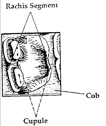 Figure 40. Corn cob morphology.
105
for a relatively early date for the introduction of maize into the Eastern Woodlands (Asch and Asch 1977; Berry 1985; Ford 1981; Yarnell 1976). The maize recovered from Feature 1024 at HT37, which was radiocarbon dated at 1650 ± 70 B.P., is therefore some of the earliest ever reported in the eastern United States. As it stands now, it appears that while maize may have been included in Middle Woodland subsistence regimes, it probably did not play a major role in prehistoric diets until the Late Woodland Period (ca. 750 A.D.) (Asch and Asch 1985, 1985a; Johannessen 1984).
Figure 40. Corn cob morphology.
105
for a relatively early date for the introduction of maize into the Eastern Woodlands (Asch and Asch 1977; Berry 1985; Ford 1981; Yarnell 1976). The maize recovered from Feature 1024 at HT37, which was radiocarbon dated at 1650 ± 70 B.P., is therefore some of the earliest ever reported in the eastern United States. As it stands now, it appears that while maize may have been included in Middle Woodland subsistence regimes, it probably did not play a major role in prehistoric diets until the Late Woodland Period (ca. 750 A.D.) (Asch and Asch 1985, 1985a; Johannessen 1984).
The maize from the well and other features at HT55 probably is from Eastern Eight Row (see Cutler and Blake 1976), although the cob fragment from the site has twelve rows (see Cutler 1986).
Taxa Identified—Wood Charcoal and Carbonized Nuts
Much of the information from each taxon is from Harow and Harrar (1969). When possible, wood charcoal and nuts were identified to the species level. However, the carbonization process often leads to the loss of important anatomical characters and this results in specimens being classified only to the family or genus level.
Carpinus carolinana(Hornbeam)
Hornbeam is a member of the Betulaceae (Birch) family, and is the only species native to the eastern United States. It often occurs in stream bottoms and adjacent slopes, where it usually occurs in the understory of mixed hardwoods. In Missouri, its hard wood was made into yoke timbers and small woodenware in the historic period (Settergen and McDermott 1977).
Carya spp. (True Hickory/Thickshell Hickory)
Hickories are members of the Juglandaceae (Walnut) family. True hickories, so-called to differentiate it from pecan hickories, include, among its eight species, C. ovata (Shagbark), C. laciniosa (Shellbark), and C. tomentosa (Mockernut). Hickories have established niches along moisture gradients and grow in a variety of different habitats, e.g., everything from very mesic, swampy habitats (C. aquatica) to very xeric habitats (C. tomentosa).
The hickories have been used historically for such things as tool handles (wood), chairseats (bark and cambium), food (nuts), and syrup (sap). Most species have good nut mast every 1-3 years, and each tree produces between 1½ and 3 bushels of nuts (Schopmeyer 1974). However, yields can be reduced drastically by such things as natural cyclicity and pests. Hickories have one of the highest Comparative Heat Values (CHV) of wood genera or species (Zawacki and Hausfater 1969).
Celtis occidentalis(Hackberry)
Hackberry, a member of the Ulmaceae (Elm) family, is one of five species of the genus Celtis found in the United States. Found on rich bottom lands, hackberry is resistant to periodic flooding. Its wood was used historically in making barrel hoops (Settergren and McDermott 1977). It also has a relatively low CHV (Zawacki and Hausfater 1969).
Gleditsiaspp. (Locust)
There are two native species of locust, G. triacanthos (Honeylocust) and G. aquatica (Water Locust). Both prefer moist bottom land habitats, although the honeylocust can be found in xeric as well as mesic habitats. The wood of the honeylocust is used for fence-posts, railroad ties and furniture (Settergren and McDermott 1977). The wood also has a very high CHV, approaching that of hickory (Zawacki and Hausfater 1969).
Pinus spp. (Pine)
Identification is based both on wood anatomy (e.g., the presence of resin canals) and comparison to modern, carbonized specimens. Six genera and about 35 species of pine are found in the United States, many species of which are found in the Eastern and Southeastern United States. Pine can be a very good fuel source, as it has a very high CHV (Zawacki and Hausfater 1969). A possible pine cone fragment was recovered from Feature 1024 at 44HT37.
Plantanus occidentalis(American Sycamore)
American sycamore is one of three species of Plantanaceae (Sycamore) family found in the United States. It is the largest of the eastern hardwoods, often reaching heights of 100 feet and diameters of three to eight feet. Sycamore is found in mesic habitats and often is found in wide groves on rich bottom lands. Although its wood is hard, tough, and difficult to split, it has been used in butcher blocks, furniture, crates and barrels (Settergren and McDermott 1977).
Quercus spp. (Oak)
The oaks are members of the Fagaceae (Beech) family, and 58 species are native to the United States. Two subgenera are recognizable paleoethnobotanically: the White Oak group (Leucobalanus) and the Red Oak group (Erythrobalanus). The former includes white oak (Q. alba) and bur oak (Q. macrocarpa). Members of the latter group include live oak (Q. virginiana), willow oak (Q. phellos), water oak (Q. nigra), and southern red oak (Q. falcata).
An acorn cap fragment was recovered from Feature 1003 at HT37. Although acorn remains often are found in archaeological contexts in the Eastern Woodlands, it is probable that acorns did not play a significant role in prehistoric subsistence regimes (Ford 1979). Although acorn meats of some species are edible, collecting and processing of acorns is very labor-intensive. Cyclicity, pests, and competition from fauna probably made scheduling difficult and reliance on acorns as a food source a risky strategy for prehistoric groups in the Eastern United States.
Family Salicaceae (Willows)
In North America, the Willow family is represented by 120 species, 70 of which are of the genus Salix (Willow) and 10 of the genus Populus (Poplar). The former usually are found in mesic habitats, such as those along streams and rivers, while the latter occur in a variety of bottom land and upland habitats.
Summary of Results
Site 44HT36
Fourteen samples from ten features were recovered at the site and analyzed (Table 18). Of the taxa identified, none is a cultivated or domesticated taxon. All seeds and seed fragments were badly eroded, making identification extremely difficult. Because of the paucity of remains, it is impossible to speculate about season of occupation and plant-use strategies of the site's inhabitants.
Site 44HT37
Thirty samples from twelve features were analyzed (Table 19). The data generated indicated the site was occupied at least in the fall/winter. This conclusion is based on the presence of an acorn fragment, nut shell remains, a possible maize kernel fragment (a late summer/early fall crop), and the presence of late summer/fall seeds. However, remains of possible plant foods are rare, and this makes it impossible to ascertain either the exact nature of plant-use strategies or the role of cultivated/domesticated taxa in Middle Woodland subsistence strategies.
| Feature # | Provenience | Contents |
|---|---|---|
| 4 | bulk sample | 1 Graminceae seed |
| 5 | 90S 40E flotation | |
| bulk sample | none | |
| 19 | 130S 30E bulk sample | unidentified carbonized wood |
| 22 | bulk sample | none |
| 42 | 1 unidentified seed fragment | |
| 42 | 2 Nyssa spp. seed fragment | |
| 47 | 2 unidentified seed fragments | |
| 48 | 3.12% | 1 unidentified carbonized frag. |
| 71 | 0'-1' | 1 Galium spp. (Bedstraw) |
| 2 unidentified seed fragments | ||
| 71 | 0'-1' bulk sample | none |
| 71 | 2'-3' bulk sample | none |
| 79 | 120S 70E bulk sample | 1 unidentified seed coat frag. |
| 120 | 0'-.9' | 1 unidentified seed fragment |
| 120 | Top 0'-.9' flotation | none |
Site 44HT55
The 70 samples from this site produced a wealth of data relative to historical plant use and agriculture as well as the kinds of native plant taxa exploited for food and material (Table 20).
Three field crops (Wheat, Type I and Type II) are present in samples from Trash Pit D and the well. Remains of what was probably Eastern Eight Row maize were recovered from several features at the site. Several wood taxa were identified, and these taxa probably represent exploitation of several different microenvironments and their associated floral complexes, e.g., bottom land oak-hickory forest, coastal wetlands, and upland pine forests (see Mouer 1987a).
Conclusions
Paleoethnobotanical analysis of 114 samples from three sites in Hampton produced some information relative to prehistoric and historic use of the environment and the subsistence strategies of some human groups. Most importantly, this initial study demonstrates that explicit sampling strategies with machine flotation of soil samples can generate data critical to formulating a more complete understanding of past foodways.
108| Feature # | Provenience | Contents |
|---|---|---|
| 1001 | fresh seed | |
| 1001 | bulk sample | none |
| 1002 | 220N 140W | fresh seed |
| 1002 | bulk sample | carbonized wood |
| unidentified carbonized material | ||
| 1003 | wet screen | carbonized wood |
| 1003 | none | |
| 1003 | bulk sample | fresh seeds |
| carbonized wood | ||
| unidentified carbonized material | ||
| 1003 | bulk sample | fresh seeds |
| carbonized wood | ||
| unidentified carbonized material | ||
| 1003 | 220N 140W bulk sample | none |
| 1003 | 220N 150E | carbonized wood |
| 1 acorn cap frag. (Quercus spp.) | ||
| 1 unidentified seed | ||
| 1 Galium spp. (Bedstraw) | ||
| 1 Carya spp. (Thickshell Hickory) shell | ||
| 1004 | 220N 150W | bulk sample fresh seeds |
| 1005 | 220N 150W | unidentified carbonized material |
| 1007 | 220N 150W | bulk sample fresh seeds |
| carbonized wood | ||
| 1007 | 220N 150W | bulk sample 1 cf. Cyperaceae (Sedge family) |
| 1 Galium spp. (Bedstraw) | ||
| 6 unidentified seeds | ||
| 1007 | water screened | 1 unidentified seed fragment |
| carbonized wood | ||
| 1015 | 1/8 bulk sample | fresh seeds |
| 1 unidentified seed | ||
| carbonized wood | ||
| 1015 | 1/8 bulk sample | carbonized wood |
| 1018 | 1/5 wet screen | carbonized wood |
| 1018 | 6.25% bulk sample | fresh seeds |
| carbonized wood | ||
| 1018 | 6.25% bulk sample | none |
| 1024 | middle 3.12% | fresh seeds |
| 1 Juglandaceae (Walnut family) shell | ||
| 1 unidentified seed fragment | ||
| 1024 | top 3.12% | 1 Galium spp. (Bedstraw) fragment |
| 3 unidentified seed fragments | ||
| carbonized wood | ||
| 1024 | wet screened | 1 pine cone (Pinus spp.) fragment |
| 2 unidentified seed fragments | ||
| carbonized wood | ||
| 1024 | 1 Carya spp. (Thickshell Hickory) | |
| 1 Polygonaceae (Smartweed family) | ||
| carbonized seed | ||
| 109 | ||
| 1 possible Zea mays kernel fragment | ||
| unidentified carbonized material | ||
| 1024 | bulk sample | carbonized wood |
| 1026 | 200N 160W | none |
| 1054 | 12.5% | 1 unidentified seed fragment |
| 1054 | 12.5% bulk sample | carbonized wood |
| unidentified carbonized material | ||
| 1087 | 12.5% bulk sample | carbonized wood |
| 1087 | 12.5% bulk sample | unidentified carbonized material |
| Provenience | Contents |
|---|---|
| Feature 4 - Trash Pit B | 1 Zea mays kernel |
| 2 unidentified seeds | |
| carbonized wood | |
| fresh seeds | |
| 1 Zea mays cupule fragment | |
| 3 Zea mays kernel fragments | |
| 1 Carya spp. (Thickshell Hickory) | |
| nut shell fragment | |
| carbonized wood | |
| Pinus spp. (Pine) | |
| Carya spp. (True Hickory) | |
| Quercus spp. (Oak) | |
| Platanus occidentalis (Sycamore) | |
| Feature 12 - Trash Pit A | fresh seeds |
| 2 Galluim spp. (bedstraw) | |
| 1 unidentified seed | |
| carbonized wood | |
| Feature 19 - Trash Pit B | carbonized wood |
| Quercus spp. (Oak) | |
| Carya spp. (True Hickory) | |
| 1 Gramineae (Grass family) stem | |
| 3 Zea mays kernel fragments | |
| fresh seeds | |
| Feature 21 - Trash Pit A | fresh seeds |
| 1 Galium spp. (bedstraw) | |
| 7 Zea mays rachis segments | |
| 1 Zea mays cupule fragments | |
| Feature 25 - Trash Pit A | fresh seeds |
| carbonized wood | |
| Carya spp. (True Hickory) | |
| 110 | |
| Feature 26 - Trash Pit C | carbonized wood |
| Quercus spp. (Red Oak) | |
| Feature 36 - Trash Pit F | fresh seeds |
| carbonized wood | |
| Quercus spp. (White Oak) | |
| Carya spp. (True Hickory) | |
| Feature 37 - Trash Pit G | 1 Galium spp. (Bedstraw) |
| Feature 38 - Trash Pit G | carbonized wood |
| 35 Zea mays cupules | |
| 3 Zea mays kernel fragments | |
| 100+ Zea mays cupule fragments | |
| Feature 45 - Trash Pit G | fresh seed |
| 1 Chenopodiaceae (Goosefoot family) | |
| 2 Zea mays kernels | |
| 3 unidentified seeds | |
| carbonized wood | |
| 3 Zea mays cupule fragments | |
| 1 unidentified legume (Leguminosae) seed | |
| Feature 48 - Trash Pit G | fresh seeds |
| Feature 49 - Trash Pit D | 3 Triticum spp. (Wheat) |
| 2 unidentified seeds | |
| fresh seeds | |
| 1 carbonized stem | |
| Gramineae (Grass family) | |
| carbonized wood | |
| 1 unidentified seed fragment | |
| Feature 62 - Trash Pit H | 1 Zea mays kernel fragment |
| fresh seed | |
| carbonized wood | |
| cf. Carpinus caroliniana (Hornbeam) | |
| Feature 83 | fresh seeds |
| carbonized wood | |
| 1 Zea mays kernel fragment | |
| Feature 84 - Trash Pit A | none |
| Feature 96 | fresh seeds |
| cf. 1 Zea mays kernel fragment | |
| Feature 98 - Post Hole | fresh seed |
| carbonized wood | |
| Feature 100 | carbonized wood |
| fresh seed | |
| Feature 104 - Fill | carbonized wood |
| Feature 118 - Trash Pit J | carbonized wood |
| Quercus spp. (White Oak) | |
| Carya spp. (True Hickory) | |
| Salicaceae (Willow family) | |
| Feature 119 - Trash Pit K | carbonized wood |
| Carya spp. (True Hickory) | |
| Salicaceae (Willow family) | |
| 111 | |
| Feature 157 - Post Hole | Prunus persica (Peach) pit |
| Feature 203 - Prehistoric Pit | fresh seeds |
| Cellar Fill | fresh seed |
| carbonized wood | |
| Feature 257 | fresh seeds |
| carbonized wood | |
| Celtis occidentalis (Hackberry) | |
| Carya spp. (True Hickory) | |
| Well - Layer 107 | unidentified seeds |
| carbonized wood | |
| Well - Layer 182 | carbonized wood |
| Well - Layer 191 | 1 Zea mays kernel fragment |
| Well - Layer 241 | carbonized wood |
| Well - Layer 242 | carbonized wood |
| 1 Zea mays cob fragment (12 rows) | |
| cf. Eastern Eight Row | |
| 76 Type I (Wheat) seeds | |
| 3 Cyperaceae (Sedge family) | |
| 1 unidentified seed fragment | |
| carbonized wood | |
| Salicaceae (Willow family) | |
| Quercus spp. (White Oak) | |
| Quercus spp. (Red Oak) | |
| Quercus spp. (Oak) | |
| Gleditsia spp. (Locust) | |
| Carya spp. (True Hickory) | |
| Pinus spp. (Pine) | |
| 6 Zea mays kernel fragments | |
| 7 Zea mays cupule | |
| 60 Type II seeds (Wheat) | |
| Well - Layer 242 | 1 legume cotyledon |
| (cf. Strophostyles spp.) | |
| 2 Zea mays cupule fragments | |
| 1 Convolvulaceae (Morning Glory) | |
| 25 unidentified seed/seed coat frags. | |
| Well - Layer 297 | carbonized wood |
| fresh seed | |
Chapter 7. Artifact Analysis—44HT55
Introduction
The artifact assemblage retrieved from site 44HT55 during the 1987-1988 season is international in scope and suggestive of a relatively high-status colonial residence of the first half of the seventeenth century. In the early colonial period, this portion of Hampton is believed to have been part of the glebe lands set aside for the support and use of the clergy assigned to the Kicoughtan Parish. The close proximity of this site to the well-known and documented site of the Second Church of Kicoughtan supports this premise.
As researchers such as Barbara Carson have indicated in their studies of the seventeenth-century material culture of Saint Mary's City, Maryland, that relative wealth can be measured in terms of the diversity and quantity of artifact types through time (Carson 1984). Others, such as L. Daniel Mouer, have suggested that an interpretation of relative status is better understood when seen in terms of social, geographic, and economic systems which are affected by locality and proximity. The status of the inhabitants of HT55, according to Mouer's interpretation, would have been relatively high due to their affiliation with the religious hierarchy and political power structure in force in Tidewater Virginia (Mouer 1987b:22). This social position afforded them the ability to take advantage of the wealth/power base at work in the early Virginia social structure and allowed them to acquire better-than-average consumer goods.
In order to place the HT55 assemblage into social and economic context within this framework, as well as to assist the characterization of the artifact assemblage in terms of function and contemporaneous relationships among the various features on the site, it was necessary to compare this assemblage with the finds from other sites of similar date. The early date of occupation at HT55 as indicated by the artifacts and the architecture, as well as the strategic location of the site on Hampton Roads, prompted inquiry into whether this settlement could be considered a "frontier settlement" or a more cosmopolitan base of habitation and commerce equivalent to Jamestown Island.
The initial assumption was that the HT55 artifact assemblage should differ from assemblages retrieved from settlements further along the James River in terms of quality, quantity, and point of origin. This initial supposition seemed plausible until comparisons were made with other assemblages, specifically, the material recovered at the College Landing site (44WB49), Jamestown Island, and the Causey's Care (Walter Aston) site near the modern-day city of Hopewell.1 Direct comparisons with these assemblages revealed a striking similarity in the quality of the objects recovered. Perhaps the most striking comparisons occurred between HT55 artifacts and exact or similar parallels found at the Causey's Care site some eighty miles west, above the mouth of the James River.The finds at this location are so similar to those of HT55 as to call into question the original premise that proximity to the mouth of the river and immediate access to foreign shipping would be reflected in the quantity and quality of goods. The fact that the same kinds of ceramic wares and, to a lesser extent, artifacts from the same diverse foreign origins suggests not only trans-Atlantic trade networks, but some means of local distribution along the James River.
114The ever-increasing sphere of Dutch and English influence in the Caribbean and the coincidental inability of Spain to adequately supply her colonies in the New World may well have contributed to the development of trade networks which supplied North America (Deagan 1987:21; Ver Steeg 1964:109). The oblique references to Dutch trading in Virginia as early as 1611 (Wilcoxen 1987:19) and references to Spanish ships in the Tidewater/Chesapeake Bay area as early as 1615-16 (Smith 1624:119) certainly indicate the presence of foreign vessels and possibly traders who may have distributed goods along the river.
The settlement and land-use patterns of the English colonists, as revealed through demographic studies such as those conducted by Kevin Kelly for the County of Surry, may be taken as typical for the lower James River Basin in the period 1620 through 1650. Kelly's research demonstrates that the development of settlements and plantations is inextricably tied to economics and trade. As long as tobacco was the principal cash crop of the early English colonists, settlement was restricted to areas along navigable tributaries or major confluences of the James River which would allow for easy transportation of the crops. It was only after the collapse of the tobacco-based economy during the 1680s that the settlement patterns changed significantly (Kelly 1979:196-197). Not until the second half of the seventeenth century did the tobacco-exhausted soil forced expansion into the hinterlands which were not within the James River watershed. This movement of the settled areas away from the James River and the opening of new lands to cultivation had a profound change in the trade networks that provided consumer goods to colonial Virginians.
Laboratory Methods
All of the artifacts retrieved from HT55 were processed and analyzed in accordance with the standard operating procedures used by the Department of Archaeological Research. The artifacts were received from the field daily and were logged in by context number, with the number of bags noted. Each context was washed separately to avoid contamination from other artifact groups, and then sorted by artifact type. Deposition dates (termini post quem) were assigned wherever possible, based on the most recent artifact present in each context group. The ceramic sherds and diagnostic glass container fragments were numbered with the site and context number. Organic and metal objects were numbered with string tags or were sealed into appropriately-sized polyethylene bags.
The finds were quantified and inventoried using the dBase III-based artifact inventory system currently used by the D.A.R. This system consists of coded fields which identify the archaeological context, a depositional date for the artifact group, quantity of artifacts in each type in the group, and an eight-digit code that identifies and describes the object or objects. Inventory data was initially accumulated in a handwritten format on specially designed coding sheets which were later used for direct data-entry, using an IBM Model 30 personal computer in the field laboratory. A complete copy of the artifact inventory is included in Volume II.
Treatment levels, which are customarily assigned to artifact groups in the field to aid in the prioritization of work, were not employed at this site as the unique character and period of the site and the relative antiquity of the features made this designation unnecessary. As the vast majority of contexts were undisturbed sub-plowzone seventeenth-century features, they were all given the highest level of treatment and analysis.
Fragile objects or materials, such as worked bone and glass, which were deemed in need of immediate conservation intervention were removed from their context groups and sent to the Archaeology Laboratory of the D.A.R. for stabilization. Some twenty-five objects, mostly organic or glass, were treated in this manner. Faunal material was washed in the same manner as the rest of the artifact assemblage and was then sorted into identifiable and non-identifiable fragments. 115 This faunal material was set aside for later analysis and quantification (see Chapter 6C).
The analysis of the artifacts continued with crossmending. It was decided to crossmend the ceramics first in the hope that this analysis would be sufficient to provide an interpretation of the site without the need to crossmend the glass. This proved to be the case early in the analysis phase; due to limited time and laboratory staff, it was thus decided not to proceed beyond the minimum vessel count for glass. The ceramics were crossmended by type, and a minimum vessel count for each ware type and vessel form was compiled. A complete crossmend list by object is included in Volume II. This information was used in the statistical analysis of the vessel forms retrieved from the site and demonstrated the contemporaneity of several of the major features.
The criteria used in establishing unique vessels was dependant on significant rim, base, or body characteristics, ceramic body and glaze types, and considerations of the size and color of the body or glaze. The minimum count for glass bottles was obtained by counting only the bases and necks which were at least 50% or more complete. Necks or bases which were less than half present were counted along with the non-diagnostic body fragments. The larger number of necks or bases determined the final count. All glass vessel body sherds were also examined during inventory encoding to ascertain if any fragments were from round bottles instead of square or case bottles. It turned out, however, that all fragments from discrete features were from case or square- molded bottles, which predominated prior to circa 1650.
Crossmending provided the correlations between the major features of the site. As vessels were recognized and re-assembled, they were assigned a sequential catalog number. In addition, the mending fragments which were glue-fits were recorded, along with non-contiguous but related fragments for each vessel. The recording was initially done on the standard 3" x 5" forms used for this purpose by the D.A.R.; the data was later entered into the crossmend record portion of the object catalog for further computer-assisted analysis. This analysis, which consisted of groupings by function, form, and type, was used to determine the nature of the fill of the major features, as well as the possible functions or activities that were taking place on the site.
Most of the distributional analysis was accomplished directly from the hard copy of the artifact inventory, sorted by feature and macro-feature, and plotted directly on the overall site map. Through this analysis it was possible to draw conclusions of the character of the household(s), refuse disposal processes, and areas of specific activity across the site.
Following all analysis, the crossmending aggregations and non-contiguous sherds were numbered with the catalog number, and written documentation in the form of crossmend slips were put into each context group from which fragments were taken in the crossmending process. These crossmend slips represent the missing sherds and indicate the new storage location of the fragments. All of the sherds which represent a unique vessel were stored together in whichever context yielded the greatest number of fragments. The bagged and catalog-numbered vessels were returned to the appropriate context unit in preparation for final storage.
Final storage was accomplished by bagging all the artifacts from each context in appropriately-sized polyethylene bags and boxing them in sequential order by context number. Several of the larger mended vessels were not stored, but instead were set aside for ceramic restoration and eventual exhibition.
The metal and organic objects which were retrieved from the site were separated from the ceramics, glass, architectural components, and the majority of nails. Those objects in need of conservation were documented with pre-treatment photographs and conservation treatment records. These records included, in most cases, a sketch of the object(s) prior to conservation and written documentation as to the initial treatment of the object. A list of these objects was then compiled and the objects were prioritized according to their 116 relative need for immediate treatment. Those objects which were most complete, identifiable, unique to the assemblage, or crucial to the interpretation of the site received the highest rating as they required immediate conservation. Those items which were somewhat redundant, composed of less friable material, or which were deemed more stable, were given a lower rating for a later conservation effort.
All iron objects were X-rayed to assist with positive identification of anonymous objects and to serve as an additional form of graphic documentation. A preliminary sample of 176 iron nails was pulled from the various layers of the major features on the site. This sample was documented with X-ray radiography and photography. From this preliminary sample, a secondary sample of nails based on feature was pulled for actual conservation. Copper alloy objects, which were basically stable, were not X-rayed, nor were the organic objects which were stabilized in the Conservation Laboratory of the D.A.R. All the artifacts in the conservation group were turned over to Mr. Curtis Moyer of the College of William and Mary for treatment.
The bagged and boxed ceramics and glass were turned over to Hampton University for curation and exhibition, along with computer printouts of the artifact inventory, object catalog, crossmend lists, and all other pertinent documentation.
Ceramics
The ceramic assemblage retrieved from site HT55 during the 1987-1988 excavation season is surprisingly international in scope, containing ceramic wares not only of local manufacture and from England, but from various countries on the European continent. The presence of this diversity of wares in such an early and relatively small domestic setting is suggestive of a high-status residence or one which had sufficient financial power to take advantage of both foreign-based and domestic trade networks. The occurrence of identical, or at least similar, objects at settlement sites along the James River Basin suggests the extent to which trade and the distribution of imported commodities had developed in Tidewater Virginia by the first half of the seventeenth century. Imported ceramic and glass wares from such diverse regions as Italy, Spain, England, Portugal, and the Low Countries are a strong indication of the relative status of the household(s) which occupied HT55 during the earliest years of colonization.
Feature Correlations
The crossmending analysis of the ceramic remains revealed several contemporaneous relationships among major features on the site. The well and the large trash pits (Trash Pits A and B), located just north of Structure A, were proven contemporaneous by crossmends in a locally-made coarse earthenware vessel believed to be a strainer (Catalog Number 1143; see Photo 15) and by crossmends in four Portuguese tin-enamelled ware plates (Catalog Numbers 1037, 1038, 1039, and 1040). Trash Pits D and H were proven contemporaneous by a crossmend in a Westerwald stoneware jug (Catalog Number 1071). Trash Pit A and the cellar fill of Structure A were proven contemporaneous by a crossmend in a vessel believed to be an English stoneware butterpot (Catalog Number 1085) and another in a coarse earthenware storage jar (Catalog Number 1140). Three small trash pits and the western fence slot complex (Trash Pits F, G, H and Slot Fence A) were proven related by a crossmend in a large coarse earthenware milk or cream pan (Catalog Number 1094). Trash Pit F and Trash Pit A are related through a crossmend in a coarse earthenware porringer (Catalog Number 1153). Trash Pits B and F were proven contemporaneous by a crossmend in a coarse earthenware unglazed flask or bottle (Catalog Number 1155).
Through this analysis, it was established that the well to the southwest of the site, the cellar fill of Structure A, the large trash pits just north of Structure A, and the smaller trash pits and fence
117
 Photo 15. Red earthenware strainer, interior and side views with profile.
complex to the west of the site were contemporaneous features.
Photo 15. Red earthenware strainer, interior and side views with profile.
complex to the west of the site were contemporaneous features.
The white clay tobacco pipes from HT55 were also crossmended and yielded further evidence of contemporaniety among features on the site. The presence of a marked tobacco pipe bowl (Catalog Number 6123), which may be attributable to the London pipemaker William Collins, who died in 1686 (Oswald 1970:138), provides a terminus ante quem for the construction of Structure A (for details, see the discussion of pipe stem crossmending below). The ceramic artifacts retrieved from Structure A and the major features of the site suggest a date of construction some time during the first half of the seventeenth century.
Ware Type Profile
Site HT55 produced 128 identifiable ceramic vessels (Table 21). The majority of those vessels (67, or 52.3%) were coarsewares. These wheel-thrown vessels were composed of an earthenware body which was often coated with a clear lead-fluxed glaze. Because they were easy to produce and relatively inexpensive to purchase (I. Noël Hume 1969:102), coarsewares often formed the core of a colonial-period vessel assemblage, especially of utilitarian wares. It is not coincidental, then, that the overwhelming majority of vessels associated with food preparation, processing, and storage in the HT55 assemblage were coarsewares. Locally-made red coarsewares comprised 38 of the 67 coarseware vessels. The remaining 29 vessels were imported from England, Italy, Spain, and possibly from Central America (Figure 41).
One small, thinly-potted, unglazed earthenware vessel (Catalog Number 1155; see Photo 16) was retrieved from Trash Pits B and F. This vessel is unique among the ceramic forms not only in its form, a short, bulbous flask shape, but also in the clay body from which it was made. This red earthenware contains a large proportion of micaeous material in the clay body, which is easily visible to the unaided eye. It is possible that this vessel may be of Central American origin, possibly from Mexico (I. Noël Hume, personal communication).
| No. | % | |
|---|---|---|
| COARSE EARTHENWARES | ||
| Fire clay crucible | 1 | 0.8 |
| Iberian | 2 | 1.6 |
| Local red earthenware | 38 | 29.7 |
| North Devon plain | 3 | 2.3 |
| North Italian slipware | 1 | 0.8 |
| North Netherlands slip trailed | 2 | 1.6 |
| Staffordshire white sandyware | 18 | 14.1 |
| Surreyware | 1 | 0.8 |
| West of England slip sgrafitto | 1 | 0.8 |
| 67 | 52.3 | |
| TIN-ENAMELLED WARES | ||
| English delftware | 13 | 10.2 |
| Faience | 17 | 13.3 |
| Portuguese faience | 9 | 7.0 |
| Spanish Majolica | 3 | 2.3 |
| Tin-enamelled | 8 | 6.3 |
| 50 | 39.1 | |
| STONEWARES | ||
| German brown | 4 | 3.1 |
| Staffordshire | 1 | 0.8 |
| Westerwald | 6 | 4.7 |
| 11 | 8.6 | |
| TOTAL | 128 | 100.0 |
Note: Chinese porcelain was also recovered from HT55, but the fragments were too small to make a positive vessel form identification. Accordingly, they have been excluded from this listing.
119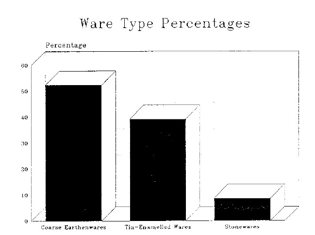 Figure 41. Percentages of ware types represented.
While coarseware vessels were the most numerous, tin-enamelled wares were also well represented within the ceramic vessel assemblage. Delftware, faience, and majolica were among the several varieties of tin-enamelled ware that were encountered. Made from an earthenware clay body, tin-enamelled wares are distinguished by their glaze, which is obtained by opacifying a clear lead glaze with tin oxide. Compounds of cobalt, manganese, iron, copper, or antimony were commonly painted on such wares to produce colorful decorations. In the HT55 assemblage, these wares numbered 50 vessels, comprising 39.1% of the total.
Stonewares, including vessels produced in the Rhineland and decorated with either cobalt blue on a gray body or iron oxide brown, were not well represented in the vessel assemblage. Similarly, only one stoneware vessel identified as a Staffordshire butterpot was identified. These wares have a high-fired ceramic body that is heated to the point of vitrification. Stonewares are generally glazed with common salt to give their exteriors a characteristic orange-peel texture. Stonewares, primarily German in origin, have been found on many seventeenth-century sites in the Chesapeake. These durable European wares were imported to the colonies through England in considerable quantities throughout this period (I. Noël Hume 1978:276). Therefore, it is surprising that there were only 11 stoneware vessels in the assemblage, 8.6% of the total.
Form and Function Analysis
To facilitate the analysis of the ceramic assemblage, vessels were further categorized according to their form and possible function (Tables 22 and 23). Of the 128 vessels identified initially, the five unidentified forms and the crucible were omitted from this section of the analysis. Each of the remaining 122 vessels was examined individually to judge its exact shape and size based on diagnostic characteristics of rim, base, and body.
120
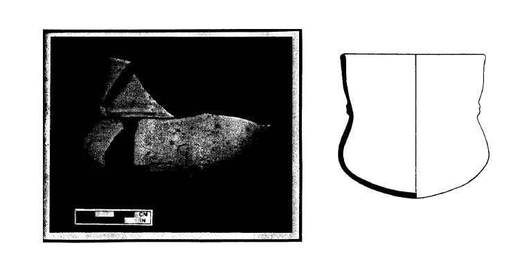 Photo 16. Unglazed earthenware flask, Mexican (?), with profile.
These evaluations were used, along with the ceramic type, to determine a specific form designation for each identifiable vessel. Vessels of like physical appearance were then grouped together according to their functional role within the domestic setting, and six functional categories were created. The largest group consisted of those vessels used for food serving and/or consumption. It included such seventeenth-century tablewares as bowls, dishes, plates, porringers, tygs, mugs, and assorted hollowwares that were used for the presentation or consumption of food or beverages. Storage vessels were those forms such as jugs, olive jars, butter pots, storage jars and flasks, which were used for the containment or transportation of food or liquid awaiting consumption. Several costrels and unidentified hollowwares were placed in a separate category of serving/storage containers to reflect their dual functions. Vessel forms used for domestic food processing, preparation, and cooking included pipkins, pans, and colanders/strainers.
Photo 16. Unglazed earthenware flask, Mexican (?), with profile.
These evaluations were used, along with the ceramic type, to determine a specific form designation for each identifiable vessel. Vessels of like physical appearance were then grouped together according to their functional role within the domestic setting, and six functional categories were created. The largest group consisted of those vessels used for food serving and/or consumption. It included such seventeenth-century tablewares as bowls, dishes, plates, porringers, tygs, mugs, and assorted hollowwares that were used for the presentation or consumption of food or beverages. Storage vessels were those forms such as jugs, olive jars, butter pots, storage jars and flasks, which were used for the containment or transportation of food or liquid awaiting consumption. Several costrels and unidentified hollowwares were placed in a separate category of serving/storage containers to reflect their dual functions. Vessel forms used for domestic food processing, preparation, and cooking included pipkins, pans, and colanders/strainers.
While the functional nature of most of the ceramic vessels involved the preparation, storage, or consumption of food or drink, a number of non-food related vessels attest to several of the many other domestic needs on the site. Numerous drug pots used for the storage of dry medicinal preparations were placed in a separate category of pharmaceutical vessels. The two chamber pots were likewise categorized separately as toiletry vessels.
According to these functional categories, the food serving vessels constituted the largest percentage (39.3%) of the total ceramic vessel assemblage (Figure 42). Of the 122 vessels studied and regrouped by their function, forty-eight were probably used for serving food. Vessel forms in this category included: 2 dishes (1.6%), 3 pans/ dishes (2.5%), 10 bowls (8.2%), 28 plates (23%), 1 plate/shallow bowl (0.8%), 2 porringers (1.6%), 1 mug (0.8%), and 1 tyg (0.8%). Within this category, it is interesting to note that all of the 28 identified plates are tin-enamelled wares. When the 28 plates are added to the remaining 18 food serving vessels, these 46 food serving and consumption vessels contrast dramatically with the two ceramic drinking vessels which were identified on the site.
Such an uneven ratio of food to beverage consumption vessels might be explained by the occupants' use of leather, wood, or pewter drinking vessels. Such materials were commonly used for drinking vessels in the seventeenth century; 121
| No. | % | |
|---|---|---|
| Bellarmine Jugs | ||
| German brown | 3 | 2.3 |
| 3 | 2.3 | |
| Bowls | ||
| Faience | 1 | 0.8 |
| Local red coarseware | 4 | 3.1 |
| Portuguese faience | 1 | 0.8 |
| White sandy | 4 | 3.1 |
| 10 | 7.8 | |
| Butter Pots | ||
| Staffordshire | 1 | 0.8 |
| 1 | 0.8 | |
| Chamber Pots | ||
| Local red coarseware | 1 | 0.8 |
| White sandy | 1 | 0.8 |
| 2 | 1.6 | |
| Colanders | ||
| Local red coarseware | 1 | 0.8 |
| 1 | 0.8 | |
| Costrels | ||
| Spanish majolica | 3 | 2.3 |
| 3 | 2.3 | |
| Crucibles | ||
| Fire clay | 1 | 0.8 |
| 1 | 0.8 | |
| Dishes | ||
| North Netherlands slip trailed | 1 | 0.8 |
| West of England slip sgrafitto | 1 | 0.8 |
| 2 | 1.6 | |
| Drug Pots | ||
| English delftware | 10 | 7.8 |
| 10 | 7.8 | |
| Flasks | ||
| Unglazed red earthenware | 1 | 0.8 |
| 1 | 0.8 | |
| Hollowwares | ||
| German brown | 1 | 0.8 |
| Westerwald | 1 | 0.8 |
| White sandy | 1 | 0.8 |
| 3 | 2.3 | |
| Jugs | ||
| English delftware | 3 | 2.3 |
| Local red earthenware | 1 | 0.8 |
| Slip-trailed | 1 | 0.8 |
| Westerwald | 4 | 3.1 |
| White sandy | 1 | 0.8 |
| 10 | 7.8 | |
| 122 | ||
| Jugs | ||
| Westerwald | 1 | 0.8 |
| 1 | 0.8 | |
| Olive Jars | ||
| Iberian | 2 | 1.6 |
| 2 | 1.6 | |
| Pans | ||
| Local red earthenware | 12 | 9.4 |
| White sandy | 6 | 4.7 |
| 18 | 14.1 | |
| Pan/Dishes | ||
| Faience | 3 | 2.3 |
| 3 | 2.3 | |
| Plates | ||
| Faience | 12 | 9.4 |
| Portuguese faience | 8 | 6.3 |
| Tin-enamelled | 8 | 6.3 |
| 28 | 21.9 | |
| Plates/Shallow Bowls | ||
| Faience | 1 | 0.8 |
| 1 | 0.8 | |
| Pipkins | ||
| Local red earthenware | 4 | 3.1 |
| White sandy | 2 | 1.6 |
| 6 | 4.7 | |
| Pipkin Lids | ||
| White sandy | 1 | 0.8 |
| 1 | 0.8 | |
| Porringers | ||
| Local red earthenware | 1 | 0.8 |
| North Italian slipware | 1 | 0.8 |
| 2 | 1.6 | |
| Storage Jars | ||
| Local red earthenware | 7 | 5.5 |
| North Devon plain | 2 | 1.6 |
| Surreyware | 1 | 0.8 |
| White sandy | 2 | 1.6 |
| 12 | 9.4 | |
| Strainers | ||
| Local red earthenware | 1 | 0.8 |
| 1 | 0.8 | |
| Tygs | ||
| North Devon plain | 1 | 0.8 |
| 1 | 0.8 | |
| Unidentified | ||
| Local red earthenware | 5 | 3.9 |
| 5 | 3.9 | |
| No. | % | |
|---|---|---|
| Food Serving and Consumption Vessels | ||
| Bowl | 10 | 8.2 |
| Dish | 2 | 1.6 |
| Jug | 1 | 0.8 |
| Pan/Dish | 3 | 2.5 |
| Plate | 28 | 23.0 |
| Plate/Shallow Bowl | 1 | 0.8 |
| Porringer | 2 | 1.6 |
| Tyg | 1 | 0.8 |
| 48 | 39.3 | |
| Storage Vessels | ||
| Bellarmine | 3 | 2.5 |
| Butter pot | 1 | 0.8 |
| Flask | 1 | 0.8 |
| Jug | 10 | 8.2 |
| Olive Jar | 2 | 1.6 |
| Storage Jar | 12 | 9.8 |
| 29 | 23.7 | |
| Serving/Storage Vessels | ||
| Costrel | 3 | 2.5 |
| Hollowware | 3 | 2.5 |
| 6 | 5.0 | |
| Food Processing and Preparation Vessels | ||
| Colander | 1 | 0.8 |
| Pan | 18 | 14.8 |
| Pipkin | 6 | 4.9 |
| Pipkin Lid | 1 | 0.8 |
| Strainer | 1 | 0.8 |
| 27 | 23.7 | |
| Toiletry Vessels | ||
| Chamber Pot | 2 | 1.6 |
| 2 | 1.6 | |
| Pharmaceutical Vessels | ||
| Drug Pot | 10 | 8.2 |
| 10 | 8.2 | |
| TOTAL | 122 | 99.9 |
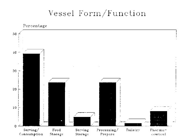 Figure 42. Vessel form/function.
Vessels used for food storage made up the next largest group with 23.7% of the total. Of the 29 vessels in this category, there were 12 storage jars (9.8%), 10 jugs (8.2%), 3 bellarmine jugs (2.5%), 2 olive jars (1.6%), one flask (0.8%), and one butter pot (0.8%). Coarsewares, tin-enamelled wares, and stonewares were all present in this functional category; they included both locally-made and imported varieties. A separate category, which contained 3 costrels (2.5%) and 3 miscellaneous hollowwares (2.5%), was created to reflect both the food serving and storage capacities of these vessels. This category contained solely imported wares and accounted for only 5% of the total vessel assemblage.
The 27 vessels associated with the processing and preparation of food represented 22.1% of the total. Eighteen pans (14.8%), 6 pipkins (4.9%), 1 pipkin lid (0.8%), 1 colander (0.8%), and 1 possible strainer (0.8%) made up the vessel forms in this category. It is noteworthy that of these 27 vessels, two-thirds were identified as pans. Such a large quantity of pans of the size and configuration traditionally used for processing dairy products suggests that dairy-related activities may have been an important part of the seventeenth-century domestic routine on this particular site. In addition, a large hollowware vessel with a single centrally-located drain hole in its base is believed to be a strainer used to separate whey from curds. This would have been an indispensable vessel in the production of cheese.
Local Coarsewares
The extensive use of locally-made earthenware vessels indicates the possible presence of itinerant, skilled potters who filled a need for utilitarian vessels not satisfied by the imported vessels. The production of locally-made pottery has been documented
by Noël Hume at several of the major sites at Martin's Hundred, where spectrographic analysis of the clay bodies proved them to be of Virginia manufacture (I. Noël Hume 1982:105108). A wide range of ceramic forms and pottery wasters, believed to have been produced and discarded
125
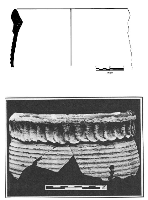 Photo 17. Thumb-impressed earthenware storage jar, with profile.
126
Photo 17. Thumb-impressed earthenware storage jar, with profile.
126
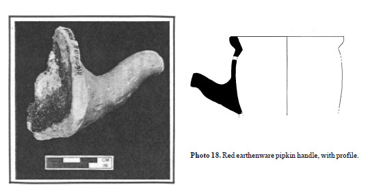 Photo 18. Red earthenware pipkin handle, with profile.
 Photo 19 (below). Unglazed pipkin lid, with profile.
127
on or near Site "C" (1618-1622) and Site "B" (post-1631), have been retrieved from the Martin's Hundred site, but unfortunately, the kiln sites have not yet been discovered (I. Noël Hume 1982). Coarse earthenwares with the same visual characteristics as those from Martin's Hundred were represented among the HT55 ceramic assemblage. There are striking similarities in the appearance of the various locally-made ceramics, in terms of form and decorative characteristics on all of the major sites along the James River (see Photos 17 and 18). Additionally, coarse earthenwares with the same distinctive "Martin's Hundred" clay body (the terminology used by Bly Bogley Straub in finds inventories for the Causey's Care site), though with somewhat different potting styles, were excavated from the College Landing site further up the James River.
Photo 19 (below). Unglazed pipkin lid, with profile.
127
on or near Site "C" (1618-1622) and Site "B" (post-1631), have been retrieved from the Martin's Hundred site, but unfortunately, the kiln sites have not yet been discovered (I. Noël Hume 1982). Coarse earthenwares with the same visual characteristics as those from Martin's Hundred were represented among the HT55 ceramic assemblage. There are striking similarities in the appearance of the various locally-made ceramics, in terms of form and decorative characteristics on all of the major sites along the James River (see Photos 17 and 18). Additionally, coarse earthenwares with the same distinctive "Martin's Hundred" clay body (the terminology used by Bly Bogley Straub in finds inventories for the Causey's Care site), though with somewhat different potting styles, were excavated from the College Landing site further up the James River.
Bly Bogley Straub and other researchers have used the term "Jamestown" to refer to a particular form of domestically-produced coarse earthenware body characterized by a fine, sandy body, which appears as a pale, dusty brownish-grey to a rosy-peach color. The glaze most frequently associated with this body is a soft, dull caramel or greenish caramel-colored lead glaze which is usually applied sparingly to the interior surfaces of the utilitarian forms. This ware type has been documented on the Causey's Care and Jamestown sites, and appears at HT55 in a number of vessel forms. One of the most notable is an unglazed pipkin lid (Catalog Number 1181; Photo 19).
In the author's opinion, the so-called "Martin's Hundred" and Jamestown" wares are, in fact, the same. The differences in glaze color and clay body hardness and color can be attributed to minor variances in firing and chemical composition of the clay used in the manufacture. The control that could be exercised by an itinerant potter who fired his wares in temporary, surface-built kilns may have varied sufficiently to result in immature wares found at Jamestown, HT55, and Causey's Care, but not at Martin's Hundred. Spectrographic analysis of the clay bodies of these locally-made wares, in comparison with documented wares from abroad, is the only reliable method to determine their true origin.
The vessel forms which appear in the so-called "Jamestown ware" and the more common local red earthenwares are very similar in character. The rim configurations of these bowls, storage jars, and milk pan forms are also strikingly similar.
A nearly complete red earthenware storage jar (Catalog Number 1141), which is believed to be of local manufacture, was found in the well at HT55. This vessel (Photo 20) is unique in the configuration of the rim which is quite angular with an internal "step" for a lid.
Imported Earthenwares
Iberian
Site HT55 yielded numerous fragments of coarse earthenwares from the Iberian Peninsula. Most notable among these storage vessels is a narrow-mouthed olive jar (Catalog Number 1206; Photo 21). The form of this vessel coincides with John Goggin's typology as a "middle style type B." Goggin suggests that this shape pre-dates 1671 (Goggin 1964:266). Examples of this vessel type and shape have been found in numerous sites throughout Spanish North and South America. The dating scheme for this ware, developed by Goggin through archaeological stratigraphic sequences, seriation of collections, and associated artifact and historical data, places the middle style type B forms in the period circa 1580 to 1800 (Goggin 1964:276-277). An exact parallel to this vessel in terms of clay body color, texture, surface treatment, and dimension was retrieved from the Causey's Care site.
In addition to the possible Mexican flask (Catalog Number 1155; Photo 16), discussed previously, a large French earthenware storage jar was recovered from Trash Pit A located north of Structure A (see Photo 22). This vessel (Catalog Number 1209) is composed of a fine-grained pale tan clay body with an apple-green glaze on
128
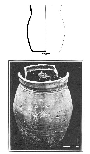 Photo 20. Locally-made earthenware storage jar, with profile.
129
Photo 20. Locally-made earthenware storage jar, with profile.
129
 Photo 21 (above). Iberian oil jar mouth, with profile.
 Photo 22. French earthenware storage jar, exterior and interior views with profile.
130
Photo 22. French earthenware storage jar, exterior and interior views with profile.
130
 Photo 23. North Italian slip marblized porringer handle, with profile.
its interior surfaces. The flattened rim is distinctive, as is the friable clay body.
Photo 23. North Italian slip marblized porringer handle, with profile.
its interior surfaces. The flattened rim is distinctive, as is the friable clay body.
Slip-Decorated
The highly-decorated slipwares of Northern Italy were also represented in the HT55 assemblage. Fragments believed to be part of a slip-marblized porringer (Catalog Number 1223; Photo 23) were retrieved from the well and Structure C. Unfortunately, none of the fragments crossmended. This distinctive ware, which is also known as Pisan-type slipware, is documented by Deagan and others at various sites throughout southern North America and the Caribbean in contexts dating from the first half of the seventeenth century (Deagan 1987:47).
Several fragments of a North Netherlands slipware colander (Catalog Number 1151; Photo 24B) were retrieved from Trash Pit A. This distinctive red earthenware with a green slip, ornamented with sgraffito decoration, was one of several slip-decorated coarse earthenwares of foreign origin. A rim fragment from a North Devon slip-sgraffito platter (Catalog Number 1220; Photo 25) was recovered along with other rim fragments from an over-fired slipware vessel of undetermined origin (Catalog Number 1215; see Photo 24C). Fragments of a German or Dutch slipware dish (Catalog Number 1217; see Photo 24A) were found in features associated with Structure C. A striking parallel to this flat rimmed, and slip-trailed dish was recovered at the College Landing site (Edwards and Pittman 1987).
Tin-Enamelled Wares
Spanish/Portuguese Majolica
The HT55 assemblage contained a number of very unique food consumption vessels of Portuguese or Spanish origin. This ware, characterized by a pale yellow homogeneous body covered with a nearly opaque tin-enamelled glaze, is usually decorated with hand-painting in cobalt blue in various geometric and circular motifs. These vessels are distinctive because of simple painted lines
which appear on the undersides of the plate and bowl rims and a curious dimpling which occurs in the glaze on the undersides of the bases. The identical plate forms and painted decorations appear at Jamestown as well as at the Causey's Care site, although the fragments in the Causey's Care assemblage have been incorrectly identified as Dutch delftware. These distinctive majolica plates also appear at sites in various locations in the
131
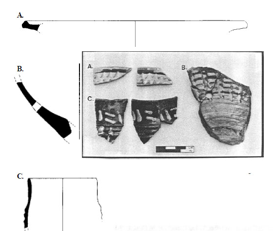 Photo 24 (above and left). European slipware fragments, with profiles.
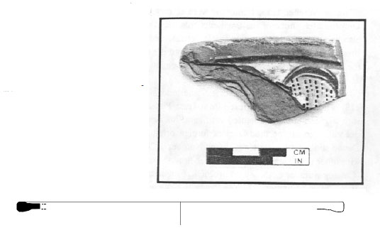 Photo 25 (below and right). North Devon slip-sgraffito dish, with profile.
132
Western Hemisphere. The late John Goggin coined the term "Itchtucknee blue on white" for this ware and he records quantities of this pottery as early as circa 1606 at Richardson, Florida and other locations in Spanish North and South America during the first half of the seventeenth century (Goggin 1968:25). Goggin also notes some fragments of this ware in the N.P.S. Jamestown Island collections which have striking parallels to the fragments found at HT55 (Goggin 1968:7980; see Photos 26-30).
Photo 25 (below and right). North Devon slip-sgraffito dish, with profile.
132
Western Hemisphere. The late John Goggin coined the term "Itchtucknee blue on white" for this ware and he records quantities of this pottery as early as circa 1606 at Richardson, Florida and other locations in Spanish North and South America during the first half of the seventeenth century (Goggin 1968:25). Goggin also notes some fragments of this ware in the N.P.S. Jamestown Island collections which have striking parallels to the fragments found at HT55 (Goggin 1968:7980; see Photos 26-30).
Site HT55 yielded fragments of Spanish costrels. The two-handled, flattened vessels (not illustrated in this report) were commonly used for beverage storage and consumption and demonstrate yet another example of the diversified nature of the ceramic assemblage found on this early site. Ivor Noël Hume excavated a number of these vessels at Martin's Hundred from contexts which date between circa 1620 and 1645, and illustrates a complete example in his published work on that excavation (I. Noël Hume 1982:52).
English Tin-Enamelled Ware
Other tin-enamelled wares include some early English tin-enamelled vessels (not illustrated) painted in a dark blue palette and stylistically similar to painted decorations found on Chinese porcelain vessels of the Wan-Li period (1573-1620) of the Ming Dynasty. Other blue-on-white painted English wares include a large and unusual jug or pitcher base (Catalog Number 1017; Photo 31) and various cylindrical drug jars (Catalog Number 1007; Photo 32).
One large English "majolica" plate (Catalog Number 1052; Photo 33) was retrieved from Trash Pit B. This vessel is enthusiastically painted in blue, green, and mustard-brown colors on a milky white background. The underside of the plate or platter is covered with a highly dimpled and nearly clear glaze which has a greenish tinge.
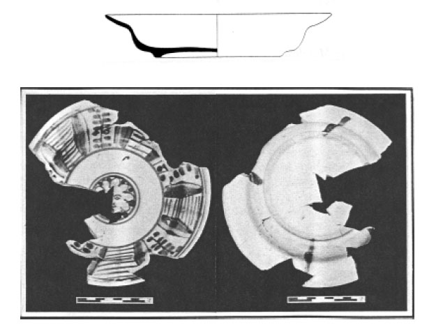 Photo 26. Portuguese/Spanish majolica plate, interior and exterior views with profile.
 Photo 27 (above). Portuguese/Spanish plate, interior and exterior views with profile.
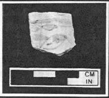 Photo 28 (left). Portuguese/Spanish majolica plate fragment from the Jamestown collection.
 Photo 29 (above). Portuguese majolica bowl, interior and exterior views with profile.
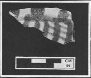 Photo 30 (right). Portuguese majolica bowl rim fragment from the Jamestown collection.
 Photo 31. English delftware jug, with profile.
 Photo 32. English delftware drug jar, with profile.
Continental Tin-Enamelled Wares
Dutch delftware, painted in polychrome colors in the Italianesque style, is also represented in the HT55 assemblage (Photo 34). This large flatware vessel (Catalog Number 1053), like the English polychrome dish mention above, is covered with a milk-white glaze upon which has been painted a centrally-positioned cherubic figure with a polychrome palette. The underside of this vessel is covered with a thinly-applied greenish glaze. Close inspection of this vessel shows a small amount of red earthenware imbedded in the nearly clear glaze within the footring. We assume that this was caused by inadvertent contact with kiln furniture during firing.
Stonewares
Site HT55 yielded relatively few stoneware vessels, all but one of which is believed to be of German origin. The "Bellarmine" or Bartmann jug found on other early seventeenth-century sites along the James River was primarily a food storage and serving vessel. The fragments of this form
136
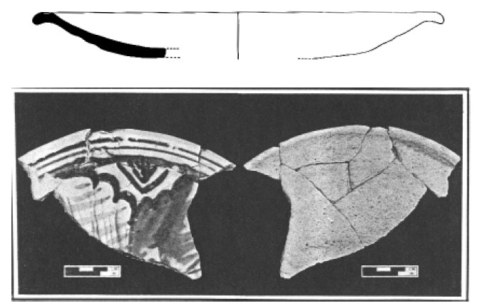 Photo 33. English delftware polychrome plate, interior and exterior views with profile.
 Photo 34. Dutch delftware dish base, interior and exterior views with profile.
137
(Catalog Number 1075; Photo 35) found in the well at Hampton University bear the typical bearded face on the neck. According to Noël Hume, the characteristics of the face become stylized and grotesque by the second quarter of seventeenth century (I. Noël Hume 1969:57). The fragment retrieved from HT55 shows some of the grotesque, stylized facial features, but retains a fluidity of line and form in the beard. A similar Frechen brown stoneware jug fragment was retrieved from the College Landing site; it has the same stylized facial features, but with a flowing beard (Pittman, in Edwards 1987:56-57).
Photo 34. Dutch delftware dish base, interior and exterior views with profile.
137
(Catalog Number 1075; Photo 35) found in the well at Hampton University bear the typical bearded face on the neck. According to Noël Hume, the characteristics of the face become stylized and grotesque by the second quarter of seventeenth century (I. Noël Hume 1969:57). The fragment retrieved from HT55 shows some of the grotesque, stylized facial features, but retains a fluidity of line and form in the beard. A similar Frechen brown stoneware jug fragment was retrieved from the College Landing site; it has the same stylized facial features, but with a flowing beard (Pittman, in Edwards 1987:56-57).
In addition to brown stonewares, HT55 contained some fragments of blue and grey Westerwald stoneware jugs of the type found by Noël Hume at Martin's Hundred. These impressively-decorated jugs (Catalog Number 1071; Photo 36) are illustrated and described in detail by Noël Hume (I. Noël Hume 1969, 1982:139). The fragments recovered from HT55 are decorated with incised lines, sprig-molded appliques, and carefully hand-painted areas. Fragments of these food storage and serving vessels have also been found at the Causey's Care site and at Jamestown.
Porcelain
Site HT55, like most other early seventeenth-century sites in the Chesapeake, yielded very few fragments of Chinese porcelain. This imported ware was initially marketed to the public by the Dutch as early as 1602 (van der Pijl-Ketel 1982:9) and was extremely popular among the wealthier purchasers of ceramic wares. As this ware did not reach Europe and consequently English North America, in large quantities until the mid-seventeenth century (van der Pijl-Ketel 1982:28), it is not surprising to find only three small fragments in discrete archaeological contexts on a site as early as HT55. The fragments were too small to make a vessel form determination, but all of the fragments are painted with the distinctive cobalt blue hand-painted decoration commonly found in the first twenty years of the seventeenth century (J. Curtis, personal communication). The presence of this expensive ware is yet another indication of the relative wealth of the early HT55 colonists.
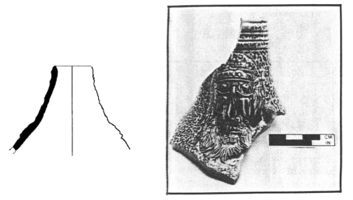 Photo 35. Bellarmine jug neck, with profile.
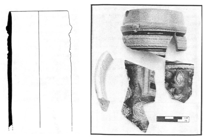 Photo 36. Westerwald blue and grey stoneware jug neck fragments, with profile.
Glass Artifacts
According to Eleanor Godfrey, "by 1640 the pattern had been laid, and the transformation of glassmaking from a medieval to a modern industry was well under way"(Godfrey 1975:256). Prior to the 1640s, glass, as well as other forms of material culture, was still tied to many medieval traditions of style and form. At the same time, because of many technical advances made in the glass industry prior to and throughout the seventeenth century, glass products in particular began to exhibit an ever-widening diversity of form and function.
As stated by Frank (1982:133), "until the beginning of the seventeenth century nearly all bottles [and containers] were made of earthenware, metal or wood." The glass assemblage at HT55, then, can be informative because it falls during the important transitional period between the wholesale use of non-glass and glass materials for storage containers. In this period, some of the glass artifacts should suggest a tie to medieval styles, such as applied string decorations, yet more "modern" forms, such as case bottles, flasks, and tablewares in colorless metal, may also be present. The presence of glass storage vessels in the HT55 assemblage indicates a transitional aspect in regard to the use of glass over ceramic or other materials. Beyond this, because the use of glass for bottles or containers was relatively new in the first half of the seventeenth century, this same transitional aspect may, in part, account for the relatively low glass fragment count for the site as a whole.
Glass Containers
Case bottles account for a significant number of storage vessels within the assemblage. For the 139 most part, case bottles were used to store and transport beverages. The seventeenth-century case bottle, was a "… common large bottle was blown into a square-sided mold and had a nearly flat base and a short neck with an everted lip, the latter feature frequently concealed beneath a threaded pewter collar and cap"(I. Noël Hume 1969:62 ). Based on stylistic attributes, these bottles were probably imported from England (I. Noël Hume 1969:70), but because of the relative thinness of their metal, they do not survive intact as well as the round or globular bottles of the second half of the century. Case bottles are helpful in establishing depositional dates because they were used prior to the round-bodied, green-glass bottles which appeared only after the beginning of the second half of the seventeenth century (I. Noël Hume 1969:62).
The artifact inventory from HT55 shows a total of 2703 fragments of case bottle composed mostly of a pale straw green metal. Of these fragments, 22 empontilled bases and 37 necks were identified. Three of these necks came from the uppermost layers of two trash pits (Trash Pits A and F), which contained intrusive material in their upper layers, probably generated by plow disturbance. These three necks were not excluded from the minimum vessel count because the nature of the features suggest that they were original components of those features. The work done by Riordan and Pogue in associating plowzone artifacts with discrete features provides the rationale for including the questionable necks (Riordan 1988; Pogue 1988). Case bottle fragments were recovered from most of the major features on the site which were proven contemporaneous by ceramic crossmends. As there were more necks than bases, the larger quantity was used to establish the minimum vessel count for the site.
Window Glass
Sixteen fragments of window glass were found at the Hampton University site. While window glass fragments were a significant portion of the glass assemblage, they were not used for interpreting occupational dates for the site. Since "the process [for making window glass] changed little over the centuries so it is not generally possible to come to conclusions about age…"(Frank 1982:142) . First imported to the colonies in the 1620s (Wilson 1976:152), the presence of window glass as an architectural element in early seventeenth-century colonial Virginia is a good indicator of wealth or status.
The use of casement windows in the seventeenth century had its origins in medieval architecture (Wilson 1976:156). Indeed, the concept of earthfast construction techniques which were used at the Hampton University site has its origin in Anglo-Saxon and Medieval England (Carson et al. 1981:136). As has been ably described by Carson et al. (1981), the earthfast structures that grew out of this European building tradition were not temporary structures, but were obviously intended for long-term habitation. According to Carson et al. (1981:139-140), "whether they came to farm, to trade, or to follow some other occupation, immigrants expected to make an investment in buildings."
The addition of imported window glass, lathe-marked plaster (Catalog Number 5001; see Photo 44), and roofing tiles (Catalog Number 1240 and 1241; see Photo 45) to these earthfast structures speaks of an uncommon affluence of the HT55 residents in the early years of colonization.
The window pane fragments excavated from the site may be described using terminology derived from Richard Neve's Builder's Dictionary of 1736. In this work, diamond-shaped panes with an overall length of 6 inches, maximum width of 4.8 inches, and having an acute angle of 77 degrees and an obtuse angle of 102 degrees are identified as a "square quarrel." The analysis of the HT55 window pane fragments yielded two fragments with sufficiently well-defined cut edges whose angles closely match the square quarrel angle measurements (see Figure 43). Additionally, one fragment, in the form of an isosceles triangle,
perfectly fits within Neve's dimensions for
140
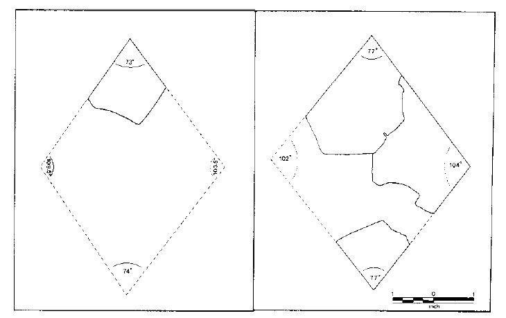 Figure 43. Window pane angles.
a square quarrel with an obtuse angle of 104 degrees. This "half square quarrel"1 may have been used along the edge of the casement window to square off the sides. Two other smaller fragments with relatively well-defined edges and measurable angles of 74 degrees each do not comfortably fit within Neve's prescribed measurements, but the deterioration of the metal along the edges may account for this discrepancy.
Figure 43. Window pane angles.
a square quarrel with an obtuse angle of 104 degrees. This "half square quarrel"1 may have been used along the edge of the casement window to square off the sides. Two other smaller fragments with relatively well-defined edges and measurable angles of 74 degrees each do not comfortably fit within Neve's prescribed measurements, but the deterioration of the metal along the edges may account for this discrepancy.
Although 16 fragments of window glass would not be sufficient to make even one small window, these fragments in association with 24 fragments of window leading confirm the presence of these architectural features. One of the fragments of window glass (Catalog Number 260), a small equilateral triangle of glass measuring approximately one and three-quarters inch on each side, was completely encircled by its original turned-lead trim. The recent discovery of dates and other inscriptions inside turned window leads by Noël Hume and subsequent work by such researchers as Susan Hanna et al. have proven a means of applying dates after which these architectural elements were assembled (I. Noël Hume 1982; Hanna 1986:303-309). Because the dates of the inscriptions found in drawn window leads were imparted by a removable element of the glazier's vice, which may have been used over a long period of time, archaeologists must use caution when applying these dates to the buildings that they excavate. All of the drawn lead fragments from HT55 which have undergone conservation have been clean and, unfortunately, show no inscriptions of any kind.
Mirror Glass
Seven colorless, thin, flat fragments of glass were retrieved from various layers within the well. Al 141 though they have not retained any evidence of silvering, these fragments have been identified as mirror glass. Mirror glass was "a highly prized luxury" in the late sixteenth century (Godfrey 1975:236), and a relatively expensive and valued object for an early seventeenth-century colonial site. Thus a mirror or mirror glass found at HT55 would be the type of artifact indicative of wealth or high status.
Luxury Table Glass
Ten pieces of container glass, six colored and four colorless non-leaded fragments, were found during the course of excavation. Of the colorless, non-leaded fragments, one piece of polychrome enamelled glass and one piece with trailed decoration were identified (Catalog Number 193; see Photo 37). Additionally, one notable piece of dark green container glass (Catalog Number 5000) from Trash Pit F is remarkably similar to a base fragment of a drinking glass similar to one illustrated by Robert Charleston in his book, English Glass (Charleston 1984:44; Figure 44). The fragment exhibits marks of abrasion on the standing surface of the folded foot, as well as surface dimpling in the metal, which is indicative of tool manipulation during manufacture. The presence of this somewhat specialized vessel form in the assemblage is in marked contrast to the more commonplace case bottles.
Thirty-five pieces of table glass, nine colored pieces and twenty-six pieces of colorless non-lead glass were identified. Three of the fragments of colored glass were decorated with applied horizontal strings of the same color metal and appear to be similar to a sixteenth-century green glass goblet illustrated in "A Restoration Glass Hoard From Gracechurch St., London" (Oswald and Phillips 1949:30). Three other fragments of colorless, non-lead glass also had applied decoration. In this case, strings of opaque white glass had been vertically applied to the metal. Three small handle fragments of a dark black-green metal from unidentified vessel forms were also associated with this group.
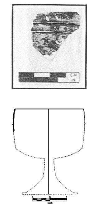 Photo 37. String-trailed glass container fragment, with profile on projected vessel form.
Stemmed glassware was also represented in the assemblage. Most notable among these was one complete free blown base and stem made of a pale greenish-blue metal. This base (Catalog Number 036) exhibits a rather clumsily folded foot, a welded stem with a single ball-shaped knop (see Photo 38). A striking parallel to this folded foot and stem, like the drinking glass base
142
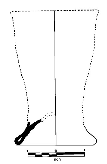 Figure 44. Drinking beaker foot fragment on projected vessel form.
fragment mentioned above, is illustrated by Robert Charleston and is attributed to Gracechurch Street, London and is dated about 1600 (Charleston 1984:Plate 19d).
Figure 44. Drinking beaker foot fragment on projected vessel form.
fragment mentioned above, is illustrated by Robert Charleston and is attributed to Gracechurch Street, London and is dated about 1600 (Charleston 1984:Plate 19d).
One other fragment of stemmed glassware in a colorless, non-leaded metal was retrieved. This fragment bears all of the characteristic crizzling and decomposition typical of excavated European or early English "cristallo" and is a fragment of a funnel-shaped solid knop. This piece of "luxury glass" (Charleston 1984:43) is important because it speaks of a level of affluence unexpected in early colonial Virginia. Furthermore, the cristallo is deeply rooted in the medieval tradition of glassmaking (Charleston 1984:45).
A diminutive fragment of a folded foot made of colorless non-leaded metal was also identified. It is uncertain from which vessel form this fragment comes; however, the delicate turning of the foot, the thinness of the metal, and the relatively small size of the form were unique among the glass assemblage at HT55. Finally, three fragments of colorless, nonleaded metal were retrieved from the well. Two of these fragments mend, and the third is non-contiguous. They are thought to be fragments of a wine glass stem of the type known as a "cigar-stem." A remarkably similar wine glass, documented by Robert Charleston, was attributed to the first half of the seventeenth century (Charleston 1984:Plate 15a).
A total of five fragments of thin blue glass were retrieved from Trash Pit A. These fragments, which do not crossmend, are remarkable for their thinness and distinctive color. Ivor Noël Hume suggests that they appear to be fragments from a French drinking goblet of cylindrical form with ball feet (I. Noël Hume, personal communication).
Utilitarian Glass
The handle of a linen smoother (Catalog Number 035) was retrieved from a post mold associated with Structure B (Photo 39). This specialized textile-related tool is discussed by Charleston and is found on English and Scandinavian sites as early as the thirteenth century (Charleston 1984:3738).
Tobacco Pipes
A total of 1883 fragmentary tobacco pipe bowls and stems of domestic and foreign origin was retrieved from HT55. Of these, 1311 bowl and stem fragments were considered to be of Dutch or English manufacture, and 572 bowl and stem fragments
were designated domestic in origin. The criteria used for determining the origin of these pipe fragments were based solely on the visual characteristics of the clay body (that is, color, hardness, and texture), bowl shape, impressed or applied decoration, apparent manufacturing method, and presence of maker's marks. Those examples were clearly made of white-firing clay and showed evidence of having been mold
143
 Photo 38. Stemmed wine glass base, with profile.
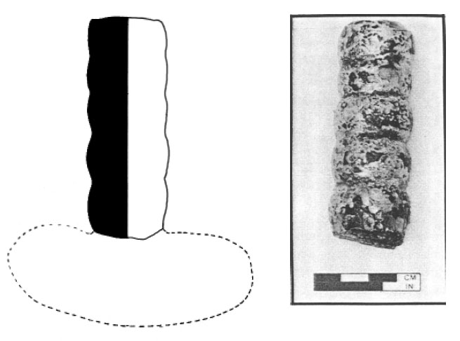 Photo 39. Glass linen smoother handle, with profile on projected form.
144
formed and bearing maker's marks, and thus were classified as imported. Similarly, those fragments which were composed of a fine-grained pale brownish-red clay were classified as domestic. The term "terra cotta" (Henry 1976; Crass et 1988) has been extensively used by other researchers of domestically-produced tobacco pipes; but, it is felt that this term is not the best
description of the clay bodies used in the manufacture of these pipes. The term "domestic" is used in the present study to differentiate these pipes from their imported counterparts.
Photo 39. Glass linen smoother handle, with profile on projected form.
144
formed and bearing maker's marks, and thus were classified as imported. Similarly, those fragments which were composed of a fine-grained pale brownish-red clay were classified as domestic. The term "terra cotta" (Henry 1976; Crass et 1988) has been extensively used by other researchers of domestically-produced tobacco pipes; but, it is felt that this term is not the best
description of the clay bodies used in the manufacture of these pipes. The term "domestic" is used in the present study to differentiate these pipes from their imported counterparts.
The following table (Table 24) illustrates the breakdown of the major pipe categories, separating the bowls and stems by origin, pipe element, rudimentary decoration—including both incised or molded motifs—and the presence or absence of maker's marks.
A rudimentary comparison of the quantities of imported pipes and bowls to those of domestic manufacture shows a preponderance of imported tobacco fragments. Of the total number of fragments, 69.6% were imported and 30.4% were of domestic origin. A further breakdown of basic percentages reveals that of the total 1311 imported fragments, less than one third (23.2%) of the fragments were bowl sherds, and 76.8% fragments were stems. For the domestic pipe fragments, a similar percentage of bowl to stem fragments existed; 61.2% of the fragments were stems, and 38.2% bowls.
| IMPORTED BOWLS: | |
|---|---|
| Plain and/or simple rouletted decoration | 237 |
| As above with maker's mark | 4 |
| Decorated | 6 |
| Decorated, with maker's mark | 57 |
| Subtotal of Imported Bowls | 304 |
| IMPORTED STEMS: | |
| Plain and/or simple rouletted decoration | 976 |
| Decorated | 31 |
| Subtotal of Imported Stems | 1007 |
| Subtotal of Imported Bowls and Stems | 1311 |
| DOMESTIC BOWLS: | |
| Plain and/or simple rouletted decoration | 194 |
| As above with maker's mark | 1 |
| Decorated | 23 |
| Decorated, with maker's mark | 4 |
| Subtotal of Domestic Bowls | 222 |
| DOMESTIC STEMS: | |
| Plain and/or simple rouletted decoration | 337 |
| Decorated | 13 |
| Subtotal of Domestic Stems | 350 |
| Subtotal of Domestic Bowls and Stems | 572 |
| GRAND TOTAL OF ALL TOBACCO BOWLS AND STEMS | 1883 |
Harrington/Binford Stem-Hole
Diameter Analysis
A sample of 649 tobacco pipe stems from HT55 were subjected to the standard analytical procedures devised by J.C. Harrington and Lewis Binford, in order to determine a suggested date range of occupation (Harrington 1954, 1978) and a calculated mean date of occupation (Binford 1978). The pioneering work done by these two scholars has proven useful to many historical archaeologists who have excavated seventeenth-and eighteenth-century sites throughout the eastern United States, particularly along the James River. James Deetz used the Harrington method to convincingly define the shifting settlement patterns which existed at Flowerdew Hundred during its long period of occupation (Deetz 1987). In the same manner, the combined Harrington and Binford dating techniques were utilized in the analysis of HT55 tobacco stems to suggest temporal co-existence between the major features on the site and to indicate the range of occupation of the site as a whole.
As can be seen in the calculations and graphs below, the results of these computations suggest a Harrington range of occupation of the entire site predominantly in the period 1620 to 1650 (Table 25; Figure 45), gradually tapering off in the period 1650-1680. As the significant concentration occurs in the earlier period, it may be deduced that the heaviest occupation of the site was between 1620 and 1650. The calculations based on the Binford straight line regression formula provide a mean date of 1639. In this case, the two techniques would seem to agree and support the dating of the site which is indicated by the ceramic assemblage.
The Harrington computations for the five major features of the site including the well, and four trash pits, follow a similar pattern indicating a predominant occupation range between 1620 and 1650, with the exception of Trash Pit F which falls later in the 1650 to 1680 period (Figure 46). The Binford mean date for Trash Pit F is 1651, which does not fall near the midpoint of the date range, 1665, provided by the Harrington method. In this case, the two techniques would seem to disagree. This late deposition suggests that HT55 may have been occupied or at least used for trash disposal as late as the third quarter of the seventeenth century.
The statistical date for Trash Pit A is 1637, which exactly coincides with the calculated date for the well. This is not surprising in light of the fact that these two features were proven to be temporally related by a ceramic crossmend (Catalog Number 1143).
The quantities of tobacco pipe stems from the trash pits designated as Trash Pits A and F (40 and 36 pipe stems, respectively), were initially considered too small to yield reliable results from Harrington calculations (see Figure 48). However, the results from this analysis yielded two entirely different mean dates of 1651 for Trash Pit F and 1630 for Trash Pit H. Because these features were in very close proximity, and during excavation had been perceived as being related, they provided an opportunity to indicate the terminal point of occupation or trash disposal on this site. The variance of 21.5 years between the two features suggests two separate periods of deposition and further suggests that the occupation of the site extended into the third quarter of the seventeenth century.
The Harrington histograms for Trash Pits F and H indicate opposing trends between the two features. The date range for Trash Pit H falls into the 1620 to 1650 period, while Trash Pit F falls even later into the 1650 to 1680 period. When the two are combined, a bi-modal frequency appears to span the period from 1620 to 1680. The fact that there were no ceramic crossmends between these two closely positioned features strongly suggests that they were filled at separate times.
Imported and Marked Pipe Bowls
Table 26 shows the marked imported bowls and their provenience and suggested origin. The reader will note that this space is inadequate to fully 146
| ENTIRE SITE: | ||
|---|---|---|
| Diameter | Quantity | Product |
| 5/64" | 1 | 5 |
| 6/64" | 37 | 222 |
| 7/64" | 228 | 1,596 |
| 8/64" | 320 | 2,560 |
| 9/64" | 60 | 540 |
| 10/64" | 2 | 20 |
| 11/64"* | +1 | +11 |
| 649 | 4,954 | |
| 4,954 | ||
| 649 = 7.633 x 38.26 = 292.038 | ||
| 1931.85 - 292.038 = 1639.812 | ||
| WELL (Figure 47): | ||
| Diameter | Quantity | Product |
| 5/64" | 0 | 0 |
| 6/64" | 9 | 54 |
| 7/64" | 46 | 322 |
| 8/64" | 54 | 432 |
| 9/64" | 21 | 189 |
| 10/64" | 2 | 20 |
| 11/64" | +0 | +0 |
| 132 | 1,017 | |
| 1,017 | ||
| 132 = 7.704 x 38.26 = 294.755 | ||
| 1931.85 - 294.755 = 1637.095 | ||
| TRASH PIT B: | ||
| Diameter | Quantity | Product |
| 5/64" | 0 | 0 |
| 6/64" | 13 | 78 |
| 7/64" | 79 | 553 |
| 8/64" | 116 | 928 |
| 9/64" | 11 | 99 |
| 10/64" | 0 | 0 |
| 11/64" | +0 | +0 |
| 219 | 1,658 | |
| 1,658 | ||
| 219 = 7.570 x 38.26 = 289.657 | ||
| 1931.85 - 289.657 = 1642.193 | ||
| 147 | ||
| TRASH PIT A: | ||
| Diameter | Quantity | Product |
| 5/64" | 0 | 0 |
| 6/64" | 1 | 6 |
| 7/64" | 8 | 56 |
| 8/64" | 16 | 128 |
| 9/64" | 2 | 18 |
| 10/64" | 0 | 0 |
| 11/64" | +0 | +0 |
| 27 | 208 | |
| 208 | ||
| 27 = 7.703 x 38.26 = 294.743 | ||
| 1931.85 - 294.743 = 1637.107 | ||
| COMBINED TRASH PITS F and H: | ||
| Diameter | Quantity | Product |
| 5/64" | 0 | 0 |
| 6/64" | 5 | 30 |
| 7/64" | 31 | 217 |
| 8/64" | 31 | 248 |
| 9/64" | 8 | 72 |
| 10/64" | 1 | 10 |
| 11/64" | +0 | +0 |
| 76 | 577 | |
| 577 | ||
| 76 = 7.592 x 38.26 = 290.473 | ||
| 1931.85 - 290.473 = 1641.377 | ||
| TRASH PIT F: | ||
| Diameter | Quantity | Product |
| 5/64" | 0 | 0 |
| 6/64" | 5 | 30 |
| 7/64" | 22 | 154 |
| 8/64" | 9 | 72 |
| 9/64" | 3 | 27 |
| 10/64" | 1 | 10 |
| 11/64" | +0 | +0 |
| 40 | 293 | |
| 293 | ||
| 40 =7.325 x 38.26 = 280.254 | ||
| 1931.85 - 280.254 = 1651.596 | ||
| 148 | ||
| TRASH PIT H: | ||
| Diameter | Quantity | Product |
| 5/64" | 0 | 0 |
| 6/64" | 0 | 0 |
| 7/64" | 9 | 63 |
| 8/64" | 22 | 176 |
| 9/64" | 5 | 45 |
| 10/64" | 0 | 0 |
| 11/64" | +0 | +0 |
| 36 | 284 | |
| 284 | ||
| 36 = 7.888 x 38.26 = 301.828 | ||
| 1931.85 - 301.002 = 1630.022 | ||
 Figure 45. Harrington histogram—entire site.
 Figure 46. Harrington histogram—site by feature.
describe the marks, and reference should be made to the more detailed descriptions of the cataloged pipe bowls in the following pages. Additionally, the suggested dates indicated for each of the marked pipe bowls are taken from some of the
published research done on seventeenth century tobacco pipes by such authorities as Iain Walker, Adrian Oswald, and Ivor and Audrey Noël Hume. They are included in this listing only to provide the reader with a broad frame of reference for
depositional dating and documentation where these marked pipes appear on other archaeological sites. Therefore these dates should not be confused with the dating of features at HT55.
Figure 46. Harrington histogram—site by feature.
describe the marks, and reference should be made to the more detailed descriptions of the cataloged pipe bowls in the following pages. Additionally, the suggested dates indicated for each of the marked pipe bowls are taken from some of the
published research done on seventeenth century tobacco pipes by such authorities as Iain Walker, Adrian Oswald, and Ivor and Audrey Noël Hume. They are included in this listing only to provide the reader with a broad frame of reference for
depositional dating and documentation where these marked pipes appear on other archaeological sites. Therefore these dates should not be confused with the dating of features at HT55.
Of the 53 marked pipe bowls, 10 (18.8%) are thought to be of English manufacture; 30 (56.6%) are thought to be Dutch, and the remaining 13 (24.5%) are of unknown origin (Figure 49).
The highest concentration of marked pipe bowls occurred in Trash Pit B, which is a large trash pit located just north of Structure A (Figure 50). This feature held 16 marked bowls—the majority being of Dutch origin. The deposition of
149
 Figure 47. Harrington histograms—Well, Trash Pit A, and Trash Pit B.
tobacco pipe fragments and other domestic refuse in this large feature located so near Structure A suggests the nature of trash disposal practiced by the inhabitants of the property either during the course of occupation or at the termination of residence.
It is not surprising to note that four pipes with the same mark of "W C" were found in this trash pit and in a posthole of Structure A (Catalog Numbers 6117, 6119, 6121, and 6123). This mark has been attributed to the English pipemaker William Collins (Oswald 1970:138). Even though the maker's marks found on tobacco pipes are not always the best indicators of date of manufacture, this mark can at least provide a date before which deposition of refuse in the pit and the construction of Structure A could have taken place. Numerous examples of this mark have appeared on sites throughout the James River Basin with depositional dates ranging from circa 1620 to 1660 and are discussed below in the descriptive catalog of tobacco pipes.
Figure 47. Harrington histograms—Well, Trash Pit A, and Trash Pit B.
tobacco pipe fragments and other domestic refuse in this large feature located so near Structure A suggests the nature of trash disposal practiced by the inhabitants of the property either during the course of occupation or at the termination of residence.
It is not surprising to note that four pipes with the same mark of "W C" were found in this trash pit and in a posthole of Structure A (Catalog Numbers 6117, 6119, 6121, and 6123). This mark has been attributed to the English pipemaker William Collins (Oswald 1970:138). Even though the maker's marks found on tobacco pipes are not always the best indicators of date of manufacture, this mark can at least provide a date before which deposition of refuse in the pit and the construction of Structure A could have taken place. Numerous examples of this mark have appeared on sites throughout the James River Basin with depositional dates ranging from circa 1620 to 1660 and are discussed below in the descriptive catalog of tobacco pipes.
The well held 10 marked bowls, but unfortunately only two could be associated with Dutch manufacture, one with English, and the majority
150
 Figure 48. Harrington histograms—Trash Pit F, Trash Pit H, and Trash Pits F and H combined.
(7) of unknown origin. The well also contained large quantities of domestic refuse and may have been filled at or about the same time as the large Trash Pits A and B north of the major structures on the site. Unfortunately, no ceramic crossmends were found to prove a contemporaneous relationship between Trash Pit B and the well; however, a crossmend in a locally-made coarse earthenware vessel (Catalog Number 1143) was found to prove the temporal association of Trash Pit A with the well.
Figure 48. Harrington histograms—Trash Pit F, Trash Pit H, and Trash Pits F and H combined.
(7) of unknown origin. The well also contained large quantities of domestic refuse and may have been filled at or about the same time as the large Trash Pits A and B north of the major structures on the site. Unfortunately, no ceramic crossmends were found to prove a contemporaneous relationship between Trash Pit B and the well; however, a crossmend in a locally-made coarse earthenware vessel (Catalog Number 1143) was found to prove the temporal association of Trash Pit A with the well.
Trash Pits G and H each contained six marked bowls. Four in each pit were of Dutch origin, while the remainder were of unknown manufacture. Trash Pit F contained only four marked pipe bowls, all suspected of being Dutch in origin. The association of Trash Pits F and G is suggested but not proven by the presence of pipe bowls with the same maker's mark, "S H," in each and also by a non-contiguous ceramic fragment association in an English delftware jug (Catalog Number 1017). Dutch tobacco pipes with this mark
have been found on other sites with depositional
151
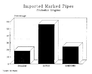 Figure 49. Imported marked pipes—probable origin.
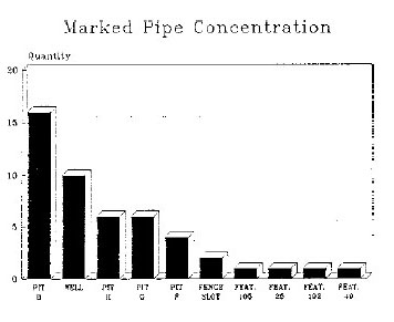 Figure 50. Marked pipe concentrations.
dates prior to 1650 (A. Noël Hume 1979:2526; Oswald 1969:140).
Figure 50. Marked pipe concentrations.
dates prior to 1650 (A. Noël Hume 1979:2526; Oswald 1969:140).
Capacity Study of Tobacco Pipe Bowls
The capacity of some of the imported and domestic tobacco pipe bowls from the HT55 was recorded using aluminum oxide crystals of the type used in airbrasive conservation equipment. This substance was chosen because the microscopic crystals are fairly regular in size, measuring no more than 50 microns in diameter, and because this powder has a low compression factor, thus insuring greater consistency in the measurements of weight. The stem holes at the bases of the bowls were plugged to prevent any of the powder from entering the stem and compromising the measurements. The capacities of the sample pipe bowls are calculated based on the assumption that a rigid container with the internal measurements of 2.32 cm by 2.32 cm by 0.48 cm deep contains 2.58 cubic centimeters. This container was completely filled with the same aluminum oxide powder that was used to measure the pipe bowls. The powder contents of this container weighted 3.7 grams. The calculations for cubic displacement of the bowls were then made using the following basic ratio formula:
| 3.7 grams | grams of powder in bowl | |
| x | ||
| 2.58 cm3 | X |
A random sample of 20 white-clay pipe bowls was selected to be compared with a similar group of domestic pipe bowls in the hopes of finding some correlation between the sizes. It was impossible to perform this same comparison between pipes of English and Dutch origin because of the measurable and marked HT55 pipe bowls, only three were identified as possibly English in origin, as opposed to 18 Dutch bowls. The obvious imbalance in the quantities of examples would have biased the averages and made any other calculations meaningless.
The average bowl capacity of the white-clay sample was 2.64 cm3, while the average capacity of the domestic clay bowls was 4.30 cm3. This amounts to approximately 61.4% greater capacity for the domestic pipes over that of imported examples (Figure 51). This variance can possibly be explained in part by the methods of construction of the two types of pipes. The imported pipes were invariably molded, while a significant proportion of the domestic pipes were hand-formed 152
| Catalog Number | Maker's Mark | Type of Context | Possible Origin | Suggested Date Range |
|---|---|---|---|---|
| 6110 | "I B" | Trash Pit G | Unknown | 1620-1650 |
| 6111 | "M B" | Well | English | 1650-1680 |
| 6112 | "B C" | Slot Fence | Dutch | 1620-1660 |
| 6113 | "B C" | Trash Pit F | Dutch | 1620-1660 |
| 6114 | B C" | Trash Pit F | Dutch | 1620-1660 |
| 6115 | "B C" | Trash Pit H | Dutch | 1620-1660 |
| 6176 | "B C" | Trash Pit H | Dutch | 1620-1660 |
| 6116 | "B C" | Trash Pit B | Dutch | 1620-1660 |
| 6117 | "W C" | Trash Pit B | English | 1640-1660 |
| 6118 | "W C" | Feature 105 | English | 1640-1660 |
| 6119 | "W C" | Trash Pit B | English | 1640-1660 |
| 6120 | "W C" | Trash Pit A | English | 1640-1660 |
| 6121 | "W C" | Trash Pit B | English | 1640-1660 |
| 6122 | "W C" | Feature 25 | English | 1640-1660 |
| 6123 | "W C" | Structure A | English | 1640-1660 |
| 6124 | "W C" | Slot Fence | English | 1640-1660 |
| 6125 | "C D" | Well | Unknown | Unknown |
| 6126 | "I (?) D" | Well | Unknown | Unknown |
| 6127 | "W D" | Trash Pit G | Unknown | Unknown |
| 6128 | "H F" | Slot Fence | Dutch | Circa 1640 |
| 6129 | "H F" | Trash Pit G | Dutch | Circa 1640 |
| 6188 | "H F" | Trash Pit H | Dutch | Circa 1640 |
| 6130 | "H F" | Trash Pit A | Dutch | Circa 1640 |
| 6131 | "I (?) H" | Trash Pit A | Unknown | Unknown |
| 6132 | "S H" | Trash Pit B | Dutch | Pre-1650 |
| 6133 | "S H" | Trash Pit F | Dutch | Pre-1650 |
| 6160 | "S H" | Trash Pit F | Dutch | Pre-1650 |
| 6134 | "S H" | Trash Pit B | Dutch | Pre-1650 |
| 6135 | "S H" | Trash Pit G | Dutch | Pre-1650 |
| 6136 | "I P" | Feature 192 | English | 1620-1660 |
| 6137 | "AOR" | Well | Dutch | 1624-1676 |
| 6138 | "W R" | Trash Pit B | Dutch | 1624-1676 |
| 6139 | "W R" | Trash Pit B | Dutch | 1624-1676 |
| 6140 | "W R" | Trash Pit B | Dutch | 1624-1676 |
| 6141 | "A S | Well | Unknown | 1624-1676 |
| 6142 | "H S" | Trash Pit H | Unknown | 1624-1676 |
| 6143 | Tudor rose | Trash Pit H | Dutch | Pre-1650 |
| 6144 | Tudor rose | Trash Pit B | Dutch | Pre-1650 |
| 6145 | "W P" | Feature 49 | Dutch | Unknown |
| 6146 | Crowned heart | Trash Pit B | Dutch | Pre-1640 |
| 6147 | Crowned heart | Trash Pit B | Dutch | Pre-1640 |
| 6148 | Fleur-de-lis | Trash Pit B | Dutch | Unknown |
| 6149 | Fleur-de-lis | Trash Pit B | Dutch | Unknown |
| 6150 | Fleur-de-lis/heart | Trash Pit H | Dutch | Unknown |
| 6151 | Fleur-de-lis/blossom | Trash Pit B | Unknown | Unknown |
| 153 | ||||
| 6152 | Fleur-de-lis/blossom | Trash Pit B | Unknown | Unknown |
| 6153 | Eglantine? | Trash Pit H | Unknown | Unknown |
| 6154 | Indiscernible | Well | Unknown | Unknown |
| 6155 | "E?I" | Well | Unknown | Unknown |
| 6156 | "FRM" | Trash Pit G | Dutch | Unknown |
| 6157 | "? B" | Well | English | Unknown |
| 6158 | Indiscernible | Well | Unknown | Unknown |
| 6159 | Fleur-de-lis | Well | Dutch | Unknown |
Contemporaneous Relationships Established Through Crossmending
The white clay tobacco pipes from HT55 were crossmended, yielding two contemporaneous relationships between macro-features. A small trash pit (Trash Pit E) and the well were proven contemporaneous by a single crossmend in a pipe bowl (Catalog Number 6102). A crossmend between two fragments of a plain tobacco pipe stem (Catalog Number 6106) proves a relationship between Trash Pits G and H.
Domestic Tobacco Pipes
The study of domestically-produced clay tobacco pipes has occupied the attention of a number of material culture scholars in the recent past. These
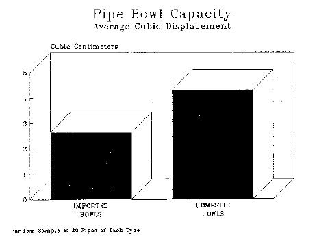 Figure 51. Pipe bowl capacity.
artifacts have been used to help fill a void of knowledge relating to economics, tobacco consumption patterns, manufacturing techniques of locally-made and imported pipes, and the cultural backgrounds which are evident in the forms and decorations used by early settlers in the Chesapeake. One of the earliest works was that of Susan Henry, who studied the pipes retrieved from various features at Saint Mary's City, Maryland, intending to show a correlation between the fluctuations in the tobacco-based economy and the frequency of these domestic pipes. Henry also attempted to describe the stylistic variation in the incised decoration appearing on the pipes and to establish a dating framework, based on association with dated contexts (Henry 1976). The
154
dating scheme set forth by Henry was called into question by the recent excavations at the College Landing site, conducted by the Department of Archaeological Research in 1987. In the course of these excavations, a large borrow pit feature was excavated, revealing an assemblage of locally-made tobacco pipes with a full range of decorative aspects that Henry had previously assigned
to various periods in the seventeenth century. The borrow pit feature was shown to have been open only for a short period of time, as ceramic crossmends were established from the uppermost layers to the bottom layers, suggesting a single episode of filling, or at least filling over a short period of time (Edwards 1987). The retrieval of so many domestic pipes from one short-lived feature dating no later than 1650 calls into question the assumptions made by Henry in dealing with the dating of these pipes based on stylistic considerations.
Figure 51. Pipe bowl capacity.
artifacts have been used to help fill a void of knowledge relating to economics, tobacco consumption patterns, manufacturing techniques of locally-made and imported pipes, and the cultural backgrounds which are evident in the forms and decorations used by early settlers in the Chesapeake. One of the earliest works was that of Susan Henry, who studied the pipes retrieved from various features at Saint Mary's City, Maryland, intending to show a correlation between the fluctuations in the tobacco-based economy and the frequency of these domestic pipes. Henry also attempted to describe the stylistic variation in the incised decoration appearing on the pipes and to establish a dating framework, based on association with dated contexts (Henry 1976). The
154
dating scheme set forth by Henry was called into question by the recent excavations at the College Landing site, conducted by the Department of Archaeological Research in 1987. In the course of these excavations, a large borrow pit feature was excavated, revealing an assemblage of locally-made tobacco pipes with a full range of decorative aspects that Henry had previously assigned
to various periods in the seventeenth century. The borrow pit feature was shown to have been open only for a short period of time, as ceramic crossmends were established from the uppermost layers to the bottom layers, suggesting a single episode of filling, or at least filling over a short period of time (Edwards 1987). The retrieval of so many domestic pipes from one short-lived feature dating no later than 1650 calls into question the assumptions made by Henry in dealing with the dating of these pipes based on stylistic considerations.
The College Landing pipes that were studied by Lester and Hendricks (1987) were grouped into stylistic categories based on bowl shape and incised decoration. Their conclusions show that there was a multitude of domestic tobacco pipe shapes and decorative motifs in use simultaneously during the first half of the seventeenth century (Lester and Hendricks 1987). These authors suggest that the domestic tobacco pipes were the product of a mixture of European and aboriginal culture. Later work in the subject has shown a strong indication of West African influences in the incised decoration. Mathew Emerson's recent work on domestic tobacco pipes Emerson 1988) contradicts Susan Henry's earlier explanations of the factors which motivated local pipe production. Henry's assumption was that domestic pipes were locally produced as a plantation industry in response to a depressed tobacco economy when imported goods were not as readily available (Henry 1979). Emerson's contention is that these domestically produced pipes are a phenomenon of the second half of the seventeenth century and were produced not by the larger planters but by the "… people who were landless, bonded, and without any access to even the most inexpensive imported commodities"(Emerson 1988:168) . Emerson proceeds to argue that "… the manufacture of local pipes by servants on English plantations to fill their own needs is the most plausible pipemaking context in the Chesapeake" (Emerson 1988:169). Emerson then contends that the increase in the number of African slaves in the Chesapeake after the middle of the seventeenth century accounts for the stylistic parallels between West African artistic motifs and the incised decoration on domestically-produced pipes, constituting "… the first physical evidence of slaves in the Chesapeake"(Emerson 1988:171) .
Emerson's theory ignores, however, the presence of domestic tobacco pipes retrieved from such sites as College Landing and HT55, which are firmly dated in the first half of the seventeenth century. As the first indentured blacks were transported to Virginia by the Dutch in 1619, and their numbers did not exceed 2% of the total population until after 1650 (Jordan 1978:148; Ver Steeg 1964:60-61), it seems extremely unlikely that so small a portion of the population could have produced an artifact which occurs in such large numbers in widely-dispersed settlements along the navigable James River during the first half of the seventeenth century. Clearly, some other cultural force must have come into play in the decades before there was a significant black presence in the Virginia Colony in order to bring about the distinctive decorations and shapes found on domestically-produced tobacco pipes. The most likely possibility lies in the interaction between the landless Caucasian population and the indigenous Native Americans. English servants, who constituted the majority of the work force in the first three quarters of the seventeenth century (Horn 1979:51; Davis 1986:4-8), may have learned the traditional methods of hand-making clay tobacco pipes from the remaining indigenous Native Americans, copying their shapes and decorative motifs. After the second half of the seventeenth century, as the Native American peoples were being displaced by steadily-increasing English population and more extensive cultivation of land for tobacco production occurred, the influence 155 of the aboriginal culture was gradually replaced with that of the African servant or slave.
The domestic tobacco pipes that were retrieved from HT55 were compared with those excavated at the College Landing site, and appear very similar in character (Lester and Hendricks 1987). The range of decorative motifs and bowl shapes evident in the assemblage is also similar to the motifs and shapes discussed by Emerson from various locations throughout the Chesapeake (Emerson 1988). In the detailed catalog of domestic pipes which follows, occasional reference is made to typologies set forth by Emerson, Crass, and others (Emerson 1988; Crass 1988; Lester and Hendricks 1987; Henry 1979). However, it was discovered early in the study that these typologies are too general to be of definitive value in the classification of bowl shapes. The decorative classifications assigned by Emerson were equally general and do not adequately cover the range of decorations found in the HT55 assemblage.
Other Artifacts
The author regrets the lack of complete photographic illustration of the objects under discussion in this section of the report. The conservation treatment of the vast majority of the metal and organic artifacts had not been completed at the time of this writing. It was therefore impossible to provide the same level and quality of photographic documentation for these objects and at the same time meet the designated report completion date. Pre-treatment conservation photographs and drawings of the objects submitted for conservation treatment were made and are available for inspection and comparative study.
The non-ceramic and non-glass artifacts recovered from HT55 provided some unique insights into the quality of life enjoyed by early Virginia settlers (Table 27). The diversity and range of non-ceramic artifacts found on the site may be useful in suggesting activities areas and functions of the various major structures and related features. In light of the suspected, but not proven, ecclesiastic association with the Parish of Kicoughtan, this functional/locational analysis may prove useful in understanding the land-use practices of the inhabitants of the site. For ease in systematically addressing this body of material the finds were divided into ten functional categories, including: Non-Ceramic Food Preparation and Consumption, Cutlery, Tools and Equipment, Weaponry and Armor, Personal Items, Textile Related, Trade Related, Furniture Related, Architectural, and Nails. Even though cutlery items are technically associated with both food consumption and preparation, it was decided to separate these tableware items from the other food-related objects because of the large quantity of knives. It is felt that a distribution of these cutlery items in comparison to the other foodways objects may be revealing.
Operating on the long-established premise that concentrations of artifacts on a site may indicate areas of specialized activity, the finds were analyzed to suggest possible craft activities, trash disposal practices, and possible functions of the major structures (Beck et al. 1983; Stewart-Abernathy 1986; King 1988).
It is evident from the distribution, that the majority of food preparation and consumption objects were retrieved from the well, which is located on the west side of the site. These objects appear to be metal drinking cups and cooking pot fragments.
A similar pattern is evident in the distribution of cutlery objects as in the food preparation and consumption artifacts (Photo 40). The well to the west of the site held the majority of knife blade fragments, followed by Trash Pit D, also located on the west side of the site. The highest concentration of bone cutlery handles occurred in Trash Pit B just north of Structure A, on the east side of the site. There was also an even distribution of bone handles in all of the major features with the exception of Trash Pits A, C, and H. Pewter spoon handle fragments were found in the well to the west and in Trash Pit B to the east, but in none of the other major features. The concentrations of food-related artifacts on the eastern and western 156
| NON-CERAMIC FOOD PREPARATION AND CONSUMPTION: | ||
|---|---|---|
| 059-44HT55-050 | Fe cup handle | Trash Pit D |
| 130-44HT55-182 | Fe cup handle | Well |
| 174-44HT55-216 | Fe pot/cup handle | Well |
| 284-44HT55-003 | Pb alloy fragments | Trash Pit B |
| 039-44HT55-023 | Fe | skewer Trash Pit B |
| 094-44HT55-127 | cast Fe pot foot | Well |
| 131-44HT55-182 | cast Fe pot foot | Well |
| 136-44HT55-177 | cast Fe pot foot | Well |
| 166-44HT55-216 | Fe brazier (?) handle | Well |
| 354-44HT55-026 | Fe trivet foot (?) | Trash Pit B |
| 356-44HT55-127 | Fe pot fragments (?) | Well |
| CUTLERY: | ||
| 110-44HT55-182 | bone cutlery handle | Well |
| 005-44HT55-076 | Fe knife blade | Trash Pit B |
| 020-44HT55-026 | bone cutlery handle | Trash Pit B |
| 066-44HT55-127 | Fe knife blade | Well |
| 012-44HT55-042 | Fe knife blade | Trash Pit C |
| 123-44HT55-177 | Cu alloy spoon bowl | Well |
| 011-44HT55-046 | Fe knife blade | Trash Pit G |
| 010-44HT55-050 | Fe knife blade | Trash Pit D |
| 099-44HT55-050 | Fe knife blade | Trash Pit D |
| 008-44HT55-050 | Fe knife blade | Trash Pit D |
| 007-44HT55-066 | Fe knife blade | Trash Pit H |
| 018-44HT55-054 | bone cutlery handle | Trash Pit G |
| 016-44HT55-009 | Fe knife blade | Trash Pit A |
| 015-44HT55-050 | Fe knife blade | Trash Pit D |
| 014-44HT55-058 | bone/Fe knife handle | Trash Pit G |
| 020-44HT55-026 | bone cutlery handle | Trash Pit B |
| 019-44HT55-026 | bone cutlery handle | Trash Pit B |
| 037-44HT55-050 | bone cutlery handle | Trash Pit D |
| 091-44HT55-127 | Fe knife blade | Well |
| 099-44HT55-127 | Fe knife blade | Well |
| 117-44HT55-182 | Fe knife blade | Well |
| 116-44HT55-182 | Fe knife blade (?) | Well |
| 115-44HT55-182 | Fe knife blade | Well |
| 114-44HT55-182 | Fe knife blade | Well |
| 113-44HT55-182 | bone/Pb alloy handle | Well |
| 140-44HT55-182 | Fe knife blade | Well |
| 157 | ||
| 146-44HT55-216 | bone cutlery handle | Well |
| 148-44HT55-216 | Fe knife blade | Well |
| 150-44HT55-216 | Fe knife blade | Well |
| 154-44HT55-216 | Fe knife blade | Well |
| 163-44HT55-216 | Fe knife blade | Well |
| 165-44HT55-216 | Fe knife blade (?) | Well |
| 177-44HT55-216 | Fe knife blade (?) | Well |
| 176-44HT55-216 | Fe knife blade (?) | Well |
| 190-44HT55-050 | bone cutlery handle | Trash Pit D |
| 200-44HT55-333 | Fe knife blade (?) | -------- |
| 207-44HT55-344 | Fe knife blade (?) | Structure C |
| 216-44HT55-182 | Pb alloy spoon handle (?) | Well |
| 215-44HT55-182 | Fe knife blade | Well |
| 276-44HT55-039 | Fe knife blade (?) | Trash Pit G |
| 285-44HT55-003 | Pb alloy spoon handle (?) | Trash Pit B |
| 318-44HT55-177 | Fe knife blade | Well |
| TOOLS AND EQUIPMENT: | ||
| 041-44HT55-024 | Fe tool handle socket | Trash Pit A |
| 050-44HT55-003 | Fe plane blade | Trash Pit B |
| 054-44HT55-050 | Fe fish hook | Trash Pit D |
| 112-44HT55-182 | bone "needle" | Well |
| 107-44HT55-180 | Fe staple/holdfast | Structure A |
| 108-44HT55-180 | Fe staple | Structure A |
| 017-44HT55-177 | Fe saw blade fragment | Well |
| 124-44HT55-182 | Fe plane blade | Well |
| 126-44HT55-182 | Fe hoe collar | Well |
| 127-44HT55-182 | Fe hoe collar | Well |
| 134-44HT55-182 | Fe barrel hoop (?) | Well |
| 138-44HT55-181 | Fe spade nose/Dutch hoe | Well |
| 168-44HT55-216 | Fe triangular file | Well |
| 201-44HT55-075 | Fe ax poll (?) | Trash Pit B |
| 202-44HT55-075 | Fe cotter pin (?) | Trash Pit B |
| 232-44HT55-050 | Fe spoon gouge | Trash Pit D |
| 311-44HT55-008 | Fe cotter pin | Trash Pit B |
| 315-44HT55-254 | Fe draw knife (?) | Structure C |
| 334-44HT55-026 | Fe barrel hoop | Trash Pit B |
| 333-44HT55-026 | Fe barrel hoop | Trash Pit B |
| 332-44HT55-179 | Fe barrel hoop | Structure A |
| 331-44HT55-127 | Fe barrel hoop | Well |
| 330-44HT55-215 | Fe barrel hoop | Well |
| 355-44HT55-177 | Fe hardware (?) | Well |
| WEAPONRY AND ARMOR: | ||
| 031-44HT55-050 | Fe incendiary arrow point | Trash Pit D |
| 044-44HT55-003 | Fe sword hanger | Trash Pit B |
| 058-44HT55-075 | Fe trigger guard | Trash Pit B |
| 158 | ||
| 057-44HT55-035 | Fe sword quillon | Trash Pit F |
| 060-44HT55-127 | Fe jackplate (?) | Well |
| 063-44HT55-050 | Fe armor plate washer | Trash Pit D |
| 066-44HT55-066 | Fe musket scouring tool | Trash Pit H |
| 073-44HT55-026 | Pb musket ball | Trash Pit B |
| 078-44HT55-046 | Cu alloy scabbard tip | Trash Pit G |
| 045-44HT55-127 | Fe sword belt buckle | Well |
| 135-44HT55-182 | Fe pipe (gun barrel ?) | Well |
| 061-44HT55-046 | Cu alloy sword buckle | Trash Pit G |
| 062-44HT55-046 | Cu alloy sword buckle | Trash Pit G |
| 185-44HT55-180 | Fe sword blade | Structure A |
| 198-44HT55-024 | Fe armor plate (?) | Trash Pit A |
| 199-44HT55-024 | Fe armor plate (?) | Trash Pit A |
| 210-44HT55-003 | Fe trigger guard | Trash Pit B |
| 223-44HT55-025 | Fe armor plate (?) | Trash Pit A |
| 238-44HT55-076 | Pb casting sprue | Trash Pit B |
| 241-44HT55-069 | Pb casting sprues (2) | Trash Pit F |
| 240-44HT55-075 | Pb casting sprues (7) | Trash Pit B |
| 248-44HT55-182 | Fe armor plate (?) | Well |
| 278-44HT55-003 | Pb casting sprues (27) | Trash Pit B |
| 280-44HT55-182 | Pb shot (7) | Well |
| 299-44HT55-025 | Pb casting sprues (2) | Trash Pit A |
| 298-44HT55-075 | Pb casting sprues (3) | Trash Pit B |
| 297-44HT55-008 | Pb casting sprues (3) | Trash Pit B |
| 296-44HT55-127 | Pb shot | Well |
| 295-44HT55-018 | Pb casting sprues (9) | Trash Pit B |
| 294-44HT55-249 | Pb shot (3) | Structure B |
| 293-44HT55-079 | Pb casting sprue | Trash Pit D |
| 292-44HT55-247 | Pb shot | Structure B |
| 291-44HT55-010 | Pb shot | Trash Pit A |
| 290-44HT55-216 | Pb shot(3) | Well |
| 289-44HT55-066 | Pb shot (3) | Trash Pit H |
| 288-44HT55-026 | Pb shot (2) | Trash Pit B |
| 287-44HT55-035 | Pb casting sprues (11) | Trash Pit F |
| 305-44HT55-076 | Pb shot (29), sprues (9) | Trash Pit B |
| 304-44HT55-182 | Pb shot (1), sprue (1) | Well |
| 303-44HT55-003 | Pb shot (2), sprues (3) | Trash Pit B |
| 302-44HT55-025 | Pb shot (2), sprues (3) | Trash Pit A |
| 301-44HT55-023 | Pb shot (6), sprues (2) | Trash Pit B |
| 300-44HT55-023 | Pb shot (1), sprues (12) | Trash Pit B |
| 357-44HT55-010 | Pb shot (2) | Trash Pit D |
| PERSONAL ITEMS: | ||
| 001-44HT55-026 | Fe spur | Trash Pit B |
| 128-44HT55-182 | Cu alloy spur rowel | Well |
| 120-44HT55-182 | Fe spur | Well |
| 002-44HT55-066 | Fe spur | Trash Pit H |
| 003-44HT55-024 | Fe spur | Trash Pit A |
| 004-44HT55-172 | Fe "jew's" (jaw) harp | Well |
| 159 | ||
| 080-44HT55-003 | Ag and glass jewelry | Trash Pit B |
| 081-44HT55-018 | Ag and glass jewelry | Trash Pit B |
| 082-44HT55-042 | glass bead | Trash Pit C |
| 083-44HT55-026 | bone comb | Trash Pit B |
| 111-44HT55-182 | ivory comb | Well |
| 109-44HT55-182 | bone comb | Well |
| 152-44HT55-216 | bone disk* | Well |
| 092-44HT55-182 | bone comb | Well |
| 227-44HT55-216 | Cu alloy/glass/fiber jewelry | Well |
| 258-44HT55-075 | ivory gaming die | Trash Pit B |
| 234-44HT55-025 | Cu alloy hinged book clasp | Trash Pit A |
| TEXTILE-RELATED: | ||
| 026-44HT55-085 | Fe scissor blade | Trash Pit D |
| 025-44HT55-050 | Fe scissor blade | Trash Pit D |
| 024-44HT55-127 | Fe scissor | Well |
| 023-44HT55-127 | Fe scissor | Well |
| 022-44HT55-127 | Fe scissor | Well |
| 021-44HT55-079 | Fe scissors | Trash Pit D |
| 035-44HT55-149 | glass linen smoother | Structure B |
| 040-44HT55-001 | Fe tenter hook | Trash Pit A |
| 046-44HT55-075 | Fe clothing "eye" | Trash Pit B |
| 049-44HT55-127 | Fe clothing "eye" | Well |
| 048-44HT55-026 | Fe clothing "eye" | Trash Pit B |
| 047-44HT55-172 | Fe clothing "eye" | Well |
| 055-44HT55-026 | cord and Cu alloy wire | Trash Pit B |
| 065-44HT55-066 | Cu alloy button | Trash Pit H |
| 064-44HT55-066 | Fe clothing hook | Trash Pit H |
| 071-44HT55-010 | Cu alloy thimble | Trash Pit A |
| 070-44HT55-155 | Cu alloy thimble | Structure C |
| 155-44HT55-216 | Fe buckle frame | Well |
| 072-44HT55-008 | Cu alloy buckle frame | Trash Pit B |
| 075-44HT55-024 | Cu alloy/Au washed clasp | Trash Pit A |
| 074-44HT55-026 | Fe clothing hook | Trash Pit B |
| 086-44HT55-010 | Cu alloy hook (?) | Trash Pit A |
| 093-44HT55-127 | cord and Cu alloy wire | Well |
| 095-44HT55-127 | Cu alloy thimble | Well |
| 122-44HT55-177 | Ag twisted wire | Well |
| 133-44HT55-182 | Fe clothing "eye" | Well |
| 137-44HT55-215 | crocheted (?) cord (lace?) | Well |
| 139-44HT55-182 | Cu alloy and Au thread | Well |
| 147-44HT55-216 | crocheted (?) cord (lace?) | Well |
| 151-44HT55-182 | Cu alloy pins (4) | Well |
| 160 | ||
| 160-44HT55-216 | Ag aiglet | Well |
| 183-44HT55-173 | Fe clothing "eye" | Structure C |
| 184-44HT55-174 | Fe clothing hook | Structure C |
| 188-44HT55-024 | Cu alloy aiglet w/ fiber | Trash Pit A |
| 192-44HT55-182 | Cu alloy thimble | Well |
| 191-44HT55-127 | Fe clothing hook | Well |
| 194-44HT55-182 | Cu alloy buckle | Well |
| 208-44HT55-344 | Fe clothing hook | Structure C |
| 212-44HT55-127 | Fe clothing "eye" | Well |
| 217-44HT55-075 | Fe clothing "eye" | Trash Pit B |
| 219-44HT55-010 | Fe clothing "eye" | Trash Pit A |
| 230-44HT55-024 | Cu alloy doublet button | Trash Pit A |
| 231-44HT55-215 | Cu alloy clothing hook | Well |
| 235-44HT55-085 | Cu alloy aiglet | Trash Pit D |
| 237-44HT55-076 | Cu alloy aiglets (2) | Trash Pit B |
| 242-44HT55-069 | Cu alloy aiglets (2) | Trash Pit F |
| 244-44HT55-066 | Cu alloy aiglet | Trash Pit H |
| 255-44HT55-076 | Cu alloy and cord | Trash Pit B |
| 264-44HT55-076 | Fe clothing "eye" | Trash Pit B |
| 263-44HT55-076 | Fe clothing hook | Trash Pit B |
| 262-44HT55-076 | Fe clothing hook | Trash Pit B |
| 270-44HT55-076 | Fe clothing hook | Trash Pit B |
| 269-44HT55-076 | Fe clothing hook | Trash Pit B |
| 268-44HT55-076 | Fe clothing hook | Trash Pit B |
| 267-44HT55-216 | Fe clothing "eye" | Well |
| 266-44HT55-009 | Cu alloy clothing "eye" | Trash Pit A |
| 275-44HT55-046 | Cu alloy aiglet | Trash Pit G |
| 274-44HT55-065 | Cu alloy aiglet | Trash Pit A |
| 277-44HT55-027 | Cu alloy aiglet | Trash Pit B |
| 282-44HT55-003 | Cu alloy aiglets (3) | Trash Pit B |
| 329-44HT55-026 | Cu alloy aiglets (4) | Trash Pit B |
| 328-44HT55-127 | Cu alloy aiglets (3) | Well |
| 327-44HT55-024 | Cu alloy aiglet | Trash Pit A |
| 326-44HT55-018 | Cu alloy aiglet | Trash Pit B |
| 325-44HT55-009 | Cu alloy aiglet | Trash Pit A |
| 324-44HT55-025 | Cu alloy aiglet | Trash Pit A |
| 323-44HT55-087 | Cu alloy aiglets (2) | Slot Fence A |
| 335-44HT55-023 | Cu alloy aiglet | Trash Pit A |
| 339-44HT55-182 | Cu alloy aiglets (4) | Well |
| 338-44HT55-140 | Cu alloy aiglet | Structure A |
| 337-44HT55-010 | Cu alloy aiglets (7) | Trash Pit A |
| 344-44HT55-078 | Cu alloy aiglets (3) | Trash Pit A |
| 343-44HT55-042 | Cu alloy aiglet | Trash Pit C |
| 351-44HT55-272 | Cu alloy aiglet | Structure B |
| 350-44HT55-216 | Cu alloy aiglets (2) | Well |
| 353-44HT55-066 | Cu alloy aiglet | Trash Pit H |
| 358-44HT55-076 | Cu alloy aiglets (2) | Trash Pit B |
| 161 | ||
| 362-44HT55-050 | Cu alloy aiglet | Trash Pit D |
| 361-44HT55-026 | Cu alloy aiglets (5) | Trash Pit B |
| 360-44HT55-371 | Cu alloy aiglets (2) | Slot Fence B |
| 359-44HT55-122 | Cu alloy aiglet | Structure B |
| 192-44HT55-182 | Cu alloy thimble | Well |
| 406-44HT55-216 | Pb alloy button | Well |
| TRADE-RELATED: | ||
| 409-44HT55-044 | Ag coin | Trash Pit A |
| 407-44HT55-342 | Cu alloy farthing | Structure A |
| 408-44HT55-050 | Cu alloy jetton | Trash Pit D |
| 143-44HT55-182 | Pb bale seal | Well |
| 195-44HT55-049 | Pb bale seal | Trash Pit G |
| 068-44HT55-023 | Pb bale seal | Trash Pit B |
| 121-44HT55-177 | Cu alloy pan balance wire | Well |
| 077-44HT55-177 | Cu alloy pan balance wire | Well |
| FURNITURE-RELATED: | ||
| 034-44HT55-078 | Cu alloy curtain ring | Trash Pit A |
| 085-44HT55-177 | Cu alloy tack | Well |
| 105-44HT55-180 | Cu alloy curtain ring | Structure C |
| 119-44HT55-182 | Fe furniture/trunk key | Well |
| 125-44HT55-182 | Fe furniture/trunk lock | Well |
| 144-44HT55-182 | Fe (?) wire ring | Well |
| 149-44HT55-216 | Fe furniture/box handle | Well |
| 159-44HT55-216 | Cu alloy curtain ring | Well |
| 161-44HT55-216 | Cu alloy tack | Well |
| 175-44HT55-216 | Fe furniture/box handle | Well |
| 189-44HT55-252 | Fe trunk lock | Well |
| 197-44HT55-024 | Fe box hinge fragment | Trash Pit A |
| 233-44HT55-025 | Cu alloy tack | Trash Pit A |
| 236-44HT55-076 | Cu alloy tack | Trash Pit B |
| 239-44HT55-075 | Cu alloy tacks (2) | Trash Pit B |
| 243-44HT55-049 | Cu alloy tack | Trash Pit G |
| 279-44HT55-033 | Cu alloy tacks (3) | Trash Pit B |
| 336-44HT55-003 | Cu alloy tack | Trash Pit B |
| 342-44HT55-046 | Cu alloy tack | Trash Pit G |
| 341-44HT55-191 | Cu alloy tack | -------- |
| 340-44HT55-018 | Cu alloy tacks (4) | Trash Pit B |
| 348-44HT55-023 | Cu alloy tacks (8) | Trash Pit B |
| 347-44HT55-024 | Cu alloy tack | Trash Pit A |
| 346-44HT55-058 | Cu alloy tacks (3) | Trash Pit G |
| 345-44HT55-266 | Cu alloy tack | Structure C |
| 249-44HT55-013 | Cu alloy tack | Post hole |
| 352-44HT55-076 | Cu alloy tacks (7) | Trash Pit B |
| 038-44HT55-127 | Fe diamond-head box nail | Well |
| 162 | ||
| 226-44HT55-023 | Fe diamond-head box nail | Trash Pit B |
| 043-44HT55-127 | Fe furniture/box handle (?) | Well |
| 030-44HT55-050 | Fe hinged hasp | Trash Pit D |
| 029-44HT55-010 | Fe hasp fragment | Trash Pit A |
| 028-44HT55-075 | Fe small hinge fragment | Trash Pit A |
| 162-44HT55-216 | Fe hinged hasp | Well |
| 056-44HT55-035 | Fe small padlock | Trash Pit F |
| ARCHITECTURAL: | ||
| 033-44HT55-078 | Fe barrel bolt (?) | Trash Pit A |
| 051-44HT55-026 | Fe stock lock | Trash Pit 5 |
| 053-44HT55-045 | Fe door/furniture lock | Trash Pit A |
| 076-44HT55-025 | Cu alloy "cap square" | Trash Pit A |
| 088-44HT55-172 | window Pb and scrap | Well |
| 089-44HT55-177 | window Pb | Well |
| 097-44HT55-127 | window Pb (3) | Well |
| 104-44HT55-172 | window Pb (2) | Well |
| 106-44HT55-180 | window Pb | Structure A |
| 118-44HT55-182 | Fe door key | Well |
| 132-44HT55-182 | Fe lock part | Well |
| 164-44HT55-216 | Fe lock part (?) | Well |
| 167-44HT55-216 | Fe hook or latch (?) | Well |
| 186-44HT55-010 | Fe strap hinge | Trash Pit A |
| 204-44HT55-010 | window Pb | Trash Pit A |
| 206-44HT55-265 | window Pb (9) | Structure C |
| 205-44HT55-045 | window Pb (2) | Trash Pit A |
| 211-44HT55-254 | window Pb | Structure C |
| 213-44HT55-182 | window Pb | Well |
| 260-44HT55-127 | window pane w/ Pb | Well |
| 273-44HT55-050 | Fe hinge pin (?) | Trash Pit D |
| 309-44HT55-024 | glass window panes | Trash Pit A |
| 1240-44HT55-231 | roofing tile fragment | Structure C |
| 1241-44HT55-177 | roofing tile fragment | Well |
| 5001-44HT55-182 | plaster sample | Well |
| PRELIMINARY NAIL SAMPLE: | ||
| 172-44HT55-216 | Fe large nail (spike) | Well |
| 169-44HT55-216 | Fe large nail (spike) | Well |
| 173-44HT55-216 | Fe L-head nail | Well |
| 179-44HT55-216 | Fe large nail | Well |
| 187-44HT55-010 | Fe large nail (spike) | Trash Pit A |
| 399-44HT55-039 | Fe nail | Trash Pit G |
| 398-44HT55-038 | Fe nail | Trash Pit G |
| 397-44HT55-049 | Fe nails (3) | Trash Pit G |
| 396-44HT55-054 | Fe nails (3) | Trash Pit G |
| 395-44HT55-046 | Fe nails (3) | Trash Pit G |
| 394-44HT55-035 | Fe nails (6) | Trash Pit F |
| 163 | ||
| 393-44HT55-069 | Fe nails (7) | Trash Pit F |
| 392-44HT55-127 | Fe nails (13) | Well |
| 391-44HT55-172 | Fe nails (6) | Well |
| 390-44HT55-252 | Fe nails (2) | Well |
| 389-44HT55-182 | Fe nails (7) | Well |
| 388-44HT55-216 | Fe nails (6) | Well |
| 387-44HT55-215 | Fe nails (2) | Well |
| 386-44HT55-177 | Fe nails (7) | Well |
| 385-44HT55-189 | Fe nails (2) | Structure C |
| 384-44HT55-224 | Fe nail | Structure A |
| 383-44HT55-178 | Fe nail | Structure A |
| 382-44HT55-180 | Fe nails (4) | Structure A |
| 381-44HT55-179 | Fe nails (3) | Structure A |
| 380-44HT55-042 | Fe nails (5) | Trash Pit C |
| 379-44HT55-026 | Fe nails (7) | Trash Pit B |
| 378-44HT55-050 | Fe nails (6) | Trash Pit D |
| 377-44HT55-085 | Fe nails (4) | Trash Pit D |
| 376-44HT55-023 | Fe nails (6) | Trash Pit B |
| 375-44HT55-075 | Fe nails (7) | Trash Pit B |
| 374-44HT55-027 | Fe nail | Trash Pit B |
| 373-44HT55-003 | Fe nails (6) | Trash Pit B |
| 372-44HT55-024 | Fe nails (8) | Trash Pit A |
| 371-44HT55-001 | Fe nails (4) | Trash Pit A |
| 370-44HT55-078 | Fe nails (3) | Trash Pit A |
| 369-44HT55-025 | Fe nails (6) | Trash Pit A |
| 368-44HT55-002 | Fe nails (3) | Trash Pit A |
| 367-44HT55-070 | Fe nail | Trash Pit A |
| 366-44HT55-077 | Fe nails (3) | Trash Pit A |
| 365-44HT55-010 | Fe nails (4) | Trash Pit A |
| 405-44HT55-022 | Fe nail | Trash Pit 19 |
| 404-44HT55-225 | Fe nails (5) | -------- |
| 44HT55-137 | Fe nails (2) | Trash Pit 17 |
| 402-44HT55-132 | Fe nail | Trash Pit 16 |
| 401-44HT55-066 | Fe nails (7) | Trash Pit H |
| 400-44HT55-067 | Fe nails (6) | Trash Pit H |
 Photo 40. Spoon bowl with maker's mark.
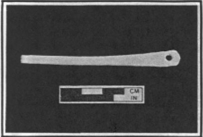 Photo 41. Bone "needle."
sides of the site suggest a general clean-up of the site and deposition of artifacts over a brief period of time. The trash disposal practices of the HT55 settlers would seem to be largely episodic in nature and not the accumulation of household refuse
over an extended period of time.
Photo 41. Bone "needle."
sides of the site suggest a general clean-up of the site and deposition of artifacts over a brief period of time. The trash disposal practices of the HT55 settlers would seem to be largely episodic in nature and not the accumulation of household refuse
over an extended period of time.
As in previously discussed categories, the well contained the majority of the wood-working, agricultural, and miscellaneous equipment. Among these artifacts were saw and plane blades and a triangular file fragment. The file is of the type most frequently associated with metal working based on its size and proportion, however, it is grouped here with the wood-working tools because of the similarity in use and form. The well also yielded three agricultural implements including two hoe collars and a spade nosing or Dutch hoe blade.
A fragment, believed to be a drawknife blade, was unearthed in a posthole of Structure C. This distinctive wood-working tool was most likely deposited in the posthole during the construction of the building though the possibility exists that it may have found its way into the ground during some subsequent repair to the structure.
Numerous bands of ferrous metal identified as barrel hoops were encountered in the well and in the cellar fill of Structure A. This was not unexpected, as barrel hoop fragments have been found on numerous sites of this period such as at College Landing (Edwards 1987). Of particular interest were the large fish hook (Catalog Number 054) and the bone "needle" (Catalog Number 112; Photo 41). The fish hook suggests the importance of local fishing as a means of supplementing the diet of early settlers, as well as possibly providing a means to obtain a saleable commodity. This large hook, measuring over 14 centimeters in overall length, would have been used to catch large species of fish, such as sturgeon, which were documented as being plentiful in the rivers and inlets of the New World (Hariot 1590:20; Smith 1624:10, 86). The presence of a bone "needle" or bodkin, of the size and type that could conveniently be used for weaving lightweight fishing nets, also suggests the importance of fishing as a means of sustenance. The "needle" or bodkin may have also been used in some textile-related activity.
The lack of concentrations of specific tool and equipment forms across the site, except in the large trash-filled well and trash pit associated with Structure A, is insufficient evidence to suggest specific craft activities on the site.
The distribution of various sizes of lead shot, from large musket balls to smaller shot used for hunting game, were found in the large trash pit just north of Structure A and in the well. Smaller quantities of shot were encountered in two of the postholes which comprised Structure B. A surprising amount of casting sprues from the 165 manufacture of lead projectiles was recovered. Until the mining of lead-rich ore began late in the colonial period, lead was in short supply in the Virginia colony and these pieces trimmed from rows of shot cast in a "gang-mold" (Peterson 1964:71) would usually have been saved and re-melted. The presence of this casting waste on HT55, along with two trigger guards (Catalog Numbers 058 and 210) and a musket barrel scouring tool (Catalog Number 066) suggest the presence of at least two firearms. One fragment of forged iron pipe (Catalog Number 135), which may be a section of gun barrel, was also encountered.
In addition to firearms, crossbows or long bows may have been present on the site. The point of an iron incendiary arrow1 (Catalog Number 031) was retrieved from Trash Pit D. One may speculate as to why and how this very specialized projectile could be used on HT55 when it was a long-outmoded weapon by the early seventeenth century in Europe. There is documentation to support the assertion that obsolete weaponry and armor was shipped to the New World, however (I. Noël Hume 1982:123); it is reasonable to assume that a projectile such as an incendiary bolt could have found its way onto HT55.
Armor plate was recovered from Trash Pits A and D and the well. Most notable was a small diamond-shaped washer (Catalog Number 063) of the type used to secure the shoulder straps of back and breast plates. Identical washers were recovered at Martin's Hundred Site "C" on nearly intact breast and back plates (see I. Noël Hume 1982:163, Figure 8-11). Various fragments of iron alloy plate were encountered, and they have tentatively been identified as armor plate. Positive identification of this type of artifact is not always possible, however, even after all conservation treatment has been completed.
Five edged-weapon accessories were recovered from the well and Trash Pits B and G. These included a sword belt hanger (Catalog Number 044), three sword belt buckles (Catalog Numbers 045, 061, and 062), and a copper alloy scabbard tip or "chape" (Catalog Number 078). The sword carriage elements are similar to those encountered at the Causey's Care site and at Martin's Hundred (Pittman 1988). The scabbard tip or "chape" is most likely part of a dagger sheath owing to its relatively small size and method of attachment.
Edged weapons were well represented among the HT55 armaments. A sword quillon or cross-guard (Catalog Number 057) was found in Trash Pit F, and a nearly complete, though badly damaged sword blade (Catalog Number 185) was found associated with Structure A. The blade appears to have been a rapier, having a single fuller, a slightly flattened point, and rectangular ricasso. The inhabitants of HT55 would appear to have been well armed with both offensive and defensive weaponry.
The personal items retrieved from HT55 demonstrate a fairly high level of affluence and, along with clothing or textile-related artifacts, provide a strong indicator of the quality of life. The presence of spurs in Trash Pits A, B, and H, and the well suggest that horses were kept on the site. As no two of the spurs match in terms of appearance, material, or size, we may surmise that there were at least four pairs of these artifacts in use at various times on the site. The ownership of horses, as indicated by the presence of spurs, has been suggested at other sites along the James River such as at Martin's Hundred, College Landing, and at Causey's Care. At all of these sites, which date to the first decades of colonization in Virginia, harness, spurs, and equestrian-related artifacts have been unearthed (Pittman 1988; Edwards 1987).
Other personal artifacts include a total of four bone or ivory hair combs, which were retrieved from Trash Pit B and the well. These double edged, rectangular combs (Catalog Number 109; Photo 42) are typical in size and form to examples found on other early colonial period sites (Pittman 1988). As Noël Hume indicates, the teeth of these
166
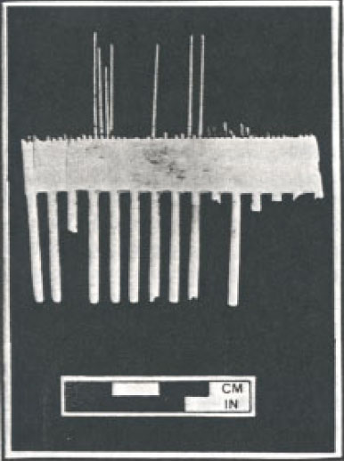 Photo 42. Bone comb.
combs are generally of different size and spacing and may have been used not only for grooming hair, but beards as well (I. Noël Hume 1978:174).
Photo 42. Bone comb.
combs are generally of different size and spacing and may have been used not only for grooming hair, but beards as well (I. Noël Hume 1978:174).
The jewelry items were significant because two fragments of what is believed to be the same silver and beaded necklace Catalog Numbers 080 and 081) were found in two different layers within Trash Pit B. These bits of twisted silver wire with small glass beads (average diameter is 0.38 cm) were attached with hooks and probably formed a simple adornment for the neck of an anonymous female settler. Another glass bead (Catalog Number 082) was retrieved from Trash Pit C, but this sole example is irregularly shaped and much larger than any of the beads which comprise the necklace.
The inhabitants of HT55 had recreational objects as well, as indicated by the presence of a copper alloy hinged book clasp (Catalog Number 234), an ivory gaming die (Catalog Number 258), and an iron jaw or "jew's" harp (Catalog Number 004). From this class of artifacts one may assume that at least one of the settlers at HT55 enjoyed music, played games of chance, and was literate.
The textile-related artifacts from HT55 are the most revealing class of finds when considering relative social status, since "it is clear … that clothing continued to define social stratification [in the seventeenth century] just as it had done through the Middle Ages"(I. Noël Hume 1982:60) . As early as 1621, the Council and Governor of the fledgling colony attempted to "suppress drunkenness gaming & excess in cloaths [and] not to permit any but ye Council & heads of hundreds to wear gold in their cloaths"(Anonymous 1908, as cited by I. Noël Hume 1982) . This sumptuary law provides us with a unique glimpse of colonial Virginia social structure. The presence of gold and silver threads (Catalog Number 122), as well as a silver aiglet (Catalog Number 160) and gold-washed clasp or buckle (Catalog Number 075) suggest that the residents of HT55 were either from the upper classes or at least had access to the hand-me-downs of the wealthy. Those who could afford a large quantity of richly decorated clothing were obviously in a position of social, financial, and presumably political power.
It is rare to recover textiles or processed fibers from seventeenth-century contexts. However, site HT55 yielded what appears to be crocheted or tatted "lace" (Catalog Numbers 137 and 147; Photo 43), which is composed of metallic wire. This type of ornamental "lace" is the type which was sewn to the cuffs and edges of doublets and bodices. In addition, site HT55 contained
59 aiglets, 12 clothing "hooks and eyes," and small clothing buckles and buttons of the type
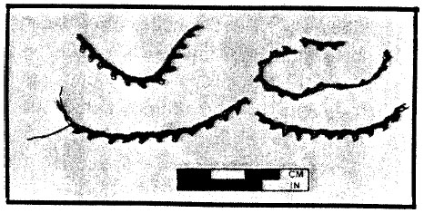 Photo 43. "Lace."
167
found at Martin's Hundred and at College Landing (Pittman 1988).
Photo 43. "Lace."
167
found at Martin's Hundred and at College Landing (Pittman 1988).
The handle of a glass linen smoother (Catalog Number 035), the elements of at least four pairs of scissors (Catalog Numbers 026, 025, 024, 023, 022, and 021), two thimbles (Catalog Numbers 071 and 070), and several pieces of thread and bullion may suggest clothing production on the site. A tenter hook (Catalog Number 040), a small L-shaped nail or hook which was used on wooden frames to stretch newly-made fabric (I. Noël Hume 1982:294), was retrieved from a posthole associated with Structure B, providing further evidence of the manufacture and maintenance of clothing. The Causey's Care excavation yielded the mushroom-like head of a glass linen smoother, while HT55 yielded a broken handle (Pittman 1988). Though the two fragments are not believed to be related, their presence on two early seventeenth-century sites so widely separated geographically, as well as on other sites in Tidewater Virginia dating to later periods, provide undeniable evidence of the importance of clothing as a social indicator.
The distribution of clothing pins across the site revealed a similar disposal pattern, with the highest concentrations occurring in the well, followed by the two trash pits north of Structure A. Other significant concentrations occurred in Trash Pits C, D, and F. The presence of such a large number of complete and fragmentary pins on a site as early as HT55 was surprising. Even if tailoring or other textile-related craft activities were not being carried on at this site, a total of 718 clothing pins found in sub-plowzone features seems an inordinately large number.
The trade-related artifacts provide a glimpse of the type of mercantile activities which were conducted on the site. The presence of a counter or jetton (Catalog Number 408; Figure 52) made by Hans Krauwinckel of Nurenburg between 1580 and 1610 exactly parallels counting pieces found at Martin's Hundred (I. Noël Hume 1982:17-18). In addition to the jetton, a Harrington farthing Type 2 (Catalog Number 407; Figure 53) was recovered from the site. This diminutive tinned copper coin was only minted some fourteen months beginning in May 1613 (Peck 1970, as cited by I. Noël Hume 1982:226; Seaby 1961). The presence of this coin again parallels examples found at Martin's Hundred (I. Noël Hume 1982:17). This rare find was excavated from a postmold associated with Structure A. A silver coin (Catalog Number 409) was also retrieved from Trash Pit A north of Structure A. This silver coin is badly worn and a positive identification has not yet been made.
Other evidence of mercantile activities rests with the presence of two twisted copper alloy wires (Catalog Numbers 077 and 121), believed to be the suspending wires of a small pan balance. Coinage of many nationalities was valued not by its face value, but rather by its weight. A small set of weights and a pan balance would have been part of any merchant's or businessman's basic equipment.
Three lead bale seals, used to identify the origin of bales of goods (usually cloth), were found in the well (Catalog Number 143), Trash Pit G (Catalog Number 195), and Trash Pit B (Catalog Number 068). Only one of these seals (Catalog Number 068; Figure 54) retained any identifiable markings. This is a double seal which still bears a portion of the impressed inscription in the form of the raised letters "…FFOL…" around the raised letters "R" and "S" within a circle. It is believed that these letters are a portion of the word SUFFOLK. On the opposite side, the raised initials "I" and "W" appear beneath a crown-like motif and above an interlocking Celtic knot design. The significance of these initials is as yet unknown.
The highest concentrations of furniture-related artifacts occurred in Trash Pit B, where 27 (69%) of the total 39 of upholstery tacks were recovered. These tacks are small, dome-headed tacks of the type used on chairs and in decorative designs
on trunks (I. Noël Hume 1978:227-228). Trunk or furniture locks (Catalog Numbers 125 and 189), hinge fragments and hinged hasps (Catalog Numbers 162, 028, 029, 030, and 197), and furniture/box handles were also encountered in the well fill layers. The iron handles (Catalog
168
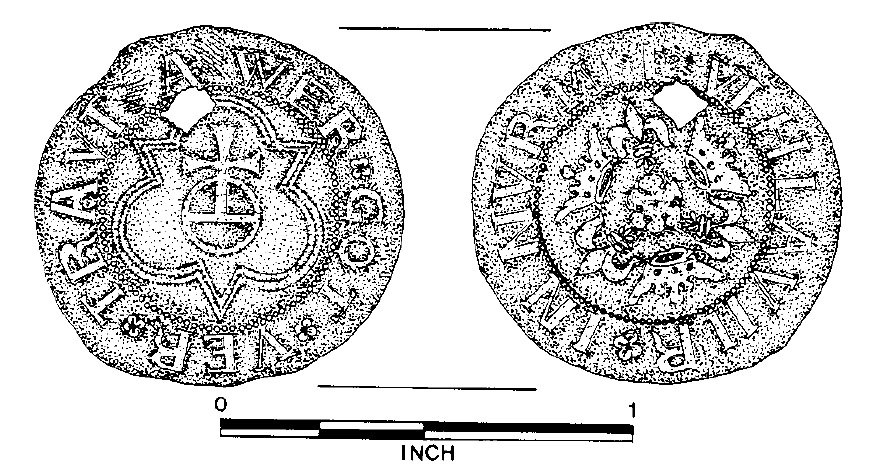 Figure 52. Krauwinckel jetton.
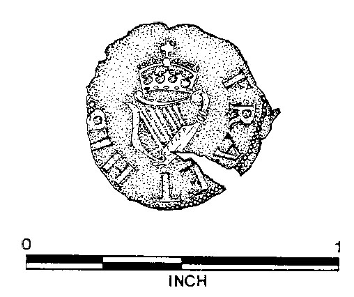 Figure 53. Harrington farthing, type 2.
Numbers 043, 175) are similar to those excavated at Martin's Hundred (Pittman 1988).
Figure 53. Harrington farthing, type 2.
Numbers 043, 175) are similar to those excavated at Martin's Hundred (Pittman 1988).
The furniture-related articles which were recovered during the excavation suggest the quality of domestic life enjoyed by the inhabitants of this site. As Barbara Carson has indicated in her detailed research into the meaning of the material possessions owned by the early settlers in Maryland in the seventeenth century, relative wealth can be gauged in terms of the quantity of objects
 Figure 54. Bale seal.
as well as by their diversity (Carson 1984). The probate inventories which form the basis of her work are largely evaluated listings of household furniture and equipment. These lists are used to interpret not only wealth, but also the functions of rooms as living spaces, specific activities performed on the site, the rearing of families, and the use of leisure time (Carson 1984). The same types of household equipment, including curtain rings, pieces of furniture, lockable boxes and/or trunks
169
are found in the archaeological record at HT55. Unfortunately, no documentary records, in the form of probate inventories, have come to light for the HT55 residents and it is, therefore, impossible to compare the written records with what is recovered from the ground. We may assume, however, that the same types of furniture and household items listed in Carson's Maryland inventories
could be found on many of the early settled areas along the James River in Virginia. We may assume that the residents of HT55 owned either tack-ornamented furniture or storage trunks which were lockable. One small iron padlock (Catalog Number 056) was identified and placed with the furniture-related finds because of its diminutive size. It is believed that this size padlock
could only have been practical on a small box or other lockable furniture item.
Figure 54. Bale seal.
as well as by their diversity (Carson 1984). The probate inventories which form the basis of her work are largely evaluated listings of household furniture and equipment. These lists are used to interpret not only wealth, but also the functions of rooms as living spaces, specific activities performed on the site, the rearing of families, and the use of leisure time (Carson 1984). The same types of household equipment, including curtain rings, pieces of furniture, lockable boxes and/or trunks
169
are found in the archaeological record at HT55. Unfortunately, no documentary records, in the form of probate inventories, have come to light for the HT55 residents and it is, therefore, impossible to compare the written records with what is recovered from the ground. We may assume, however, that the same types of furniture and household items listed in Carson's Maryland inventories
could be found on many of the early settled areas along the James River in Virginia. We may assume that the residents of HT55 owned either tack-ornamented furniture or storage trunks which were lockable. One small iron padlock (Catalog Number 056) was identified and placed with the furniture-related finds because of its diminutive size. It is believed that this size padlock
could only have been practical on a small box or other lockable furniture item.
Of particular interest are two similar iron nails which have diamond-shaped heads (Catalog Numbers 038 and 226) which were found in the
 Photo 44. Lathe-marked plaster.
 Photo 45. Roofing tile fragments.
170
well and in Trash Pit B. Decorative box nails of this size and type have not been documented on other Virginia sites in this period. The presence of two nearly identical decorative nails in features on opposite sides of the site suggest a trash disposal
pattern which is consistent with those indicated by the ceramics.
Photo 45. Roofing tile fragments.
170
well and in Trash Pit B. Decorative box nails of this size and type have not been documented on other Virginia sites in this period. The presence of two nearly identical decorative nails in features on opposite sides of the site suggest a trash disposal
pattern which is consistent with those indicated by the ceramics.
The architectural elements which were retrieved from HT55 indicate that at least one of the structures on the premises was well constructed with casement windows, and possibly a tiled roof. The relatively small quantity of lathe-marked plaster (Photo 44), roofing tile (Photo 45), and window glass fragments may represent only the unusable fragments created by the salvage of these more permanent elements of construction. Most of these architectural items were found in the well, and in contexts associated with Structure C. A smaller scattering of similar objects were found in the large trash pits north of Structure A. The deposition of this class of artifacts closely follows the same trash disposal pattern that is reflected in the distribution of the ceramics and glass artifacts.
The sample of nails which were taken from the major features of HT55 were chosen in order to reflect the range of lengths and the head configurations.
| Cup Handles | Cup/pot Handles | Pb Frags. | Cast Fe Pots | Brazier Handles | Skewers | Trivets | |
|---|---|---|---|---|---|---|---|
| Trash Pit B | 0 | 0 | 1 | 0 | 0 | 1 | 1 |
| Trash Pit D | 1 | 0 | 0 | 0 | 0 | 0 | 0 |
| Well | 1 | 1 | 0 | 4 | 1 | 0 | 0 |
| TOTALS | 2 | 1 | 1 | 4 | 1 | 1 | 1 |
| Knife Blades | Bone Cutlery Handles | Spoon Fragments | |
|---|---|---|---|
| Structure C | 1 | 0 | 0 |
| Trash Pit A | 1 | 0 | 0 |
| Trash Pit B | 1 | 3 | 1 |
| Trash Pit C | 1 | 0 | 0 |
| Trash Pit D | 4 | 2 | 0 |
| Trash Pit G | 2 | 2 | 0 |
| Trash Pit H | 1 | 0 | 0 |
| Well | 17 | 3 | 2 |
| TOTALS | 28 | 10 | 3 |
| Wood Working | Agricultural Implements | Miscellaneous Equipment | |
|---|---|---|---|
| Structure A | 0 | 0 | 1 |
| Structure C | 1 | 0 | 0 |
| Trash Pit A | 1 | 0 | 0 |
| Trash Pit B | 1 | 1 | 4 |
| Trash Pit D | 1 | 0 | 0 |
| Well | 3 | 3 | 5 |
| TOTALS | 7 | 4 | 10 |
| Pb Shot | Casting Sprues | Gun Parts Edged Weapons | Sword Accessories | Armor Plate | ||
|---|---|---|---|---|---|---|
| Structure A | 0 | 0 | 0 | 1 | 0 | 0 |
| Structure B | 4 | 0 | 0 | 0 | 0 | 0 |
| Trash Pit A | 3 | 5 | 0 | 0 | 0 | 3 |
| Trash Pit B | 41 | 74 | 2 | 0 | 1 | 0 |
| Trash Pit D | 2 | 1 | 0 | 1 | 0 | 1 |
| Trash Pit F | 0 | 13 | 0 | 1 | 0 | 0 |
| Trash Pit G | 0 | 0 | 0 | 0 | 3 | 0 |
| Trash Pit H | 3 | 0 | 1 | 0 | 0 | 0 |
| Well | 12 | 1 | 1 | 0 | 1 | 2 |
| TOTALS | 65 | 94 | 4 | 3 | 5 | 6 |
| Equestrian Equipment | Jewelry Items | Personal Grooming | Recreational Objects | |
|---|---|---|---|---|
| Trash Pit A | 1 | 0 | 0 | 1 |
| Trash Pit B | 1 | 2 | 1 | 1 |
| Trash Pit C | 0 | 1 | 0 | 0 |
| Trash Pit H | 1 | 0 | 0 | 0 |
| Well | 2 | 1 | 3 | 1 |
| TOTALS | 5 | 4 | 4 | 3 |
| Thimbles | Scissor Parts | "Eyes" | "Hooks" | Buckles/Clasps | Aiglets | Buttons | |
|---|---|---|---|---|---|---|---|
| Structure A | 0 | 0 | 0 | 0 | 0 | 1 | 0 |
| Structure B | 0 | 0 | 0 | 0 | 0 | 2 | 0 |
| Structure C | 1 | 0 | 1 | 2 | 0 | 0 | 0 |
| Trash Pit A | 1 | 0 | 2 | 0 | 0 | 16 | 1 |
| Trash Pit B | 0 | 0 | 4 | 6 | 1 | 18 | 0 |
| Trash Pit C | 0 | 0 | 0 | 0 | 0 | 1 | 0 |
| Trash Pit D | 0 | 3 | 0 | 0 | 0 | 2 | 0 |
| Trash Pit F | 0 | 0 | 0 | 0 | 0 | 2 | 0 |
| Trash Pit G | 0 | 0 | 0 | 0 | 0 | 1 | 0 |
| Trash Pit H | 0 | 0 | 0 | 1 | 0 | 2 | 0 |
| Slot Fence A | 0 | 0 | 0 | 0 | 0 | 2 | 0 |
| Fence | 0 | 0 | 0 | 0 | 0 | 2 | 1 |
| Well | 2 | 3 | 5 | 2 | 1 | 10 | 1 |
| TOTALS | 4 | 6 | 12 | 12 | 3 | 59 | 3 |
| Linen Smoothers | Bullion/"Lace" | Cu alloy/"Lace" | Tenter Hooks | Au/Ag Thread | |
|---|---|---|---|---|---|
| Structure B | 1 | 0 | 0 | 0 | 0 |
| Trash Pit A | 0 | 0 | 0 | 1 | 0 |
| Trash Pit B | 0 | 0 | 2 | 0 | 0 |
| Well | 0 | 1 | 2 | 0 | 1 |
| TOTALS | 1 | 1 | 4 | 1 | 1 |
| Complete or Headed Shanks | Headless Shanks | |
|---|---|---|
| Structure A | 2 | 2 |
| Structure B | 1 | 0 |
| Structure C | 7 | 1 |
| Trash Pit A | 93 | 5 |
| Trash Pit B | 84 | 14 |
| Trash Pit C | 58 | 24 |
| Trash Pit D | 46 | 0 |
| Trash Pit F | 44 | 24 |
| Trash Pit G | 7 | 3 |
| Trash Pit H | 16 | 2 |
| Slot Fence A | 6 | 0 |
| Well | 240 | 28 |
| Feature 82 | 3 | 0 |
| Feature 104 | 3 | 0 |
| Feature 239 | 1 | 0 |
| Feature 254 | 3 | 0 |
| Feature 309 | 1 | 0 |
| TOTALS | 615 | 103 |
| Casting Counters | Coinage | Bale Seals | Weighing Equipment | |
|---|---|---|---|---|
| Structure A | 0 | 1 | 0 | 0 |
| Trash Pit A | 0 | 1 | 0 | 0 |
| Trash Pit B | 0 | 0 | 1 | 0 |
| Trash Pit D | 1 | 0 | 0 | 0 |
| Trash Pit G | 0 | 0 | 1 | 0 |
| Well | 0 | 0 | 1 | 2 |
| TOTALS | 1 | 2 | 3 | 2 |
| Curtain Rings | Tacks | Keys | Hinges/Hasps | Trunk Locks | Furniture Handles | Diamond-Head Nails | |
|---|---|---|---|---|---|---|---|
| Structure C | 1 | 1 | 0 | 0 | 0 | 0 | 0 |
| Trash Pit A | 1 | 2 | 1 | 3 | 0 | 0 | 0 |
| Trash Pit B | 0 | 27 | 0 | 0 | 0 | 0 | 1 |
| Trash Pit D | 0 | 0 | 0 | 1 | 0 | 0 | 0 |
| Trash Pit F | 0 | 0 | 0 | 0 | 1 | 0 | 0 |
| Trash Pit G | 0 | 5 | 0 | 0 | 0 | 0 | 0 |
| Well | 1 | 2 | 1 | 1 | 2 | 3 | 1 |
| Context 013 | 0 | 1 | 0 | 0 | 0 | 0 | 0 |
| Context 191 | 0 | 1 | 0 | 0 | 0 | 0 | 0 |
| TOTALS | 3 | 39 | 2 | 5 | 3 | 3 | 2 |
| Door Locks | Window Lead | Door Keys | Window Glass | Roof Tiles | Door Hinges | Plaster | |
|---|---|---|---|---|---|---|---|
| Structure A | 0 | 1 | 0 | 0 | 0 | 0 | 0 |
| Structure C | 0 | 10 | 0 | 0 | 1 | 0 | 0 |
| Trash Pit A | 2 | 3 | 0 | 1 | 0 | 1 | 0 |
| Trash Pit B | 1 | 0 | 0 | 0 | 0 | 0 | 0 |
| Trash Pit D | 0 | 0 | 0 | 0 | 0 | 1 | 0 |
| Well | 3 | 8 | 1 | 1 | 1 | 0 | 1 |
| TOTALS | 6 | 22 | 1 | 2 | 2 | 2 | 1 |
Chapter 8.
Conclusions
A. The Prehistoric Sites
Excavations at Hampton University have contributed to our understanding of the lifeways of Native American peoples in the Outer Coastal Plain of Virginia during the latter portion of the Woodland I Period. The excavation areas opened at sites HT36 and HT37 held the remains of what appeared to be small, residential bases dating from ca. A.D. 1-400. Site HT55 was occupied for only rather limited use during both the Woodland I and Woodland II Periods.
Sites HT36 and HT37 are typical of the Woodland I Period, as they display evidence of a estuarine adaptation. Similar to several other known base camps, the sites at Hampton University were situated within a topographic setting which would have provided easy access to rich estuarine resources, in this case found within and along the waterways of the Hampton River and Hampton Roads. A springhead located nearby would have made the Hampton setting additionally attractive.
The archaeological remains documented at HT36 and HT37 suggest that a variety of activities were carried out there. Direct evidence of an estuarine focus was provided by the shellfish remains recovered at the sites. Although paleoethnobotanical remains were sparse, analysis of these indicated that subsistence activities also may have included the gathering of both wild mast and seed crops, and possibly plant cultivation. Plant remains recovered from the features included acorn, thickshell hickory nut, smartweed, and one possible kernel of corn. Grinding and anvil stones found at the sites may have been used to process these foods.
The variety of pit features present at the sites were also suggestive of a range of activities. Small, shell-filled pits such as Features 1002/1005 and 1003/1018 at HT37 may have been used for food processing. Larger pits such as Features 4/5/6, 13/14, 42/47/48/122, and 71 at HT36 and Features 1024 and 1030 at HT37 may have served a food storage function. Analysis of the ceramic remains suggested that the two broader areas defined by the excavation unit opened at each site may have functioned differently. The very small sample of rim sherds available for study indicated that vessels in both jar and bowl forms were present in the collection from HT36, while only jars were recovered from HT37. Possible evidence of ceramic manufacturing activity was found at HT37.
It is difficult to assess the meaning of the internal structure of sites HT36 and HT37 in terms of the size of the population groups represented. Two possible clusters of features were evident at HT37, but the pit features at HT36 were more scattered. The range of radiocarbon dates obtained from the sites suggest that overlapping settlements are represented among the number of pit features uncovered. The relatively small size of the artifact collection recovered from the area might also be interpreted as indicating that only small population units used the sites. It is possible, however, that the inhabitants disposed of their debris at an as yet undetermined location, perhaps along the shoreline as has been found at the Addington site in Virginia Beach (Geier 1986).
That the prehistoric settlements at Hampton University were of some permanency seems certain. The variety of activities represented by the archaeological remains suggested that the sites did function as base camps. Paleoethnobotanical evidence indicated that occupation occurred at least during the fall or winter seasons. Labor was apparently invested in constructing storage facilities, and the storage pits themselves suggest that the sites served as base camps occupied for extended stays. The presence of storage features as well as 176 the secondary burial found at HT37 might also indicate that the sites served as permanent bases which could be returned to at periodic intervals.
B. The Historic Site (Photo 46)
Doing archaeology has been equated with reading a unique copy of an ancient book, removing each page as you finish reading it, then burning the page, until the entire volume is consumed. An archaeological site is necessarily (and hopefully systematically) destroyed by digging, the very process by which it is "saved." Time, war, and neglect have left very little of the early seventeenth-century historical record in this area. Speculations based on grants and leases suggest that the little complex was owned by Christopher Windmill or the mysterious Walter Heley, then subsequently by Francis Hough, Joseph Hatfield, Henry Coleman, and Henry Poole. Another interpretation of the records may suggest that the property was part of the Glebe Lands associated with the nearby second church of Elizabeth City Parish, erected sometime between 1624 and 1637. So archaeology should be able to help clarify the documentary record. Unfortunately, however, none of the artifacts recovered from the site was helpful in determining who lived there, nor was there any item found that may have betrayed even the occupation of the householder(s). Virtually all that remained of HT55 was the archaeological record, a fragile imprint of seventeenth-century Virginia culture amidst a flurry of development riding high on Tidewater's newly-found prosperity. That the site was preserved, mostly intact, for over 300 years is quite remarkable in itself.
The archaeological record, in this instance, consisted of a brick-lined cellar, numerous post holes delineating several earthfast structures and fence lines, and evidence of trash pits, slot fence trenches, and a well. As is the case with all other sites in Tidewater dating from the first half of the seventeenth century, nothing at all survived above ground. The principal reason for this, of course, was the propensity early Virginians had for using flammable termite food for their primary building material. Why wood was chosen for use both in structures and their foundations, has been subject to extensive discussion among archaeologists, architectural historians, and social historians for more than two decades. The reason that is most obvious, of course, is that wood was both plentiful and cheap. Although "all wood" construction was employed in all areas of the South, in the Middle Atlantic Tidewater, in New England, and even in Bermuda in the beginning, it survived in Tidewater longer than any other region. Tidewater Virginia and Maryland were established for, and the economy based upon, the growing of tobacco. Upon arrival, new immigrants to Tidewater were principally concerned with throwing up temporary shelters and then establishing and embellishing more suitable housing as they could afford it and the materials became available. Unfortunately, several events and conditions in the first half of the seventeenth century delayed their plans for substantially improving their lot. The price of tobacco took a resounding dive in the 1620s, meaning less profit for more work. Additionally, the very nature of tobacco farming was quite labor-intensive; therefore, what profits were derived from selling on a deflated market, had to be plowed back into the farm in the form of enlarging one's labor force (Carson 1981, Neiman 1980). The initial expense of buying more slaves or sponsoring more indentures was compounded by having more people to feed, house, and clothe.
Another condition factoring into the "impermanence/permanence" argument was the very high mortality rate exhibited in the first half of the century. Children were orphaned, families split, and farms changed hands quite frequently. There was probably little thought on the part of young parents of passing along an inheritance or family home to their children, and more emphasis was placed on surviving and eking out a living. The population did not stabilize until the end of the seventeenth century, which is when substantial housing becomes the norm rather than the exception (Neiman 1980).
177 Photo 46. Overall, structural post holes and cellar of Structure A, ground view.
These factors may partially explain why so-called "impermanent" housing was so extensively used throughout Tidewater. Neiman (1980) points out, however, that even folks who could surely afford better, more "permanent" accommodations, often chose to live in totally wooden buildings. All impermanent buildings were not necessarily crude; some of the wooden houses of the more affluent were probably fairly comfortable, even by today's standards, having glass windows, tile roofs, cellars, separate kitchens and other amenities.
The settlers of the early seventeenth century had a very different set of values than their great-grandchildren of the next century. This is reflected in several aspects of their material culture aside from housing. Most meals, for example, were cooked in one pot, from which a portion was ladled out to everyone in the household. The now-common place settings of like-patterned plates, cups, and saucers with matched silver ware simply did not exist. Houses had few, if any, private spaces. A family often slept in the same room in which they received guests and conducted business. Life in the seventeenth century had not yet the almost-excessive quest for order that would ensue in the Georgian period of the eighteenth century. The symmetrical brick or clapboard Georgian house, with separate private and public rooms, was not yet transplanted to Tidewater Virginia, and neither was it strived for.
Site HT55 was in many ways a time capsule, showing a very typical part of seventeenth-century 178 life. The first occupation of the site consisted of a two-bay house of wood and mud, probably paled in but with no other buildings. The inhabitants must have prospered somewhat, because within ten or fifteen years, if not sooner, other houses were built and one at least was later embellished with glass windows, possibly a tile roof, a passage and a brick-lined storage cellar. The artifacts reflected some degree of wealth; even so, over a possible occupation of forty years, a lifetime in those days, no "substantial" housing was built.
It is not known why the site was abandoned in the 1650's or 1660's. The general time of departure does, however, coincide with two significant events. The more catastrophic was a very large and intense Category 3 hurricane which struck Hampton Roads in late summer 1667. Reportedly, over 10,000 houses were destroyed in Virginia alone (Holt 1985). Given the site's proximity to both the Hampton River and the Chesapeake Bay, it is quite possible, even likely that substantial damage could have been sustained from the winds of such a storm. Less dramatically, the second church of Elizabeth City Parish was also abandoned around this time, possibly as a result of the hurricane, although folks continued to be buried there until about the last decade of the seventeenth century (Holt 1985). If the occupants were in some way associated with the church, it is likely that they moved at the same time, whether or not their home had been destroyed.
Thus, it is possible that the abandonment of HT55 was directly related to the relocation of the church to the west side of the river. If the site was part of the glebe lands which housed the minister and his family, it follows that the relocation of the church would cause the minister to seek accommodations on the west side of the river where a new church had been built at Pembroke Farms by 1667 (U.A.J.V. 1983).
Hampton University's historic site has added significantly to the inventory of earthfast dwellings in Virginia and Maryland and to our knowledge of them and, more importantly, the folks who lived there. Hopefully, this report will provide a starting point for more intensive research by archaeologists, architectural historians, and other scholars who have an avid interest in the shadowy beginnings of our country.
References
- 1981
- Virginia: A Geographic and Demographic Profile. In A Virginia Profile, edited by John V. Moesser. Commonwealth Books, Palisade Park, New Jersey.
- 1973
- Vine Weeds of the North Central States. University of Illinois Urbana-Champaign, College of Agriculture, Cooperative Extension Service Circular No. 1075.
- 1977
- Chenopod as Cultigen: A Reevaluation of Some Prehistoric Collections from Eastern North America. Midcontinental Journal of Archaeology 2:3-46.
- 1985
- Prehistoric Cultivation in West-Central Illinois. In Prehistoric Food Production in North America, edited by Richard I. Ford, pp. 149-203. Anthropological Papers No. 75. University of Michigan, Museum of Anthropology, Ann Arbor.
- 1985
- a Archeobotany. In Smiling Dan: Structure and Function at a Middle Woodland Settlement in the Illinois Valley, edited by B.D. Stafford and M.B. Sant, pp. 327-401. Research Series No. 2. Kampsville Archaeological Center, Kampsville.
- 1981
- Archeobotany of Newbridge, Carlin, and Weitzer Sites—The White Hall Components. In Faunal Exploitation and Resource Selection: Early Late Woodland Subsistence in the Lower Illinois Valley (Appendix B), by B.W. Styles, pp. 275-291. Scientific Papers No. 3. Northwestern University Archaeological Program, Evanston.
- 1985
- Archeobotany. In Deer Track: A Late Woodland Village in the Mississippi Valley, edited by C.R. McGrimsey and M.D. Conner, pp. 44-117. Technical Report No. 1. Kampsville Archaeological Center, Kampsville.
- 1972
- A Brief Guide for the Identification of Dutch Clay Tobacco Pipes Found in England. Post-Medieval Archaeology 6:175-182. London.
- 1978
- Faunal Remains from the Maine Site. Unpublished manuscript on file, Virginia Division of Historic Landmarks, Richmond.
- 1981
- The Vertebrate Faunal Utilization Pattern of the Middle Woodland Mockley Ceramic Users: The Maycock's Point Shell Midden Site, Prince George County, Virginia. Unpublished manuscript on file, Virginia Division of Historic Landmarks, Richmond.
- 1976
- The Archaeology of Flowerdew Hundred Plantation: The Stone House Foundation Site. Southside Historical Sites Foundation and the College of William and Mary, Williamsburg. 180
- 1969
- The Chickahominy River Survey of Eastern Virginia. Eastern States Archaeological Federation 26-27.
- 1977
- Early Shell Tempered Pottery in the James River Valley, Virginia. Eastern States Archaeological Federation Bulletin 36.
- 1976
- An Archaeological Survey of Mulberry Island, Fort Eustis, Newport News, Virginia. Unpublished manuscript on file at the Virginia Division of Historic Landmarks, Richmond.
- 1983
- Pajatambo: An 18th-Century Roadside Structure in Peru. Historical Archaeology 17(1):54-68.
- 1985
- The Age of Maize in the Greater Southwest: A Critical Review. In Prehistoric Food Production in North America, edited by Richard I. Ford, pp. 279-308. Anthropological Papers No. 75. University of Michigan, Museum of Anthropology, Ann Arbor.
- 1947
- The History and Present State of Virginia . Originally published 1705. Edited by Louis B. Wright. University of North Carolina Press, Chapel Hill.
- 1986
- Corn and Other Plants from Prehistory into History in the Eastern United States. In The Protohistoric Period in the Mid-South: 1500-1700, edited by D.H. Dye and R.C. Brister, pp. 3-13. Archaeological Report No. 18. Mississippi Department of Archives and History.
- 1952
- Further Comments on Simple- Stamped Shell-Tempered Pottery. American Antiquity 17:257-258.
- 1963
- Aboriginal Ceramics. In The Townsend Site Near Lewes, Delaware, edited by H.G. Omwake and T.D. Stewart. The Archaeolog 15(1):14-39.
- 1978
- A New Method for Calculating Dates from Kaolin Pipe Stem Samples. Historical Archaeology: A Guide to Substantive and Theoretical Contributions, edited by Robert L. Schuyler, pp.66-67, Baywood, New York.
- 1968
- Bertie Count Oolitic Quartzite and Its Aboriginal Utilization in Eastern Virginia and North Carolina. Chesopien 6(2):32-43.
- 1979
- Analysis of the Faunal Remains from Clifts Plantation. In Field Archaeology of the Clifts Plantation Site, by Fraser D. Neiman. Unpublished manuscript on file, Department of Archaeological Research, Colonial Williamsburg Foundation, Williamsburg.
- 1981
- European Clay Pipe Marks from 17th-Century Onondaga Iroquois Sites. Archaeology of Eastern North America 9. The Eastern States Archaeological Federation, Washington, Connecticut. 181
- 1986
- Study Unit X: Establishment of Colonial Society. In Toward a Resource Protection Process: Management Plans for James City County, York County, City of Poquoson, and City of Williamsburg. Unpublished manuscript on file, Department of Archaeological Research, The Colonial Williamsburg Foundation, Williamsburg.
- 1986
- Introduction. In Toward a Resource Protection Process: Management Plans for James City County, York County, City of Poquoson, and City of Williamsburg. Unpublished manuscript on file, Department of Archaeological Research, The Colonial Williamsburg Foundation, Williamsburg.
- 1982
- Tooth Eruption and Epiphyseal Fusion in Pigs and Wild Boar. In Ageing and Sexing Animal Bones from Archaeological Sites, edited by Bob Wilson, Caroline Grigson, and Sebastian Payne, pp. 55-71. B.A.R. British Series 109. B.A.R., Oxford, England.
- 1984
- Living Habits in 17th-Century Maryland. Paper presented at "Maryland, A Product of Two Worlds" Conference, St. Mary's City.
- 1981
- Impermanent Architecture in the Southern American Colonies. Winterthur Portfolio 16(2/3):135 196.
- 1971
- The Study of Animal Bones from Archaeological Sites. Seminar Press, New York.
- 1987
- Evidence for Early Maize (Zea mays) from the Icehouse Bottom Site, Tennessee. American Antiquity 52:352-354.
- 1984
- English Glass. Edited by Hugh Wakefield. English Decorative Arts Series. George Allen and Unwin, London.
- 1986
- Shellfishing Season in the Prehistoric Southwestern United States. American Antiquity 51(1):21-37.
- 1964
- The Formative Cultures of the Carolina Piedmont. Transactions of the American Philosophical Society 54, Part 5 (New Series).
- 1984
- The Zooarchaeology of the Storehouse and the Dry Well at Monticello. American Antiquity 49(3):542-558.
- 1988
- The Clay Pipes from Green Springs Plantation (44JC9), Virginia. Historical Archaeology 22:83-97.
- 1972
- Sixteenth-Century Glass-making in Yorkshire: Excavations at Furnaces at Hutton and Rosedale, North Riding, 182 1968-1971. Post-Medieval Archaeology 6:107-159. London.
- 1987
- Chinese Export Porcelain in Eighteenth-Century Tidewater Virginia. In Studies in Eighteenth- Century Culture, Volume 17, edited by John Yolton and Leslie Ellen Brown. American Society for Eighteenth-Century Studies. Colleagues Press, Lansing, Michigan.
- 1984
- Delaware Prehistoric Archaeology: An Ecological Approach. Associated University Presses, Cranbury, New Jersey.
- 1989
- Prehistoric Cultures of the Delmarva Peninsula: An Archaeological Study. University of Delaware Press, Newark.
- 1976
- Plants from Archaeological Sites East of the Rockies. University of Missouri-Columbia, American Archaeology Division, Report No. 1.
- 1986
- Slavery in the Colonial Chesapeake. The Foundations of America Series, Essays from Colonial Williamsburg. The Colonial Williamsburg Foundation, Williamsburg.
- 1987
- Artifacts of the Spanish Colonies of Florida and the Caribbean, 1500-1800. Volume I: Ceramics, Glassware, and Beads. Smithsonian Institution Press, Washington.
- 1987
- Harrington Histograms versus Binford Mean Dates as a Technique for Establishing the Occupational Sequence of Sites at Flowerdew Hundred, Virginia. American Archaeology, 6(1):62-67.
- n.d.
- The York County Archaeological Survey, Draft Report. Unpublished manuscript on file, Virginia Division of Historic Landmarks, Richmond.
- 1984
- Hallucinogens: Cross-Cultural Perspectives. University of New Mexico Press, Albuquerque.
- 1983
- Analysis of Oyster Shell Remains and Other Ecofacts from a Late Woodland Pit at the Island Field Site (7K-f-17), Kent County, Delaware. University of Delaware Center for Archaeological Research, Newark, Delaware.
- 1934
- A Huguenot Exile in Virginia. Edited by Gilbert Chinard. New York.
- 1987
- Archaeology at Port Anne: A Report on Site CL7, An Early 17th Century Colonial Site. Unpublished manuscript on file, Department of Archaeological Research, The Colonial Williamsburg Foundation, Williamsburg.
- 1988
- Archaeological Investigations at Croaker Landing, 44JC70 and 44JC71. Research Report Series 4. 183 Virginia Division of Historic Landmarks, Richmond.
- 1982
- Indian Ceramics from Coastal Plain Virginia. Archaeology of Eastern North America 10:95-117.
- 1988
- Decorated Clay Tobacco Pipes from the Chesapeake. Unpublished Ph.D. dissertation, Department of Anthropology, University of California, Berkeley.
- 1968
- Archaeological Systems Theory and Early Mesoamerica. In Anthropological Archaeology in the Americas, edited by Betty J. Meggers, pp. 67-87. Anthropological Society of Washington, Washington, DC.
- 1981
- Preliminary Report of Archaeological Investigation of 44VB7. Unpublished manuscript on file, Virginia Division of Historic Landmarks, Richmond.
- 1979
- Gathering and Gardening: Trends and Consequences of Hopewell Subsistence Strategies. In Hopewell Archaeology: The Chillicothe Conference, edited by D.S. Brose and N. Greber. Kent State University Press, Kent, Ohio.
- 1981
- Gardening and Farming Before A.D. 1000: Patterns of Prehistoric Cultivation North of Mexico. Journal of Ethnobiology 1:6-27.
- 1983
- The Evolution of Corn Revisited. The Quarterly Review of Archaeology 1983:12-16.
- 1982
- Glass and Archaeology. Academic Press, London.
- 1985
- Domestication and Diffusion of Maize. In Prehistoric Food Production in North America, edited by Richard I. Ford, pp. 245-278. Anthropological Papers No. 75. University of Michigan, Museum of Anthropology, Ann Arbor.
- 1964
- The American Oyster Crassostrea virginica Gmelin. United States Government Printing Office, Washington.
- 1980
- Subsistence-Settlement Patterns and Site Distributions in the Middle Atlantic. Archaeological Society of Washington Paper, Washington.
- 1985
- Proposal for a Planning Conference on Foodways. Unpublished manuscript on file, Department of Archaeological Research, Colonial Williamsburg Foundation, Williamsburg.
- 1986
- Archaeological Mitigation of Two Components (44VB9 and 44VB92) of the Great Neck Site Complex, Virginia Beach, Virginia. Volumes I V. James Madison University Archaeological Research Center, Harrisonburg.
- 1983
- The Skiffes Creek Site (44NN77): A Multicomponent Middle Woodland 184 Base Camp in Newport News, Virginia. Occasional Papers in Anthropology 17. James Madison University, Harrisonburg, Virginia.
- 1986
- The Addington Site (44VB9): Report of Findings. In Archaeological Mitigation of Two Components (44VB9 and 44VB92) of the Great Neck Site Complex, Virginia Beach, Virginia, edited by Clarence T. Geier. Volume II. James Madison University Archaeological Research Center, Harrisonburg.
- 1977
- Uses of Plants by the Indians of the Missouri River Region. University of Nebraska Press, Lincoln.
- 1963
- Manual of Vascular Plants of the Northeastern United States and Adjacent Canada. Van Nostrand, New York.
- 1985
- A Compilation of Radiocarbon Dates with Applicability to Central Virginia. Quarterly Bulletin of the Archaeological Society of Virginia 40(4):180-200.
- 1975
- The Development of English Glassmaking 1560-1640. The University of North Carolina Press, Chapel Hill.
- 1964
- Indian and Spanish Selected Writings. University of Miami Press, Coral Gables.
- 1968
- Spanish Majolica in the New World. Yale University Publications in Anthropology No. 72. Department of Anthropology, Yale University, New Haven.
- 1887
- The Fisheries and Fishery Industries of the United States. Government Printing Office, Washington.
- 1982
- The Use of Tooth Wear as a Guide to the Age of Domestic Ungulates. In Ageing and Sexing Animal Bones from Archaeological Sites, edited by Bob Wilson, Caroline Grigson, and Sebastian Payne, pp. 91-108. B.A.R. British Series 109. B.A.R., Oxford, England.
- 1984
- Quantitative Zooarchaeology: Topics in the Analysis of Archaeological Faunas. Academic Press, Orlando.
- 1986
- Marks on Milled Window Leads. Post-Medieval Archaeology 20:303 309. London.
- 1590
- A Briefe and True Report of the New Found Land of Virginia. London.
- 1969
- Textbook of Dendrology: Covering the Important Forest Trees of the United States and Canada. Fifth edition. McGraw Hill, New York. 185
- 1948
- Plain Stamped, Shell Tempered Pottery from North Carolina. American Antiquity 13:251-252.
- 1978
- Dating Stem Fragments of Seventeenth and Eighteenth-Century Clay Tobacco Pipes. Historical Archaeology: A Guide to Substantive and Theoretical Contributions, edited by Robert L. Schuyler, pp. 63-65, Baywood, New York.
- 1981
- Seventeenth-Century English and Dutch Clay Pipes from the VRCA Study Collection. Unpublished manuscript on file, Virginia Division of Historic Landmarks, Richmond.
- 1957
- A True Discourse of the Present State of Virginia. Originally published 1615. Virginia State Library, Richmond.
- 1976
- Preliminary Investigation into the Phenomenon of the Terra-cotta Clay Tobacco Pipe. Unpublished manuscript on file, Virginia Division of Historic Landmarks, Richmond.
- 1979
- Terra-cotta Tobacco Pipes in 17th Century Maryland and Virginia: A Preliminary Study. Historical Archaeology 13:14-37.Higgs, Eric S., and Claudio Vita-Finzi
- 1972
- Prehistoric Economies: A Territorial Approach. In Papers in Economic Prehistory, edited by Eric S. Higgs, pp. 27-36. Cambridge University Press, London.
- 1928
- Fishes of Chesapeake Bay. T.F.H. Publications, Inc., Neptune, New Jersey.
- 1985
- The Second Church of Elizabeth City Parish. Archaeological Society of Virginia Special Publication No. 13. Archaeological Society of Virginia, Richmond.
- 1979
- Servant Emigration to the Chesapeake in the Seventeenth Century. In The Chesapeake in the Seventeenth Century, edited by Thad W. Tate and David Ammerman, pp. 51-95, W.W. Norton and Co., New York.
- 1985
- Phase I Archaeological Reconnaissance Survey of the Proposed Route 199 Project, James City and York Counties, Virginia. Unpublished manuscript on file, Virginia Department of Transportation, Richmond.
- 1986
- Study Unit III: Permanent Settlement and Population Growth. In Toward a Resource Protection Process: Management Plans for James City County, York County, City of Poquoson, and City of Williamsburg. Unpublished manuscript on file, Department of Archaeological Research, The Colonial Williamsburg Foundation, Williamsburg.
- 1984
- Phase II Archaeological Testing of the Proposed Second Street Extension, 186 York County and Williamsburg, Virginia. Report on file, Virginia Department of Transportation, Richmond.
- 1988
- The Oyster's Smile is Fading, to the Horror of Gourmets. Smithsonian 1:60-71.
- 1984
- Paleoethnobotany. In American Bottom Archaeology: A Summary of the FAI-270 Project Contribution to the Culture History of the Mississippi River Valley, edited by C. J. Bareis and J. W. Porter. University of Illinois Press, Urbana.
- 1978
- Unthinking Decision: Enslavement of Negroes in America to 1700. In Interpreting Colonial America, edited by James Kirby Martin, pp.140-161,. Second edition. Harper and Row, New York.
- 1979
- "In Dispers'd Country Plantations": Settlement Patterns in Seventeenth- Century Surry County, Virginia. In The Chesapeake in the Seventeenth Century, edited by Thad W. Tate and David Ammerman, pp. 183-205,. W.W. Norton and Co., New York.
- 1984
- Kingsmill Plantations 1619-1800: Archaeology of Country Life in Colonial Virginia. Academic Press, Orlando.
- n.d.
- Making Dead Oysters Talk. Maryland Historical Trust Monograph Series. Maryland Historical Trust, Annapolis.
- 1988
- A Comparative Midden Analysis of a Household and Inn in St. May's City, Maryland. Historical Archaeology 22(2):17-39.
- 1987
- Tobacco Pipes from Site CL7—Port Anne. Unpublished manuscript on file, Department of Archaeological Research, The Colonial Williamsburg Foundation, Williamsburg.
- 1984
- Life in the Chesapeake Bay. The John Hopkins University Press, Baltimore.
- 1988
- Spatial and Temporal Variability in Mississippian Subsistence: The Archaeobotanical Record. Paper presented at the 46th International Congress of Americanists, Amsterdam.
- 1988
- Untitled Paper. Paper presented at the annual meeting of the Archaeological Society of Virginia, Hampton, October 1, 1988.
- 1983
- Phase II Archaeological Survey of a Proposed Dredging Site in the Hampton River, Hampton, Virginia. Unpublished report prepared by Underwater Archaeological Joint Ventures for Langley and MacDonald, Inc. 187
- 1953
- The Potts Site, Chickahominy River, New Kent County. Quarterly Bulletin of the Archaeological Society of Virginia 8(1).
- 1958
- The Kiskiack (Chiskiack) Indian Site Near Yorktown, Virginia. Quarterly Bulletin of the Archaeological Society of Virginia 13(2).
- 1965
- The DeShazo Site, King George County, Virginia. Quarterly Bulletin of the Archaeological Society of Virginia 19(4):98-104.
- 1961
- Seed Identification Manual. University of California Press, Berkeley.
- 1984
- The Role of Pewter as a Missing Artifact: Consumer Attitudes Toward Tablewares in Late 18th-Century Virginia. Historical Archaeology 23(2), forthcoming.
- 1984
- Colonization and Subsistence Change on the 17th Century Chesapeake Frontier. Unpublished Ph.D. dissertation, Department of Anthropology, Michigan State University, Lansing. University Microfilms, Ann Arbor.
- 1985
- An Excavation at the Point of Fork Site (44FV19), Fluvanna County, Virginia. Bulletin of the Fluvanna County Virginia Historical Society.
- 1987
- a Farming, Foraging, and Feasting: Powhatan Foodways and their Influences on English Virginia. Paper presented at the Foodways Research Planning Conference, Williamsburg, Virginia.
- 1987
- b Everything in its Place...: Locational Models and Notions of Elite in Virginia, 1660-1865. Paper presented at the Annual Conference of The Society for Historical Archaeology, January, 1987, Savannah.
- 1980
- Phase I Cultural Resource Evaluation of the Oakland Dairy Property, Newport News, Virginia. Unpublished manuscript on file, Virginia Division of Historic Landmarks, Richmond.
- 1989
- Archaeological Investigations Prior to the Construction of the Proposed Carter's Grove Archaeological Museum, 1988. Unpublished manuscript on file, Department of Archaeological Research, The Colonial Williamsburg Foundation, Williamsburg.
- 1978
- Domestic Architecture at the Clift's Plantation: The Social Context of Early Virginia Building. Northern Neck of Virginia Historical Magazine XXVIII: 3096-3128.
- 1980
- The "Manner House" Before Stratford (Discovering Clifts Plantation). A Stratford Handbook. Stratford, Virginia.
- 1736
- The City and Country Purchaser's and Builder's Dictionary. Third edition. London. 188
- 1979
- Clay Tobacco Pipes Excavated at Martin's Hundred, Virginia, 1976-1978. In The Archaeology of the Clay Tobacco Pipe, edited by Peter Davey. BAR International Series 60, Oxford, England.
- 1966
- Excavations at Clay Bank in Gloucester County, Virginia, 1962-1963. Contributions from the Museum of History and Technology, Smithsonian Institution, Paper 45. Smithsonian Institution, Washington.
- 1969
- A Guide to Artifacts of Colonial America. Alfred A. Knopf, New York.
- 1978
- A Guide to Artifacts of Colonial America. Second edition. Alfred A. Knopf, New York.
- 1979
- First Look at a Lost Virginia Settlement. National Geographic 155(6):735-767.
- 1982
- Martin's Hundred. Alfred A. Knopf, New York.
- 1979
- Cavaliers and Pioneers: Abstracts of Virginia Land Patents and Grants, 1623-1666. Volume 1. Genealogical Publishing Co., Baltimore.
- 1980
- A Study of Prehistoric Ceramics from Maycocks Point, Prince George County, Virginia. Senior honors thesis, Department of Anthropology, College of William and Mary, Williamsburg.
- 1984
- An Archaeological Overview and Management Plan of Fort Eustis and Fort Story, Cities of Newport News and Virginia Beach, Virginia. Unpublished manuscript on file, Mid- Atlantic Archaeological Research, Inc., Newark, Delaware, and Williamsburg, Virginia.
- 1970
- Marked Clay Pipes from Plymouth, Devon. Post-Medieval Archaeology 3:122-142. London.
- 1949
- A Restoration Glass Horde from Gracechurch Street, London. Connoisseur. 30-36, November, 1949. London.
- 1978
- Governor's Land Archaeological District Excavation: The 1976 Season. Interim Report. Unpublished manuscript on file, Virginia Division of Historic Landmarks, Richmond.
- 1967
- Geometrically Incised Decoration on Great Neck Ceramics: The Long Creek Midden, Part 3. Chesopien 5(4):94-110.
- 1977
- The Beaker Makers of Currituck Sound. Archaeology of the Eastern United States 5:43-61.
- 1978
- The Beaker Makers of Currituck: Carbon 14 Dates. Chesopien 16.
- 1979
- The Ancient Indian Town of Chesapeak on the Peninsula of Great Neck: A Brief History. Chesopien 17(4-5):65-75.
- 1980
- a "Fluted" Projectile Points of Bone and Antler from the Great Neck Site. Chesopien 18(1-2):35-37.
- 1980
- b The Great King of Great Neck. Chesopien 18(3-6):75. 189
- 1970
- Textbook of Wood Technology. Third edition. McGraw Hill, New York.
- 1972
- Partial Recovery and Sample Bias: The Results of Some Sieving Experiments. In Papers in Economic Prehistory, edited by Eric S. Higgs, pp. 49-64. Cambridge University Press, London.
- 1973
- Kill-off Patterns in Sheep and Goats: The Mandibles from Asvan Kale. Anatolian Studies 23:281-303.
- 1942
- a The Fish and Fisheries of Colonial Virginia. William and Mary College Historical Magazine 22(3):213-220.
- 194
- 2b The Fish and Fisheries of Colonial Virginia. William and Mary College Historical Magazine 22(4):353-359.
- 1943
- a The Fish and Fisheries of Colonial Virginia. William and Mary College Historical Magazine 23(1):1-7.
- 1943
- b The Fish and Fisheries of Colonial Virginia. William and Mary College Historical Magazine 23(2):130-135.
- 1943
- c The Fish and Fisheries of Colonial Virginia. William and Mary College Historical Magazine 23(3):278-284.
- 1943
- d The Fish and Fisheries of Colonial Virginia. William and Mary College Historical Magazine 23(4):435-439.
- 1944
- The Fish and Fisheries of Colonial Virginia. William and Mary College Historical Magazine 24(1):179-183.
- 1970
- English Copper, Tin, and Bronze Coins in the British Museum 1558-1958. The Trustees of the British Museum, London.
- 1964
- Encyclopedia of Firearms. E.P. Dutton and Co., New York.
- 1983
- Archaeology of the North Carolina Coast and Coastal Plain: Problems and Hypotheses. In The Prehistory of North Carolina: An Archaeological Symposium, edited by M. A. Mathis and J. J.Crow, pp. 1-51. North Carolina Division of Archives and History, Department of Cultural Resources, Raleigh.
- 1988
- Research Notes Taken While Examining VRCA collection of Causey's Care Artifacts. Unpublished manuscript on file, Department of Archaeological Research, The Colonial Williamsburg Foundation, Williamsburg.
- 1988
- Spatial Analysis of the King's Reach Plantation Homelot, ca. 1690-1715. Historical Archaeology 22(2):40-56.
- 1989
- Personal communication via David Muraca.
- 1982
- An Analysis of Chicacoan Settlement Patterns. Unpublished Ph.D. dissertation, Department of Anthropology, University of North Carolina, Chapel Hill.
- 1970
- Chesapeake Bay Legal Perspective. U.S. Department of the Interior, Washington. 190
- 1973
- Interim Report on the Prehistoric Archaeological Survey and Excavation of the Department of Anthropology, College of William and Mary, on the Kingsmill Plantation Property. Unpublished manuscript on file, Virginia Division of Historic Landmarks, Richmond.
- 1976
- Excavations at the Powhatan Creek Site, James City County, Virginia. Quarterly Bulletin of the Archaeological Society of Virginia 31(2).
- 1978
- Plowzone Archaeology on College Creek, James City County, Virginia. Quarterly Bulletin of the Archaeological Society of Virginia 32(4).
- 1983
- Use of Allometry in Zooarchaeological Analysis. In Animals and Archaeology: 2. Shell Middens, Fishes and Birds, edited by Caroline Grigson and Julia Clutton-Brock, pp. 237-252. B.A.R. International Series 183, London.
- 1983
- British Colonial Subsistence Strategy on the Southeastern Coastal Plain. Historical Archaeology 17(2):4-26.
- 1986
- Reconstructing Historic Subsistence with an Example from Sixteenth- Century Spanish Florida. Special Publication Series, Society for Historical Archaeology, Number 3.
- 1988
- The Interpretation of 17th-Century Sites Through Plow Zone Surface Collections: Examples from St. Mary's City Maryland. Historical Archaeology 22:2-16.
- 1971
- A Typology and Nomenclature for New York Projectile Points. New York State Museum and Science Service, Albany.
- 1986
- A Field Guide to Atlantic Coast Fishes of North America. The Peterson Field Guide Series. Houghton Miflin, Boston.
- 1979
- The Method and Theory of Site Catchment Analysis: A Review. In Advances in Archaeological Method and Theory, Volume 2, edited by Michael B. Schiffer, pp. 119-140. Academic Press, New York.
- 1967
- The Davis Point Site, Queen Creek, York County, Virginia. Quarterly Bulletin of the Archaeological Society of Virginia 22:50-54.
- 1923
- Report on the Seasonal Variation in the Chemical Composition of Oysters. Fishery Investigations 4(1):2-24 (Series II).
- 1961
- British Copper Coins and Their Values, Part I—Regal Coins. Edited by H.A. Seaby. Seaby's Numismatic Publications. London.
- 1974
- Seeds of Woody Plants in the United States. U.S. Department of 191 Agriculture, Agriculture Handbook No. 450.
- 1973
- The Passenger Pigeon: Its Natural History and Extinction. University of Oklahoma Press, Norman.
- 1977
- Trees of Missouri. University of Missouri-Columbia, Agricultural Experiment Station, Publication B767.
- 1969
- The Aging of Domestic Animals. In Science in Archaeology, edited by Donald Brothwell and Eric Higgs, pp. 250-267. Basic Books, New York.
- 1984
- Chenopodium as a Prehistoric Domesticate in Eastern North America: Evidence from Russell Cave, Alabama. Science 226:165-167.
- 1986
- The Addington (44VB9) and Sherwood's Forest (44VB92) Sites: An Analysis of Ceramics. In Archaeological Mitigation of Two Components (44VB9 and 44VB92) of the Great Neck Site Complex, Virginia Beach, Virginia, by C. R. Geier, J. L. Smith, S. C. Andrews, and R. Buchanan, Volume V:Artifact Analysis and Data Syntheses, pp. 3 143. James Madison University Archaeological Research Center, Harrisonburg, Virginia.
- 1624
- The Generall Historie of Virginia, New England, and the Summer Isles…. Michael Sparks, London. Reprinted, Readex Microprint Corp., 1966.
- 1982
- Food in Seventeenth-Century Tidewater Virginia: A Method for Studying Historical Cuisines. Unpublished Ph.D. dissertation, Virginia Polytechnic Institute and State University, Blacksburg.
- 1963
- The Accokeek Creek Site: A Middle Atlantic Seaboard Culture Sequence. Anthropological Papers 20. Museum of Anthropology, University of Michigan, Ann Arbor.
- 1986
- Urban Farmsteads: Household Responsibilities in the City. Historical Archaeology 20(2):5-15.
- 1963
- Flora of Missouri. Iowa State University Press, Ames.
- 1849
- The Historie of Travaile into Virginia Brittania. Hakluyt Society, Volume VI. First series. London.
- 1984
- "The House of Walter Ashton": The Historical and Architectural Reconstruction of a Seventeenth- Century House in Tidewater, Virginia. Unpublished manuscript on file at the Virginia Division of Historic Landmarks, Richmond.
- 1957
- A History of British Livestock Husbandry to 1700. Routledge and Kegan Paul, London. 192
- 1984
- The Chesapeake Indians and Their Predecessors: Recent Excavations at Great Neck. Notes on Virginia 24:36-39.
- 1982
- The Ceramic Load of the 'Witte Leeuw' (1613). Rijksmuseum, Amsterdam.
- 1964
- The Formative Years 1607-1763. Edited by David H. Donald. Hill and Wang, New York.
- 1968
- Virginia Facts and Figures. Industrial Development Office. Richmond.
- 1976
- The Virginia Peninsula Economic Summary. 1976:12, Richmond.
- 1978
- New Quarter Park Survey. Unpublished manuscript on file, Virginia Division of Historic Landmarks, Richmond.
- 1989
- Late Woodland and Emergent Mississippian Plant Use in Missouri. In New World Paleoethnobotany: Collected Papers in Honor of Leonard W. Blake, edited by E.E. Voigt and D.M. Pearsall. The Missouri Archaeologist 47, in press.
- 1976
- A Guide to the Measurement of Animal Bones from Archaeological Sites. Peabody Museum of Archaeology and Ethnology Bulletin No. 1. Harvard University Press, Cambridge.
- 1977
- Clay Tobacco Pipes, with Particular Reference to the Bristol Industry. National Historic Parks and Sites Branch, Parks Canada, Ottawa.
- 1989
- The Corn and Cultivated Beans of the Fort Ancient Indians. In New World Paleoethnobotany: Collected Papers in Honor of Leonard W. Blake, edited by E.E. Voigt and D.M. Pearsall. The Missouri Archaeologist 47, in press.
- 1982
- Shellfish Gathering and Shell Midden Archaeology. Unpublished Ph.D. dissertation, Department of Anthropology, University of North Carolina, Chapel Hill.
- 1957
- The Bounty of the Chesapeake: Fishing in Colonial Virginia. Jamestown 350th Anniversary Historical Booklet, Number 13. Williamsburg.
- 1953
- A Method of Calculating the Dietary Percentage of Various Food Animals Utilized by Aboriginal Peoples. American Antiquity 18(4):396-398.
- 1986
- The Zooarchaeology of the Addington Site, A Middle and Late Woodland Fishery. Archaeological Mitigation of Two Components (44VB9 and 44VB92) of the Great Neck Site Complex, Virginia Beach, Virginia, by C. R. Geier, J. L. Smith, S. C. Andrews, and R. Buchanan, Volume 193 V. James Madison University 1976 Early Plant Husbandry in Eastern Archaeological Research Center, Harrisonburg, Virginia.
- 1987
- Dutch Trade and Ceramics in America in the Seventeenth Century. Albany Institute of History & Art, Albany, New York.
- 1976
- Window Glass in America. In Building Early America, Contributions Toward the History of a Great Industry, the Carpenter's Company of the City and County of Philadelphia, edited by Charles E. Petterson. pp. 150-164, Chilton Book Co., Radnor, Pennsylvania.
- 1964
- Aboriginal Relationships Between Culture and Plant Life in the Upper Great Lakes Region. Anthropological Papers. University of Michigan, Museum of Anthropology.
- 1976
- Early Plant Husbandry in Eastern North America. In Culture Change and Continuity, edited by C. E. Cleland, pp. 265-273. Academic Press, New York.
- 1985
- Temporal Trends Indicated by a Survey of Archaic and Woodland Plant Food Remains from Southeastern North America. Southeastern Archaeology 4(2):93 106.
- 1969
- Early Vegetation of the Lower Illinois Valley: A Study of the Distribution of Floral Resources with Reference to Prehistoric Cultural-Ecological Adaptations. Reports of Investigation, No. 17. Illinois State Museum.
Footnotes
Appendix 1.
Muster of 1625
A Muster of the Inhabitente of Elizabeth Cittie
Beyond the Hampton River
Beinge the Companyes Land
Capt Francis West His Muster
Capt Francis West Counseler aged 36 in the Mary Ann Margett 1610
Mrs Francis West Widdowe in the Supply 1620
Nathaniell West borne in Virginia
Servants
Joane Fairchild aged 20 in the George 1618
Benjamin Owin aged 18 in the Swan 1623
William Parnell aged 18 in the Southhampton 1622
Walter Couper aged 22 in the Neptune 1618
Reinould Gidwin aged 30 in the Abigall 1620
John Pedro a Neger aged 30 in the Swan 1623
PROVISION: Corne, 2 barreles; Fish, 300 ct; goates, 14; Kiddes, 18; Houses, 2; Pallizado, 1; boate, 1; ARMES: Armors, 4; peeces, 10; pistoles, 3; Swords, 6; powder 4lb; lead, 10lb.
Capt John Martin His Muster
Capt John Martin
Sackford Wetherell aged 21
John Smith aged 31 In the Swan 1624
John Howard aged 24
John Anthonie aged 23
PROVISION: Meale, 2 hogsheads 1/2. ARMES: Armor, 1; Targett, 1; peeces, 5; Machcockes, 11; powder, 20 lb; Lead, 500 lb; Roules of Mach, 4.
George Medcalfe His Muster
George Medcalfe aged 46
Sara Medcalfe aged 30 in the Hopewell 1624
Joanne A Child
PROVISION: Corne, 3 barrels; Fish, 200ct; house. ARMES: peeces, 2; powder, 1 lb; lead, 10 lb.
Edward Johnson His Muster
Edward Johnson aged 26 in the Abigall 1621
in the Bona Nova 1621
A Child borne in Virginia
PROVISION: Corne, 4 barreles. ARMES: peece, 1; powder, 4lb; lead, 30 lb; house, 1; Ordnance Mounted, 2.
John Lauckfild His Muster
John Lauckfild aged 24 in the Bona Nova 1621
Alice Lauckfild aged 24 in the Abbigall 1621
Sammuell Kennell aged 30 in the Abigall 1621
PROVISION: Corne, 7 barrles; Fish, 200 ct. ARMES: peeces, 4; Swords, 2; powder, 2 lb; lead, 20 lb; house, 1.
William Fowler His Muster
William Fowler aged 30 in the Abigall 1621
Margrett Fowler aged 30 in the Abigall 1621
PROVISION: Corne, 3 barreles; Fish, 50; house, 1. ARMES: peeces, 2; powder, 1 lb; lead, 6 lb.
Walter Ely His Muster
Walter Ely
Elizabeth Ely aged 30 in the Warwicke 1622
Ann Ely borne in Virginia
PROVISION: Corne, 4 barrels; Fish, 900 ct. ARMES: peeces, 1; lead, 30 lb; house, 1.
William Tiler His Muster
William Tiler in the Francis Bonaventure 1620
Elizabeth Tiler in the Francis Bonaventure 1620
Servants
Robart More aged 50 in the Providence 1622
William Browne aged 26 in the Providence 1622
Robart Todd aged 20 in the Hopewell 1622
Anthonie Burt aged 18 in the Hopewell 1622
Samiell Bennett aged 40 in the Providence 1622
Joane Bennett in the providence 1622
PROVISION: Corne, 17 barreles; Meale, 1 hogshead; Fish, 300. ARMES: peeces, 9; Coates, 3; swords, 4; powder, 3lb; lead, 50 lb. CATTELL: Milch Cowes, 4; Bull, 1; Piges, 3; house, 1; Sowes, 2.
Thomas Flynt His Muster
Thomas Fliynt in the Diana 1618
Thomas Merres aged 21 in the Francis Bonaventure 1620
Henrie Wheeler aged 20 in the Tryall 1620
John Brocke aged 19 in the Bona Nova 1619
James Brookes aged 19 in the Jonathan 1619
Robart Savage aged 18 in the Elzabeth 1621
PROVISIONS: Corne, 8 barreles. ARMES: peeces, 8; Armors, 2; powder, 10 lb; lead, 20 lb; house, 1; Store, 1.
John Ward His Muster
John Ward in the Elzabeth 1621
Adam Rimwell aged 24 in the Bona Nova 1619
Christopher Wynwill aged 26 in the Bona Nova 1619
Oliver Jenkin aged 40
Joane Jenkin & a littell Child
Henrie Potter aged 50
Ann Potter in the London Marchant
Robart Goodman aged 24 in the Bona Nova 1619
PROVISION: Corne, 20 barreles; Fish, 500 ct. ARMES: peeces, 8; Armors, 2; powder, 8 lb; lead, 20 lb; houses, 2; stores, 2.
Gregorie Dorie His Muster
Gregorie Dorie aged 36 in the Bona Nova 1620
his wiffw & littell Child borne in Virginia
PROVISION: Corne, 5 barreles. ARMES: peeces, 2; powder, 1 lb; lead, 10 lb; Armor, 1; house, 1; pallizado, 1.
John More His Muster
John More aged 36 in the Bona Nova 1620
Elizabeth More in the Abigall 1622
PROVISION: Corne, 3 barreles; Fish, 400 ct. ARMES: peeces, 3; powder, 2 lb; lead, 16 lb; house, 1; pallizado, 1; store, 1.
Sargent William Barry His Muster
William Barry in the Bona Nova 1619
Servants
Richard Frisbie aged 34 in the Jonathan 1619
William Rookins aged 26 in the Bona Nova 1619
Joseph Hatfield aged 24 in the Bona Nova 1619
Cutbert Seirson aged 22 in the Bona Nova 1619
John Gibbes aged 24 in the Abigall 1619
Francis Hill aged 22 in the Bona Nova 1619
John Vaghan aged 23 in the Bona Nova 1619
Edward Marshall aged 26 in the Abigall 1621
William Joyce aged 26 on the Abigall 1621
William Evands aged 23 in the Bona Nova 1619
Ralph Osborne aged 22 in the Bona Nova 1619
Morris Stanley aged 26 in the Hopewell 1624
Niccolas Weasell aged 28 in the Abigall 1621
Stephen Dickson aged 25 in the Bona Nova 1619
Thomas Calder aged 24 in the Bona Nova 1619
PROVISION: Corne, 80 barreles. ARMES: peeces, 10; Armors, 3; powder, 10 lb; lead, 20 lb; houses, 2; Stores, 6.
William Hampton His Muster
William Hampton aged 34 in the Bona Nova 1621
Joane Hampton
John Arndell aged 22 in the Abigall 1621
PROVISION: Corne, 5 barreles; Fish, 200 ct. ARMES: peeces, 8; powder, 1 lb; lead, 20 lb; house, 1.
Anthonie Bonall His Muster
Anthonie Bonall age 42 in the Abigall 1621
Elias Legardo age 38 in the Abigall 1621
Robart Wright age 45 in the Swan 1608
Joane Wright and two Children borne in Virgina
William Binsley age 18 in the Jacob 1624
Robart Godwin age 19 in the Swan 1624
PROVISION: Corne, 5 barreles. ARMES: peeces, 6; swords, 4; powder, 2 lb; lead, 6 lb; house, 1; pallizade, 1; Stores, 3.
Robart Thrasher His Muster
Robart Thrasher age 22 in the Bona Nova 1620 Roland Williames age 20 in the Jonathan 1623
Servant
John Sacker age 20 in the Marget and John 1623
PROVISION: Corne, 8 barreles. ARMES: peeces, 4; Armor, 1; sword, 1; powder, 2 lb; lead, 10 lb; house, 1.
John Haney age 27 in the Marget and John 1621
Elzabeth Hanie in the Abigall 1622
Nicholas Rowe in the Elzabeth 1621
Mary Rowe in the London Marchant 1620
Servants
Thomas Moreland aged 19 in the Abigall 1621
Ralph Hoode aged 19 in the Abigall 1621
PROVISION: Corne, 9 barreles; fish, 100 ct. ARMES: Peeces, 3; Armor, 1; Swords, 2; powder, 1 lb; lead, 3 lb; house, 1; pallizado, 1; Stores, 3.
A List of Dead Beyond Hampton River
of Mr Bonales Servant, 1
Mr Dowse his men, 2
Mr Peter Arndell
Appendix 2.
Catalogs of Tobacco Pipes
PART 1: CATALOG OF IMPORTED TOBACCO PIPES
Figure 55. Catalog Number 6108-44HT55-046.
Length1 = 24.8 cm
Width of bowl = 2.7 cm
Height of bowl not including spur = 2.33 cm
SHD = 8/64"
Retrieved from Trash Pit G
This nearly complete white-clay tobacco pipe is most likely Dutch in origin and is the type that was produced throughout the seventeenth century (Oswald 1969:138). The decoration consists of floral motifs molded in low relief over roughly two-thirds of the stem and covering most of the pipe bowl. The bowl is enhanced with large petals— one of which forms a spur-like projection under the bowl. The floral devices, including blossoms with calyx, leaves, buds, and vine-like stems, are separated with raised bands at three points along the length of the stem.
Figure 56/1. Catalog Number 6110-44HT55-039.
Diameter of bowl mouth = 1.03 cm
Width of bowl2 = 1.69 cm
Height of bowl = 2.58 cm
Estimated bowl capacity3 = 1.46 cu cm
Stem hole diameter4 = 8/64"
Retrieved from Trash Pit G
This imported pipe bowl is decorated with a single rouletted band of rectangular punctate marks below the lip, which
is bevelled downward. Distinct mold seam marks appear on the front and rear surfaces of the bowl and an impressed
maker's mark appears on the round, flat heel consisting of the raised letters "I B" surrounded by a circle of small,
raised dots and an indistinct trifid frond or similar device above the letters. The maker is unknown; however, Audrey
Noël Hume illustrates a very similar mark with associated dates of 1620-1650 (A. Noël Hume 1979:21). This bowl
201
 Figure 55. Dutch pipe.
 Figure 56. Imported clay tobacco pipes.
202
conforms most closely to type 3 of the Atkinson typology5 of 1964 with a suggested date of circa 1640 and was excavated from Macro-Feature 13 (Atkinson 1964, as cited by Walker 1977:1525).
Figure 56. Imported clay tobacco pipes.
202
conforms most closely to type 3 of the Atkinson typology5 of 1964 with a suggested date of circa 1640 and was excavated from Macro-Feature 13 (Atkinson 1964, as cited by Walker 1977:1525).
Figure 56/2. Catalog Number 6111-44HT55-127.
Diameter of bowl mouth = 1.45 cm
Width of bowl = 2.32 cm
Height of bowl = 3.57 cm
EBC = 4.32 cu cm
SHD = 8/64"
Retrieved from the well
This imported white-clay pipe bowl of probable English origin is decorated with a single rouletted band of narrow punctate marks impressed below a rounded lip. No mold-marks are evident on the surface. The maker's mark consists of the raised initials "M B," surrounded by a raised circle. Two raised trifid fronds are appended above and below the letters. This mark is not attributed to a specific maker, but Oswald and Atkinson suggest that this mark is of Northern English origin (Atkinson and Oswald 1972). Ivor Noël Hume illustrates a pipe bowl with the same mark and suggests a date range of 1650-1680 (I. Noël Hume 1966:26, 28). Heath, on the other hand, lists this mark from four separate excavations in the Virginia Tidewater area.6 The presence of this marked pipe bowl in the well fill of HT55 places the manufacture of this pipe and the use of this mark firmly in the first half of the seventeenth century, in concurrence with the dating of the Pettus site.
Figure 56/3. Catalog Number 6112-44HT55-087.
Stem and flat heel only—no measurements of bowl possible
SHD = 8/64"
Retrieved from Slot Fence A
Not illustrated. Catalog Number 6113-44HT55-035.
Stem and flat heel only—no measurements of bowl possible
SHD = 8/64"
Retrieved from Trash Pit F
These two tobacco pipe stems carry the identical impressed maker's mark consisting of the raised initials "B C" with three raised dots arranged in an arc above and below the letters. The maker is unknown. Audrey Noël Hume cites a marked heel which is strikingly similar to these from Site A of Martin's Hundred with a date range of circa 1620-1750 (A. Noël Hume 1979:13), while Heath cites similar marks at the Kingsmill Tenement site, with a date range of post-1645 (Heath 1981:15). A mark similar to this, but without the raised dots, has been documented by Bradley and DeAngelo at various locations, all with depositional dates prior to 1650 (Bradley and DeAngelo 1981:113).
Not illustrated. Catalog Number 6114-44HT55-035.
Stem and flat heel only—no measurements of bowl possible
SHD = 7/64"
Retrieved from Trash Pit F
Figure 56/4. Catalog Number 6115-44HT55-066.
Diameter of bowl mouth = 1.03 cm
Width of bowl = 1.73 cm
Height of bowl = 2.25 cm
EBC = 1.39 cu cm
SHD = 7/64"
Retrieved from Trash Pit H
Not illustrated. Catalog Number 6176-44HT55-066.
Diameter of bowl mouth = 1.08 cm
Width of bowl = 1.75 cm
Height of bowl = 2.58 cm
EBC = 1.39 cu cm
SHD = 7/64"
Retrieved from Trash Pit H
These three imported clay tobacco pipe bowl fragments carry a very similar maker's mark to the ones described above (Catalog Numbers 6112 and 6113). Two of the pipe bowls are intact (6115 and 6176) and have a narrow, single rouletted band of punctate marks below a down-bevelled lip. The maker's mark which appears on both fragments consists of a circular impressed mark with the raised initials "B C" and two fronds above and below. This mark has been illustrated by Audrey Noël Hume with a suggested date of circa 1620 (A. Noël Hume 1979:11-13), and by Heath who cites this mark at two locations in the Virginia Tidewater—at the Kingsmill Tenement, with a date range of 16201660, and at the Littletown Quarter, with a depositional date of post-1645 (Heath 1981:15, Figure 3; see also Bradley and DeAngelo 1981:113).
Figure 56/5. Catalog Number 6116-44HT55-076.
Estimated diameter of bowl mouth = 0.96 cm
Height of bowl = 2.51 cm
SHD = 7/64"
Retrieved from Trash Pit B
This small white-clay bowl is ornamented with a single rouletted band of narrow punctate marks below a rounded lip. The bowl has been damaged at the mouth and shows no mold seam-marks. The maker's mark on this example is somewhat indistinct but appears to be two initials, the first a "B" and the second possibly the letter "C" beneath a five-petaled flower motif. The maker is unknown, although it is possibly Dutch in origin (Bradley and DeAngelo 1981:113).
Not Illustrated. Catalog Number 6117-44HT55-003.
Stem and partial heel fragment—no measurements of bowl possible
SHD = 9/64"
Retrieved from Trash Pit B
Not Illustrated. Catalog Number 6118-44HT55-123.
Stem and heel fragment—no measurement of bowl possible
SHD = 8/64"
Retrieved from Feature 105, a shallow pit
Figure 56/6. Catalog Number 6119-44HT55-076.
Fragmentary bowl and heel—no measurements of bowl possible
SHD = 8/64"
Retrieved from Trash Pit B
Not Illustrated. Catalog Number 6120-44HT55-003.
Fragmentary bowl and heel—no measurements of bowl possible
SHD = 8/64"
Retrieved from Trash Pit A
Not Illustrated. Catalog Number 6121-44HT55-075.
Diameter of bowl mouth = 1.20 cm
Width of bowl = 2.13 cm
Height of bowl = 3.15 cm
EBC = 2.58 cu cm
SHD = 9/64"
Retrieved from Trash Pit B
These fragmentary white-clay pipe stems and bowls are clearly mold-formed and all bear the same maker's mark in the form of the two initials "W C." The "W," formed by two interlocking "V"s, and the "C" are raised characters within a circular pattern of raised dots encircling the initials on the flat, round heels. Each letter bears a distinctive dot at its extremity and a small bifurcated frond below. It has been suggested by Adrian Oswald that this mark was possibly of English origin and specifically used in Bristol. Audrey Noël Hume, who cites this attribution, suggests a date range of 1640-1660. Noël Hume also cites the presence of a pipe with this mark from a trash pit at Martin's Hundred Site "A" with a terminus post quem of 1631 (A. Noël Hume 1979:10). Heath notes numerous pipes with this mark from archaeological contexts dating as early as 1620 and as late as 1660 from the Kingsmill and Pasbehegh Tenements, Willis Cove, Littletown Quarter, and the Pettus site (Heath 1981:14). Adrian Oswald illustrates a mark which is very similar to this and attributes it to the London pipemaker William Collins (Oswald 1970:138).
Not Illustrated. Catalog Number 6122-44HT55-026.
Diameter of bowl mouth = 1.32 cm
Width of bowl = 2.25 cm
Height of bowl = 3.09 cm
EBC = 3.27 cu cm
SHD = 8/64"
Retrieved from Trash Pit C
Figure 56/7. Catalog Number 6123-44HT55-094.
Stem and heel fragment—no bowl measurements possible
SHD = 8/64"
Retrieved from posthole in Structure A
Not Illustrated. Catalog Number 6124-44HT55-087.
Diameter of bowl mouth = 1.32 cm
Width of bowl = 2.14 cm
Height of bowl = 3.12 cm
Bowl base fragmented—no EBC or SHD measurements possible
Retrieved from Slot Fence A
Three white-clay pipe fragments bear the same maker's mark of the initials "W C" in retrograde. This mark is similar in character to those described above (Catalog Numbers 6117-6121), except that the raised dots encircling the mark, the dots which form the serifs at the ends of the initials, and the bifurcated frond motif beneath letters, is omitted. Audrey Noël Hume documents this mark at Martin' Hundred (A. Noël Hume 1979:21). Heath records this mark on pipes from an undated context at the Kingsmill site, and also at the Pettus Site from a context dating to 1645-1665 (Heath 1981:14). Oswald illustrates this mark and attributes it to the London pipemaker William Collins (Oswald 1970:138).
Figure 56/8. Catalog Number 6125-44HT55-216.
Diameter of bowl mouth = 1.18 cm
Width of bowl = 1.78 cm
Height of bowl = 2.94 cm
EBC = 2.02 cu cm
SHD = 8/64"
Retrieved from the well
This white-clay pipe bowl and stem fragment is ornamented with a single band of impressed marks beneath a down- tooled lip. The maker's mark is a deeply impressed circular mark on a round, flat heel, consisting of the raised initials "C D". The maker is unknown.
Figure 56/9. Catalog Number 6126-44HT55-182.
Diameter of bowl mouth = 1.23 cm
Width of bowl = 2.02 cm
Height of bowl = 3.22 cm
EBC = 2.58 cu cm
SHD = 7/64"
Retrieved from the well
This imported pipe bowl is decorated with a single band of rouletted impressions beneath a rounded lip. The maker's mark consists of the raised letters "I(?) D" beneath a crown. The first letter is somewhat indistinct and could possibly be the letter "R". Heath describes the "I D" mark on two pipe bowls from the Pettus Site, but the maker is unknown (Heath 1981:13).
Figure 56/10. Catalog Number 6127-44HT55-059.
Diameter of bowl mouth = 1.24 cm
Width of bowl = 2.09
Height of bowl = 3.38 cm
EBC = 2.51 cu cm
SHD = 8/64"
Retrieved from Trash Pit G
This imported pipe bowl has had its mold seam marks smoothed away and is decorated with a single rouletted row of small square punctate marks beneath a rounded lip. The maker's mark on the flat, round heel is somewhat indistinct, but is most likely a raised Tudor rose above the initials "W D". The maker is unknown.
Not Illustrated. Catalog Number 6128-44HT55-115.
Diameter of bowl mouth = 1.30 cm
Width of bowl = 2.21 cm
Height of bowl = 3.59 cm
EBC = 2.99 cu cm
SHD = 8/64"
Retrieved from Slot Fence A
Not Illustrated. Catalog Number 6129-44HT55-054.
Diameter of bowl mouth = 1.10 cm
Width of bowl = 1.99 cm
Height of bowl = 3.11 cm
EBC = 1.95 cu cm
SHD = 8/64"
Retrieved from Trash Pit G
Figure 57/1. Catalog Number 6188-44HT55-66.
Diameter of bowl mouth = 1.32 cm
Width of bowl = 2.23 cm
Height of bowl = 3.55 cm
EBC = 3.20 cu cm
SHD = 8/64"
Retrieved from Trash Pit H
The maker's marks on these three white-clay pipes consist of the initials "H F," separated by a small round, raised dot. The letters appear beneath a tripartite crown and above a small star. The heels bearing the impressed marks are round with slightly flaring sides and a flat face. Both examples are decorated with a single rouletted line of small closely-spaced punctate marks beneath a rounded lip. The maker's mark is unidentified, but pipes with a similar mark have been excavated at Martin's Hundred and Matthew's Manor, and are presumed Dutch in origin. They are dated circa 1640 (A. Noël Hume 1979:10).
Figure 57/2. Catalog Number 6130-44HT55-042.
Stem and heel fragment—not all measurements of bowl possible
Height of bowl = 3.04
SHD = 8/64"
Retrieved from Trash Pit A
The maker's mark on this heel is very similar to that described above (Catalog Numbers 6128 and 6129). The initials "H F," are separated with a somewhat larger round, raised dot than in the previously described pipes and a four- lobed flower appears in place of the small star. This exact mark is probably Dutch; it is documented by Noël Hume from excavations at Martin's Hundred and Matthew's Manor, with an approximate date of circa 1640 (A. Noël Hume 1979:10).
Figure 57/3. Catalog Number 6131-44HT55-042.
Diameter of bowl mouth = 1.29 cm
Width of bowl = 2.24 cm
Height of bowl = 3.14 cm
EBC = 3.20 cu cm
SHD = 8/64"
Retrieved from Trash Pit A
This white-clay pipe is ornamented with a single rouletted band of rectangular marks deeply impressed beneath a squared lip. The heel is broad and flat and carries a plain maker's mark consisting of a stylized flower or star-burst with a central raised dot above two initials. The first letter, "I" (?) is barely legible owing to the misaligned impression of the marking die. The second letter is a deeply impressed "H" in uppercase block style. The maker is unknown.
 Figure 57. Imported clay tobacco pipes.
Figure 57/4. Catalog Number 6132-44HT55-046.
Diameter of bowl mouth = 1.0 cm
Width of bowl = 1.79 cm
Height of bowl = 2.41 cm
EBC = 1.32 cu cm
SHD = 7/64"
Retrieved from Trash Pit B
Not Illustrated. Catalog Number 6133-44HT55-069.
Bowl fractured—not all bowl measurements possible
Height of bowl = 2.97 cm
SHD = 7/64"
Retrieved from Trash Pit F
Not Illustrated. Catalog Number 6160-44HT55-069.
Stem fragment and heel—no bowl measurements possible
SHD = 7/64"
Retrieved from Trash Pit F
These three white-clay pipes bear the same maker's mark consisting of the initials "S H". Adrian Oswald identifies this mark as possibly Dutch, and ascribes a date range of 1620-1650 (Oswald 1969:140). Two of the three stems have either a complete or fragmentary bowl. The bowls are small and are ornamented with a single band of square punctate marks beneath a distinctly down-tooled lip. The stems are elaborately decorated with raised molded designs, very reminiscent of the "Raleigh pipes" which are documented by Iain C. Walker (Walker 1971:88). Another pipe stem of this type is illustrated hereafter (see 6106-44HT55-046). Adrian Oswald also illustrates a similar molded stem in his work on Dutch pipes from Plymouth, England (Oswald 1969:138).
Figure 57/5. Catalog Number 6134-44HT55-027
Diameter of bowl mouth = 1.11 cm
Width of bowl = 1.84 cm
Height of bowl = 2.85 cm
EBC = 1.60 cu cm
SHD = 7/64"
Retrieved from Trash Pit B
Not Illustrated. Catalog Number 6135-44HT55-038
Bowl and heel fragment—no measurements of bowl possible
SHD = 7/64"
Retrieved from Trash Pit G
These two bowls carry similar maker's marks as described above, although on entirely different heel configurations. Pipe 6134 is impressed into a broad flat heel with exaggerated sloping sides, while pipe 6135 is stamped into a small, flat heel of much more modest proportions. Both marks are further ornamented with the addition of two small, raised stars above and below the initials "S H." As indicated above, these pipes are most likely Dutch in origin with an unidentified maker, and a depositional date prior to 1650 (Oswald 1969:140; Heath 1981:13; A. Noël Hume 1979:2526).
Figure 57/6. Catalog Number 6136-44HT55-183.
Heel fragment only—no measurements of stem or bowl possible
Retrieved from Feature 192, a posthole
This heel fragment bears the impressed maker's mark "I P" beneath a crown. A single dot is interposed between the letters which are encircled by a series of raised, contiguous dots. There are numerous seventeenth-and early eighteenth-century English pipemakers, documented by Adrian Oswald, with the initials "I P," but no specific maker is identified (Oswald 1960:86). Heath documents this mark at the Pettus Site, with depositional dates of either 1620-1660 or 1645-1665 (Heath 1981:16).
Figure 57/7. Catalog Number 6137-44HT55-216
Stem and heel fragment—no measurements of bowl possible
SHD = 8/64"
Retrieved from the well
This stem and heel fragment carries the impressed maker's mark consisting of the raised letters "A O R"—the "A" above the "O R". All three initials are contained within a single raised circle. This unusual three-initial stamp has not been previously documented on any seventeenth-century sites in the James River basin. Huey documents this mark at Fort Orange, with a suggested date range of 1624 to 1676 (Huey 1984). Oswald suggests that three-initial maker's marks are rare on English pipes (Oswald 1960:50; 1975:115 ).
Not Illustrated. Catalog Number 6138-44HT55-075.
Diameter of bowl mouth = 1.04 cm
Width of bowl = 1.84 cm
Height of bowl = 2.79 cm
EBC = 1.67 cu cm
SHD = 7/64"
Retrieved from Trash Pit B
Not Illustrated. Catalog Number 6139-44HT55-076.
Diameter of bowl mouth = 1.03 cm
Width of bowl = 1.80
Height of bowl = 2.70 cm
EBC = 1.67 cu cm
SHD = 8/64"
Retrieved from Trash Pit B
Figure 57/8. Catalog Number 6140-44HT55-076.
Diameter of bowl mouth = 1.06 cm
Width of bowl = 1.86 cm
Height of bowl = 2.64 cm
EBC = 1.74 cu cm
SHD = 8/64"
Retrieved from Trash Pit B
These three diminutive pipe bowls are ornamented with a single band of rouletted, rectangular punctate marks beneath a sharply down-tooled lip. The heels of these pipes are distinctively flared to a broad flat face. The maker's mark consists of the initials "W R" separated by a fleur-de-lis above a tripartite motif composed of three iris-like figures emanating from a central raised dot. Unlike other maker's marks on pipes from HT55, this impressed mark is not circular; rather, the stamp roughly conforms to the outside contours of the stamp design. The maker is unknown— possibly of Dutch origin.
Figure 57/9. Catalog Number 6141-44HT55-182.
Diameter of bowl mouth = 1.09 cm
Width of bowl = 1.92 cm
Height of bowl = 3.03 cm
EBC = 1.81 cu cm
SHD = 8/64"
Retrieved from the well
This white-clay pipe bowl is decorated with a relatively broad band of rectangular marks rouletted below a wide, down-tooled lip. The heel is small and flat with an impressed maker's mark consisting of the letters "A S" beneath what appears to be an indistinct crown. The maker is unknown.
Figure 57/10. Catalog Number 6142-44HT55-066.
Diameter of bowl mouth = 1.21 cm
Width of bowl = 2.07 cm
Height of bowl = 3.03 cm
EBC = 2.44 cu cm
SHD = 8/64"
Retrieved from Trash Pit H
This imported clay pipe bowl is simply decorated with a incised line beneath a rounded lip. The heel is broad and flat with what appears to be two intersecting, impressed lines running across it. The maker's mark was impressed into the heel after the incised lines were applied. Additionally, this mark is inverted on the pipe heel in relation to all the pipes thus far discussed and bears the initials "H S" beneath a fleur-de-lis. The maker is unknown.
Figure 57/11. Catalog Number 6143-44HT55-039.
Diameter of bowl mouth = 1.14 cm
Width of bowl = 2.05 cm
Height of bowl = 2.94 cm
EBC = 2.02 cu cm
SHD = 8/64"
Retrieved from Trash Pit G
This white-clay pipe is rouletted with a single band of rectangular punctate marks beneath a gently down-tooled lip. The heel is small and flat and carries an impressed circular maker's mark consisting of a five-petaled Tudor rose with sepals in relief. This mark has been identified as Dutch by Atkinson, and Oswald, with dates of use ranging over the first half of the seventeenth century (Atkinson 1972:181; Oswald 1969:138).
Figure 57/12. Catalog Number 6144-44HT55-023.
Diameter of bowl mouth = 1.04 cm
Width of bowl = 1.89 cm
Height of bowl = 2.72 cm
EBC = 1.53 cu cm
SHD = 8/64"
Retrieved from Trash Pit B
This molded white-clay pipe bowl is ornamented with a single band of rouletted rectangular marks below a slightly down-beveled lip. The small round heel is marked with a shallow impression of a five-petaled Tudor rose with sepals in relief. The circular mark carries above it a segmented arc-shaped motif which may represent a stylized crown. A Dutch mark very similar in form to this is illustrated by Atkinson with a date of 1625 (Atkinson 1972:182).
Figure 58/1. Catalog Number 6145-44HT55-050.
Diameter of bowl mouth = 1.64 cm
Width of bowl = 2.66 cm
Height of bowl = 4.12 cm
EBC = 4.67 cu cm
SHD = 7/64"
Retrieved from Trash Pit D
This surprisingly large pipe bowl is in sharp contrast to the relatively diminutive pipes previously discussed. The atypical size of this specimen in relation to the other imported pipes from HT55 may be explained in part by research into the tobacco-based economy of colonial Virginia, England, and Holland. New World tobacco, produced and shipped to England in English bottoms, may have commanded a higher price on the market than the same commodity on the Dutch market, which was shipped in Dutch bottoms, thus forcing the English consumer to use less. English pipemakers, possibly in response to the demand of the consumer, made relatively smaller-bowled pipes. If it can be shown that the Dutch tobacco shippers were able to charge less per unit of tobacco for shipping, or if the Dutch retailer was able to charge less per unit of tobacco to the consumer, it follows that Dutch pipemakers would have been able to supply larger-bowled pipes. It has been shown by Wilcoxen that Dutch ships were indeed more economical than English ships, and that the English were unable to supply the commodities that the Virginia settlers required (Wilcoxen 1987:13-22).
This white-clay pipe bowl is decorated with a deeply impressed band of rectangular punctate marks beneath a slightly bevelled lip. One side of the bowl has become flattened, either because of wear and abrasion to the degree that a portion of the rouletting has been obliterated, or possibly because the pipe became deformed by being laid on its side during manufacture while still in a highly plastic state. The heel is broad and flat and carries the impressed mark of a detailed, five-petaled Tudor rose with sepals beneath a stylized crown. The initials "W P" appear inside the crown, the first letter being composed of two interlocking "V"s. This mark has not been recorded on other James River Basin historic sites. The mark is very similar in character to many Dutch marks illustrated by Oswald, although the maker is unidentified (Oswald 1969:138).
Figure 58/2. Catalog Number 6146-44HT55-076.
Diameter of bowl mouth = 1.02 cm
Width of bowl = 1.86 cm
Height of bowl = 2.84 cm
EBC = 1.53 cu cm
SHD = 8/64"
Retrieved from Trash Pit B
Not Illustrated. Catalog Number 6147-44HT55-003
Bowl base and heel—no measurements of bowl possible
SHD = 8/64"
Retrieved from Trash Pit B
These imported pipe bowls both bear the same maker's mark of a crowned heart encircled with a solid line in relief. The mark has been documented by Oswald as Dutch (Oswald 1969:138). The pipe bowl which is intact is ornamented with a narrow band of rouletted dentulous marks below a rounded lip.
Figure 58/3. Catalog Number 6148-44HT55-076.
Diameter of bowl mouth = 1.0 cm
Width of bowl = 1.77 cm
Height of bowl = 2.89 cm
EBC = 1.81 cu cm
SHD = 8/64"
Retrieved from Trash Pit B
 Figure 58. Imported clay tobacco pipes.
Not Illustrated. Catalog Number 6149-44HT55-003.
Bowl base and heel fragment—no bowl measurements possible
Retrieved from Trash Pit B
These two white-clay pipes carry nearly the identical maker's mark of an impressed fleur-de-lis in relief. The only apparent difference is that the impressed mark on 6149 is encircled with a continuous feather-edged line in relief. Marks very similar to these have been documented by Oswald as Dutch (Oswald 1969:138). Noël Hume illustrates heel marks which are very similar (A. Noël Hume 1979:19).
Figure 58/4. Catalog Number 6150-44HT55-038.
Diameter of bowl mouth = 0.98 cm
Width of bowl = 1.78 cm
Height of bowl = 2.86
EBC = 1.67 cu cm
SHD = 7/64"
Retrieved from Trash Pit G
This small white-clay pipe bowl is decorated with a single band of rouletted marks impressed very near the lip on the bowl which does not appear to have been tooled. The heel is irregularly shaped, broad, and flat. The impressed maker's mark consists of an impressed fleur-de-lis within a heart-shaped impression. The maker is unknown, possibly Dutch.
Not Illustrated. Catalog Number 6151-44HT55-076.
Diameter of bowl mouth = 1.08 cm
Width of bowl = 1.77 cm
Height of bowl = 2.74 cm
EBC = 1.53 cu cm
SHD = 8/64"
Retrieved from Trash Pit B
Figure 58/5. Catalog Number 6152-44HT55-076.
Diameter of bowl mouth = 1.09 cm
Width of bowl = 1.77 cm
Height of bowl = 2.77 cm
EBC = 1.81 cu cm
SHD = 8/64"
Retrieved from Trash Pit B
These two white-clay pipes are nearly identical in form, finish, decoration, and size. The bowls are small with a narrow band of rectangular dentulous marks impressed below a down-tooled lip. They both carry the same circular maker's mark which consists of a half eglantine blossom to the left and a fleur-de-lis on the right. A vertical line bisects the ligatured motifs. Above the circular impression is an arc-like shape which may be interpreted as a stylized crown similar to that described above (see 6144-44HT55-023).
Not Illustrated. Catalog Number 6153-44HT55-067.
Fragmentary heel and stem—no measurements of bowl possible
SHD = 8/64"
Retrieved from Trash Pit H
This minute fragment has been broken through the heel, leaving only a small portion of the maker's mark intact. It appears to be a eglantine blossom which would have been incorporated into a much more extensive mark. The maker is unknown.
Not Illustrated. Catalog Number 6154-44HT55-127.
Fragmentary stem and heel—no measurements of bowl possible SHD = 7/64" Retrieved from the well
This massive stem and heel fragment has been broken through the heel, leaving only a suggestion of the deeply- impressed, circular maker's mark. This specimen is remarkable for its size. Its proportions would be similar to that found on a pipe bowl of the proportions of Catalog Number 6145, described above, or 6158 and 6159, described below. Pipes of this size are not typical of the assemblage from HT55.
Not Illustrated. Catalog Number 6155-44HT55-182.
Diameter of bowl mouth 1.34 cm
Width of bowl = 2.13 cm
Height of bowl = 3.66 cm
EBC = 3.48 cu cm
SHD = 9/64"
Retrieved from the well
The white-clay pipe bowl is decorated with a single band of rouletted rectangular dentulous marks impressed somewhat erratically below a rounded lip. The stem of the pipe has been broken off, leaving only a small portion of the heel. The impression on the heel is small relative to the size of the heel face and is very deeply impressed. The mark consists of what may be the letters "E" or "F" followed by what may be the letter "I." The maker is unknown.
Figure 58/6. Catalog Number 6156-44HT55-046.
Diameter of bowl mouth = 1.08 cm
Width of bowl = 1.70 cm
Height of bowl = 2.61 cm
EBC = 1.60 cu cm
SHD = 8/64"
Retrieved from Trash Pit G
This small pipe bowl and heel has a single band of square punctate marks rouletted just below the rounded lip. The heel is ovoid in shape with a flat face. The maker's mark was either shallowly impressed or the pipe has suffered considerable wear in this area. The mark is very indistinct but appears to consist of a crowned Tudor rose with two initials on either side of the crown. The left letter appears to be "F," while the right letter may be "M". A similar Dutch maker's mark is illustrated by Oswald, although with different initials (Oswald 1969:138).
Figure 58/7. Catalog Number 6157-44HT55-182.
Stem and heel fragment—no measurements of bowl possible
SHD = 8/64"
Retrieved from the well
This is another distinctively large pipe stem and heel much like 6145, 6154, 6158, and 6159. The proportions of this specimen suggest a large bowl with a considerably larger capacity than the majority of the imported pipes on the site. The maker's mark is shallowly impressed and is very indistinct. It appears to consist of a crowned Tudor rose with two six-pointed stars on either side of the crown. Beneath the stars appear two initials—the one on the left 215 being illegible and the one on the right the letter "B". While the Tudor rose, with and without a crown along with initials, is seen on Dutch pipes of the first half of the seventeenth century (Atkinson 1972:181), the inclusion of six-pointed stars is a somewhat unusual occurrence, at least in the HT55 assemblage.
Not Illustrated. Catalog Number 6158-44HT55-182.
Diameter of bowl mouth = 1.62 cm
Width of bowl = 2.44 cm
Height of bowl = 3.9 cm
EBC = 4.67 cu cm
SHD = 8/64"
Retrieved from the well
This large white-clay pipe is decorated with a single band of rectangular dentulous marks below a down-bevelled lip. The heel is broad and flat with an illegible maker's mark.
Not Illustrated. Catalog Number 6159-44HT55-182.
Diameter of bowl mouth = 1.56 cm
Width of bowl = 2.6 cm
Height of bowl = 3.89 cm
EBC = 5.16 cu cm
SHD = 8/64"
Retrieved from the well
This large white-pipe bowl has been broken through the bowl and heel, leaving only a small portion of the heel face. Deeply impressed into this flat surface is the corner of a single fleur-de-lis within a rectangular impression. Noël Hume documents this mark on a pipe stem fragment at Martin's Hundred and suggests a Dutch origin, following Oswald's illustration and discussion of this mark on the stem and heels of twelve examples from Plymouth, England (A. Noël Hume 1979:22; Oswald 1969:138). The Dutch maker is unknown.
Photo 47/1. Catalog Number 6170-44HT55-123.
Diameter of bowl mouth = 1.34 cm
Width of bowl = 2.1 cm
Height of bowl = 3.06 cm
EBC = 2.92 cu cm
SHD = 9/64"
Retrieved from Feature 105, a shallow pit
This unmarked white-clay pipe bowl and stem is ornamented with a double band of square dentulous rouletted below a round lip. The heel is ovoid and flat.
Photo 47/2. Catalog Number 6171-44HT55-046.
Diameter of bowl mouth = 1.07 cm
Width of bowl = approximately 1.8 cm
Height of bowl = 2.67 cm
EBC = measurement not possible
SHD = 9/64"
Retrieved from Trash Pit G
This white-clay pipe has suffered a broken bowl which makes the capacity measurement impossible for this example.
The bowl is decorated with a single band of rectangular punctate marks applied low beneath a gently bevelled lip.
216
 Photo 47.
The rouletting has been done rather erratically, although the mold seam marks have been smoothed. The heel is
ovoid and flat and carries no maker's mark.
Photo 47.
The rouletting has been done rather erratically, although the mold seam marks have been smoothed. The heel is
ovoid and flat and carries no maker's mark.
Photo 47/3. Catalog Number 6172-44HT55-127.
Diameter of bowl mouth = 1.28 cm
Width of bowl = 1.96 cm
Height of bowl = 3.59 cm
EBC = measurement not possible
SHD = 9/64"
Retrieved from the well
This white-clay pipe bowl and stem fragment exhibit a single line of rouletted rectangular dentulous marks beneath an untooled and rounded lip. The long graceful bowl has been fettled, though vestiges of the mold seam marks remain. The heel is slightly irregular, but basically round with a flat face.
Photo 47/4. Catalog Number 6173-44HT55-069.
Diameter of bowl mouth = 0.95 cm
Width of bowl = 1.64 cm
Height of bowl = 2.52 cm
EBC = measurement not possible
SHD = 8/64"
Retrieved from Trash Pit F
This small, nearly complete pipe is ornamented with a rouletted band of rectangular dentulous beneath a slightly down-tooled lip. This pipe bowl terminates in a small spur rather than a flat-faced heel, as in the majority of tobacco pipes from this site. As indicated by Oswald, pipes with spurs instead of flat heels are seen early in the seventeenth century (Oswald 1960:50).
Photo 47/5. Catalog Number 6174-44HT55-127.
Diameter of bowl mouth = 1.37 cm
Width of bowl = 2.02 cm
Height of bowl = 4.1 cm
EBC = measurement not possible
SHD = 8/64"
Retrieved from the well
This white-clay pipe bowl has been rouletted with a single band of deeply impressed rectangular marks beneath a rounded lip. The heel is circular and flat and devoid of maker's mark. The bowl most closely fits the forms represented in Ivor Noël Hume's typology (type 12) with a suggested date range of 1650-1680 (I. Noël Hume 1970, as cited by Walker 1977:1549). This date seems a bit late in relation to the other artifacts retrieved from HT55.
Photo 47/6. Catalog Number 6175-44HT55-122.
Diameter of bowl mouth = 1.29 cm
Width of bowl = 1.1 cm
Height of bowl = 3.1 cm
EBC = measurement not possible
SHD = 8/64"
Retrieved from Feature 104, a shallow pit (?)
This unmarked pipe bowl closely matches the typology suggested by Atkinson and Oswald (type 9), with a date range of circa 1640-1660 (Atkinson and Oswald 1969, as cited by Walker 1977:1529). The rouletted decoration at the rounded lip consists of a single band of square dentulous.
Photo 47/7. Catalog Number 6177-44HT55-216.
Bowl fractured—no measurements possible
SHD = 7/64"
Retrieved from the well
This fragmentary bowl and stem still carries a suggestion of the mold seam marks which have not been completely fettled away. The heel is small and flat but without a maker's mark.
Photo 47/8. Catalog Number 6178-44HT55-001.
Diameter of bowl mouth = 1.03 cm
Width of bowl = 1.79 cm
EBC = 1.46 cu cm
SHD = 7/64"
Retrieved from Trash Pit A
This small pipe bowl and stem has suffered a break through a portion of the bowl and heel. Enough of the heel survives, however, to indicate that it was tear-shaped rather than round as in all previously discussed examples. A single band of rectangular punctate marks has been impressed beneath the worn and rounded lip. The form matches type 3 of Ivor Noël Hume's pipe bowl typology, with a suggested date range of 1610-1640 (I. Noël Hume 1970, as cited by Walker 1977:1547).
Figure 58/9. Catalog Number 6179-44HT55-201.
Diameter of bowl mouth = approximately 1.24 cm
Width of bowl = 1.81 cm
Height of bowl = 3.07 cm
EBC = 2.23 cu cm
SHD = 7/64"
Retrieved from posthole in Structure C
This white-clay pipe bowl has no apparent rouletting at the lip of the bowl; however, on either side of the bowl above the heel appear a series of five raised dots separated by stylized sepals radiating around a sixth dot in the center. The design is referred to as the "mulberry mark" and is identified by Atkinson as Dutch in origin, with a suggested date range in the early seventeenth century (Atkinson 1972:177). Noël Hume records a similar mark at Clay Bank, with a suggested date of 1640-1670, and Heath illustrates a similar mark from the Brown's Neck site with a date range of 1645-1665 (I. Noël Hume 1966:28; Heath 1981:22). This mark also appears on pipes found at Fort Orange and on the Onondaga Iroquois sites which suggest a mid- to late-seventeenth-century date (Bradley and DeAngelo 1981:121). The bowl form closely matches type 3 in Noël Hume's typology, with a date range of 1620-1660 (I. Noël Hume 1970, as cited by Walker 1977:1547).
Photo 47/9. Catalog Number 6180-44HT55-076.
Diameter of bowl mouth = 1.05 cm
Width of bowl = 1.73 cm
Height of bowl = 2.7 cm
EBC = 1.46 cu cm
SHD = 7/64"
Retrieved from Trash Pit B
This diminutive bowl is ornamented with a single band of rectangular dentulous impressions rouletted beneath a gently down-tooled lip. The heel is small and flat, but with no maker's mark. The bowl form closely matches type 3 of the Atkinson typology, with a suggested date of circa 1640 (Atkinson 1964, as cited by Walker 1977:1525).
Photo 47/10. Catalog Number 6181-44HT55-076.
Diameter of bowl mouth = 1.16 cm
Width of bowl = 2.02 cm
Height of bowl = 2.83 cm
EBC = 2.23 cu cm
SHD = 7/64"
Retrieved from Trash Pit B
Photo 47/11. Catalog Number 6182-44HT55-023.
Diameter of bowl mouth = 1.21 cm
Width of bowl = 2.02 cm
Height of bowl = 2.96 cm
EBC = 2.37 cu cm
SHD = 8/64"
Retrieved from Trash Pit B
Photo 47/12. Catalog Number 6183-44HT55-023.
Diameter of bowl mouth = 1.18 cm
Width of bowl = 2.0 cm
Height of bowl = 2.9 cm
EBC = 2.64 cu cm
219
SHD = 8/64"
Retrieved from Trash Pit B
These three very similar unmarked pipe bowls are decorated with a single row of punctate marks impressed into a rounded lip. The heels are flat and nearly round and have had all traces of the mold seam marks smoothed away. They conform most closely to type 3 of the Atkinson typology (Atkinson 1964, as cited by Walker 1977:1525).
Photo 48/1. Catalog Number 6184-44HT55-050.
Diameter of bowl mouth = 0.94 cm
Width of bowl = 1.81 cm
Height of bowl = 2.71 cm
EBC = 1.53 cu cm
SHD = 7/64"
Retrieved from Trash Pit D
This unmarked imported white-clay pipe bowl conforms most closely to type 5 of the Noël Hume typology, with a suggested date range of 1620-1660 (I. Noël Hume 1970, as cited by Walker 1977:1547). This distinctively bulbous pipe bowl with a relatively small heel is decorated with a single incised line having very indistinct raised dentils.
Photo 48/2. Catalog Number 6185-44HT55-182.
Diameter of bowl mouth = 1.5 cm
Width of bowl = 1.89 cm
Height of howl = 4.47 cm
EBC = 4.53 cu cm
SHD = 9/64"
Retrieved from the well
This white-clay pipe bowl is the type referred to as an "elbow pipe" due to the straightness of the bowl sides and the angularity of the bowl to the stem. A single rouletted band of rectangular punctate marks below a bevelled lip is the only decoration. This bowl does not conform exactly to any of the major typologies, but is similar to type 16 of the Atkinson and Oswald typology (Atkinson and Oswald 1969, as cited by Walker 1977:1531).
Photo 48/3. Catalog Number 6186-44HT55-177.
Diameter of bowl mouth = 1.72 cm
Width of bow = 2.40 cm
Height of bowl = 3.84 cm
EBC = 4.74 cu cm
SHD = 8/64"
Retrieved from the well
This rather large white-clay bowl is ornamented with a single band of broad, deeply impressed rectangular dentulous impressions below a down-tooled lip. The heel is broad and flat with no maker's mark. This bowl is similar to a bowl shape illustrated by Noël Hume in his 1963 typology, although slightly larger and with a suggested date range of 1640-1670 (I. Noël Hume 1963, as cited by Walker 1977:1541)
Photo 48/4. Catalog Number 6187-44HT55-076.
Diameter of bowl mouth = 0.92 cm
Width of bowl = 1.73 cm
Height of bowl = 2.52 cm
EBC = 1.25 cu cm
SHD = 9/64"
Retrieved from Trash Pit B
 Photo 48.
221
Photo 48.
221
This diminutive, unmarked bowl closely resembles type 3 of the 1964 Oswald typology. The narrow, rouletted band of square dentulous impressions is incised just under the untooled, rounded lip (Oswald 1964, as cited by Walker 1977:1525).
Photo 48/5. Catalog Number 6189-44HT55-127.
Diameter of bowl mouth = 1.19 cm
Width of bowl = 2.06 cm
Height of bowl = 3.0 cm
EBC = 2.58 cu cm
SHD = 7/64"
Retrieved from the well
This white-clay bowl and stem fragment displays an irregularly applied rouletted band below a rounded and untooled lip. The unmarked heel is flat with fettling marks clearly visible, indicating hasty manufacture. It most closely resembles type 6 of the Noël Hume 1970 typology (I. Noël Hume 1970, as cited by Walker 1977:1547).
Photo 48/6. Catalog Number 6190-44HT55-182.
Bowl fragment—no measurements of bowl possible
SHD = 9/64"
Retrieved from the well
This "elbow pipe" clearly shows the mold seam marks at the junction of the stem to the bowl base. The sides of the bowl which survive are quite straight and angular in relation to the stem.
Photo 48/7. Catalog Number 6191-44HT55-026.
Diameter of bowl mouth = 1.35 cm
Width of bowl = 2.12 cm
Height of bowl = 3.11 cm
EBC = 2.78 cu cm
SHD = 9/64"
Retrieved from Trash Pit C
This unmarked bowl is most similar to type 6 of the Noël Hume typology of 1970 (I. Noël Hume 1970, as cited by Walker 1977:1547). The bowl mouth is decorated with a single rouletted band of narrow, closely-spaced, square punctate marks beneath a down-tooled lip.
Photo 48/8. Catalog Number 6192-44HT55-127.
Diameter of bowl mouth = 1.29 cm
Width of bowl = 1.93 cm
Height of bowl = 4.60 cm
EBC = 3.34 cu cm
SHD = 8/64"
Retrieved from the well
This deep but narrow pipe bowl is similar to type 12 of the 1970 Noël Hume typology, and is decorated with a band of rouletted dentulous impressions positioned well below the untooled lip (I. Noël Hume 1970, as cited by Walker 1977:1549). The heel is flat with very indistinct distortions astride the heel which may be maker's marks. The marks are so indistinct, however, that it is impossible to read them clearly.
Photo 48/9. Catalog Number 6193-44HT55-050.
Diameter of bowl mouth = 1.12 cm
Width of bowl = 2.0 cm
Height of bowl = 2.69 cm
EBC = 1.95 cu cm
SHD = 7/64"
Retrieved from Trash Pit D
Photo 48/10. Catalog Number 6194-44HT55-046.
Diameter of bowl mouth = 1.3 cm
Width of bowl = 1.74 cm
Height of bowl = 2.71 cm
EBC = 1.88 cu cm
SHD = 7/64"
Retrieved from Trash Pit G
These small, unmarked bowls carry a single rouletted band of square dentulous marks below a rounded lip. The heel is flat and unmarked. The heel of 6193 has been trimmed at approximately a 10 degree angle to a line perpendicular to the mold seam lines which run vertically along the bowl face and back. This irregular trimming of the heel gives the bowl a somewhat skewed appearance. The heel of 6194 is smaller than 6193 and has more rounded edges. The bowls are most similar to type 4 of the Atkinson and Oswald typology of 1969 (Atkinson and Oswald 1969, as cited by Walker 1977:1529).
Photo 48/11. Catalog Number 6195-44HT55-127.
Diameter of bowl mouth = 1.36 cm
Width of bowl = 2.24 cm
Height of bowl = 3.51 cm
EBC = measurement not possible
SHD = approximately 8/64"
Retrieved from the well
The stem bore measurement of this example is an approximation due to an irregularly-shaped hole. The wire which formed the hole seems to have shifted or been inserted twice leaving a stem channel which is basically oval. The heel is broad and flat with no marks. The bowl form is similar to one illustrated by Noël Hume in his 1963 typology, with a suggested date range of 1640-1670. The bowl is ornamented with a narrow band of rouletting which has been inconsistently applied below an indifferently tooled lip.
Not Illustrated. Catalog Number 6196-44HT55-003.
Retrieved from Trash Pit B
Not Illustrated. Catalog Number 6197-44HT55-018.
Retrieved from Trash Pit B
Figure 58/8. Catalog Number 6198-44HT55-023.
Retrieved from Trash Pit B
These white-clay pipe stem fragments bear no maker's mark, but they are ornamented by having been alternately finger pressed. This procedure has resulted in distorted stem bores, making diameter measurements impossible. These finger-pressed stems also bear the fingerprints of the pipemaker.
Figure 59/1. Catalog Number 6200-44HT55-172.
Retrieved from the well
This imported pipe stem is thought to be Dutch in origin, owing to the distinctive impressed decoration on the upper stem surface. The impressed design consists of a large diamond defined by a square punctate marks. The diamond is subdivided into four sections by two diagonal raised lines; each section is filled with a raised fleur-de-lis motif. Oswald illustrates this mark and suggests its Dutch origin (Oswald 1969:139). Heath records this mark at a number of Tidewater Virginia sites, including Kingsmill Tenement, River Creek, the Pettus site, and at Martin's Hundred, all with depositional dates ranging through the mid-seventeenth century (Heath 1981:25).
Figure 59/2. Catalog Number 6201-44HT55-046.
Retrieved from Trash Pit G
Figure 59/3. Catalog Number 6202-44HT55-058.
Retrieved from Trash Pit G
Figure 59/4. Catalog Number 6203-44HT55-069.
Retrieved from Trash Pit F
Figure 59/5. Catalog Number 6204-44HT55-038.
Retrieved from Trash Pit G
These highly-ornamented pipe stem fragments are thought to be Dutch in origin and made throughout the seventeenth century, but not in large quantities (Oswald 1969:138). The floral motifs found on fragments 6201, 6202, and 6204 are very similar in character to those on the nearly complete tobacco pipe 6108-44HT55-046. It is not surprising that these four examples were retrieved from the same feature on the site—a trash pit south of Structures C, D, and E. Stem fragment 6203 was recovered from a smaller trash pit located to the west of the same structures. The bore diameter of all four fragments is 7/64".
Figure 59/6. Catalog Number 6104-44HT55-059.
Retrieved from Trash Pit G
This stem fragment is decorated with raised floral devices and is identical to fragments 6201, 6107, and the nearly complete pipe 6108-44HT55-046. The stem bore diameter of this Dutch fragment is 8/64".
Figure 59/7. Catalog Number 6105-44HT55-182.
Retrieved from the well
This stem fragment is massive in proportion with a bore diameter of 8/64" The impressed marks consist of a single impression of a square subdivided into four rhomboidal fields each containing a raised fleur-de-lis. The four fields are defined by two diagonal raised lines. This type of stem marking is indicative of Dutch pipes. Oswald documents this stamp mark on pipe stems found at Plymouth, England (Oswald 1969:138).
Figure 59/8. Catalog Number 6107-44HT55-040.
Retrieved from Trash Pit B
This stem fragment, which is identical to 6204, 6201, and the nearly-complete pipe 6108, has a bore diameter of 8/64".
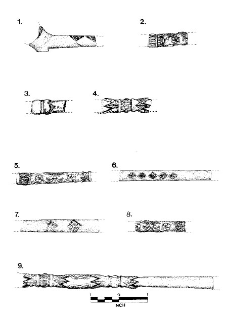 Figure 59. Decorated imported clay tobacco pipe stems.
Figure 59/9. Catalog Number 6106-44HT55-046.
Retrieved from Trash Pit G
This large fragment is decorated with raised floral motifs in the form of pointed leaves emanating from flattened knops. Interposed between the leaves, raised "peanut-shaped" designs appear with raised cross-hatching. The bore diameter of this Dutch fragment is 8/64"
Photo 48/12. Catalog Number 6208-44HT55-023.
Diameter of bowl mouth = 1.24 cm
Width of bowl = 2.7 cm
Height of bowl = 2.92 cm
EBC = 2.71 cu cm
SHD = 8/64"
Retrieved from Trash Pit B
This imported pipe bowl and stem fragment is stained a pale pinkish grey and carries no maker's mark. The lip of the bowl is decorated with a single rouletted line of square punctate marks below a down-tooled lip.
PART 2: CATALOG OF DOMESTIC TOBACCO PIPES
Figure 60/1. Catalog Number 6250-44HT55-008.
Diameter of Mouth = 1.68 cm
Width of bowl = 2.32 cm
Height of bowl = 3.66 cm
EBC = 3.69 cu cm
SHD = 6/64"
Munsell = 7.5YR7/8
Retrieved from Trash Pit B
This undecorated tobacco pipe bowl and stem shows evidence of tooth wear at the stem end. The clay has been worn away from the top and bottom surfaces, and one tooth indentation can be seen on the underside of the stem. The sides of the bowl flare outward from the bowl base to terminate with a flat lip.
Figure 60/2. Catalog Number 6251-44HT55-127.
Diameter of mouth = 1.86 cm
Width of bowl = 2.32 cm
Height of bowl—measurement not possible
EBC = 5.09 cu cm
SHD = 6/64"
Munsell = 7.5YR7/6
Retrieved from the well
This domestic pipe bowl was formed over a mandrel and had at least seven facets formed in the exterior surface. The facets flare evenly from the base to the lip, but are not themselves evenly spaced around the bowl body. The bowl curves gradually into the stem section which has not survived. This example is similar to Emerson's type 8 pipe bowl, except that this example exhibits facets running the full length of the bowl (Emerson 1988:88).
Figure 60/3. Catalog Number 6254-44HT55-050.
Diameter of bowl mouth = 2.61 cm
Width of bowl = 2.77 cm
Height of bowl = measurement not possible
EBC = measurement not possible
SHD = measurement not possible
Munsell = 7.5YR6/6
Retrieved from Trash Pit D
This large bowl fragment is unique among the HT55 tobacco pipe assemblage because of its shape. The broadest portion of the bowl is near the base which tapers gradually toward the flattened, squared-off mouth. The surfaces of the bowl have been smoothed and are well formed. Unfortunately, the base has been damaged, preventing any capacity measurements or any description of the stem area.
Figure 60/4. Catalog Number 6255-44HT55-050.
Diameter of bowl mouth = 1.34 cm
Width of bowl = 1.93 cm
Height of bowl = measurement not possible
EBC = measurement not possible
SHD = measurement not possible
Retrieved from Trash Pit D
Munsell = 10YR7/4
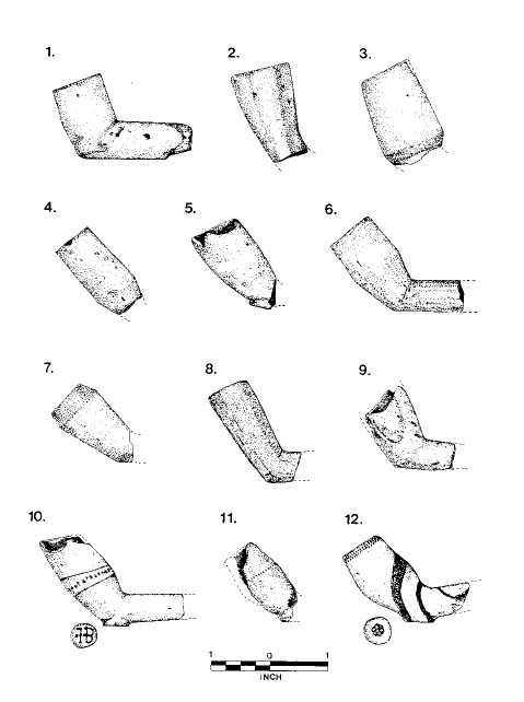 Figure 60. Domestic clay tobacco pipes.
228
Figure 60. Domestic clay tobacco pipes.
228
This undecorated pipe bowl is basically cylindrical from lip to near the base where it tapers toward the stem. Some irregularity in wall thickness is apparent in the bore and at the squared lip, which suggests that this example was not formed in a mold. The form of this example does not correspond to any recent typology.
Figure 60/5. Catalog Number 6256-44HT55-182.
Diameter of bowl mouth = 1.68 cm
Width of bowl = 2.07 cm
Height of bowl = 3.19 cm
EBC = measurement not possible
SHD = measurement not possible
Munsell = 7.5YR6/6
Retrieved from the well
This undecorated bowl is made of a tannish-salmon colored fine-grained clay, with areas of grey mottled clay throughout. The bowl exhibits curved surfaces and a round flat heel, similar in configuration to European bowls. The bowl lip has been damaged, preventing capacity or stem hole measurements; however, the presence of the heel suggests an obvious attempt to replicate European styles and form. Judging by the angle of the heel to the bowl and the manner of the fracture at the stem, it is believed that this bowl sat at an obtuse angle of approximately 150° to the stem.
Not Illustrated. Catalog Number 6257-44HT55-216.
Diameter of bowl mouth = 1.44 cm
Width of bowl = 2.34 cm
Height of bowl = 3.94 cm
EBC = 3.27 cu cm
SHD = 9/64"
Munsell = 10YR6/2
Retrieved from the well
Figure 60/6. Catalog Number 6258-44HT55-216.
Diameter of bowl mouth = 1.54 cm
Width of bowl = 2.28 cm
Height of bowl = 4.13 cm
EBC = 5.29 cu cm
SHD = 10/64"
Munsell = 7.5YR5/4
Retrieved from the well
These undecorated bowl and stem fragments are composed of a dull tannish colored clay with some grey mottling. The bowl shape is similar to type C of the Crass typology, but without the incised decoration (Crass 1988:90). The bowl, which rests at approximately a 130° angle to the stem, is cylindrical in the upper half, tapering to a heelless stem. These examples do not appear to have been mold-formed due to several irregularities in the surface and wall thickness of the bowls.
Figure 60/7. Catalog Number 6259-44HT55-050.
Diameter of bowl mouth = 1.41 cm
Width of bowl = 2.17 cm
Height of bowl = measurement not possible
EBC = 3.55 cu cm
SHD = 9/64"
Munsell = 7.5YR6/8
Retrieved from Trash Pit D
This undecorated bowl is irregular in wall thickness and surface treatment. The clay is a dull grayish-tan with some streaks of red running through a portion of the bowl wall. The bowl is cone-shaped, flaring from the base upward to angle inward to the lip. In form, this example is similar to Emerson's type 7, although this example is not as deep in the bowl and consequently is more angular (Emerson 1988:89).
Figure 60/8. Catalog Number 6262-44HT55-216.
Diameter of bowl mouth = 1.62 cm
Width of bowl = 1.94 cm
Height of bowl = 4.6 cm
EBC = measurement not possible
SHD = 9/64"
Munsell = 7.5YR7/4
Retrieved from the well
This heelless bowl and stem fragment is composed of a pale tan, fine-grained clay and is decorated with flared flat facets beginning at the stem and running upward to the squared lip. The octagonal section of the bowl shows a conical interior with well-formed walls.
Figure 60/9. Catalog Number 6291-44HT55-127.
Diameter of bowl mouth = measurement not possible
Width of bowl = measurement not possible
Height of bowl = measurement not possible
EBC = measurement not possible
SHD = 8/64"
Munsell = 7.5YR6/6
Retrieved from the well
This fragmentary bowl is composed of a reddish-brown clay with a small grit inclusion. The heelless bowl form corresponds to Emerson's type 1 (Emerson 1988:88).
Figure 60/10. Catalog Number 6265-44HT55-216.
Diameter of bowl mouth = approximately 1.6 cm
Width of bowl = 2.11 cm
Height of bowl = 3.89 cm
EBC = measurement not possible
SHD = 9/64"
Munsell = 10YR5/2
Retrieved from the well
This mold-formed pipe bowl is decorated with two lines of individually-incised lines at the lip and at the angle of the bowl. Above and below the angle band there appear two scratched lines which may have been incised into the pipe after its manufacture. The bowl tapers downward into the bowl base which has a flat, round heel which carries the maker's mark "I B." The letters are crudely-drawn incised lines with incised dots forming the serifs for the "I" and the "B." A single dot at the midpoint of the "I" may suggest a cross serif at this point suggesting the letter "J." Two additional dots, whose purpose is unknown, appear to the left of the "I." The maker is unknown.
Figure 60/11. Catalog Number 6268-44HT55-333.
Diameter of bowl mouth = measurement not possible
Width of bowl = 1.98 cm
Height of bowl = 3.16 cm
EBC = measurement not possible
230
SHD = 11/64"
Munsell = 7.5YR6/6
Retrieved from Feature 406, a posthole
This small bowl fragment is composed of mottled grayish to salmon-colored clay with one band of incised punctate marks. The marks appear to have been applied to the curved surface of the bowl with a five- or six-pointed linear stamp and run around the broadest part of the bowl. A portion of a broad flat heel survives at the base of the bowl which has individually-applied punctate marks at its circumference and an impressed maker's mark which appears to be a sun-burst motif. The maker is unknown.
Figure 60/12. Catalog Number 6271-44HT55-127.
Diameter of bowl mouth = approximately 1.57 cm
Width of bowl = measurement not possible
Height of bowl = 3.6 cm
EBC = measurement not possible
SHD = 10/64"
Munsell = 10YR7/4 (body), 10YR5/4 (slip)
Retrieved from the well
This mold-formed bowl and stem fragment is composed of a dull tannish, fine-grained clay which is soft and gritty. The bowl shape is similar to the type illustrated by Noël Hume in his 1970 study of tobacco pipe bowl shapes, with a suggested date range of 1645-1665 (I. Noël Hume 1970, as cited by Walker 1977:1547). This example differs from any other pipe in this study because of the double rouletted band of square punctate marks at the lip. The bowl exterior is decorated with a thin application of reddish brown slip which has been trailed over portions of the bowl and stem. The base of the bowl terminates in a broad flat heel with a maker's mark consisting of a six-lobed eglantine blossom incised into the heel surface. The maker is unknown.
Figure 61/1. Catalog 6004-44HT55-127.
Length of fragment = 6.26 cm
SHD = 10/64"
Munsell = 7.5YR6/6
Retrieved from the well
This fragmentary stem appears to have been decorated with individually-applied punctate marks which have been arranged in bands running around the stem, alternating with lines which intersect and form crosshatching.
Figure 61/2. Catalog Number 6280-44HT55-127.
Length of fragment = 3.24 cm
SHD = 9/64"
Munsell = 10YR7/6
Retrieved from the well
This stem fragment is similar to stem fragment 6004 in form of decoration. The punctate marks, which appear to have been applied with a roulette, form bands running around the stem and alternate with crosshatched lines. The incised decoration was originally heightened by the addition of a white chalk-like substance in each mark.
Figure 61/3. Catalog Number 6287-44HT55-050.
Length of fragment = 8.57 cm
SHD = 12/64"
Munsell = 7.5YR7/6
Retrieved from Trash Pit D
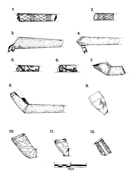 Figure 61. Domestic clay tobacco pipes.
This massive stem fragment, with by far the largest bore diameter of any pipe in this catalog, is composed of a fine- grained grayish-tan clay with no visible inclusion. The stem tapers sharply from one end to the other and displays a unique heel configuration. The fragmented heel appears to be a collar or carinated roll of clay that may have encircled the stem at the base of the bowl.
Figure 61/4. Catalog Number 6288-44HT55-085.
Length of fragment = 6.76 cm
SHD = 11/64"
Munsell = 2.5YR5/8
Retrieved from Trash Pit D
This unique stem and heel fragment is composed of a reddish-brown heterogeneous clay with small whitish-yellow clay inclusions. The surface of the stem has been burnished and is decorated with a stepped heel. The carved heel is square in section and consists of three superimposed pyramidal forms decreasing in size from the bowl base.
Figure 61/5. Catalog Number 6289-44HT55-182.
Length of fragment = 3.63 cm
SHD = 8/64"
Munsell = 10YR7/2 (body), 5YR3/4 (slip)
Retrieved from the well
This slip-decorated and rouletted stem fragment is composed of a hard, smooth grayish-brown clay with reddish- brown slip trailed in streaks around the stem. Two rouletted bands running around the stem consist of a series of closely-spaced parallel lines while the interposed band consists of alternating floral motifs and square grids. In addition, stylized floral blossoms are individually stamped into the stem surface.
Figure 61/6. Catalog Number 6290-44HT55-106.
Length of fragment = 3.06 cm
SHD = 10/64"
Munsell = 7.5YR8/2 (body), 5YR5/8 (slip)
Retrieved from Trash Pit E
This stem fragment is made of a soft, buff-colored clay which is decorated with a pale reddish-orange slip which has been trailed onto the surface. The rouletted decorations are worn and somewhat indistinct, but appear to be similar to those described above for example 6289. There are two bands of closely-spaced parallel lines running around the stem with a third band composed of alternating floral motifs and grids. The floral motifs appear to be more simplistic and stylized than in the previously described example.
Figure 61/7. Catalog Number 6277-44HT55-009.
Length of fragment = 5.1 cm
SHD = 8/64"
Munsell = 7.5YR6/6
Retrieved from Trash Pit A
This bowl and stem fragment is composed of a tannish-orange homogenous clay with rouletted decorations in the form of three encircling lines at the junction of the stem and bowl and triangular motifs around the bowl body. The punctate marks were originally heightened with the addition of a white chalk-like substance in each mark. The organization of the decorative elements around the bowl would suggest a symmetrical arrangement, but unfortunately not enough of the bowl survives to indicate the exact style (see Emerson 1988:79-107).
Figure 61/8. Catalog Number 6278-44HT55-069.
Diameter of bowl mouth = estimated 1.45 cm
Width of bowl = estimated 2.5 cm
Height of bowl = estimated 3.6 cm
EBC = measurement not possible
SHD = 10/64"
Munsell = 7.5YR6/6
Retrieved from Trash Pit F
This stem and bowl fragment is decorated with double rouletted lines of rhomboidal marks around the stem/bowl junction and below the squared lip. The incised decoration is heightened with a white chalk-like substance in each impression. The bowl, which has slightly curved sides, sets at approximately a 120° angle to the stem.
Figure 61/9. Catalog Number 6281-44HT55-182.
Diameter of bowl mouth = estimated 1.49 cm
Width of bowl = measurement not possible
Height of bowl = measurement not possible
Munsell = 2.5Y4/2
Retrieved from the well
This bowl fragment is made of a fine-grained clay which has been polished prior to decoration. The incised decoration consists of at least two zoomorphic images, referred to as the "running deer" by Emerson, who classifies this as type 5 (Emerson 1988:89). The bowl is encircled with two rouletted lines of square punctate marks running around the broadest part of the bowl.
Figure 61/10. Catalog Number 6279-44HT55-050.
Diameter of bowl mouth = 1.41 cm
Width of bowl = 2.28 cm
Height of bowl = estimated 3.81 cm
EBC = 4.04 cu cm
SHD = measurement not possible
Munsell = 10YR7/4
Retrieved from Trash Pit D
This bowl is made of a pale grayish-tan homogenous clay and has been decorated with interlocking and overlapping triangular designs formed with a toothed stamp. The lip of the bowl is beveled inward near the top and forms the broadest part of the bowl. The sides of the bowl are slightly curved, particularly at the base of the bowl near the stem elbow.
Figure 61/11. Catalog Number 6282-44HT55-177.
Munsell = 10YR6/2
Retrieved from the well
This bowl base fragment is decorated with two zoomorphic images similar to those described above in example 6281. These "running deer" images, however, are larger and more spontaneously incised than in the previous example (see Emerson 1988:89). The incised marks are filled with a white chalk-like substance to enhance the design. The surface of the pipe has been burnished and is a grayish-brown color.
Figure 61/12. Catalog Number 6283-44HT55-182.
Munsell = 10YR6/4
Retrieved from the well
This small bowl fragment is decorated with an unadorned vertical band flanked with three pairs of triangular motifs under a single rouletted line of rectangular dentulous impressions. All of the incised marks are heightened with a white chalk-like substance. The symmetry of this design, as contrasted with that shown in example 6279, suggests a higher degree of sophistication in artistic expression.
Appendix 3.
Faunal Data
236
TABLE 38.
NESP, MNI, AND POUNDS OF USABLE MEAT1
| NISP | MNI | Usable Meat | |||||
|---|---|---|---|---|---|---|---|
| No. | % | No. | % | Average Weight | Lbs | % | |
| CRUSTACEANS | |||||||
| Callinectes sapidus | 22 | 0.3 | 4 | 3.0 | 0.2 | 0.8 | <0.1 |
| 22 | 0.3 | 4 | 3.0 | 0.0 | 0.0 | 0.0 | |
| FISHES | |||||||
| Unidentified Fish | 1177 | 18.1 | 0 | 0.0 | 0.0 | 0.0 | 0.0 |
| Acipenser spp. | 1 | <0.1 | 1 | 0.8 | 100.0 | 100.0 | 1.4 |
| Felichthyes felis | 60 | 0.9 | 2 | 1.5 | 2.0 | 4.0 | 0.1 |
| Morone saxatilis | 7 | 0.1 | 2 | 1.5 | 7.5 | 15.0 | 0.2 |
| Family Sparidae | 1 | <0.1 | 0 | 0.0 | 1.0 | 1.0 | <0.1 |
| cf. Family Sparidae | 1 | <0.1 | 0 | 0.0 | 0.0 | 0.0 | 0.0 |
| Archosargus probatocephalus | 24 | 0.4 | 3 | 2.3 | 7.5 | 22.5 | 0.3 |
| Pogonias cromis | 92 | 1.4 | 4 | 3.1 | 25.0 | 100.0 | 1.4 |
| Sciaenops ocellatus | 22 | 0.3 | 3 | 2.3 | 18.0 | 54.0 | 0.7 |
| cf. Sciaenops ocellatus | 1 | <0.1 | 0 | 0.0 | 0.0 | 0.0 | 0.0 |
| Micropogon undulatus | 48 | 0.7 | 3 | 2.3 | 1.0 | 3.0 | <0.1 |
| Cynoscion spp. | 9 | 0.8 | 1 | 0.8 | 5.0 | 5.0 | 0.1 |
| Carcharhinus spp. | 1 | <0.1 | 1 | 0.8 | 10.0 | 10.0 | 0.1 |
| 1444 | 22.2 | 20 | 15.2 | 0.0 | 314.5 | 4.4 | |
| AMPHIBIANS | |||||||
| cf. Bufo spp. | 1 | <0.1 | 1 | 0.8 | 0.0 | 0.0 | 0.0 |
| Rana spp. | 647 | 9.9 | 12 | 9.1 | 0.0 | 0.0 | 0.0 |
| 648 | 10.0 | 13 | 9.8 | 0.0 | 0.0 | 0.0 | |
| REPTILES | |||||||
| Sternotherus odoratus | 4 | 0.1 | 1 | 0.8 | 0.4 | 0.4 | <0.1 |
| Kinosternon subrubrum | 1 | <0.1 | 1 | 0.8 | 0.4 | 0.4 | <0.1 |
| Pseudemys spp. | 2 | <0.1 | 1 | 0.8 | 3.0 | 3.0 | <0.1 |
| Malaclemys terrapin | 25 | 0.4 | 2 | 1.6 | 0.6 | 1.2 | <0.1 |
| Order Squamata | 2 | <0.1 | 0 | 0.0 | 0.0 | 0.0 | 0.0 |
| Family Colubridae | 1 | <0.1 | 0 | 0.0 | 0.0 | 0.0 | 0.0 |
| Elaphe guttata | 1 | <0.1 | 1 | 0.8 | 0.0 | 0.0 | 0.0 |
| Thamnophis sirtalis | 2 | <0.1 | 1 | 0.8 | 0.0 | 0.0 | 0.0 |
| cf. Thamnophis sirtalis | 1 | <0.1 | 0 | 0.0 | 0.0 | 0.0 | 0.0 |
| Crotalus horridus | 1 | <0.1 | 1 | 0.8 | 0.0 | 0.0 | 0.0 |
| 40 | 0.6 | 8 | 6.1 | 4.4 | 5.0 | <0.1 | |
| BIRDS | |||||||
| Unidentified Bird | 228 | 3.5 | 0 | 0.0 | 0.0 | 0.0 | 0.0 |
| Undientifed Bird/Sm Mammal | 8 | 0.1 | 0 | 0.0 | 0.0 | 0.0 | 0.0 |
| Ardea herodias | 2 | <0.1 | 1 | 0.8 | 10.0 | 10.0 | 0.1 |
| Gavia immer | 1 | <0.1 | 1 | 0.8 | 4.0 | 4.0 | 0.1 |
| Phalacrocorax auritus | 2 | <0.1 | 1 | 0.8 | 5.0 | 5.0 | 0.1 |
| 238 | |||||||
| Phalacrocorax spp. | 2 | <0.1 | 0 | 0.0 | 0.0 | 0.0 | 0.0 |
| Cygnus columbianus | 1 | <0.1 | 1 | 0.8 | 10.0 | 10.0 | 0.1 |
| Anser spp. | 4 | 0.1 | 0 | 0.0 | 0.0 | 0.0 | 0.0 |
| cf. Anser spp. | 1 | <0.1 | 0 | 0.0 | 0.0 | 0.0 | 0.0 |
| Anser anser | 12 | 0.2 | 1/22 | 2.3 | 6.0 | 18.0 | 0.2 |
| cf. Anser anser | 3 | <0.1 | 0 | 0.0 | 0.0 | 0.0 | 0.0 |
| Branta canadensis | 2 | <0.1 | 1 | 0.8 | 6.0 | 6.0 | 0.1 |
| Anas platyrhynchos | 14 | 0.2 | 2 | 1.6 | 2.0 | 4.0 | 0.1 |
| cf. Anas platyrhynchos | 5 | 0.1 | 0 | 0.0 | 0.0 | 0.0 | 0.0 |
| Aythya spp. | 5 | 0.1 | 1 | 0.8 | 1.0 | 1.0 | <0.1 |
| Gallinago gallinago | 1 | <0.1 | 1 | 0.8 | 1.0 | 1.0 | <0.1 |
| Family Phasianidae | 25 | 0.4 | 0 | 0.0 | 0.0 | 0.0 | 0.0 |
| cf. Family Phasianidae | 7 | 0.1 | 0 | 0.0 | 0.0 | 0.0 | 0.0 |
| Meleagris gallopavo | 2 | <0.1 | 1 | 0.8 | 7.5 | 7.5 | 0.1 |
| cf. Meleagris gallopavo | 1 | <0.1 | 0 | 0.0 | 0.0 | 0.0 | 0.0 |
| Gallus gallus | 235 | 3.6 | 10/3 | 9.8 | 0.53 | 20.0 | 0.3 |
| cf. Gallus gallus | 10 | 0.2 | 0 | 0.0 | 0.0 | 0.0 | 0.0 |
| cf. Colinus virginianus | 1 | <0.1 | 1 | 0.8 | 0.5 | 0.5 | <0.1 |
| Bonasa umbellus | 1 | <0.1 | 1 | 0.8 | 0.5 | 0.5 | <0.1 |
| Ectopistes migratorius | 1 | <0.1 | 1 | 0.8 | 0.5 | 0.5 | <0.1 |
| cf. Ectopistes migratorius | 1 | <0.1 | 0 | 0.0 | 0.0 | 0.0 | 0.0 |
| cf. Turdus migratorius | 1 | <0.1 | 1 | 0.8 | 0.0 | 0.0 | 0.0 |
| 576 | 8.9 | 30 | 22.7 | 0.0 | 88.0 | 1.2 | |
| MAMMALS | |||||||
| Unidentified Mammal | 377 | 5.8 | 0 | 0.0 | 0.0 | 0.0 | 0.0 |
| Unidentifed Large Mammal | 338 | 5.2 | 0 | 0.0 | 0.0 | 0.0 | 0.0 |
| cf. Unidentified Large Mammal | 7 | 0.1 | 0 | 0.0 | 0.0 | 0.0 | 0.0 |
| Unidentified Medium Mammal | 772 | 11.9 | 0 | 0.0 | 0.0 | 0.0 | 0.0 |
| Unidentified Small Mammal | 17 | 0.3 | 0 | 0.0 | 0.0 | 0.0 | 0.0 |
| Didelphis virginiana | 3 | <0.1 | 1 | 0.8 | 8.0 | 8.0 | 0.1 |
| cf. Didelphis virginiana | 2 | <0.1 | 0 | 0.0 | 0.0 | 0.0 | 0.0 |
| Sylvilagus floridanus | 5 | 0.1 | 1 | 0.8 | 2.0 | 2.0 | <0.1 |
| Order Rodentia | 6 | 0.1 | 0 | 0.0 | 0.0 | 0.0 | 0.0 |
| Sciurus carolinensis | 16 | 0.2 | 2 | 1.6 | 1.0 | 2.0 | <0.1 |
| cf. Sciurus carolinensis | 2 | <0.1 | 0 | 0.0 | 0.0 | 0.0 | 0.0 |
| Sciurus niger | 6 | 0.1 | 1 | 0.8 | 0.8 | 0.8 | 0.1 |
| Castor canadensis | 2 | <0.1 | 1 | 0.8 | 25.0 | 25.0 | 0.3 |
| cf. Sigmodon hispidus | 1 | <0.1 | 1 | 0.8 | 0.0 | 0.0 | 0.0 |
| Order Carnivora | 4 | 0.1 | 0 | 0.0 | 0.0 | 0.0 | 0.0 |
| Canis spp. | 3 | 0.1 | 1 | 0.8 | 0.0 | 0.0 | 0.0 |
| Procyon lotor | 4 | 0.1 | 1 | 0.8 | 15.0 | 15.0 | 0.2 |
| Felis domesticus | 6 | 0.1 | 2 | 1.6 | 0.0 | 0.0 | 0.0 |
| cf. Felis domesticus | 7 | 0.1 | 0 | 0.0 | 0.0 | 0.0 | 0.0 |
| Equus spp. | 1 | <0.1 | 1 | 0.8 | 0.0 | 0.0 | 0.0 |
| 239 | |||||||
| Order Artiodactyla I | 68 | 1.0 | 0 | 0.0 | 0.0 | 0.0 | 0.0 |
| cf. Order Artiodactyla I | 1 | <0.1 | 0 | 0.0 | 0.0 | 0.0 | 0.0 |
| Order Artiodactyla II | 31 | 0.5 | 0 | 0.0 | 0.0 | 0.0 | 0.0 |
| cf. Order Artiodactyla II | 2 | <0.1 | 0 | 0.0 | 0.0 | 0.0 | 0.0 |
| Sus scrofa | 629 | 9.7 | 17/42 | 15.9 | 100.04 | 1900.0 | 26.4 |
| cf. Sus scrofa | 21 | 0.3 | 0 | 0.0 | 0.0 | 0.0 | 0.0 |
| Odocoileus virginianus | 73 | 1.1 | 5 | 3.8 | 100.0 | 500.0 | 6.9 |
| cf. Odocoileus virginianus | 10 | 0.2 | 0 | 0.0 | 0.0 | 0.0 | 0.0 |
| Bos taurus/Equus spp. | 16 | 0.2 | 0 | 0.0 | 0.0 | 0.0 | 0.0 |
| cf. Bos taurus/Equus spp. | 3 | <0.1 | 0 | 0.0 | 0.0 | 0.0 | 0.0 |
| Bos taurus | 1190 | 18.3 | 10/32 | 9.8 | 400.05 | 4150.0 | 57.6 |
| cf. Bos taurus | 60 | 0.9 | 0 | 0.0 | 0.0 | 0.0 | 0.0 |
| Ovis aries/Capra hircus | 85 | 1.3 | 5/12 | 4.5 | 35.06 | 190.0 | 2.6 |
| cf. Ovis aries/Capra hircus | 9 | 0.1 | 0 | 0.0 | 0.0 | 0.0 | 0.0 |
| cf. Capra hircus | 1 | <0.1 | 0 | 0.0 | 0.0 | 0.0 | 0.0 |
| 3778 | 58.1 | 57 | 43.2 | 0.0 | 6792.8 | 94.3 | |
| TOTAL | 6508 | 100.0 | 132 | 100.0 | 0.0 | 7201.1 | 100.0 |
TABLE 39.
BIOMASS
| No. | Biomass (Kg) | % | |
|---|---|---|---|
| CRUSTACEANS | |||
| Callinectes sapidus | 22 | <0.01 | <0.1 |
| FISHES | |||
| Unidentified Fish | 1177 | 3.63 | 1.0 |
| Acipenser spp. | 1 | 0.01 | <0.1 |
| Felichthyes felis | 60 | 0.53 | 0.1 |
| Morone saxatilis | 7 | 0.02 | <0.1 |
| Family Sparidae | 1 | 0.01 | <0.1 |
| cf. Family Sparidae | 1 | <0.01 | <0.1 |
| Archosargus probatocephalus | 24 | 0.29 | 0.1 |
| Pogonias cromis | 92 | 2.24 | 0.6 |
| Sciaenops ocellatus | 22 | 0.41 | 0.1 |
| cf. Sciaenops ocellatus | 1 | 0.06 | <0.1 |
| Micropogon undulatus | 48 | 0.18 | <0.1 |
| Cynoscion spp. | 9 | 0.05 | <0.1 |
| Carcharhinus spp. | 1 | 0.23 | 0.1 |
| AMPHIBIANS | |||
| cf. Bufo spp. | 1 | 0.01 | <0.1 |
| Rana spp. | 647 | 0.12 | <0.1 |
| REPTILES | |||
| Sternotherus odoratus | 4 | 0.05 | <0.1 |
| Kinosternon subrubrum | 1 | 0.01 | <0.1 |
| Pseudemys spp. | 2 | 0.04 | <0.1 |
| Malaclemys terrapin | 25 | 0.60 | 0.2 |
| Order Squamata | 2 | <0.01 | <0.1 |
| Family Colubridae | 1 | <0.01 | <0.1 |
| Elaphe guttata | 1 | <0.01 | <0.1 |
| Thamnophis sirtalis | 2 | <0.01 | <0.1 |
| cf. Thamnophis sirtalis | 1 | <0.01 | <0.1 |
| Crotalus horridus | 1 | <0.01 | <0.1 |
| BIRDS | |||
| Unidentified Bird | 228 | 1.06 | 0.3 |
| Undientifed Bird/Sm Mammal | 8 | 0.07 | <0.1 |
| Ardea herodias | 2 | 0.12 | <0.1 |
| Gavia immer | 1 | 0.02 | <0.1 |
| Phalacrocorax spp. | 2 | 0.03 | <0.1 |
| Phalacrocorax auritus | 2 | 0.07 | <0.1 |
| Cygnus columbianus | 1 | 0.03 | <0.1 |
| Anser spp. | 4 | 0.09 | <0.1 |
| cf. Anser spp. | 1 | 0.02 | <0.1 |
| Anser anser | 12 | 0.45 | 0.1 |
| cf. Anser anser | 3 | 0.08 | <0.1 |
| Branta canadensis | 2 | 0.03 | <0.1 |
| 241 | |||
| Anas platyrhynchos | 14 | 0.12 | <0.1 |
| cf. Anas platyrhynchos | 5 | 0.03 | <0.1 |
| Aythya spp. | 5 | 0.09 | <0.1 |
| Gallinago gallinago | 1 | <0.01 | <0.1 |
| Family Phasianidae | 25 | 0.23 | 0.1 |
| cf. Family Phasianidae | 7 | 0.05 | <0.1 |
| Meleagris gallopavo | 2 | 0.02 | <0.1 |
| cf. Meleagris gallopavo | 1 | 0.06 | <0.1 |
| Gallus gallus | 235 | 2.76 | 0.8 |
| cf. Gallus gallus | 10 | 0.07 | <0.1 |
| cf. Colinus virginianus | 1 | <0.01 | <0.1 |
| Bonasa umbellus | 1 | <0.01 | <0.1 |
| Ectopistes migratorius | 1 | <0.01 | <0.1 |
| cf. Ectopistes migratorius | 1 | <0.01 | <0.1 |
| cf. Turdus migratorius | 1 | <0.01 | <0.1 |
| MAMMALS | |||
| Unidentified Mammal | 377 | 8.78 | 2.4 |
| Unidentifed Large Mammal | 338 | 37.26 | 10.2 |
| cf. Unidentified Large Mammal | 7 | 1.70 | 0.5 |
| Unidentified Medium Mammal | 772 | 19.50 | 5.3 |
| Unidentified Small Mammal | 17 | 0.14 | <0.1 |
| Didelphis virginiana | 3 | 0.04 | <0.1 |
| cf. Didelphis virginiana | 2 | 0.04 | <0.1 |
| Sylvilagus floridanus | 5 | 0.06 | <0.1 |
| Order Rodentia | 6 | 0.04 | <0.1 |
| Sciurus carolinensis | 16 | 0.17 | <0.1 |
| cf. Sciurus carolinensis | 2 | 0.02 | <0.1 |
| Sciurus niger | 6 | 0.08 | <0.1 |
| Castor canadensis | 2 | 0.06 | <0.1 |
| cf. Sigmodon hispidus | 1 | <0.01 | <0.1 |
| Order Carnivora | 4 | 0.03 | <0.1 |
| Canis spp. | 3 | 0.22 | 0.1 |
| Procyon lotor | 4 | 0.18 | <0.1 |
| Felis domesticus | 6 | 0.19 | 0.1 |
| cf. Felis domesticus | 7 | 0.12 | <0.1 |
| Equus spp. | 1 | 0.17 | <0.1 |
| Order Artiodactyla I | 68 | 2.09 | 0.6 |
| cf. Order Artiodactyla I | 1 | 0.14 | <0.1 |
| Order Artiodactyla II | 31 | 1.70 | 0.5 |
| cf. Order Artiodactyla II | 2 | 0.13 | <0.1 |
| Sus scrofa | 629 | 49.55 | 13.5 |
| cf. Sus scrofa | 21 | 0.96 | 0.3 |
| Odocoileus virginianus | 73 | 12.42 | 3.4 |
| cf. Odocoileus virginianus | 10 | 0.82 | 0.2 |
| Bos taurus/Equus spp. | 16 | 3.97 | 1.1 |
| cf. Bos taurus/Equus spp. | 3 | 1.16 | 0.3 |
| 242 | |||
| Bos taurus | 1190 | 220.73 | 60.3 |
| cf. Bos taurus | 60 | 6.96 | 1.9 |
| Ovis aries/Capra hircus | 85 | 13.74 | 3.8 |
| cf. Ovis aries/Capra hircus | 9 | 0.70 | 0.2 |
| cf. Capra hircus | 1 | 0.42 | 0.1 |
| TOTAL | 6508 | 365.90 | 100.0 |
TABLE 40.
AGE DISTRIBUTION FOR DOMESTIC PIG
| Bone and Epiphysis | Fused | Not Fused |
|---|---|---|
| Radius - proximal | 3 | 2 |
| Humerus - distal | 2 | 3 |
| Second phalange - proximal | 1 | 8 |
| Scapula | 1 | 1 |
| 7 | 14 | |
| Percent of Age Range | 33.3% | 66.7% |
| Bone and Epiphysis | Fused | Not Fused |
|---|---|---|
| Metacarpal - distal | 1 | 1 |
| First phalange - proximal | 0 | 0 |
| Tibia - distal | 3 | 3 |
| Metatarsal - distal | 1 | 5 |
| Calcaneus | 0 | 4 |
| Fibula - distal | 0 | 1 |
| Metapodial - distal | 0 | 13 |
| 5 | 27 | |
| Percent of Age Range | 15.6% | 84.4% |
| Bone and Epiphysis | Fused | Not Fused |
|---|---|---|
| Ulna - proximal and distal | 0 | 2 |
| Humerus - proximal | 0 | 2 |
| Radius - distal | 0 | 2 |
| Femur - proximal and distal | 1 | 8 |
| 1 | 14 | |
| Percent of Age Range | 6.7% | 93.3% |
TABLE 41.
AGE DISTRIBUTION FOR DOMESTIC COW
| Bone and Epiphysis | Fused | Not Fused |
|---|---|---|
| Scapula | 6 | 0 |
| Humerus - distal | 5 | 0 |
| Radius - proximal | 6 | 1 |
| First Phalange - proximal | 0 | 0 |
| Second Phalange - proximal | 30 | 0 |
| 47 | 1 | |
| Percent of Age Range | 97.9% | 2.1% |
| Bone and Epiphysis | Fused | Not Fused |
|---|---|---|
| Metacarpal - distal | 11 | 5 |
| Tibia - distal | 7 | 2 |
| Metatarsal - distal | 7 | 1 |
| Calcaneus | 2 | 2 |
| Metapodial - distal | 0 | 3 |
| 27 | 13 | |
| Percent of Age Range | 67.5% | 32.5% |
| Bone and Epiphysis | Fused | Not Fused |
|---|---|---|
| Radius - distal | 2 | 0 |
| Ulna - proximal and distal | 2 | 2 |
| Femur - proximal | 0 | 2 |
| Femur - distal | 1 | 2 |
| Tibia - proximal | 1 | 2 |
| Humerus - proximal | 0 | 2 |
| 6 | 10 | |
| Percent of Age Range | 37.5% | 62.5% |
TABLE 42.
AGE DISTRIBUTION FOR DOMESTIC SHEEP/GOAT
| Bone and Epiphysis | Fused | Not Fused |
|---|---|---|
| Scapula | 2 | 0 |
| Humerus - distal | 1 | 0 |
| Radius - proximal | 0 | 0 |
| First Phalange - proximal and distal | 0 | 0 |
| Second Phalange - distal | 0 | 0 |
| 3 | 0 | |
| Percent of Age Range | 100.0% | 0.0% |
| Bone and Epiphysis | Fused | Not Fused |
|---|---|---|
| Ulna - proximal and distal | 0 | 0 |
| Metacarpal - distal | 1 | 0 |
| Metatarsal - distal | 1 | 0 |
| Metapodial - distal | 0 | 0 |
| Tibia - distal | 2 | 0 |
| 4 | 0 | |
| Percent of Age Range | 100.0% | 0.0% |
| Bone and Epiphysis | Fused Not | Fused |
|---|---|---|
| Humerus - proximal | 0 | 0 |
| Radius - distal | 0 | 0 |
| Calcaneus | 1 | 0 |
| Femur - proximal and distal | 0 | 0 |
| Tibia - proximal | 0 | 0 |
| 1 | 0 | |
| Percent of Age Range | 100.0% | 0.0% |
Appendix 4.
Data Recovery Plan
I. Introduction
Between July 9 and September 8, 1987, the Tidewater Cultural Resource Center of the College of William and Mary conducted a combined Phase I and Phase II archaeological investigation of an approximately sixteen acre parcel adjacent to the campus of Hampton University. The University owns the property and is acting as the developer of a commercial and residential project known as Pirate's Cove. The purpose of the investigation was to assess the National Register status of one known archaeological site on the property, a seventeenth century domestic complex recorded in 1979 as 44 HT 55, and to identify and evaluate other possible sites on the parcel. This document summarizes the results of the Phase I and Phase II study, describes the research potential of the sites identified on the parcel, and provides a plan for fieldwork and analysis that addresses these research values.
II. Summary of Past Work
The majority of the parcel has been in cultivation for many years. In 1979, the plowed field was surveyed by Howard MacCord for the Virginia Department of Highways and Transportation (see attached survey form). This survey was conducted as part of examining the right-of-way of a new extension of state highway 143. MacCord did no actual excavation, but identified the seventeenth century domestic site on the basis of a sample of imported and locally-made clay smoking pipes and a few fragments of tin-enameled earthenware and Rhenish stoneware. Based on this material, MacCord attributed the site to the third quarter of the seventeenth century.
MacCord's walkover survey also produced concentrations of nineteenth and early twentieth century artifacts, and a more dispersed scatter of prehistoric materials dating to the late Archaic and Early Woodland periods. None of these finds resulted in the recording of additional discrete sites.
The parcel was again examined in 1980 by Mark Wittkofski, staff archaeologist with the Virginia Division of Historic Landmarks. He did some limited subsurface testing within the area of site 44 HT 55, and found two features, a narrow trench identified as support for a paling fence, and another wider trench. Wittkofski concluded that A phase three excavation will be required for 44 HT 55 if it becomes threatened by any construction. Limited testing indicated the site had good preservation of subsurface cultural features. Since much of Hampton has been heavily urbanized, this site could provide important information concerning the changes which took place in the lower Tidewater region (1980:6).
Construction of the Rt. 143 extension and interchange did not impact 44 HT 55, and the site was left undisturbed until early in the summer of this year. Knowing of the site's existence, Hampton University officials arranged with the local chapter of the Archaeological Society of Virginia to further examine site 44 HT 55 and salvage any significant remains prior to development of Pirate's Cove.
The Kicotan Chapter of the Archeological Society of Virginia began their investigation of site 44 HT 55 by excavating a number of test trenches in the plowed field. Almost immediately they encountered a brick-lined cellar. Other trenching in the vicinity of the cellar revealed several features which, along with the cellar, were partially excavated by the local chapter.After these discoveries were made known, Hampton University officials sought professional advice.
The Tidewater Cultural Resource Center at the College of William and Mary was consulted and the discoveries made by the Kicotan chapter of the A.S.V. were reviewed in the field. 248 Discussion with Hampton University officials indicated the possibility that the University might use grant funds from the United States Department of Housing and Urban Development to help finance the project. In view of the recommendations of the 1980 report, therefore, the Center recommended that proper Phase II investigation of HT55 be undertaken concurrently with a combined Phase I and Phase II of the entire development parcel. The T.C.R.C. completed this work in mid-September as part of a cooperative agreement with the University.
III. Results of Survey and Site Examination
44 HT 55
Investigation of HT55 was facilitated by the mechanical removal of plowzone from around the cellar area and in several large test trenches placed between the cellar and the Hampton River (see Fig. 1). Identified features were carefully exposed in plan and recorded on a base map and photographed. No excavation of features was undertaken, as an existing sample of artifacts from the A.S.V. chapter excavation confirmed the original estimate of site age provided by MacCord in 1979. Machine-excavated trenches established the perimeter boundaries of the seventeenth century domestic complex.
Site examination revealed that the brick-lined and tile-floored cellar is part of an earth-fast building measuring approximately 16 by 32 feet, oriented in an east-west direction. Test excavation also located at least three large refuse pits, a possible root cellar, two small post structures, and numerous post holes representing other earth-fast buildings or fence lines (Fig. 2). The areal of extent of site 44 HT 55 covers approximately forty thousand square feet.
Artifacts recovered by the Kicotan Chapter during the cellar excavation and from trenching in the area were similar to those collected from the surface of the plowzone by Howard MacCord in 1979. They include fragments of tin-enameled earthenware, Rhenish stoneware, red-bodied earthenwares, case bottle glass, and both locally-made and imported clay smoking pipes. These materials indicate that the cellar was probably filled in during the third quarter of the seventeenth century. No structural features have been excavated at this time, so a construction date for the house has not yet been determined.
Phase II examination of 44 HT 55 revealed a well-preserved structural complex consisting of brick cellar (Fig. 3) that is part of a large earthfast dwelling house, associated earthfast outbuildings, and other features and trash disposal areas possibly related to craft and other productive activities. The precise spatial layout, function, and chronological position of these various remains can only be determined through full-scale excavation, but the evidence at hand confirms the original 1979 identification of the site and reaffirms the 1980 evaluation of the site's importance.
In terms of the historical identification of this domestic complex, there is some evidence to suggest that the site was part of the holdings of the second church of the Elizabeth City Parish, on property referred to in surviving deeds as the "gleab lands." It is therefore possible that the domestic and agricultural complex belonged to the parish, being used as housing for the parish minister, as income-producing agricultural land, or both.
There is some confusion about when a parish church was established on the eastern side of Southampton River. A recent study of the physical remains of this structure, now referred to as the "Second Church of Elizabeth City Parish," argues that it was built as early as 1624 (Holt 1985). Another local historian, however, has demonstrated that the first firm documentation of a church on the east side does not occur until 1637 (UAJV 1983; Nugent 1979: 76).
These conflicting accounts of when the parish church was established on the east side of the Southampton River must be further reconciled with the evidence that Jonas Stockton, one of the early ministers of the Elizabeth City Parish, leased land on the east side of the river as early as 1627 249 (Nugent 1979:9). Stockton's leasehold was located on property that once belonged to a large tract of some fifteen hundred acres of common land reserved for the Virginia Company.
Stockton's property is described as bounded on the south by the creek (Jones) separating it from "Indian Thickett", on the north by "another creek", on the east by the main woods, and on the west by the river. Although Stockton died in the summer of the next year, the parcel of land he leased is apparently referred to as "the gleab land" for many years afterward. The description of this holding places it adjacent to the Second Church site, although the legal relation between the two is still unclear.
Apparently, the Second Church was in use until about 1667. By that time there was a new church on the west side of the river, perhaps indicating a shift in the population center (U.A.J.V. 1983). The church, and perhaps major structures located on 44 HT 55 for that matter, may have been irreparably damaged or totally destroyed by a Category Three hurricane that struck the area on September 6, 1667. According to some accounts, 10,000 houses were destroyed in Virginia by this devastating hurricane (Holt 1985:190).
Only additional research in the primary sources relating to the seventeenth century settlement of Elizabeth City County will clarify the historical context of site 44 HT 55. There is evidence, however, that it was somehow related to the site of the Second Church, perhaps serving as housing for the parish minister, or as a tenant plantation on the parish glebe lands. Historical information also suggests that indications of severe damage to the site may be encountered, corresponding to the ravages of the 1667 hurricane.
44 HT 36 and 44 HT 37
The remainder of the Pirate's Cove project area of approximately twenty-one acres was examined using large test trenches. These trenches were excavated stratigraphically by a grading machine with a five-foot wide flat bucket. On the west side of the R.O.T.C. road, twenty-nine test units, ranging in size from five feet wide and twenty feet long to ten feet wide and sixty feet in length were placed throughout the field (Fig. 1). Test trenches were placed according to the surface characteristics of the plowed field, soil color, and the results of systematic surface collection. Several test trenches were also randomly placed. These test excavations revealed no significant subsurface features in any part of the field other than within the area identified with 44 HT 55.
These negative results are interesting in view of the results of MacCord's 1979 surface collection of the same property. He found six concentrations of recent material, as well as scattered prehistoric evidence. Test excavation in his areas of nineteenth and early twentieth century artifact concentrations failed to produce structural remains. Test excavation also failed to produce features or other evidence of prehistoric occupation.
On the eastern side of the R.O.T.C. road, a total of sixty-one five by ten foot test trenches were excavated in a field of approximately seven acres (Fig. 4). This field had never before been examined for archaeological remains. Within most of the field, testing revealed only a few widely dispersed features and artifact scatters, including two trenches of apparent modern origin, a modern east-west fenceline, and some scattered fragments of unidentifiable prehistoric pottery. Units placed in one area of the R.O.T.C. field, however, produced evidence of substantial subsurface features associated with prehistoric occupation in the area. Additional test trenching on the west side of R.O.T.C. drive, adjacent to the University Infirmary, encountered similar features (Fig. 5).
Beginning approximately one hundred and seventy-five feet south of the R.O.T.C. building, test trenching uncovered several large pits, over three feet in diameter, and three to five feet in depth (44 HT 36). These pits contained large amounts of Middle Woodland pottery of the Mockley type (Figs. 6 & 7). Unlike the scattered prehistoric materials found in several other test units, these features are well-preserved and are 250 concentrated in an area of about twenty thousand square feet bounded on the north by the R.O.T.C. building and on the west by R.O.T.C. Drive. They appear to be part of a Middle Woodland base camp.
A group of similar pit features were encountered in test trenches excavated across R.O.T.C. drive in the area adjacent to the infirmary ( 44 HT 37; see Fig. 8). Only one of these features was sampled and it, too, contained fragments of Mockley type pottery. Although it is possible that these pits relate to the features found across the street, they have been initially identified as belonging to a separate base camp, perhaps occupied during a different phase of the Middle Woodland Period. These prehistoric remains have been assigned two separate site numbers, although subsequent work may show they are part of the same site complex (see accompanying site forms).
IV. Site Significance
These historic and prehistoric sites are located within the Pirate's Cove project area, a development on the property of Hampton University that has received grant assistance from the United States Department of Housing and Urban Development. As a result, their significance needs to be assessed in terms of the criteria for eligibility to the National Register of Historic Places. As archaeological properties, these sites take on their importance primarily in light of the character and quality of the information they contain. The value of this information is, in turn, related to the contribution it can make to studying broad patterns and processes of historical and cultural development. These attributes of significance reflect the first and fourth of the National Register criteria.
Evaluating the research potential of these sites is thus a matter of identifying the relevant historical and cultural patterns and processes to which they relate, and specifying the categories of archaeological data recoverable from them which will help to understand these events and developments. The comprehensive historic preservation plan for the area that includes most of the James-York peninsula provides the intellectual and procedural framework for this evaluation (Brown and Bragdon 1986). This plan identifies several study units or historic contexts that provide an appropriate framework for assessing the significance of these sites.
Woodland Base Camps—44 HT 36 and 44 HT 37
The historic context that is most relevant to the Middle Woodland sites is Study Unit III, which describes general cultural development on the Peninsula during the period 2000 B.C. to 1000 A.D. Following the work of Jay Custer in Delaware, this study unit spans the periods traditionally separated as the Late Archaic and the Early and Middle Woodland. It considers these periods as one general stage in the prehistoric development of the region, emphasizing the appearance and persistence of estuarine and riverine adaptations that support large "macroband" base camps whose populations appear significantly larger than those occupying base camps during the Archaic period. This trend serves as the central theme of Study Unit III; which is, "sedentary lifestyles and the development of regional adaptations in response to distinctive marine environments of the James-York Peninsula" (Hunter 1986).
The second Study Unit applicable to the study of the prehistoric components encompasses the traditionally-defined Late Woodland period (1000 A.D. - 1560 A.D.). The subsistence and social practices that evolved during the period are those described by the early European explorers. Both the ethnohistorical and archaeological data has shown that during this period, an increasing dependence upon agriculture, especially the cultivation of maize took place, and that social organization revolved around the appearance of well-established villages.
Within these study units, specific research themes are also identified. These emphasize the analysis of ceramic technology and its cultural implications, the study of seasonality as it affected 251 food resources, settlement pattern, and social organization, and the investigation of social and cultural interaction on a regional level. The preservation plan for the James-York peninsula identifies two basic site types associated with the period, base camps and procurement sites. The base camps are primarily found in estuarine and riverine settings, and are usually multi-component in nature, representing long-term seasonal or year-around occupation. They have usually been disturbed by plowing and many have been lost to coastal erosion (Hunter 1986:55-57).
Even though there has been a bias in past prehistoric research on the Peninsula, in favor of the excavation of base camps as opposed to the investigation of more interior, procurement sites, the preservation plan makes it clear that very little is known about either of these site types. Limited excavation of base camps dating from the Late Archaic through the Middle Woodland has been accomplished in only a few instances, and these have been sites associated with large coastal shell middens. Very little is known about the actual content and structure of these sites. Much work remains to be done in refining local chronologies; questions regarding variability in seasonality, settlement pattern, and group size, and trade and exchange have yet to be meaningfully addressed on the Peninsula. As a result, comparison of the Peninsula's cultural history during this period with other areas of the Coastal Plain is difficult at best.
It would be difficult as well, however, to overestimate the significance of these sites. Although they have been subject to repeated plowing, potentially destroying direct evidence of midden accumulation and prehistoric shelters and other structures, the existence of numerous, virtually undisturbed storage pits concentrated in these two areas has potential significance along several avenues of comparative investigation:
Culture History: Although the general outlines of the area's cultural history are known, no refinement of the local chronology has yet been attempted. Partial excavation of the several of the pit features has yielded excellent samples of wood charcoal suitable for radiocarbon dating. The absolute dating of these features will anchor the investigation of the general issues discussed below.
Ceramic Analysis: Recent archaeological study of the Powhatan Creek drainage near Williamsburg has refined the range and variation of known ceramic types from that portion of the James-York Peninsula (Hodges 1987). Consequently, a well-established framework is available in which the view the ceramics recovered from the Hampton University sites. Comparisons in design and manufacture of ceramic types both within the sites temporally, and with contemporary sites in Tidewater can be used to trace possible social/technological interactions among prehistoric populations of Eastern Virginia and Maryland. Preliminary observations of the ceramics recovered from test excavations have suggested that the majority of ceramics fall within the range of Mockley series assigned to the Middle Woodland period. Furthermore it has been observed that the ceramics are poor preserved and have very friable surfaces. Whether this should be attributed to poor grades of locally available clay, technological aspects of production, and/or subsequent preservation remains to be addressed through more intensive study.
Foodways: The careful examination of the contents of the pits may reveal the types of foodstuffs being stored and the relationship between cultivated and foraged varieties of foods. The method of food preservation, seasonality of cultigens and indigenous plant species, the utilization of the estuarine environment, and the quantities of food storage based on Middle Woodland "macroband" population estimates can be explored. The identification of such food items will be possible only if evidence of them survives in the form of seeds, pollen, and phytoliths. It is critical that soil chemistry is well-understood in attempting to explain the presence or absence of both plant and animal remains. Soil pH, organic content, and phosphate content should be ascertained in conjunction with micro-screening and flotation recovery of feature fill.
The analysis of foodways can also take advantage of relatively recent innovations in the 252 isotopic reconstruction of diets from the study of human skeletal material. Such techniques can provide information regarding general components of the diet (meat versus grain). This type of analysis is presently being carried out on several historical interments from the Williamsburg area and should be applicable to samples of prehistoric skeletal material recovered from the Hampton sites as well.
Subsistence-Settlement Patterns: Extensive recording and sampling of the storage features on these sites and analysis of their contents should contribute important information about the nature of developing horticultural economies on the James-York peninsula, especially in terms of clarifying the relationship between plant cultivation and increased sedentism during the late Middle Woodland period.
Seventeenth Century Settlement— 44 HT 55
Within the preservation plan prepared for the James-York peninsula, there is an historic context concerned with the development of Tidewater society and economy during the period 1630 to 1689. This period, spanning the years immediately following the break up of the Virginia Company to the outbreak of Bacon's Rebellion, witnessed "the development of a distinctive Anglo-Virginia lifestyle in response to the conditions of the Chesapeake"(Brown and Derry 1986: 127). During this period, the plantation system emerged, based on the cultivation of tobacco and reliance upon bound and slave labor, the population stabilized and grew, and an economic and political elite was established.
The operating plan for this historic context identifies a broad range of property types that should be recoverable as archaeological sites. These include plantations of both large and small planters, tenant farms, public buildings, taverns and other commercial sites. In addition, plantations contain a number of important components that reflect incipient craft specialization as well as the beginnings of institutionalized slavery. A review of all cultural resources in the inventory for James City and York County and the Cities of Williamsburg and Poquoson indicates a bias in favor of domestic sites associated with the planter elite. Sites encountered on two tracts of land in James City County, Kingsmill and Governor's Land account the majority of recorded properties (Brown and Derry 1986:138).
Because so few archaeological sites relating to this historic context have been identified, and even fewer extensively excavated, the preservation plan for the James-York peninsula recommends that those discovered during the development process be preserved in place or receive full-scale excavation. This recommendation is especially appropriate for site 44 HT 55 because of its location, condition, and possible association with a previously undocumented property type within this nationally significant historic context.
Aside from the historical importance given Hampton by virtue of its location at the mouth of the James River, the actual presence of site HT 55 within the present city of Hampton is noteworthy. Hampton is a highly urbanized area of several hundred thousand people, situated in a metropolitan zone stretching from Williamsburg to Virginia Beach. Nearly all of the archaeological information regarding the early colonial settlement of the area has been deeply buried or destroyed by high density urban development.
Recent work on the west side of the Southampton River in the area known as Old Hampton indicates that eighteenth century remains are preserved beneath previously-developed lots. Highway salvage archaeology on the east side of the river, very near to HT 55 has also recovered evidence of Hampton's later colonial settlement. Other than the Second Church, however, HT 55 represents the only seventeenth century to be identified within Hampton. The undoubted scarcity or accessibility of such early colonial sites in this highly urbanized environment is sufficient cause for undertaking comprehensive data recovery at 44 HT 55.
253Site examination of 44 HT 55 indicated very little disturbance to major archaeological features. Plowing over the years has inevitably redistributed some of the artifacts associated with the various features, but most seem to have been left relatively undamaged within the underlying subsoil. Artifact and faunal preservation appears to be very good. No utility lines or subsequent construction has compromised the integrity of the site.
Based upon a recent review of scholarship relating to the colonial archaeology of the James-York peninsula and surrounding regions (Brown 1986: 15-20), the site's research potential may be seen to reside in several interrelated domains:
Vernacular Architecture and Settlement Pattern: Scholarly interest in seventeenth-century Tidewater has grown considerably in the last fifteen years. The concept of earth-fast architecture in the early period of settlement was a new one only twenty years ago. This interest in such "impermanent" building practices has led to such landmark studies such as Carson et al. (1981). The remains of the post structures at Hampton ties directly into this study. The information gathered from the excavation of 44 HT 55 will not only add to the growing inventory of earth-fast housing in Tidewater, but may illustrate differences or similarities in house construction, building plans, settlement layout, and yard spatial patterning within rural vs. "proto-urban" contexts. Whereas Elizabeth City was not a town in the sense that Jamestown was, it was, even as early as 1625, the most populous community in the colony.
Material Culture Patterns: Given the proximity of HT 55 to the Second Church site, its use as a the parish rectory must be seriously explored. Although glebe lands were set aside for parish ministers even in Company times, Act III of the General Assembly (1644/45) stated specifically that:
… there be gleabs laid out in every parish & a convenient house be built upon then for the reception and abode of the ministers according to his majesties instructions… (Brydon 1947:456)
Should the dwelling at 44 HT 55 have been used as housing for the ministers of the Second Church, the question of how their rather special status as highly educated, very cosmopolitan members of the community might be reflected in material culture patterns needs to be addressed.
Although perhaps not able to command the economic means of some of their planter contemporaries, early ministers in the Tidewater were mostly University graduates (usually Oxford) from solid gentry families. The transitory character of their careers meant that they stayed only a few years in each assignment. As a result, the artifactual remains from 44 HT 55 may be difficult to correlate with any one minister's tenure. Yet, quantitative and qualitative analysis of the domestic furnishings left behind in the refuse at 44 HT 55 may shed light on the lifestyles of this significant occupational category within the hierarchy of early colonial Chesapeake society.
From the perspective of a broader, geographic approach to the problem of social complexity and its material correlates within colonial Tidewater, Virginia Commonwealth University archaeologist Daniel Mouer (1987) has examined seventeenth century social status within James River settlements using an innovative locational model of mercantile colonization derived from the work of geographers and anthropologists (Vance 1976; Smith 1976). Mouer suggests that a productive way to look at the problem of status distinctions within early Virginia is in terms of the differentiation of local and regional elites. According to his model, these two groups develop in relation to core-periphery distinctions within the monopolistic market system of mercantile colonization (1987: 16-26).
Mouer argues that important aspects of material culture patterning will reflect both the geographic and social place of households. Representatives of regional elites within the core area of colonial settlement should exhibit different patterns of material life than do local elites residing in frontier or peripheral settlement areas.
By comparing an archaeological assemblage representative of a member of the local elite, in 254 this case Francis Eppes of Bermuda Hundred, with an assemblage associated with Thomas Pettus of James City County, Mouer found that even though the two drew from the same vernacular building tradition (earth-fast construction), there were marked differences in the size and complexity of their buildings.
Comparison of the ceramic holdings of these two households also showed some interesting contrasts, but it is unclear whether the marked differences in hollow/flatware and storage/serving ratios between Eppes and Pettus is a function of market access or status-related foodways (Mouer 1987: 31).
Although based on a very small sample, and therefore rather inconclusive, Mouer's study is important because it provides a substantive model for examining the economic development and social growth of the early Tidewater settlements within the framework of colonization processes more generally. Rather than merely alluding to possible differences in the material life of urban and rural places within the seventeenth century Chesapeake, Mouer's model anticipates the patterns of social differentiation accompanying early Tidewater colonization, explicitly tying them to economic and geographic dimensions of the seventeenth century world-system. This model thereby encourages the ordered and increasingly refined comparison of the various status groups within early Virginia society in terms a formalized conception of colonial settlement hierarchies linking the James River drainage to the rest of the world.
These refinements will be very useful in explaining possible patterns evident in the material culture recovered from 44 HT 55. Was Elizabeth City (later Hampton) associated with the core or economic entrepot? If considered part of the latter, do the regional elites of Elizabeth City show evidence in their architecture and material furnishings of the same patterns as their peers living around Jamestown? In defining the regional elite, Mouer is thinking specifically of "administrative, religious, and mercantile representatives," individuals who serve as agents of the merchant or ruling class at home in England (1987: 22). It can be argued that there should be no better representative of the regional elite than the ministry.
If 44 HT 55 did indeed serve as the residence of the Second Church's ministers, both quantitative analysis and qualitative assessment of recovered domestic artifacts will serve to clarify the question of material distinctions between regional and local elites, as well as shed light on a problem not yet dealt with archaeologically in the early colonial Tidewater, namely, the material life and social status of the seventeenth century clergy.
Foodways: It can be anticipated that a large and well-preserved faunal sample will be recovered from 44 HT 55. While the archaeological visibility of status-related dietary differences during the seventeenth and early eighteenth century remains unclear, there is some evidence to suggest that such distinctions will be difficult to draw. But it may be possible to make some general interpretations about resource utilization and cooking methods.
In addition to the analysis of mid-seventeenth century foodways as they are revealed by the study of butchering methods and serving techniques, the refuse pits at HT55 should provide other information discussed in Miller's (1984) study of colonization and subsistence change: the shift from an English to a colonial subsistence diet, the use of the natural environment, the role of wild versus domestic species, the seasonality of species used for food, the inverse relationship between human population growth and oyster size, and temporal changes in the frequencies of animal types. The faunal material should support his observation that subsistence behavior evolved from a generalized and diffuse strategy that utilized many resources in a scheduled manner to a more stable and uniform one in which reliance was placed on a lesser number of dependable, economically-efficient resources. As one measure of this, it appears that more reliance was placed on domestic animals and less on wild animals and fish as time progressed.
The study of the faunal remains may also suggest the way the natural environment was utilized 255 at this early period. Analysis of what is termed the "site catchment"—the zone from which resources were obtained—may reveal which environmental zones were most highly valued, and which was only partially exploited. It may also reveal information that will help reconstruct the actual physical environment in the vicinity of the site at the time of occupation.
By looking at so-called "kill-off patterns" at site 44 HT 55, one may be able to suggest the economic organization of food distribution as well. The distribution of young versus old animals, for instance, can indicate one of two main forms of animal husbandry—commercial, where animals were raised both for personal use and for sale, and subsistence husbandry, where animals were raised only for personal use. This could indicate whether the occupants of site 44 HT 55 raised their own domestic stock, or obtained this portion of their food by purchase or trade.
The Phase II examination of site 44 HT 55 indicates that it contains material remains whose analysis will contribute importantly to the developing scholarship on the interrelated problems of vernacular architecture and settlement pattern, material culture patterns, and foodways. This analysis will proceed in light of recent attempts to develop comprehensive models for understanding the process of early colonial expansion into the James River drainage and the urbanization of the James-York peninsula (Carson and Kelly 1984; Mouer 1987). But in order to properly recover this information, appropriate techniques of data recovery must be employed.
IV. Site-Specific Research Designs and Work Plans
Woodland Base Camps—HT36 and HT37
Some of the questions that should be addressed while researching the aboriginal sites should include:
- 1.What are the spatial boundaries of the pit features; do recognizable clusters of features exist?
- 2.What is the range of variation of feature types with regard to size, shape, content and frequency of occurrence?
- 3.Are structure-related features present? If not, can the location of dwellings be inferred from the location of pit and hearth features?
- 4.What is the history of settlement and use of the area based on absolute radiocarbon dates and relative dates based on stylistic attributes of artifacts?
- 5.What biases can be observed and/or postulated for discontinuities in the archaeological record? Are they due to preservation factors, ecological setting, settlement preferences, or shifts in storage technology?
Basic Archaeological Technique for the Excavation of HT36, 37, and 55
The plowzone overburden should be stripped mechanically from the site area. Spatial testing of the plowzone is not advised because much of the overburden has already been removed, and the site has been unsystematically collected for a number of years. These factors would significantly skew any data collected, questioning the validity of any results obtained from plowzone testing. Additionally, there is no cultural stratigraphy intact, only plowzone and subsoil intruded by subsurface features.
After plowzone removal, the existing grid established during the Phase II work can be used for excavation. All features should be recorded graphically and photographically before they are excavated. During excavation, the fill from all features should be screened though quarter-inch mesh. Known portions of major features should be wet-screened through one millimeter mesh or floated for micro-faunal and micro-floral data retrieval. In the case of the aboriginal features, each should be sectioned, with the fill from half the 256 feature screened through quarter-inch mesh. The section should be drawn and photographed after which half of the remaining fill (a quarter of the total) should be wet-screened through one millimeter mesh and half bagged for flotation. Any significant amounts of carbon should be carefully collected for radiocarbon dating purposes. All artifacts recovered should be cleaned, labelled, and appropriately analyzed. Conservation of significant organic materials and metals should be initiated as soon as possible.
Seventeenth-Century Domestic Complex—44 HT 55
Some of the questions that should be addressed while researching the historical site should include:
- 1.How, if in any way, is the spatial patterning of a growing urban area reflected in the spatial patterning of the site?
- 2.How does the site fit in with what is known about the history of the area?
- 3.How does the site relate to Mouer's refinements in social status indicators?
- 4.How does the site fit in with Miller's observances regarding colonization and foodways?
- 5.How many households are reflected in the refuse discard patterns?
- 6.Is there any noticeable relationship between 44 HT 55 and the Second Church Site?
- 7.Is there any discernible evidence of occupation by a member of the clergy?
- 8.Is there any noticeable evidence of black occupation?
- 9.Was the site influenced by the hurricane of 1667?
Further historical research should be conducted with a thorough examination of Company lands and glebe property. Although most historical documents regarding land ownership and transferral were destroyed during the American Civil War, efforts should be made to reconstruct the ownership of the parcel if at all possible.
A professional-quality report should be submitted to Hampton University officials and the Virginia Division of Historic Landmarks within six months of the completion of the field work. The report should include:
- A.a description of the data recovery methods used
- B.a description of resources located and their distribution within the site
- C.full documentation of the artifacts recovered and the site features
- D.preservation and synthesis according to V.R.C.A. guidelines
- E.a synthesis of the historical documentation and historical resources of the project area
- F.environmental context
- G.a description of previous archaeology in the area
References Cited
- 1986
- Introduction, in Towards a Resource Protection Process, James City County, York County, City of Poquoson, and City of Williamsburg, on file in the Office of Archaeological Excavation, the Colonial Williamsburg Foundation, Williamsburg.
- 1947
- Virginia's Mother Church and the Political Conditions Under Which it Grew. Virginia Historical Society, Richmond.
- 1981
- Impermanent Architecture in the Southern American Colonies. Winterthur Portfolio 0084-04161-81/ 1602-0001.
- 1984
- Urbanization of the Tidewater South: Town and Country in York County, Virginia, 1630-1830. Part II: The Growth and Development of Williamsburg and Yorktown. Research proposal submitted to the National Endowment for the Humanities. Ms. on file, Department of Archaeological Research, The Colonial Williamsburg Foundation, Williamsburg.
- 1987
- Preliminary Analysis of Prehistoric Artifacts, in Phase II Evaluation Study of Archaeological Resources within the Proposed Route 199 Corridor. Office of Archaeological Excavation, The Colonial Williamsburg Foundation, Williamsburg.
- 1985
- The Second Church of Elizabeth City Parish: 1623/4 - 1698, An Historical- Archaeological Report. Archeological Society of Virginia Special Report No. 13, Richmond.
- 1986
- Study Unit III. Permanent Settlement and Population Growth 2000 B.C. — A.D. 1500, in Towards a Resource Protection Process, James City County, York County, City of Poquoson, City of Williamsburg. On file in the Office of Archaeological Excavation, The Colonial Williamsburg Foundation, Williamsburg.
- 1984
- Colonization and Subsistence Change on the 17th century Chesapeake Frontier. Ph.D. dissertation Michigan State University. Ms. on file Department of Archaeological Research, Colonial Williamsburg Foundation.
- 1987
- Everything in its Place…: Locational Models and Notions of the Elite in Virginia 1660-1865. Virginia Commonwealth University Archaeological Research Center, Richmond [Draft].
- 1979
- Cavaliers and Pioneers. Abstracts of Virginia Land Patents and Grants 258 1623 -1666. Vol. 1, Genealogical Publishing Company, Baltimore.
- 1976
- Regional Analysis. Academic Press, New York.
- 1983
- Phase II Archaeological Survey of a Proposed Dredging Site in the Hampton River, Hampton, Virginia. Ms. prepared for Langley and McDonald Inc. [Historical section written by Martha McCartney].
- 1975
- The Merchant's World: the Geography of Wholesaling. Prentice- Hall, Englewood Cliffs.
- 1980
- Archaeological Phase II Testing and Survey for the Proposed Route 143 Interchange at Hampton, Virginia. Unpublished ms. on file at the Virginia Research Center for Archaeology, Richmond.